 English
 Spanish
 French
 Chinese
 Russian
 Portuguese
 Последняя Активация
Charter activations
Flood in Brazil
Major floods in Brazil have now affected over 250,000 people and as many as 39 cities have been flooded.
It is regarded as one of the most extensive floods Brazil has experienced in recent years.
The ongoing flooding, which began in April 2015, is affecting cities along the Amazon River after prolonged heavy rain caused it to overflow. The Solimoes River, which is a branch of the upper part of the Amazon in northern Brazil, overflowed in early June, spilling out into the streets of nearby cities of Amazonas State. Due to the high water level from the flooding, some residents have resorted to the use of canoes to navigate through the water-logged streets.
Flooding is common in Brazil during this time of year, but the continuing high water levels pose difficulties for agriculture and present ongoing disruption to the region.
| Тип события: | Flood |
| Место события: | Brazil |
| Date of Charter Activation: | 11 June 2015 |
| Время активации Хартии: | 21:37:56 |
| TЧасовой пояс в районе активации Хартии: | UTC+02:00 |
| Запрос на активацию поступил от: | Brazilian Disaster and Risk Management National Centre - CENAD |
| Менеждер проекта от: | CENAD |
Products

Comparison of areas affected by Solimoes River flooding at Manacapuru City, in Amazonas State
Авторские права: CNES 2015 - Distribution: Airbus Defence and Space, all rights reserved
Map produced by CENAD (Brazilian National Risk and Disaster Management Center)
Information about the Product
Получено: Pre-disaster: 24/01/2014
Post-disaster: 15/06/2015
Источник: Pleiades
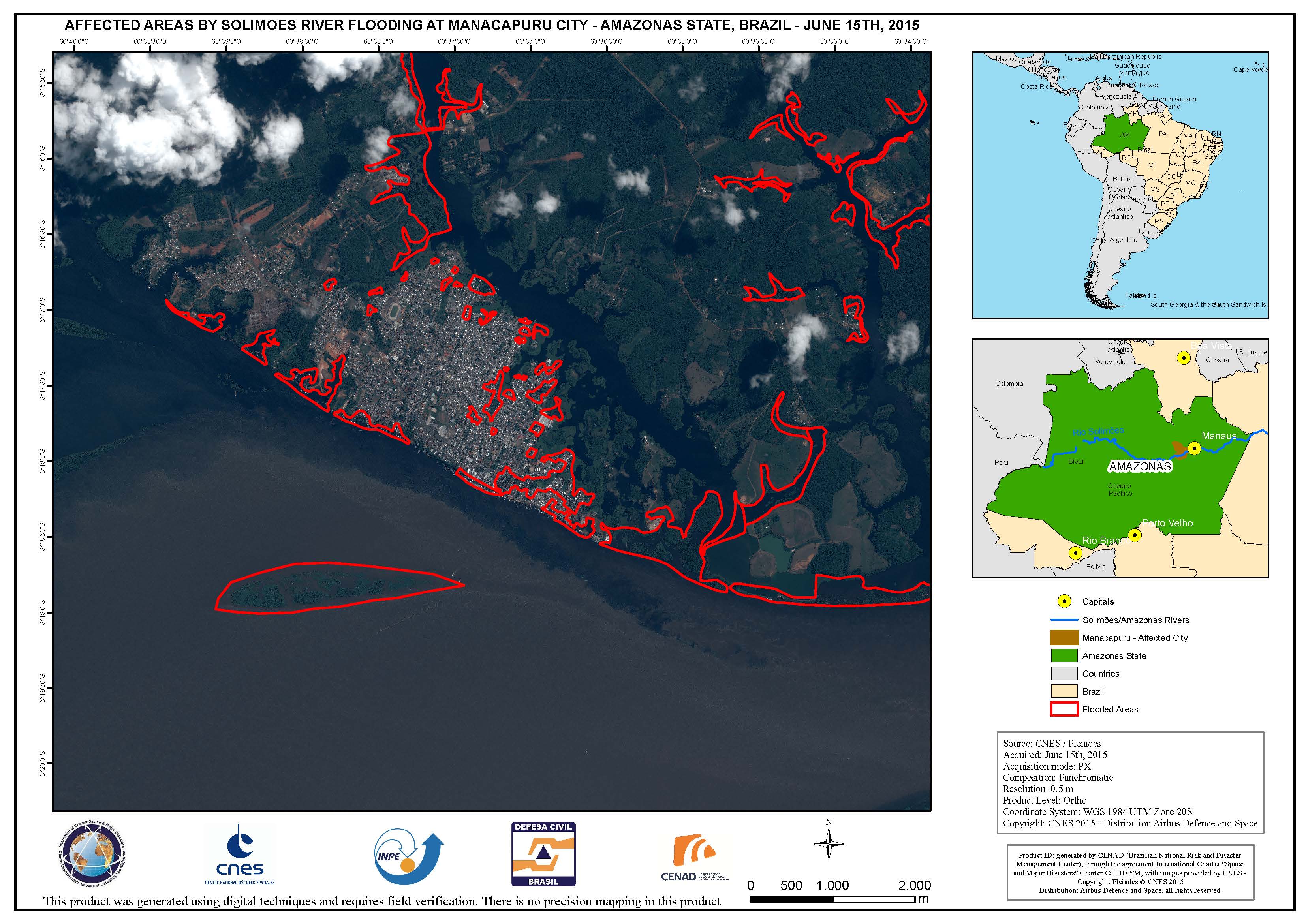
Areas affected by Solimoes River flooding at Manacapuru City, in Amazonas State
Авторские права: CNES 2015 - Distribution: Airbus Defence and Space, all rights reserved
Map produced by CENAD (Brazilian National Risk and Disaster Management Center)
Information about the Product
Получено: 15/06/2015
Источник: Pleiades
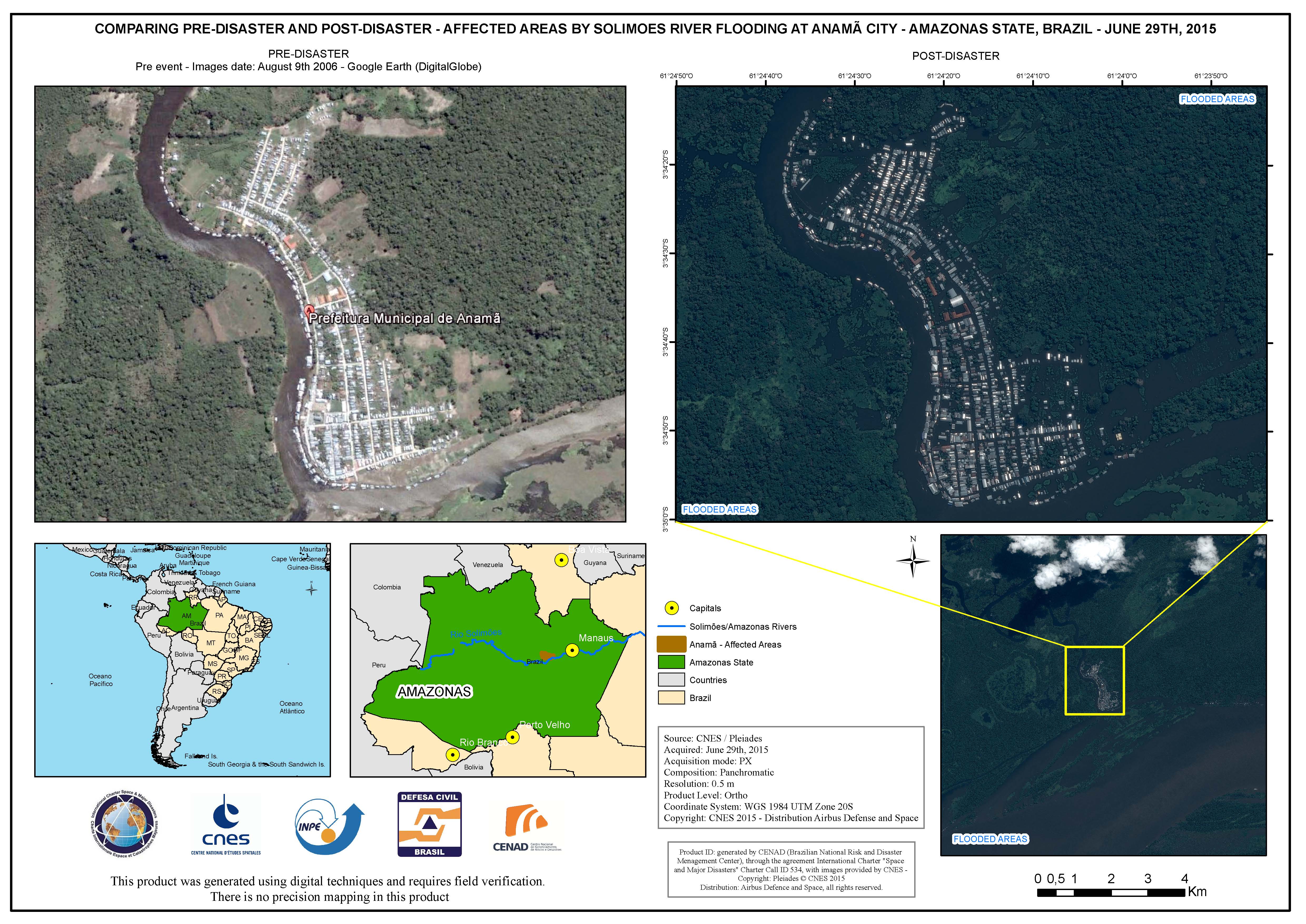
Comparison of areas affected by Solimoes River flooding at Anama City, in Amazonas State
Авторские права: CNES 2015 - Distribution: Airbus Defence and Space, all rights reserved
Map produced by CENAD (Brazilian National Risk and Disaster Management Center)
Information about the Product
Получено: Pre-disaster: 09/08/2006
Post-disaster: 29/06/2015
Источник: Pleiades
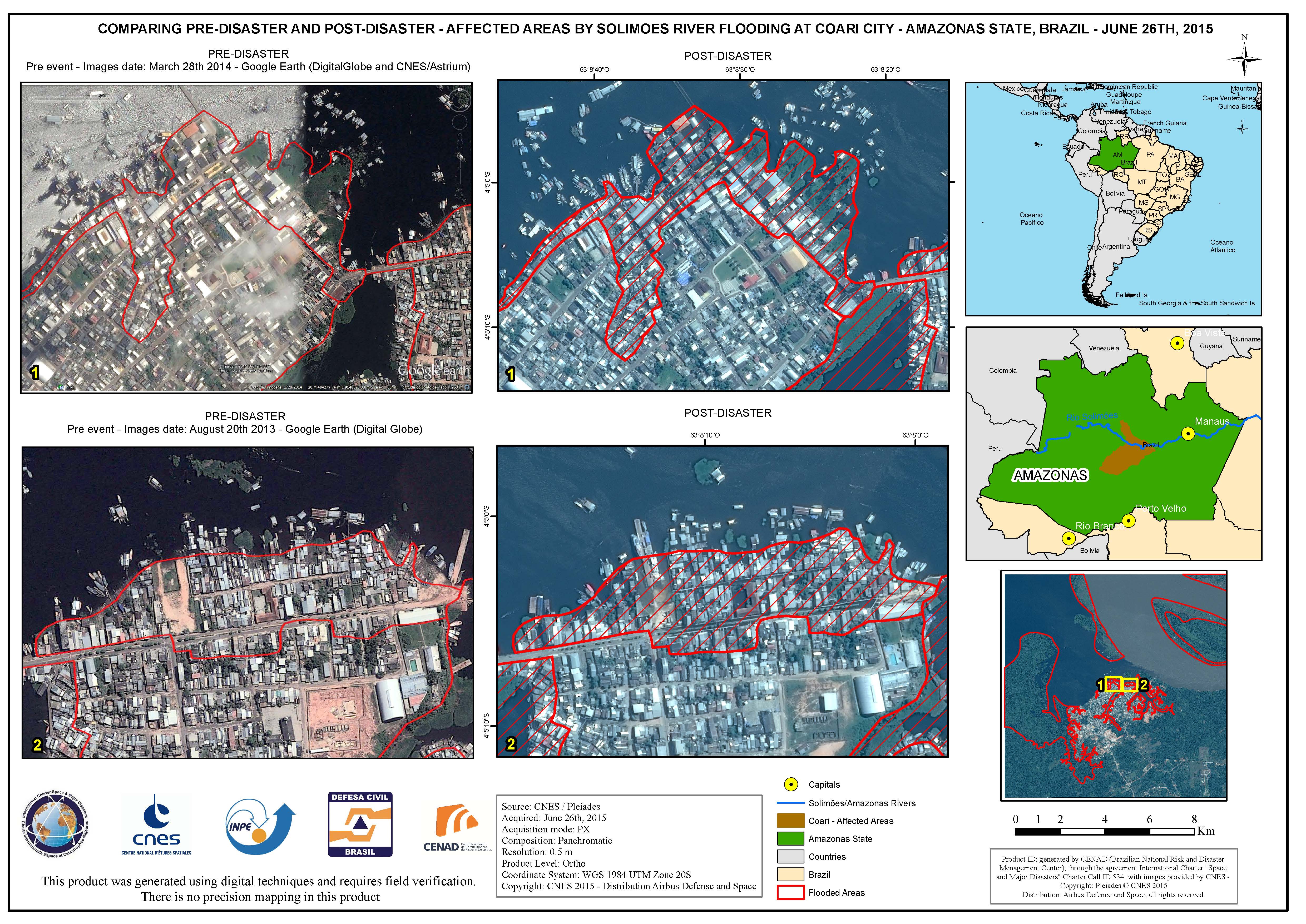
Comparison of areas affected by Solimoes River flooding at Coari City, in Amazonas State
Авторские права: CNES 2015 - Distribution: Airbus Defence and Space, all rights reserved
Map produced by CENAD (Brazilian National Risk and Disaster Management Center)
Information about the Product
Получено: Pre-disaster: 28/03/2014 and 20/08/2013
Post-disaster: 26/06/2015
Источник: Pleiades
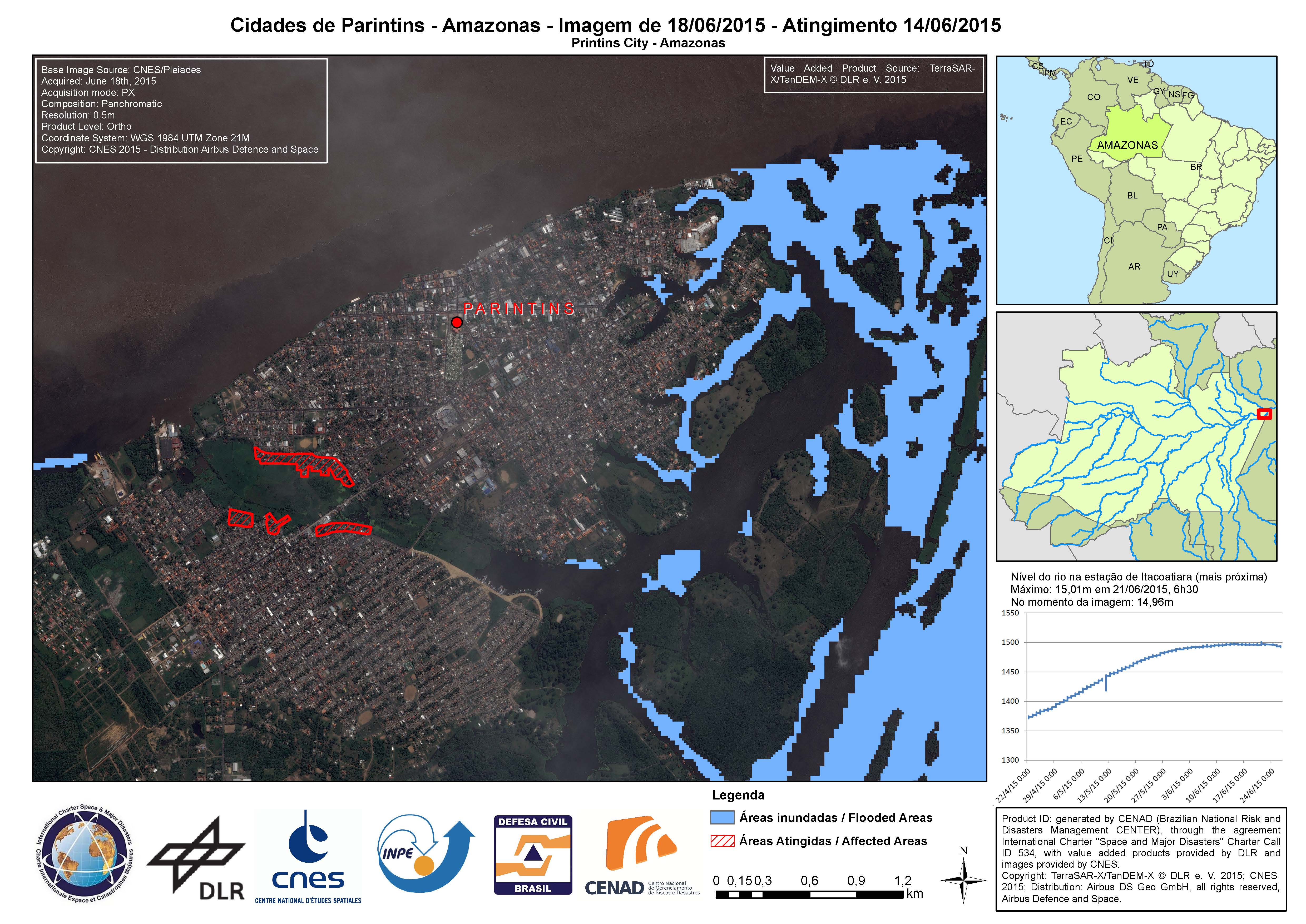
Parintins City in Amazonas State
Авторские права: German Aerospace Center (DLR), 2015 Airbus Defence and Space / Infoterra GmbH
Map produced by CENAD (Brazilian National Risk and Disaster Management Center)
Information about the Product
Получено: 14/06/2015 and 18/06/2015
Источник: TerraSAR-X / TanDEM-X
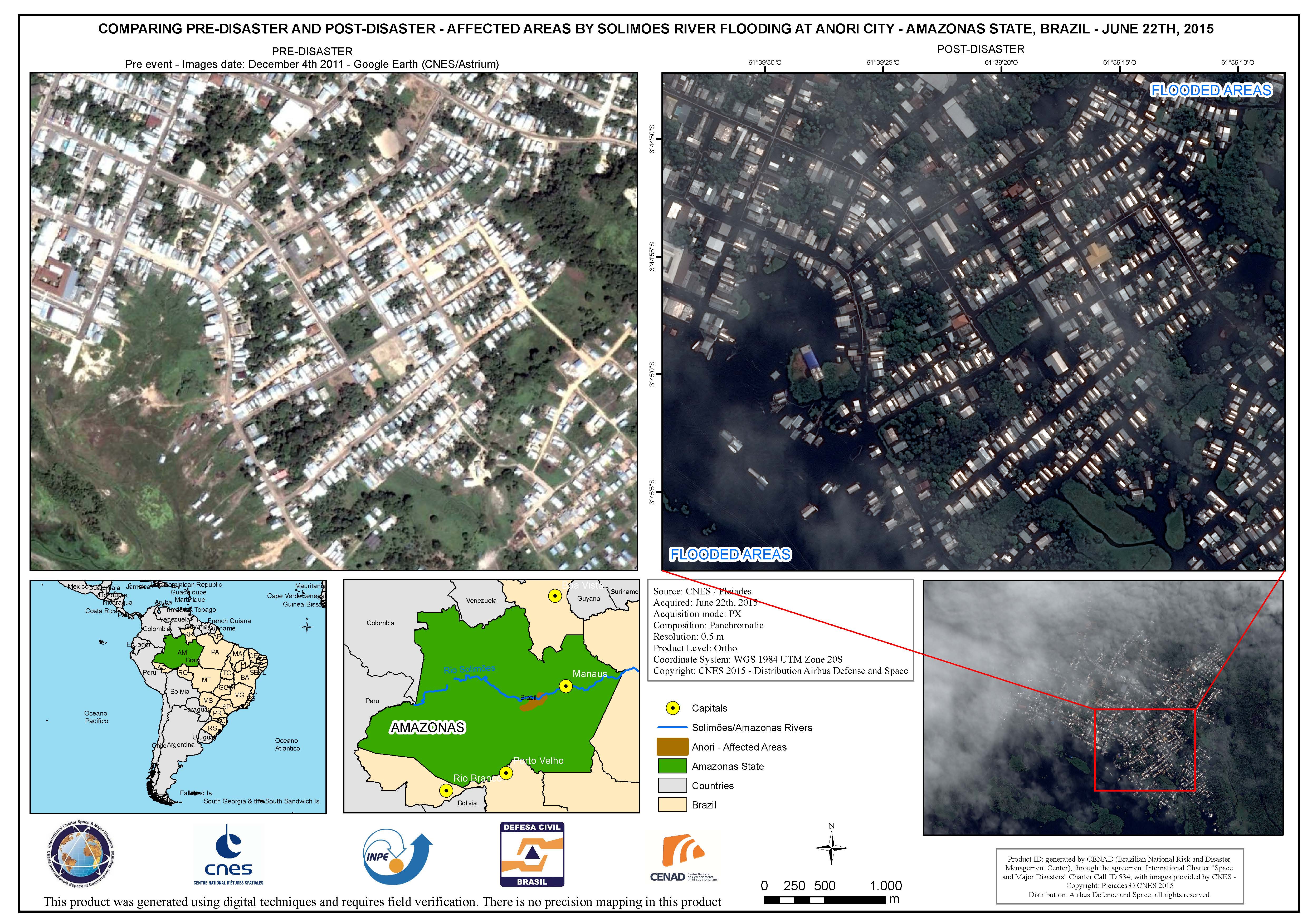
Comparison of areas affected by Solimoes River flooding at Anori City, in Amazonas State
Авторские права: CNES 2015 - Distribution: Airbus Defence and Space, all rights reserved
Map produced by CENAD (Brazilian National Risk and Disaster Management Center)
Information about the Product
Получено: Pre-disaster: 04/12/2011
Post-disaster: 22/06/2015
Источник: Pleiades
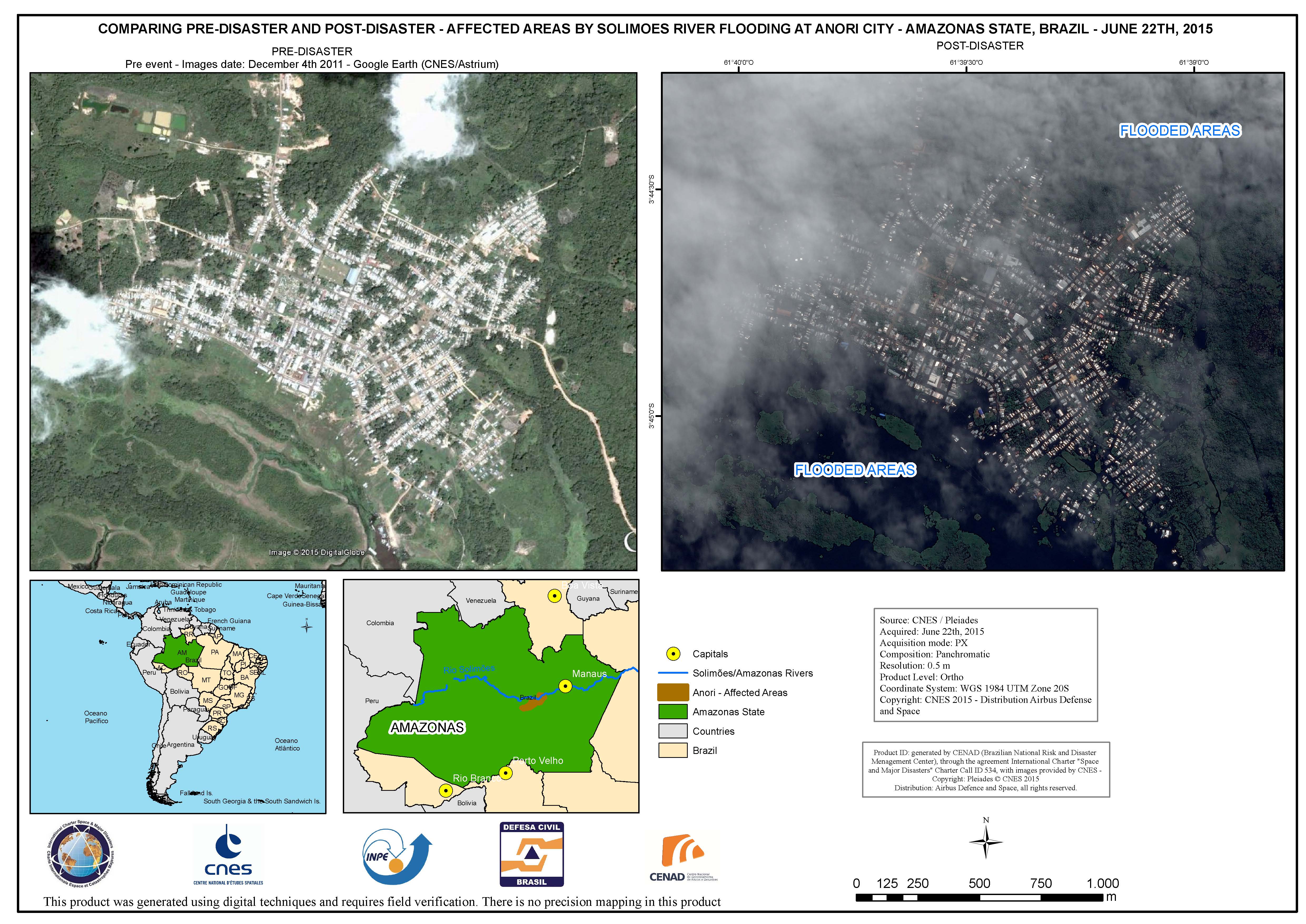
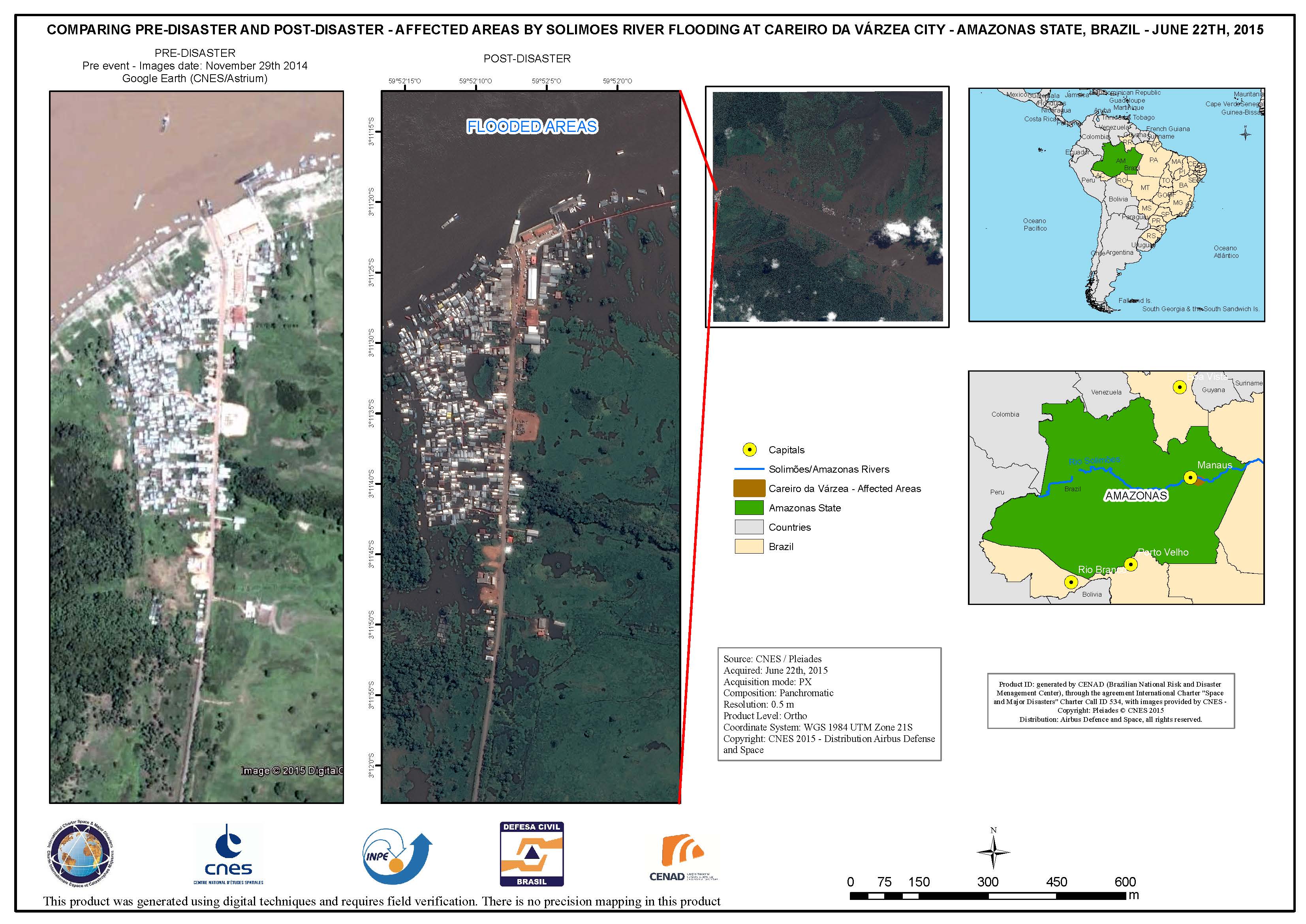
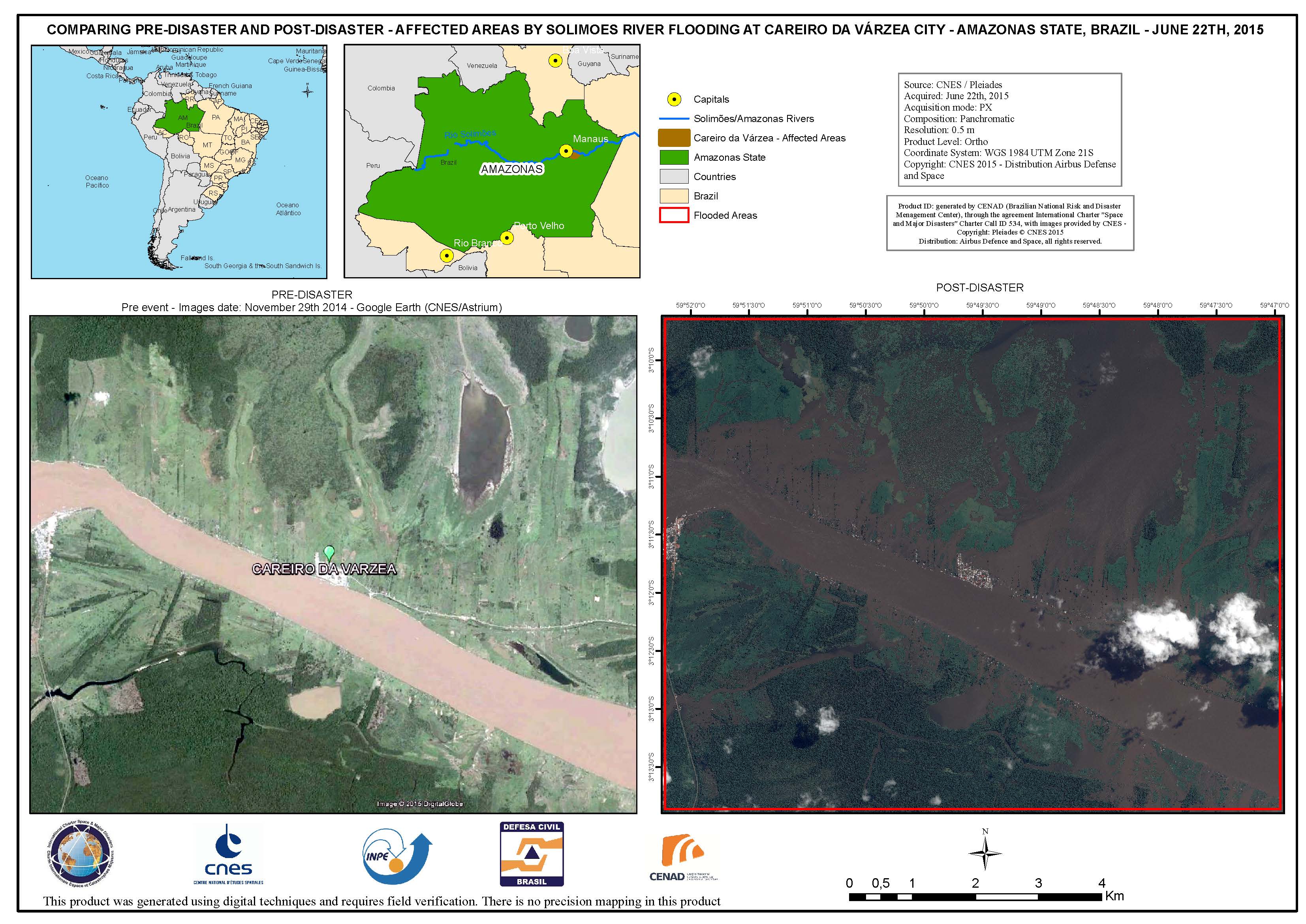
Comparison of areas affected by Solimoes River flooding at Careiro da Varzea City, in Amazonas State
Авторские права: CNES 2015 - Distribution: Airbus Defence and Space, all rights reserved
Map produced by CENAD (Brazilian National Risk and Disaster Management Center)
Information about the Product
Получено: Pre-disaster: 29/11/2014
Post-disaster: 22/06/2015
Источник: Pleiades
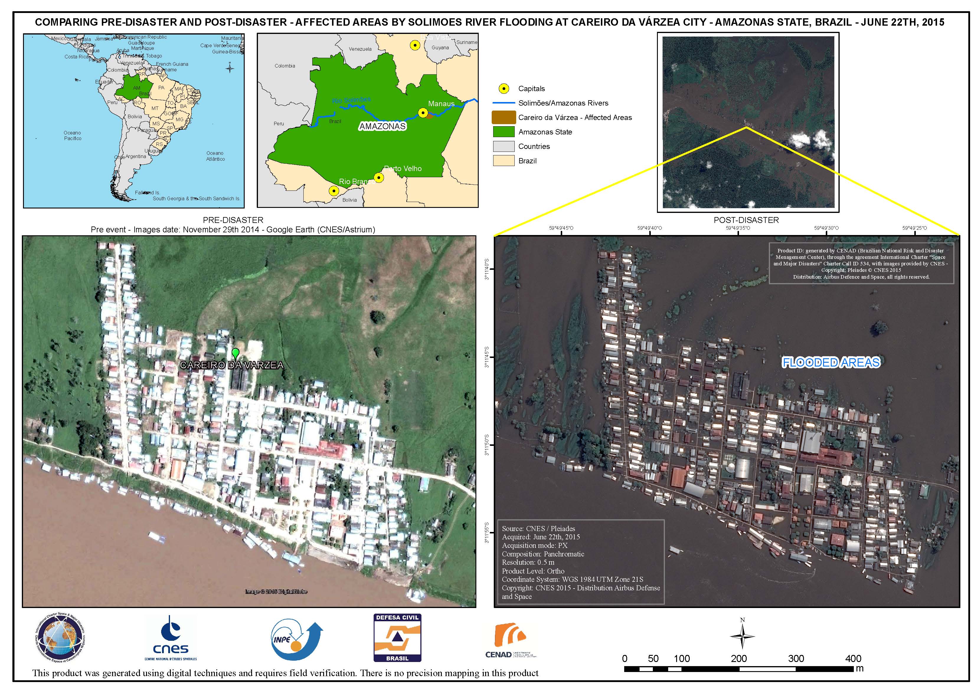
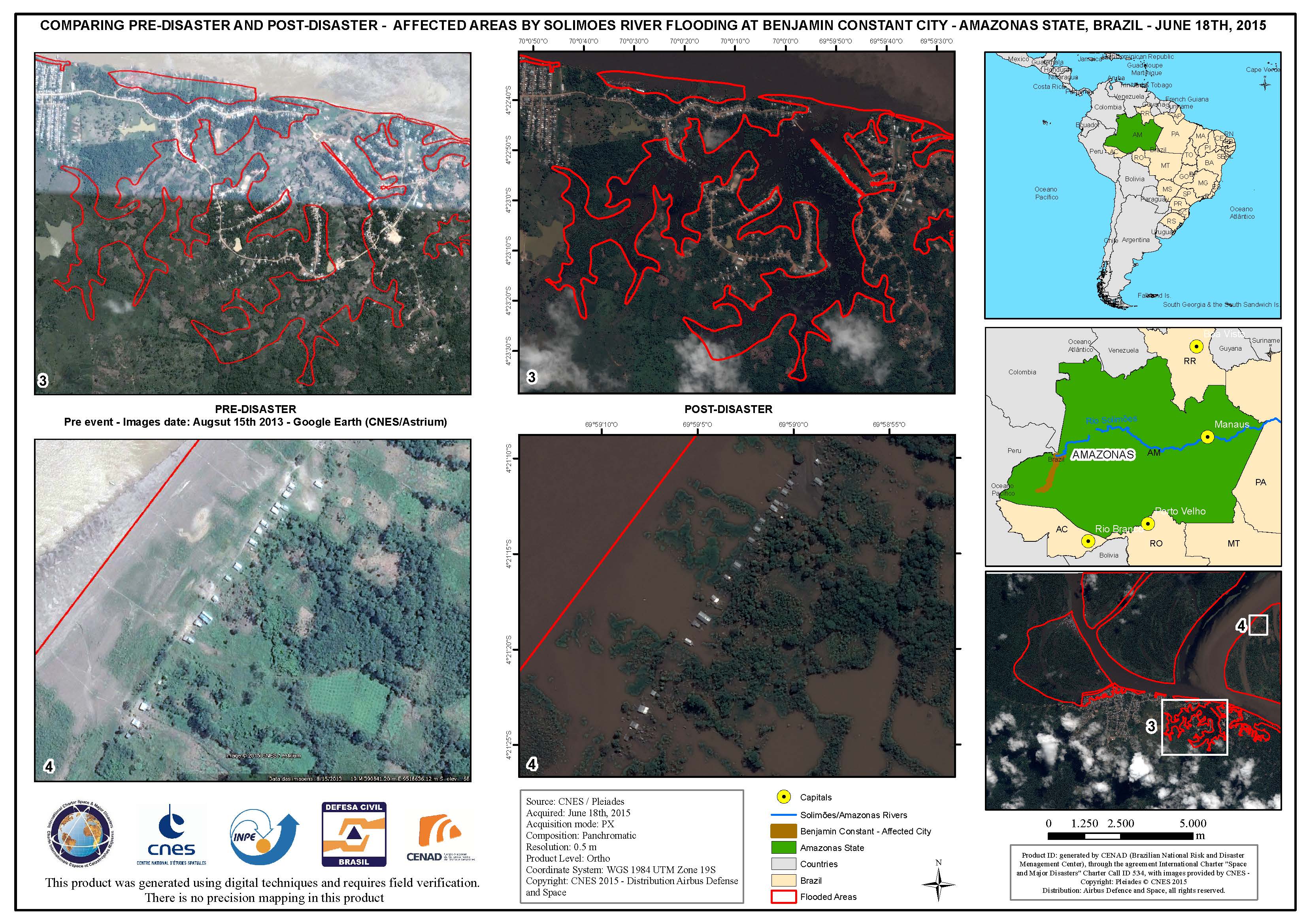
Comparison of areas affected by Solimoes River flooding at Benjamin Constant City, in Amazonas State
Авторские права: CNES 2015 - Distribution: Airbus Defence and Space, all rights reserved
Map produced by CENAD (Brazilian National Risk and Disaster Management Center)
Information about the Product
Получено: Pre-disaster: 15/08/2013
Post-disaster: 18/06/2015
Источник: Pleiades
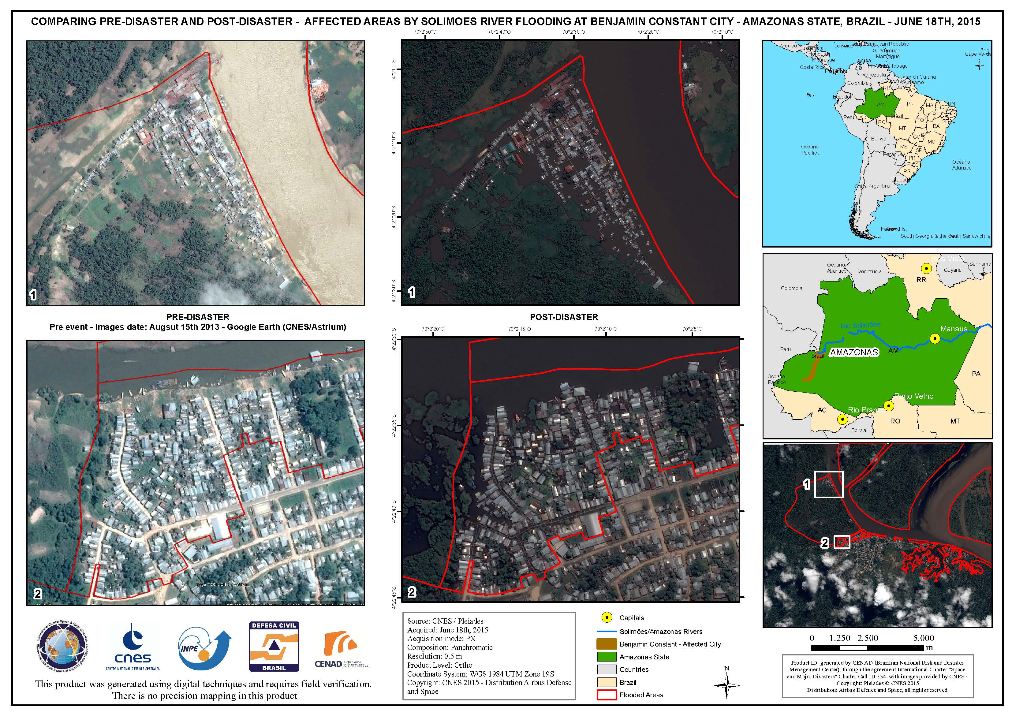
Comparison of areas affected by Solimoes River flooding at Benjamin Constant City, in Amazonas State
Авторские права: CNES 2015 - Distribution: Airbus Defence and Space, all rights reserved
Map produced by CENAD (Brazilian National Risk and Disaster Management Center)
Information about the Product
Получено: Pre-disaster: 15/08/2013
Post-disaster: 18/06/2015
Источник: Pleiades

Areas affected by Solimoes River flooding at Benjamin Constant City, in Amazonas State
Авторские права: CNES 2015 - Distribution: Airbus Defence and Space, all rights reserved
Map produced by CENAD (Brazilian National Risk and Disaster Management Center)
Information about the Product
Получено: 18/06/2015
Источник: Pleiades
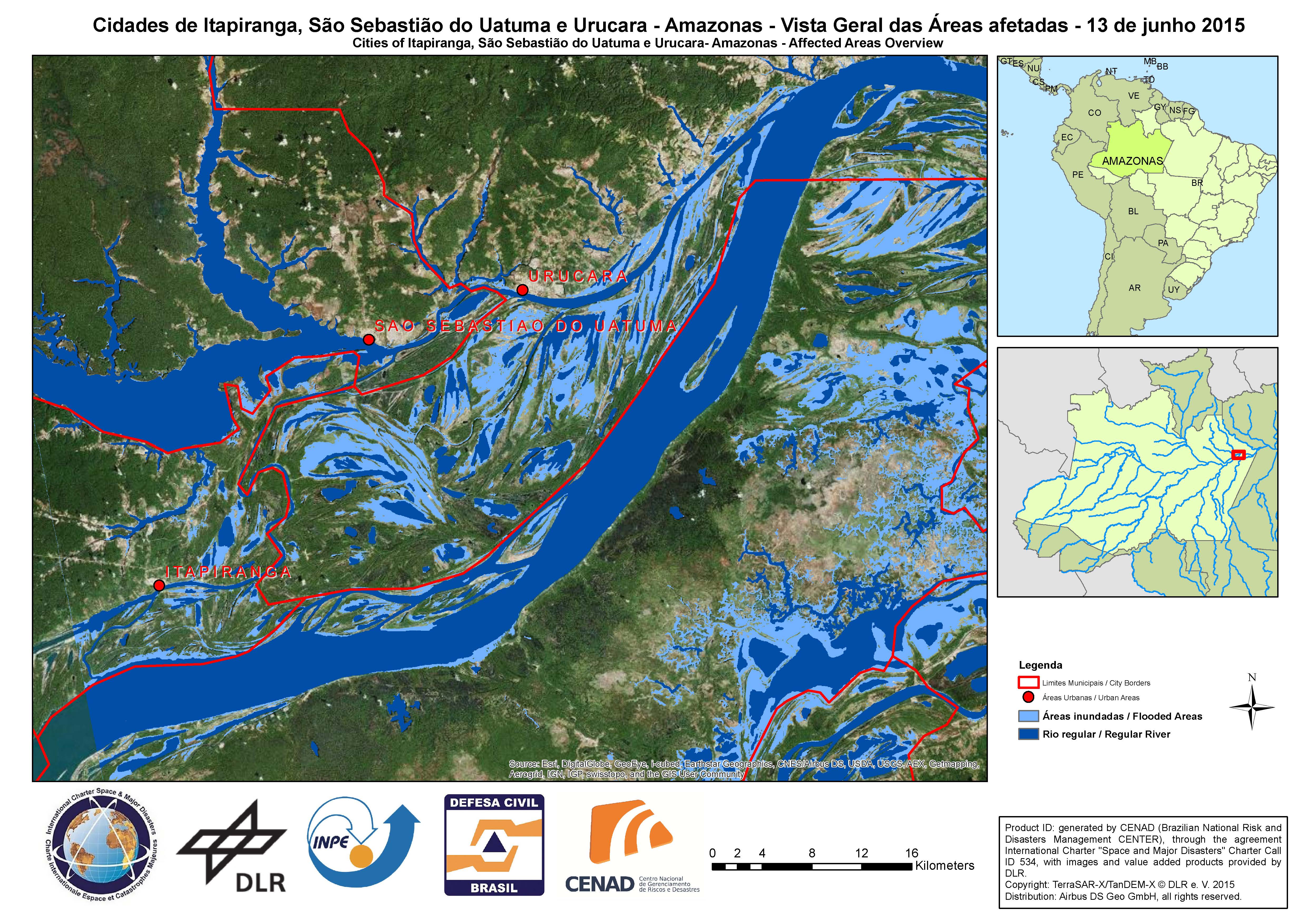
Affected areas overview - Cities of Itapiranga, Sao Sebastiao do Uatuma e Urucara, in Amazonas State
Авторские права: German Aerospace Center (DLR), 2015 Airbus Defence and Space / Infoterra GmbH
Map produced by CENAD (Brazilian National Risk and Disaster Management Center)
Information about the Product
Получено: 13/06/2015
Источник: TerraSAR-X / TanDEM-X
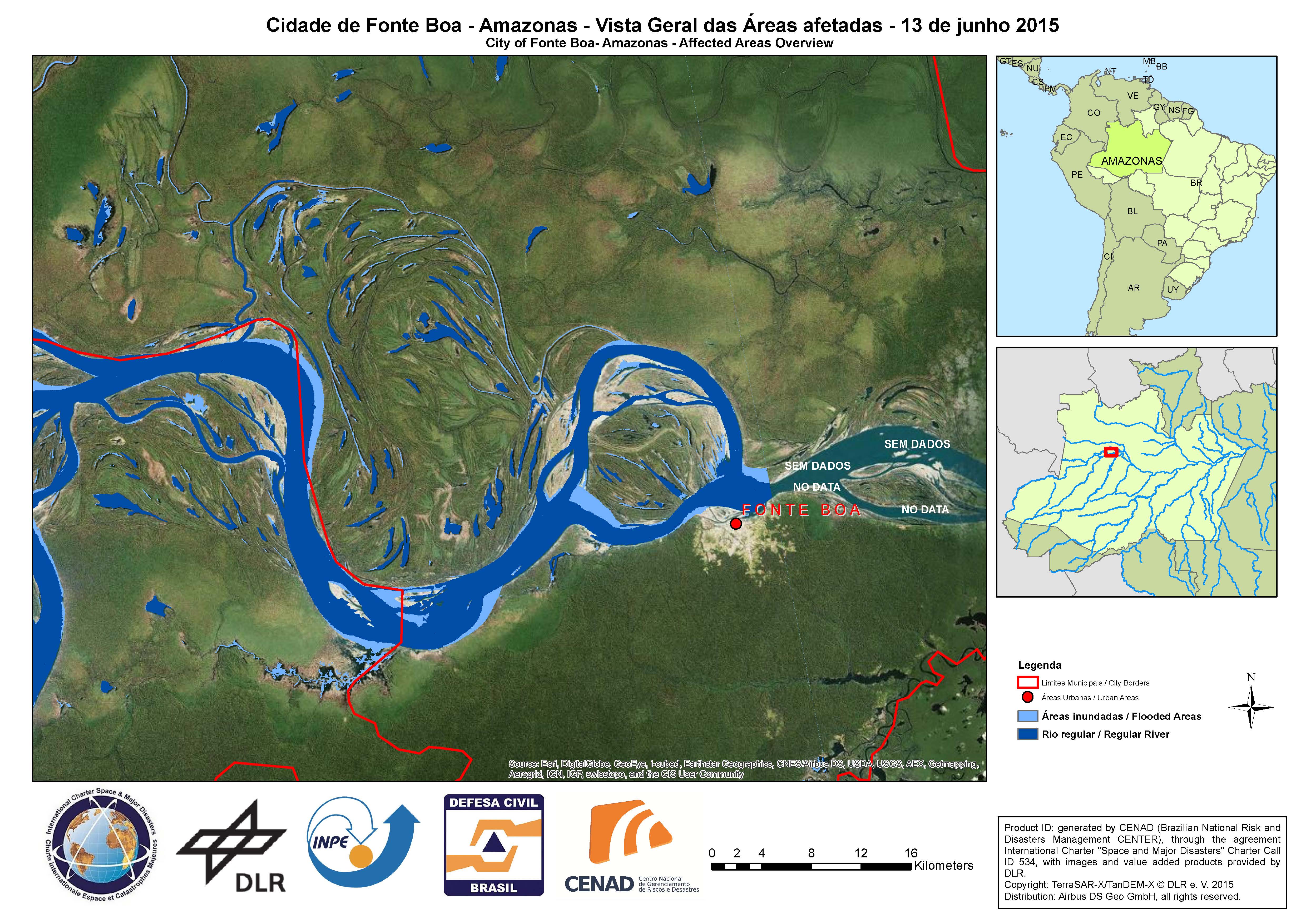
Affected areas overview - City of Fonte Boa in Amazonas State
Авторские права: German Aerospace Center (DLR), 2015 Airbus Defence and Space / Infoterra GmbH
Map produced by CENAD (Brazilian National Risk and Disaster Management Center)
Information about the Product
Получено: 13/06/2015
Источник: TerraSAR-X / TanDEM-X
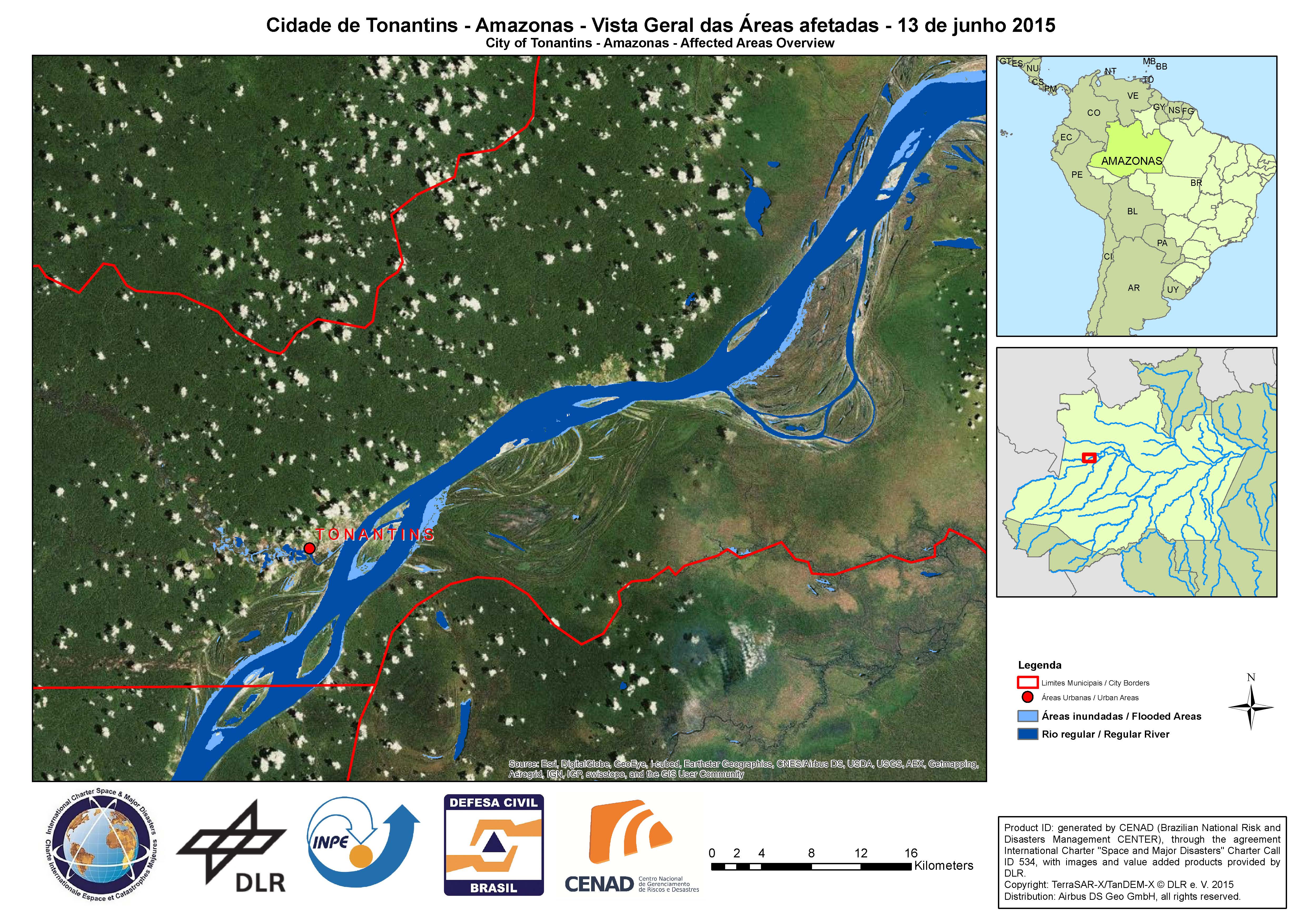
Affected areas overview - City of Tonantins in Amazonas State
Авторские права: German Aerospace Center (DLR), 2015 Airbus Defence and Space / Infoterra GmbH
Map produced by CENAD (Brazilian National Risk and Disaster Management Center)
Information about the Product
Получено: 13/06/2015
Источник: TerraSAR-X / TanDEM-X
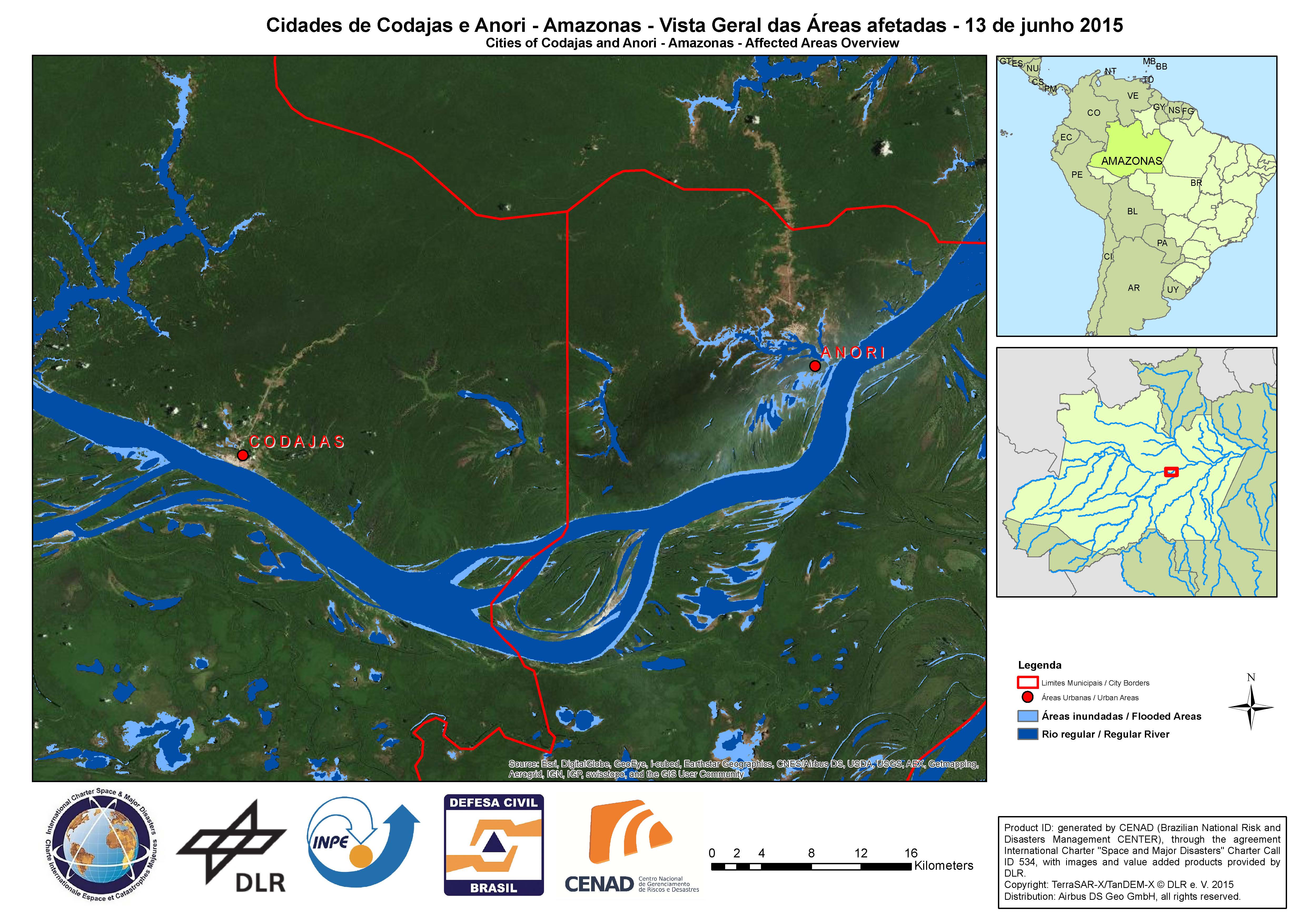
Affected areas overview - Cities of Codajas and Anori, in Amazonas State
Авторские права: German Aerospace Center (DLR), 2015 Airbus Defence and Space / Infoterra GmbH
Map produced by CENAD (Brazilian National Risk and Disaster Management Center)
Information about the Product
Получено: 13/06/2015
Источник: TerraSAR-X / TanDEM-X
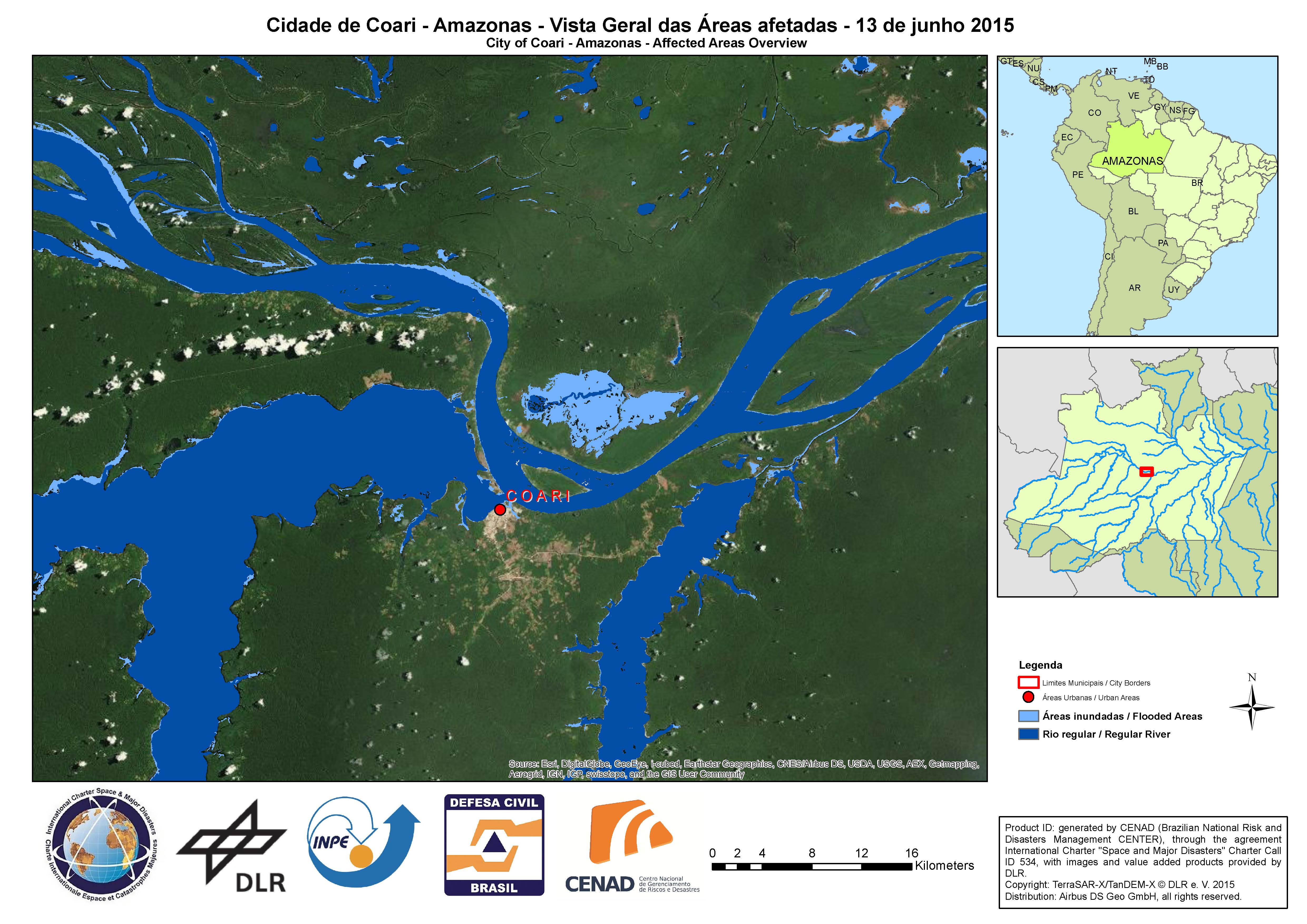
Affected areas overview - City of Coari in Amazonas State
Авторские права: German Aerospace Center (DLR), 2015 Airbus Defence and Space / Infoterra GmbH
Map produced by CENAD (Brazilian National Risk and Disaster Management Center)
Information about the Product
Получено: 13/06/2015
Источник: TerraSAR-X / TanDEM-X
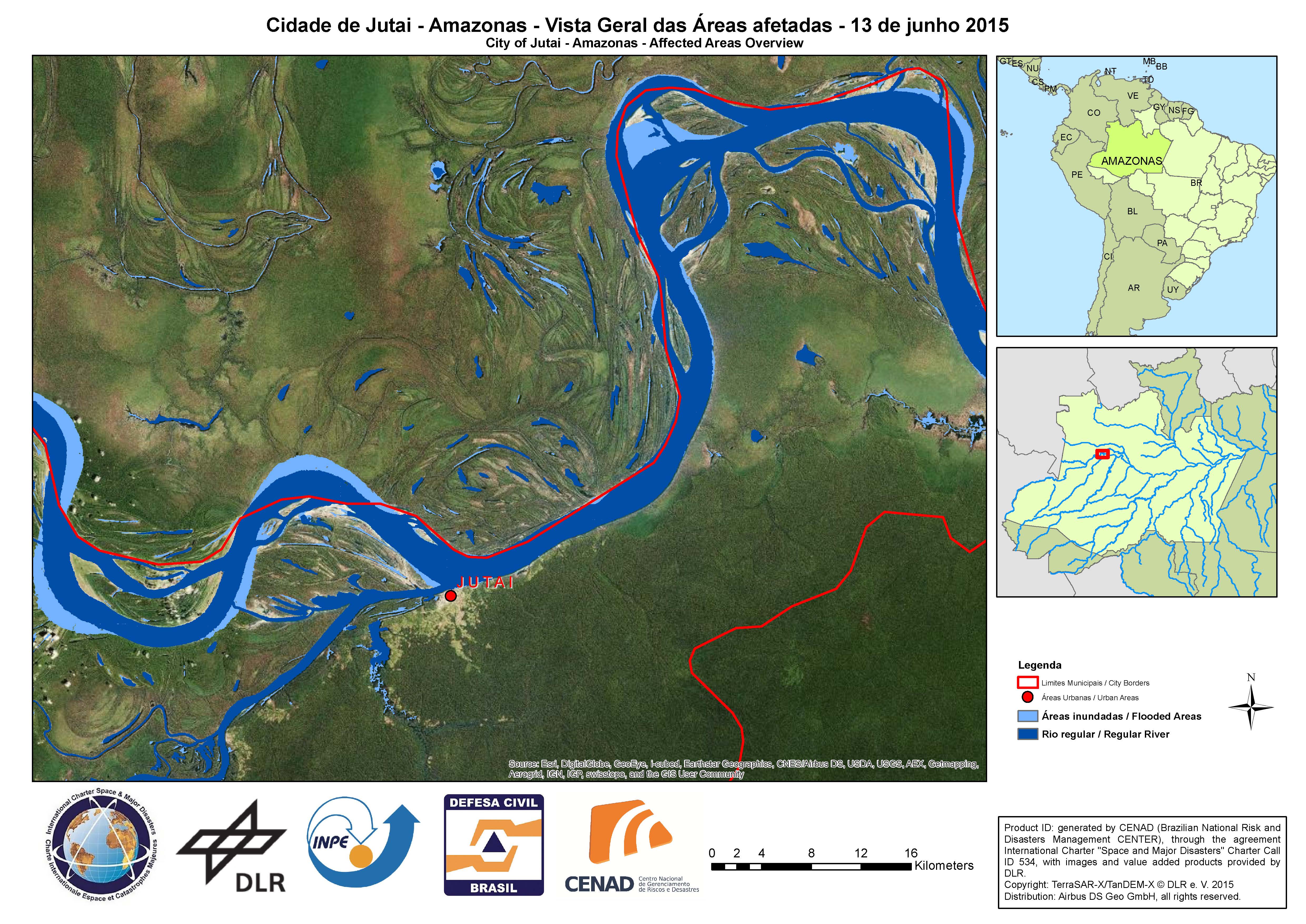
Affected areas overview - City of Jutai in Amazonas State
Авторские права: German Aerospace Center (DLR), 2015 Airbus Defence and Space / Infoterra GmbH
Map produced by CENAD (Brazilian National Risk and Disaster Management Center)
Information about the Product
Получено: 13/06/2015
Источник: TerraSAR-X / TanDEM-X
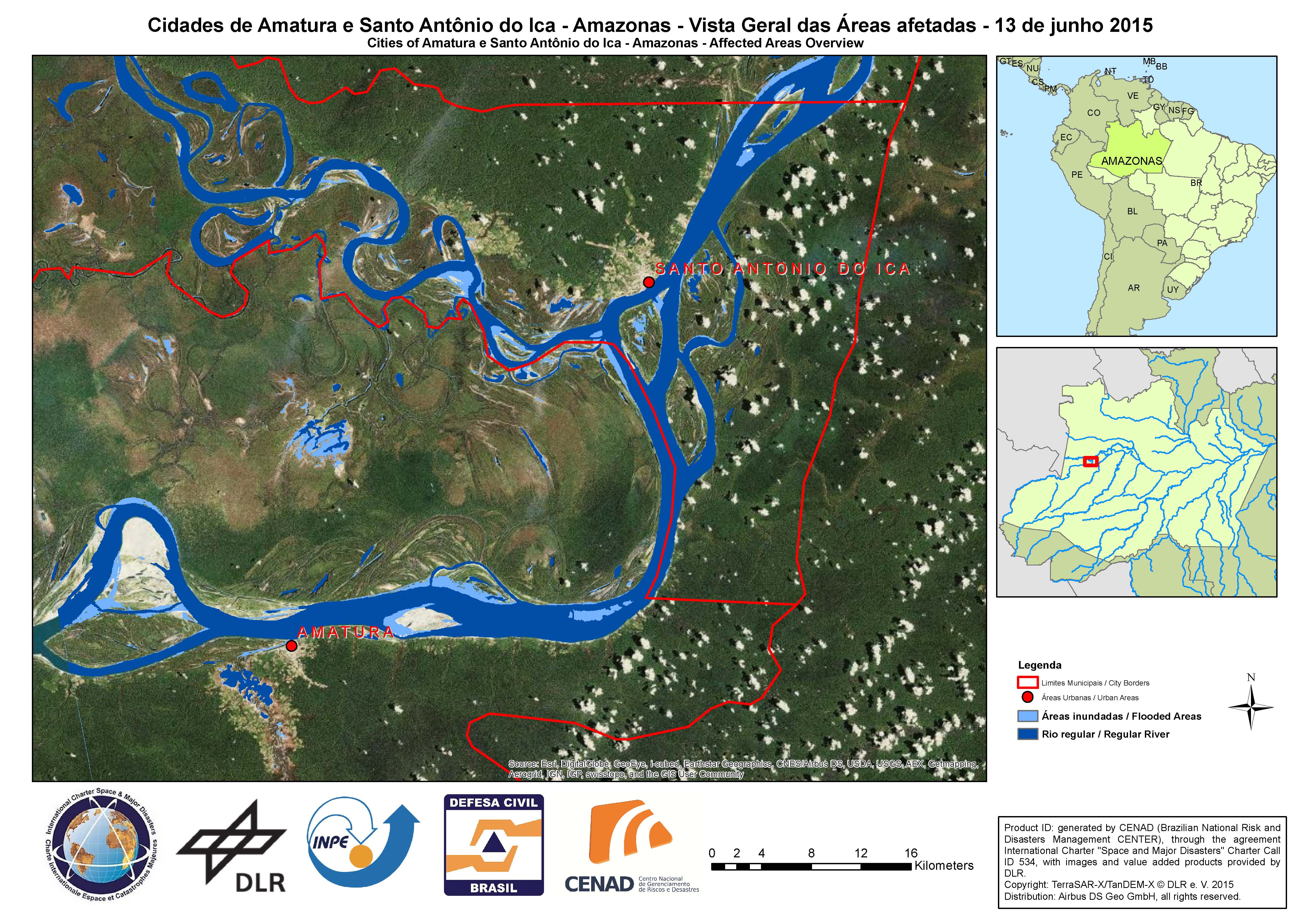
Affected areas overview - Cities of Amatura and Santo Antonio do Ica in Amazonas State
Авторские права: German Aerospace Center (DLR), 2015 Airbus Defence and Space / Infoterra GmbH
Map produced by CENAD (Brazilian National Risk and Disaster Management Center)
Information about the Product
Получено: 13/06/2015
Источник: TerraSAR-X / TanDEM-X
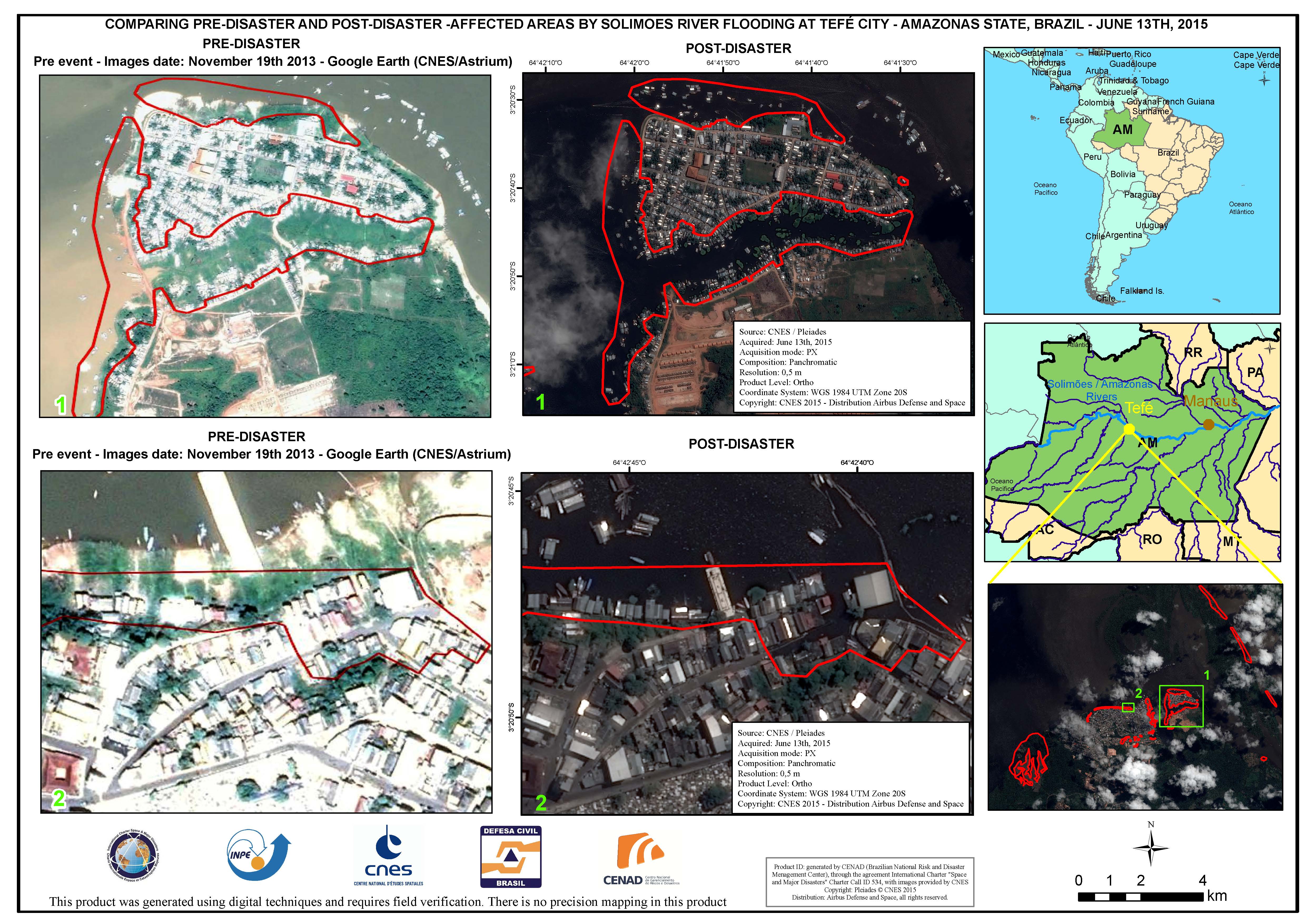
Comparison of areas affected by Solimoes River flooding at Tefe City, in Amazonas State, Brazil
Авторские права: CNES 2015 - Distribution: Airbus Defence and Space, all rights reserved
Map produced by CENAD (Brazilian National Risk and Disaster Management Center)
Information about the Product
Получено: Pre-disaster: 19/11/2013
Post-disaster: 13/06/2015
Источник: Pleiades
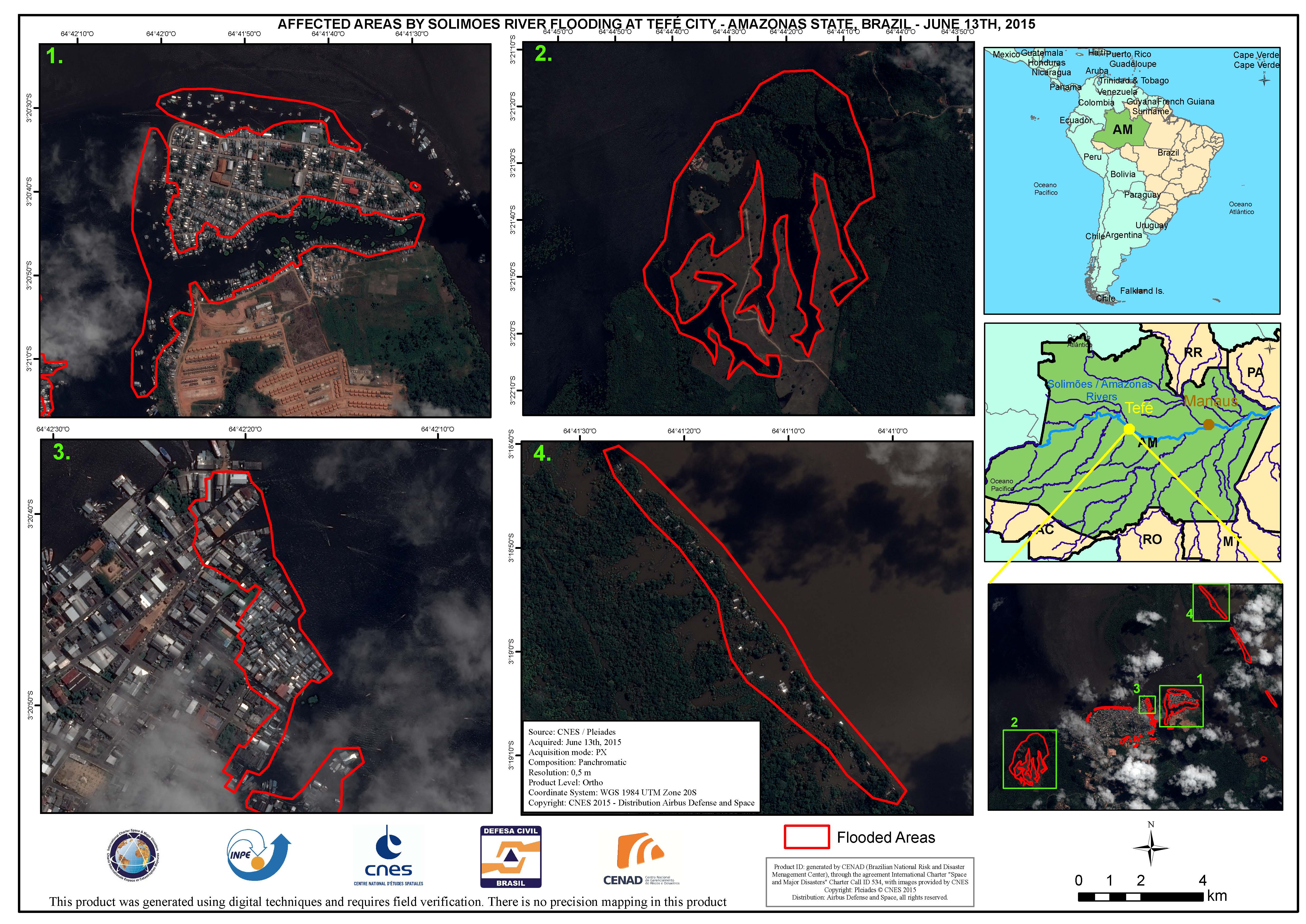
Areas affected by Solimoes River flooding at Tefe City, in Amazonas State, Brazil
Авторские права: CNES 2015 - Distribution: Airbus Defence and Space, all rights reserved
Map produced by CENAD (Brazilian National Risk and Disaster Management Center)
Information about the Product
Получено: 13/06/2015
Источник: Pleiades
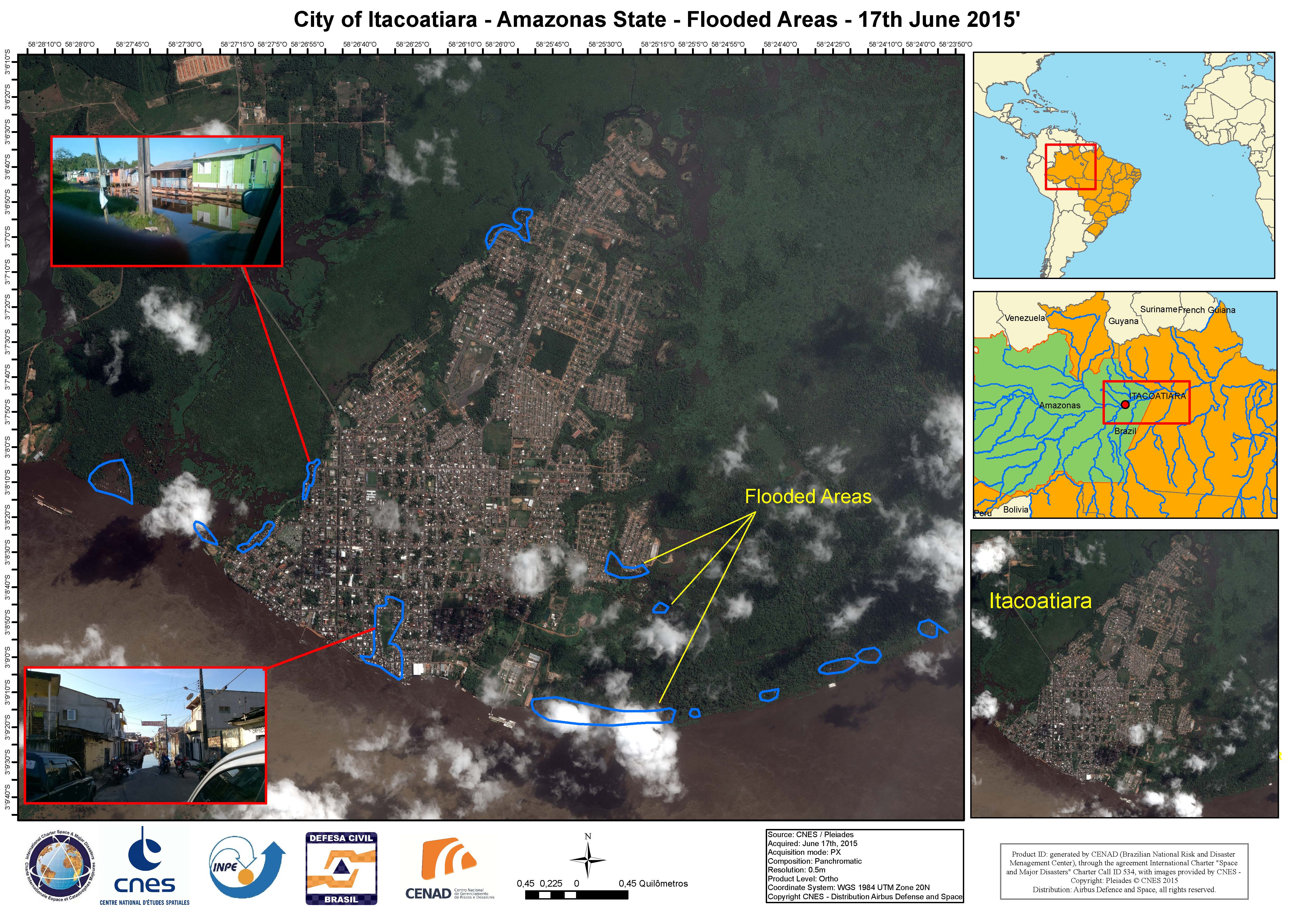
Flooded areas in the city of Itacoatiara, Amazonas State, Brazil
Авторские права: CNES 2015 - Distribution: Airbus Defence and Space, all rights reserved
Map produced by CENAD (Brazilian National Risk and Disaster Management Center)
Information about the Product
Получено: 17/06/2015
Источник: Pleiades
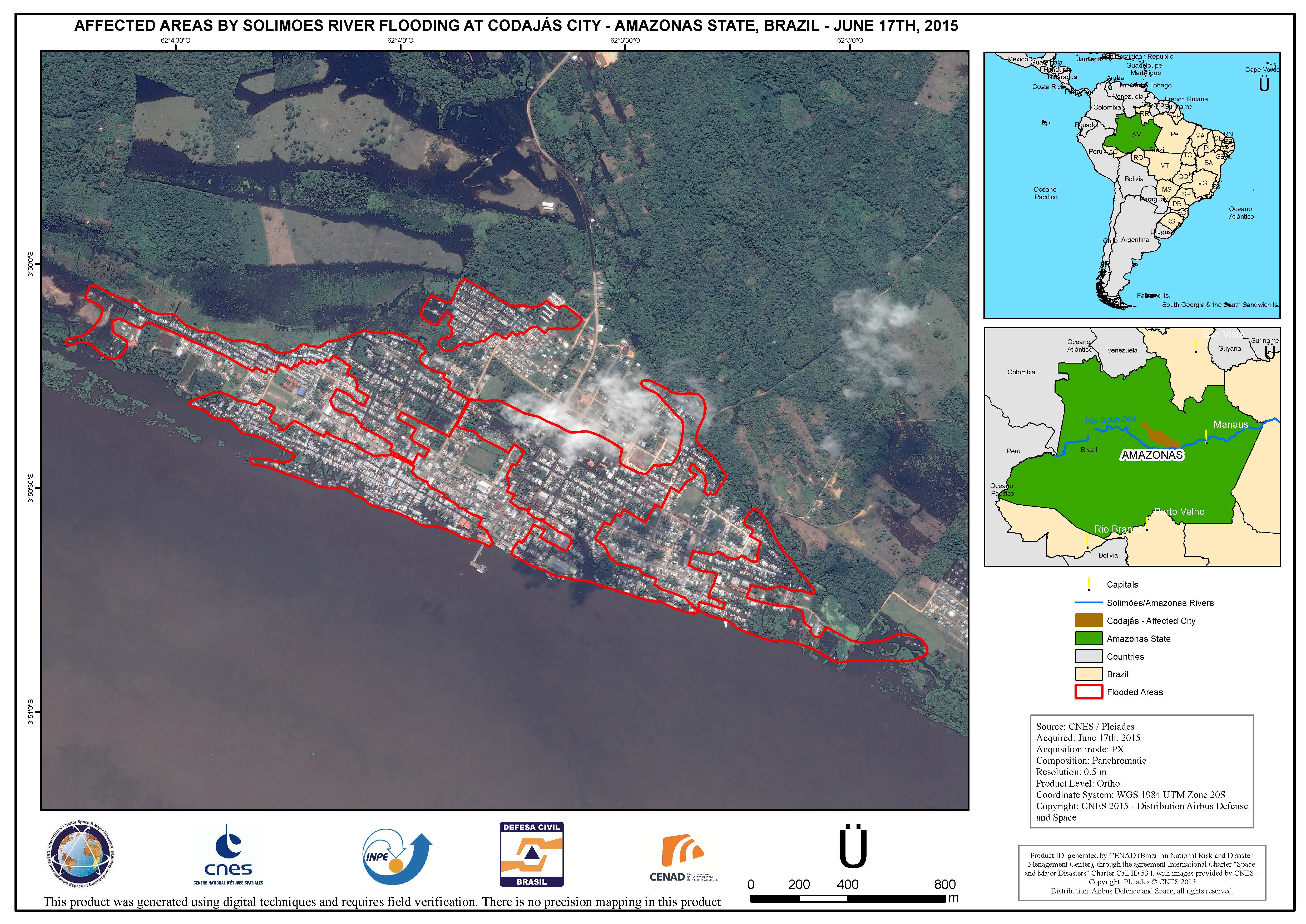
Areas affected by Solimoes River flooding at Codajas City, in Amazonas State, Brazil
Авторские права: CNES 2015 - Distribution: Airbus Defence and Space, all rights reserved
Map produced by CENAD (Brazilian National Risk and Disaster Management Center)
Information about the Product
Получено: 17/06/2015
Источник: Pleiades
 Вернуться к полному архиву активаций

