 English
 Spanish
 French
 Chinese
 Russian
 Portuguese
 Latest Activation
Charter activations
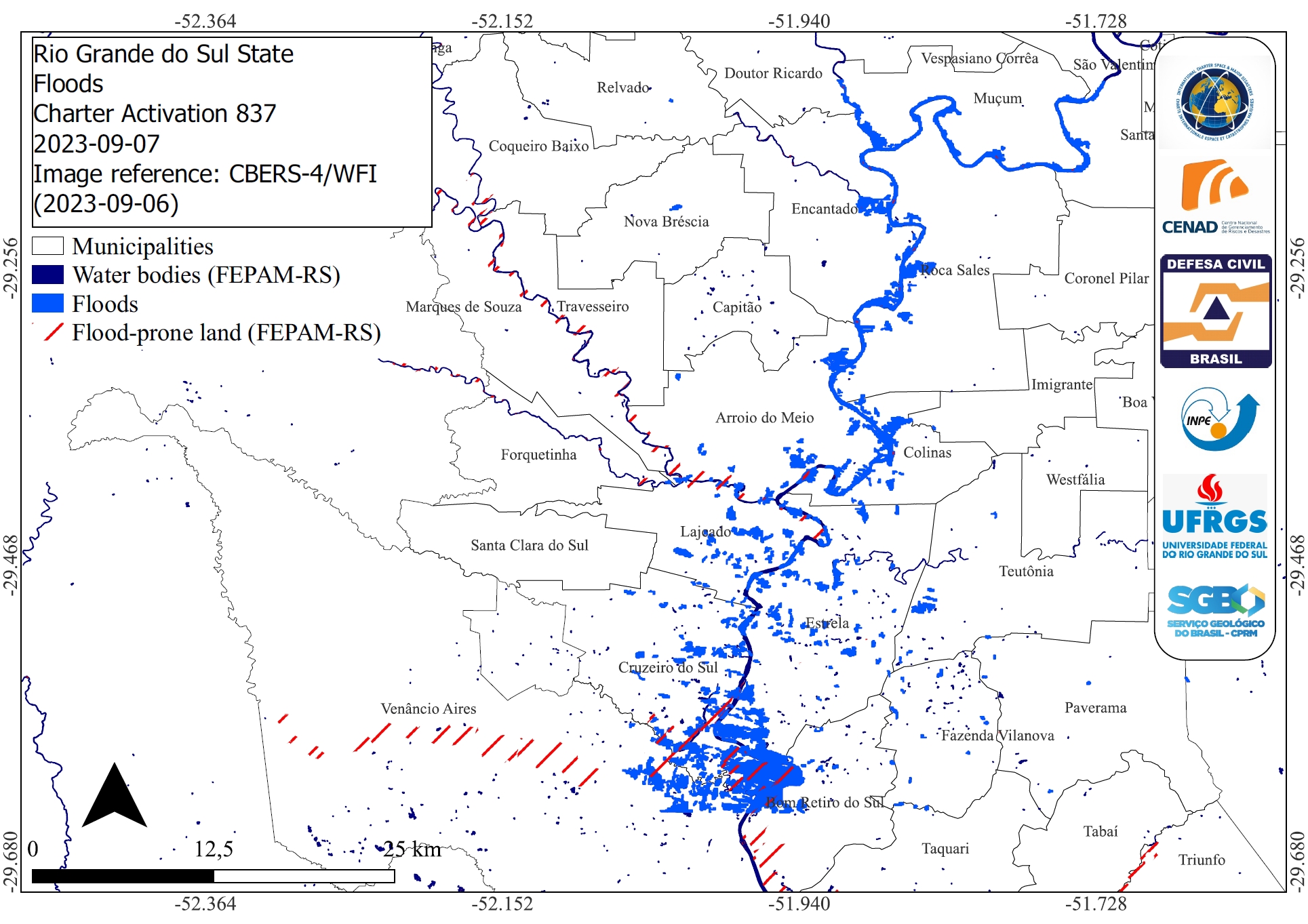
Extratropical Cyclone in southern Brazil
Torrential rain and winds caused by an extratropical cyclone left 27 people dead in southern Brazil at the start of September. The death toll is the highest recorded in the state for a climate event.
Several municipalities in Rio Grande do Sul were affected after more than 300mm (11 inches) of rain hit the state in less than 24 hours, triggering floods as rivers overflowed their banks and landslides. A total of 60 cities were battered by the storm and at least 1,650 people made homeless.
In the days following the disaster, rescuers searched for people stranded in flooded areas and the police and military deployed aircraft, helicopters and boats to help with the search and rescue operation.
This extreme flood event comes after Rio Grande do Sul was slammed by another cyclone in June that claimed the lives of at least 11 people. One of the many weather-related disasters to have recently struck Brazil.
| Type of Event: | Floods |
| Location of Event: | Brazil |
| Date of Charter Activation: | 2023-09-06 |
| Time of Charter Activation: | 19:54 |
| Time zone of Charter Activation: | UTC-03:00 |
| Charter Requestor: | CENAD |
| Activation ID: | 837 |
| Project Management: | Pedro Youssef (CENAD) |
| Value Adding: | Laercio Massaru Namikawa (INPE) UFRGS Alisson Oliveira (INPE) Luiza Rosa (UFRGS) SGB Artur Jose Soares Matos (SGB) Denilson Jesus (CPRM) NOAA VA (NOAA) Sergio Molano (UFRGS) INPE Rodrigo Augusto Stabile (CEMADEN) Thales Korting (INPE) |
Products
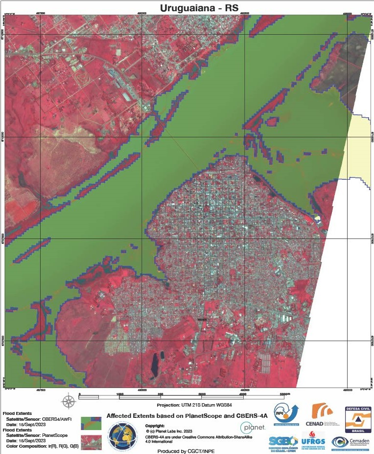
Areas affected by flooding in Uruguaiana, Rio Grande do Sul, Brazil
Copyright: CBERS-4 © (2023) INPE, © Planet Labs Inc. (2023)
Map produced by INPE (Instituto Nacional de Pesquisas Espaciais).
Information about the Product
Acquired: CBERS: 15/09/2023
PlanetScope: 15/09/2023
Source: CBERS-4 and PlanetScope
Category: Delineation Map
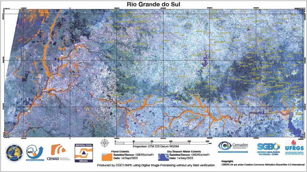
Extent of Flooding compared to Dry Season Water Extents in the Rio Grande do Sul state, Brazil
Copyright: CBERS-4 (2023) © INPE
Map produced by INPE (Instituto Nacional de Pesquisas Espaciais).
Information about the Product
Acquired: 14/05/2023 and 15/09/2023
Source: CBERS-4
Category: Delineation Map
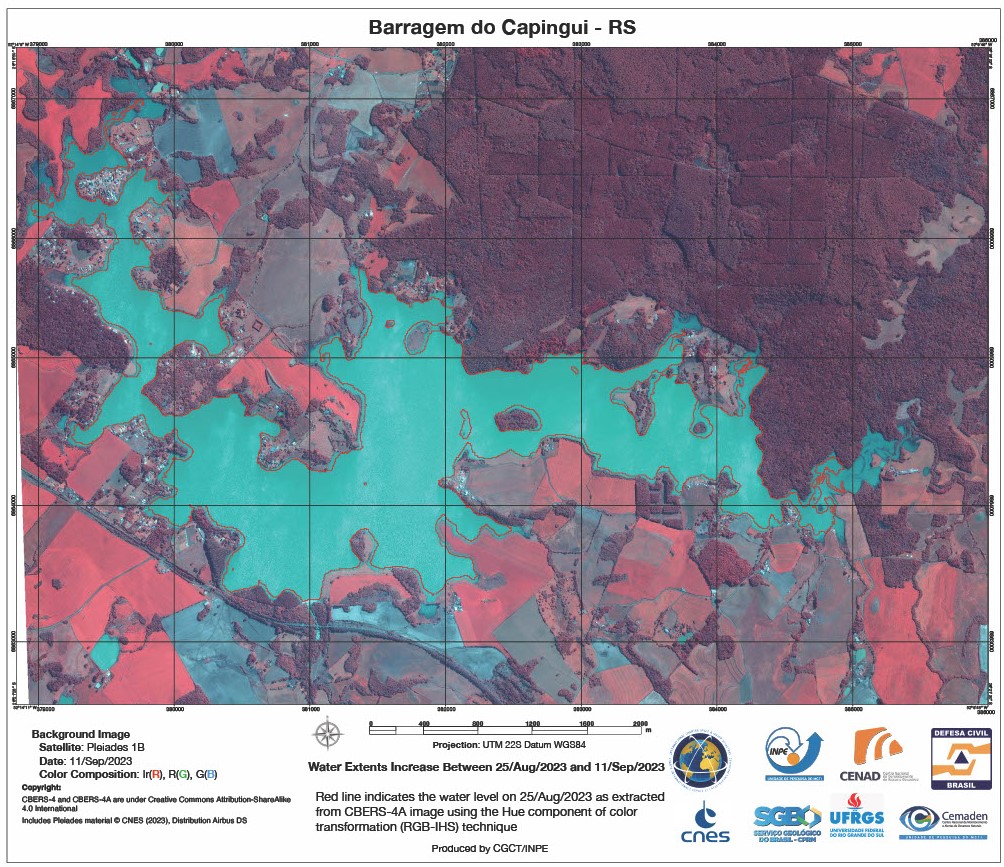
Increased water extents of the Capingui Dam, Brazil
Copyright: CBERS-4 (2023) © INPE
Includes Pleiades material © CNES (2023), Distribution Airbus DS.
Map produced by INPE (Instituto Nacional de Pesquisas Espaciais).
Information about the Product
Acquired: CBERS-4: 25/08/2023
Pleiades: 11/09/2023
Source: CBERS-4 and Pleiades
Category: Delineation Map
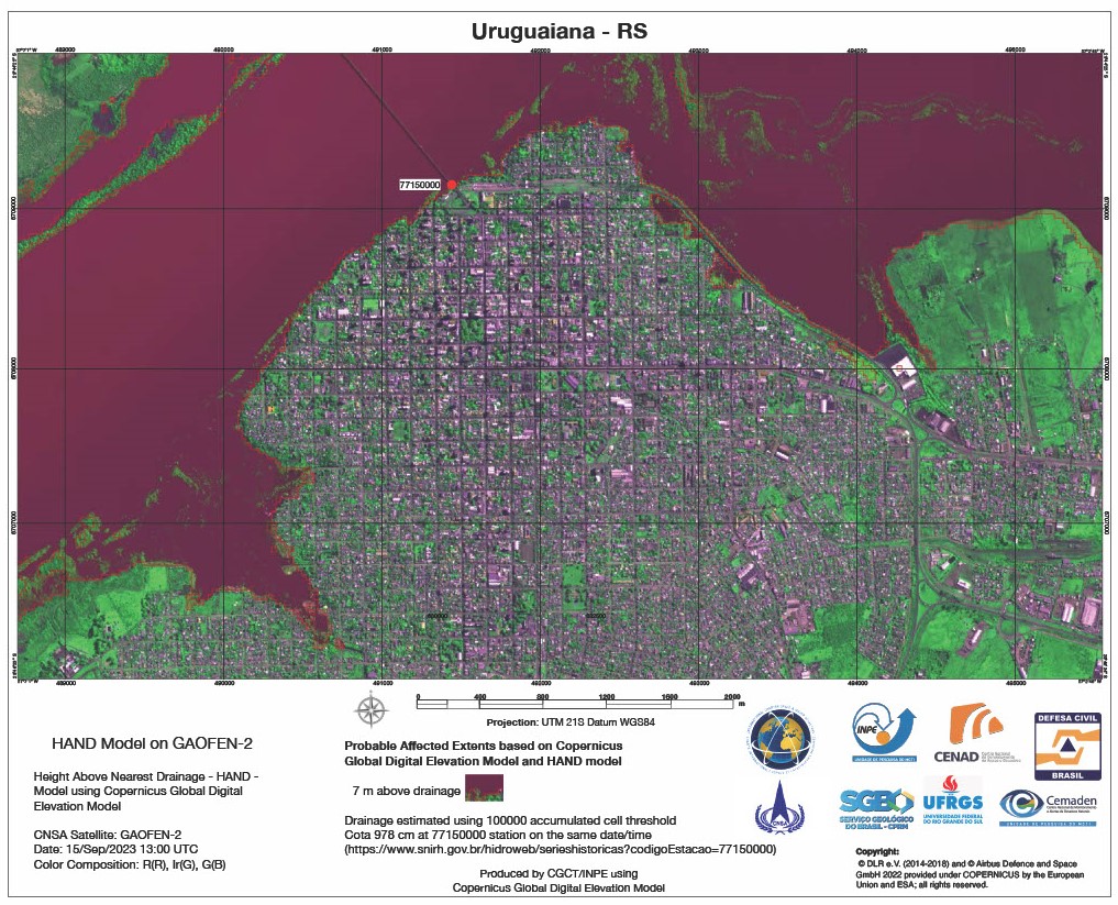
Probable Affected Extents based on Copernicus Global Digital Elevation Model and HAND model in the municipality of Uruguaiana, Brazil
Copyright: © CNSA/CRESDA (2023)
Map produced by INPE (Instituto Nacional de Pesquisas Espaciais).
Information about the Product
Acquired: 15/09/2023
Source: GF-2
Category: Delineation Map

Probable Affected Extents based on Copernicus Global Digital Elevation Model and HAND model in the municipality of Uruguaiana, Brazil
Copyright: CBERS-4 (2023) © INPE
Map produced by INPE (Instituto Nacional de Pesquisas Espaciais).
Information about the Product
Acquired: 25/05/2023
Source: CBERS-4
Category: Delineation Map
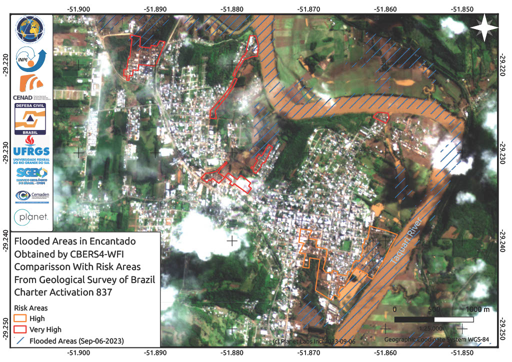
Flooded Areas in Encantado Compared with Risk Areas from a Geological Survey of Brazil
Copyright: Copyright (2023) INPE
© Planet Labs Inc. (2023)
Map produced by INPE (Instituto Nacional de Pesquisas Espaciais).
Information about the Product
Acquired: CBERS-4: 06/09/2023
PlanetScope: 06/09/2023
Source: CBERS-4 and PlanetScope
Category: Reference Map

Flooded Areas in Muçum Compared With Risk Areas From a Geological Survey of Brazil
Copyright: CBERS-4 © (2023) INPE
PlanetScope © Planet Labs Inc. (2023)
Map produced by INPE (Instituto Nacional de Pesquisas Espaciais).
Information about the Product
Acquired: CBERS: 06/09/2023
PlanetScope: 06/09/2023
Source: CBERS-4 and PlanetScope
Category: Reference Map
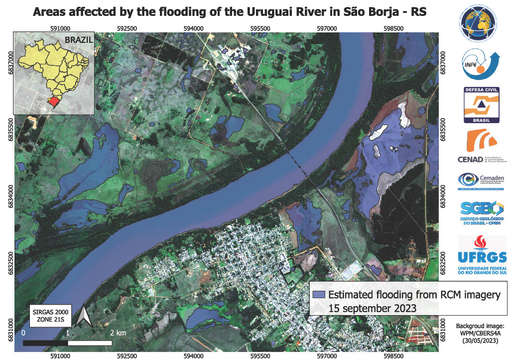
Areas affected by the flooding of the Uruguai River in São Borja, Retiro do Sul, Brazil
Copyright: RADARSAT Constellation Mission Imagery © Government of Canada (2023) - RADARSAT is an official mark of the Canadian Space Agency
Map produced by INPE (Instituto Nacional de Pesquisas Espaciais).
Information about the Product
Acquired: 16/09/2023
Source: RCM
Category: Delineation Monitoring Maps
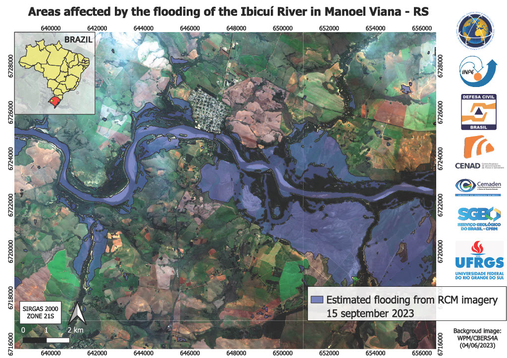
Areas affected by the flooding of the Ibicuí River in Manoel Viana, Rio Grande do Sul, Brazil
Copyright: RADARSAT Constellation Mission Imagery © Government of Canada (2023) - RADARSAT is an official mark of the Canadian Space Agency
Map produced by INPE (Instituto Nacional de Pesquisas Espaciais).
Information about the Product
Acquired: 15/09/2023
Source: RCM
Category: Delineation Map
Impacts of Flooding and Post-Flood Geomorphological Features at the Taquari River Basin, North East of Encantado, Brazil
Copyright: Includes Pleiades material © CNES (2023), Distribution Airbus DS.
Map produced by INPE (Instituto Nacional de Pesquisas Espaciais).
Information about the Product
Acquired: 11/09/2023
Source: Pleiades
Category: Delineation Map
Flood Mapping in the Guaiba Hydrographic Region and the Camaqua Watershed, Rio Grande do Sul, Brazil
Copyright: Contains modified Copernicus Sentinel data (2023)
Map produced by INPE (Instituto Nacional de Pesquisas Espaciais).
Information about the Product
Acquired: 14/09/2023
Source: Sentinel-1
Category: Delineation Monitoring Map
Areas affected by flooding in Bom Retiro do Sul, Brazil
Copyright: CBERS-4 © (2023) INPE.
RADARSAT Constellation Mission Imagery © Government of Canada (2023) - RADARSAT is an official mark of the Canadian Space Agency.
Map produced by INPE (Instituto Nacional de Pesquisas Espaciais).
Information about the Product
Acquired: CBERS-4: 30/08/2023 and 06/09/2023
RCM: 11/09/2023
Source: CBERS-4 and RCM
Category: Reference Map
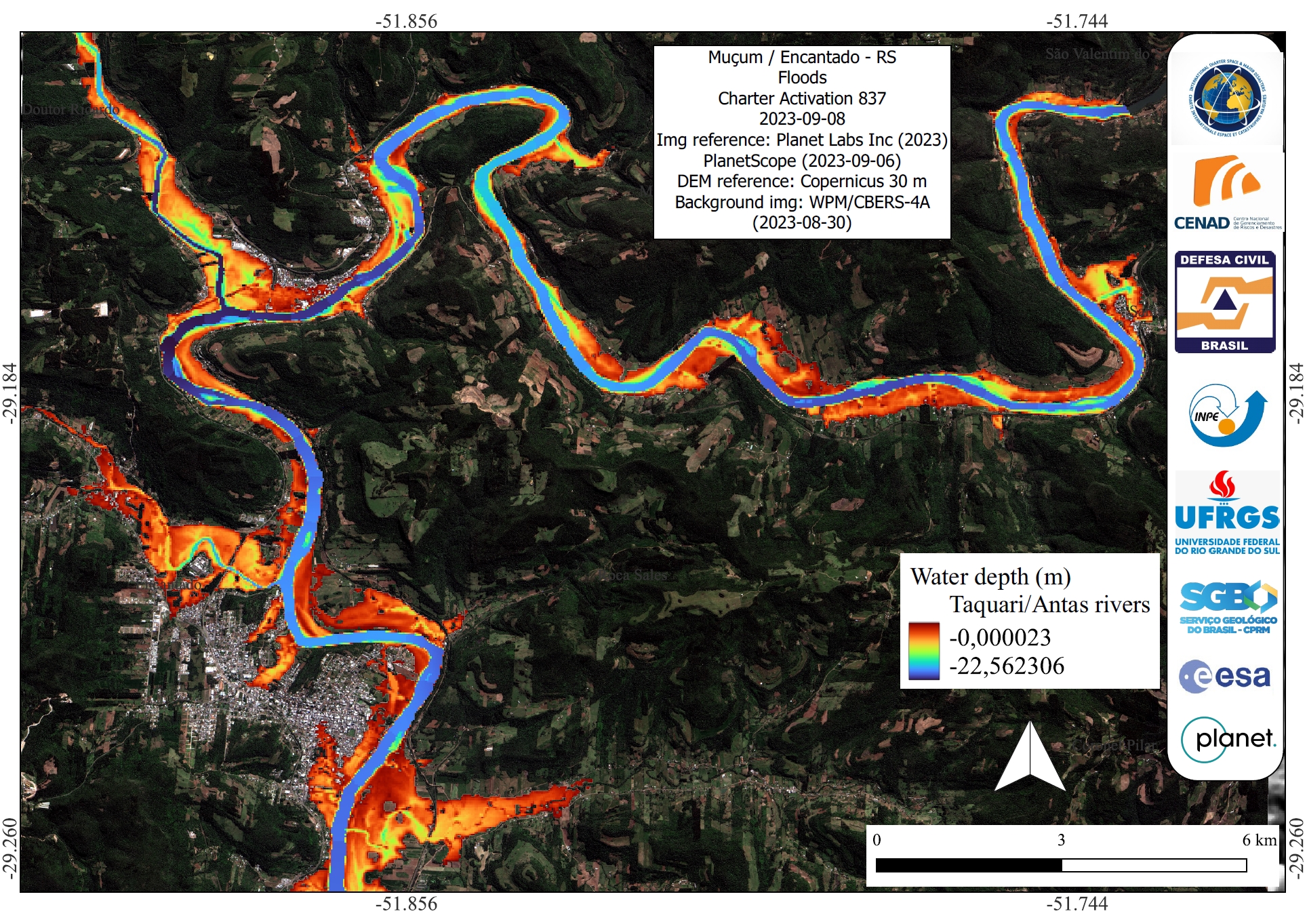
Post-Flooding Impacts and Geomorphological Features at the Taquari River Basin - Upstream of Muçum, Rio Grande do Sul, Brazil
Copyright: Includes Pleiades material © CNES (2023), Distribution Airbus DS.
Map produced by INPE (Instituto Nacional de Pesquisas Espaciais).
Information about the Product
Acquired: 11/09/2023
Source: Pleiades
Category: Delineation Map
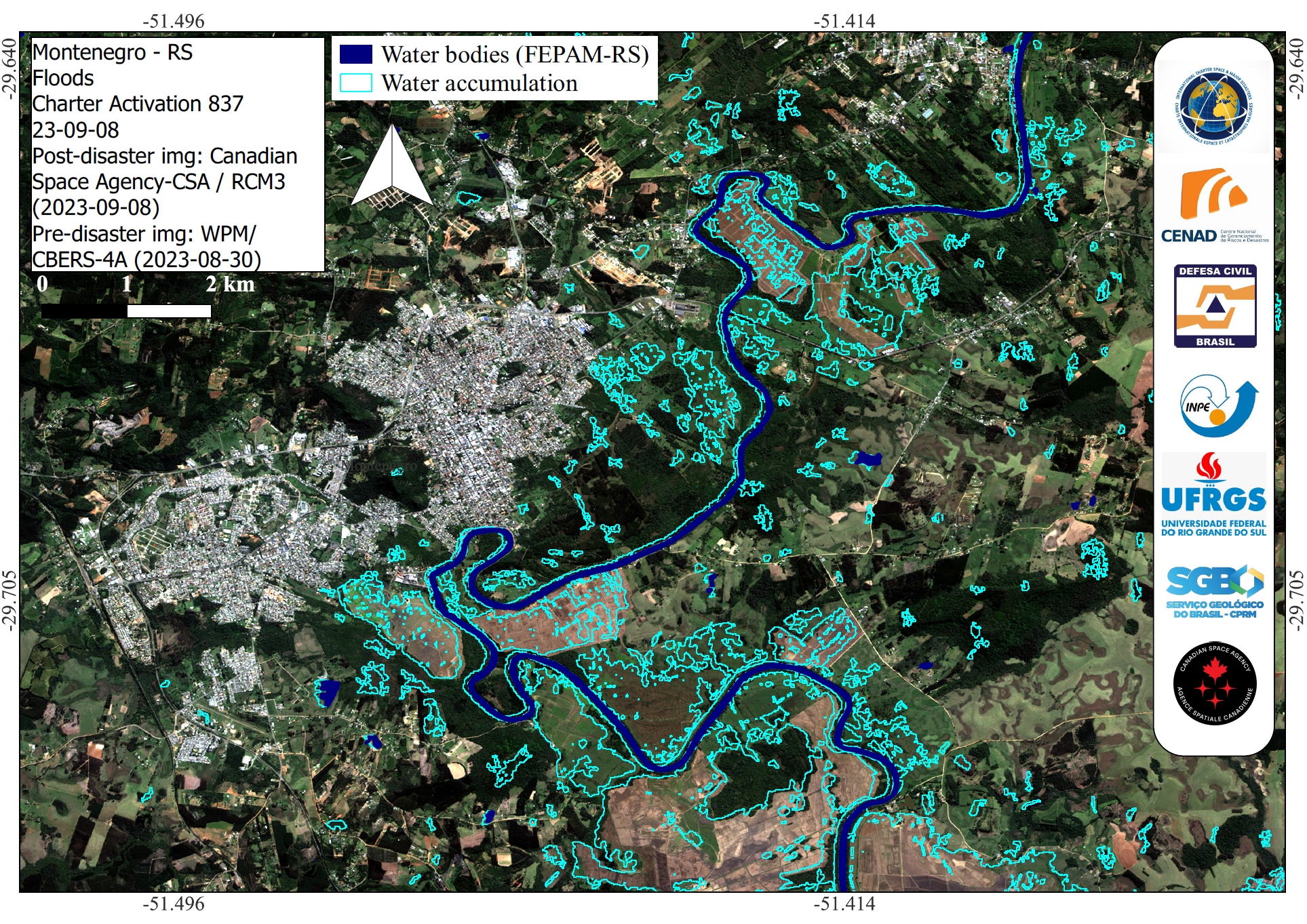
Areas affected by flooding in Montenegro, State of Rio Grande do Sul, Brazil
Copyright: RADARSAT Constellation Mission Imagery © Government of Canada (2023) - RADARSAT is an official mark of the Canadian Space Agency.
Map produced by INPE (Instituto Nacional de Pesquisas Espaciais).
Information about the Product
Acquired: 08/09/2023
Source: RCM
Category: Delineation Map
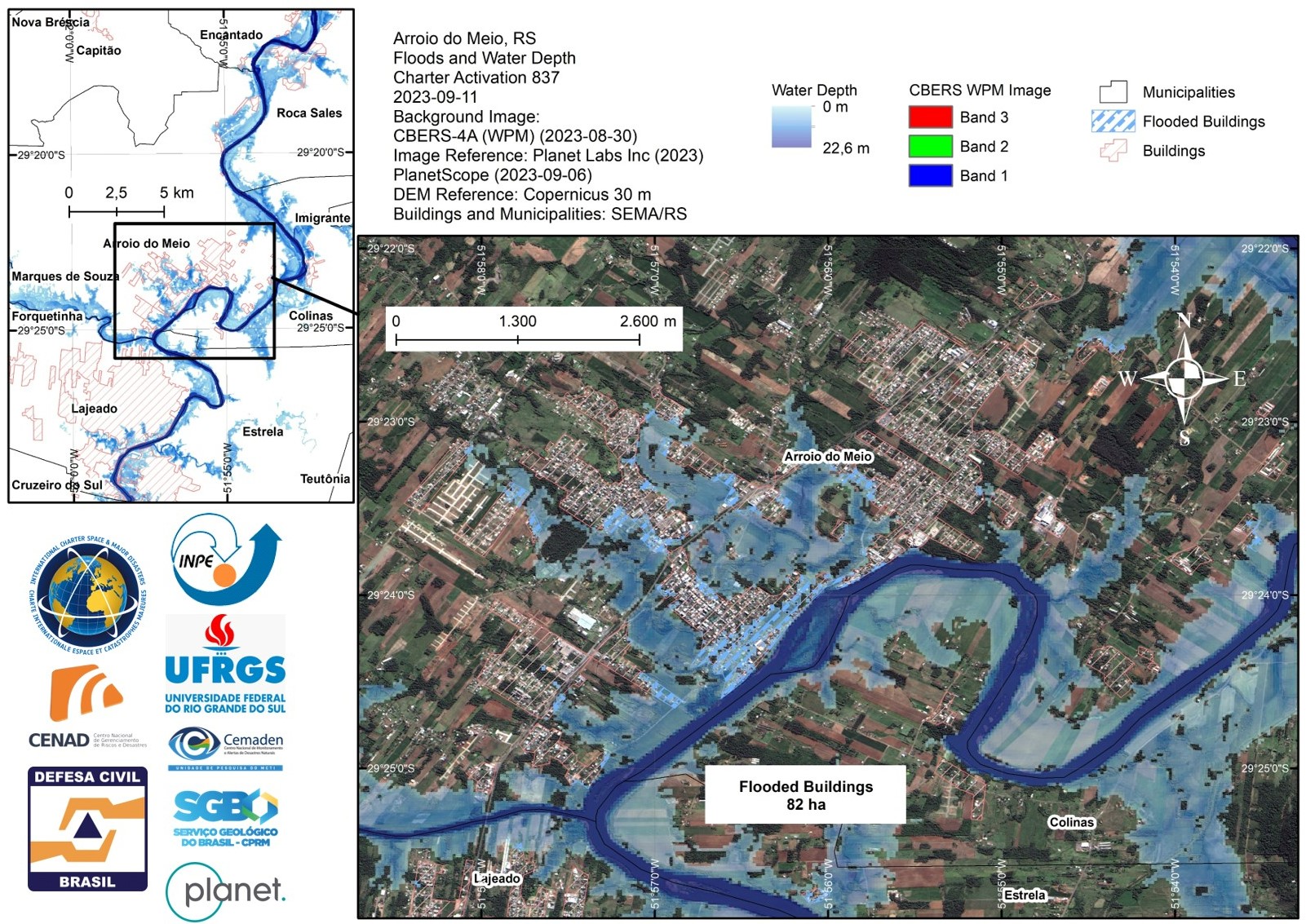
Flooded buildings and water depth in Arroio do Meio, State of Rio Grande do Sul, Brazil
Copyright: CBERS-4 © (2023) INPE
PlanetScope © Planet Labs Inc. (2023)
Map produced by INPE (Instituto Nacional de Pesquisas Espaciais).
Information about the Product
Acquired: CBERS-4: 30/08/2023
PlanetScope: 06/09/2023
Source: CBERS-4 and PlanetScope
Category: Delineation Map
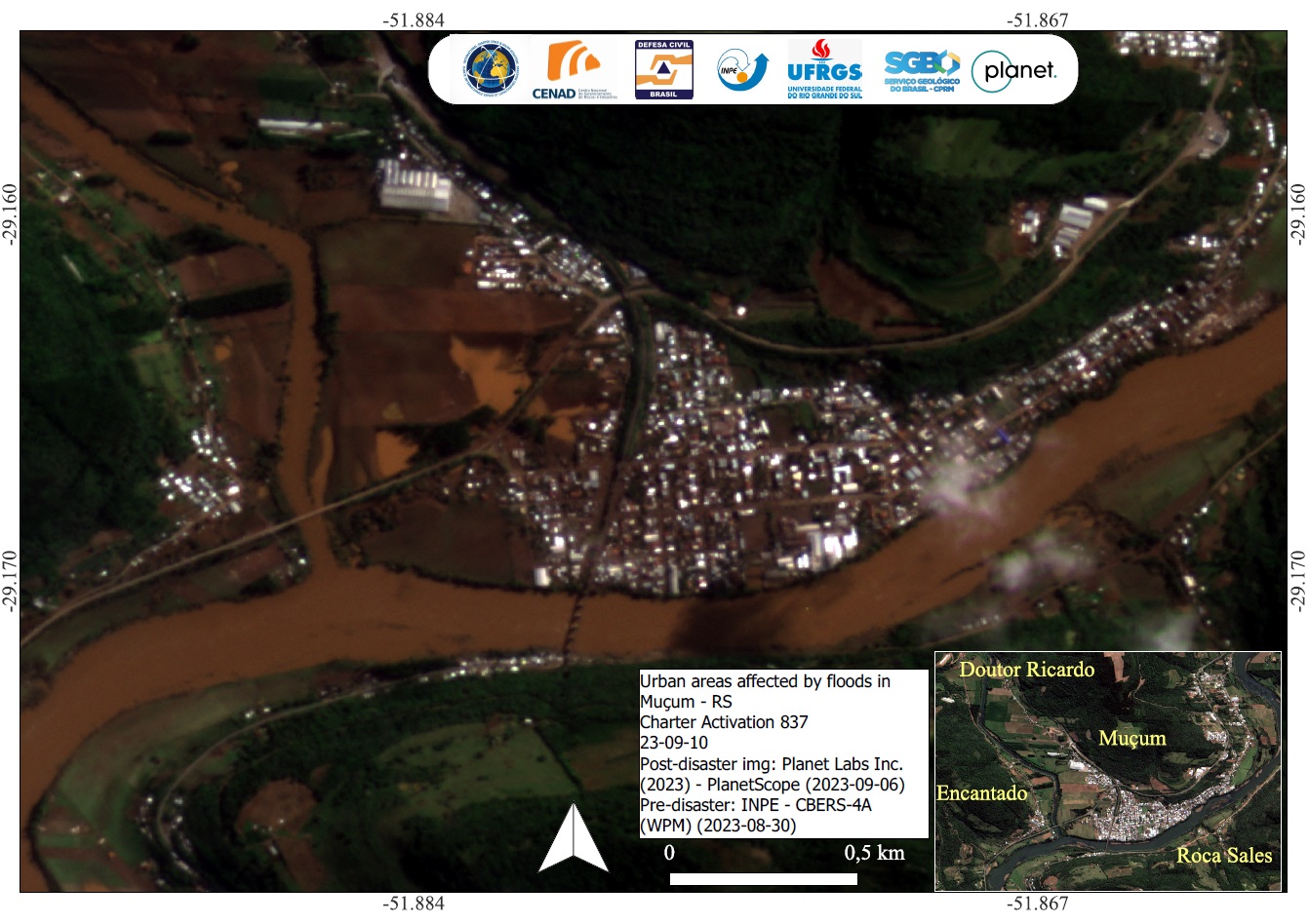
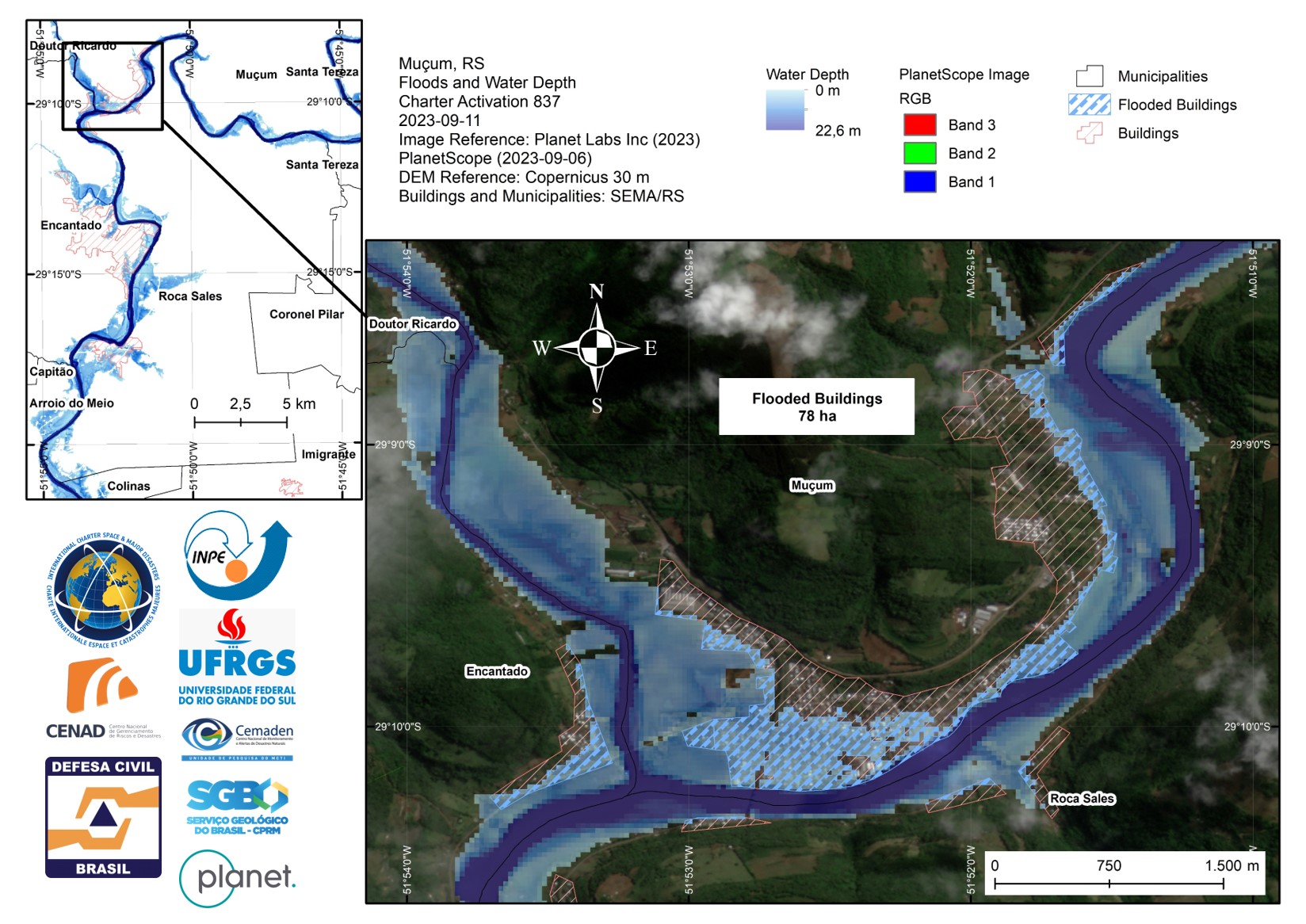
Urban areas affected by floods in Muçum, Rio Grande do Sul, Brazil
Copyright: CBERS-4 © (2023) INPE
PlanetScope © Planet Labs Inc. (2023)
Map produced by INPE (Instituto Nacional de Pesquisas Espaciais).
Information about the Product
Acquired: CBERS-4: 30/08/2023
PlanetScope: 06/09/2023
Source: CBERS-4 and PlanetScope
Category: Delineation Map
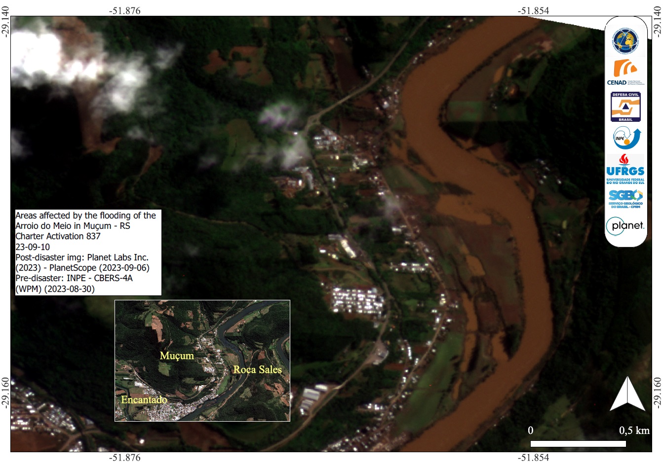
Areas affected by the flooding of the Arroio do Meio in Muçum, Rio Grande do Sul, Brazil
Copyright: CBERS-4 © (2023) INPE
PlanetScope © Planet Labs Inc. (2023)
Map produced by INPE (Instituto Nacional de Pesquisas Espaciais).
Information about the Product
Acquired: CBERS-4: 30/08/2023
PlanetScope: 06/09/2023
Source: CBERS-4 and PlanetScope
Category: Delineation Map

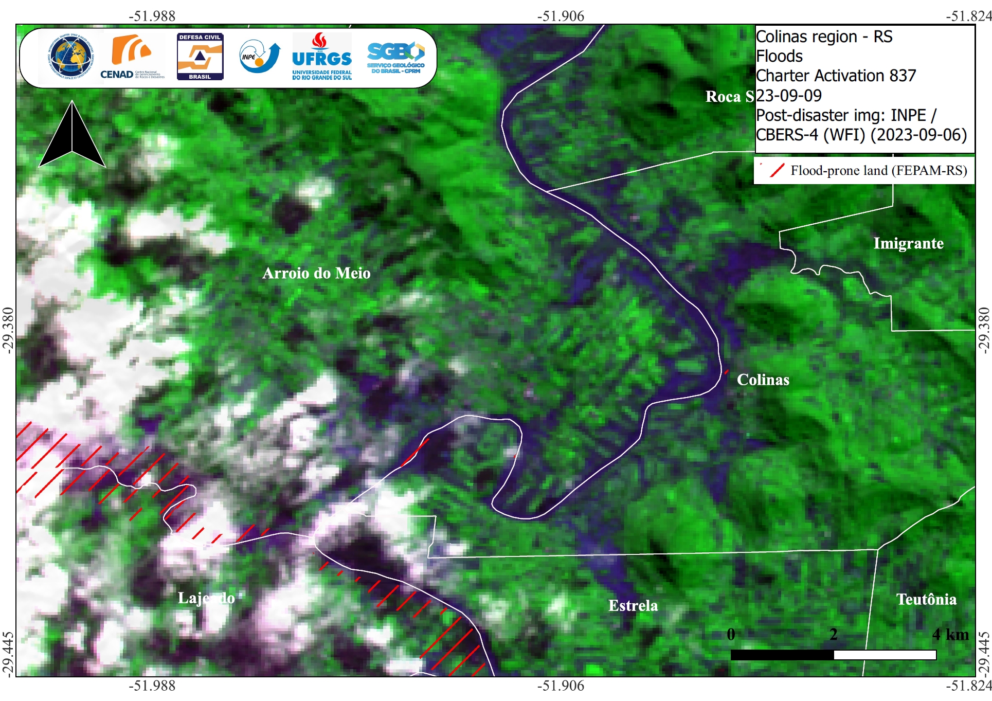
Floods near urban areas in Colinas, Rio Grande do Sul, Brazil
Copyright: CBERS-4 © (2023) INPE
PlanetScope © Planet Labs Inc. (2023)
Map produced by INPE (Instituto Nacional de Pesquisas Espaciais).
Information about the Product
Acquired: CBERS-4A: 30/08/2023
PlanetScope: 06/09/2023
Source: CBERS-4 and PlanetScope
Category: Delineation Map
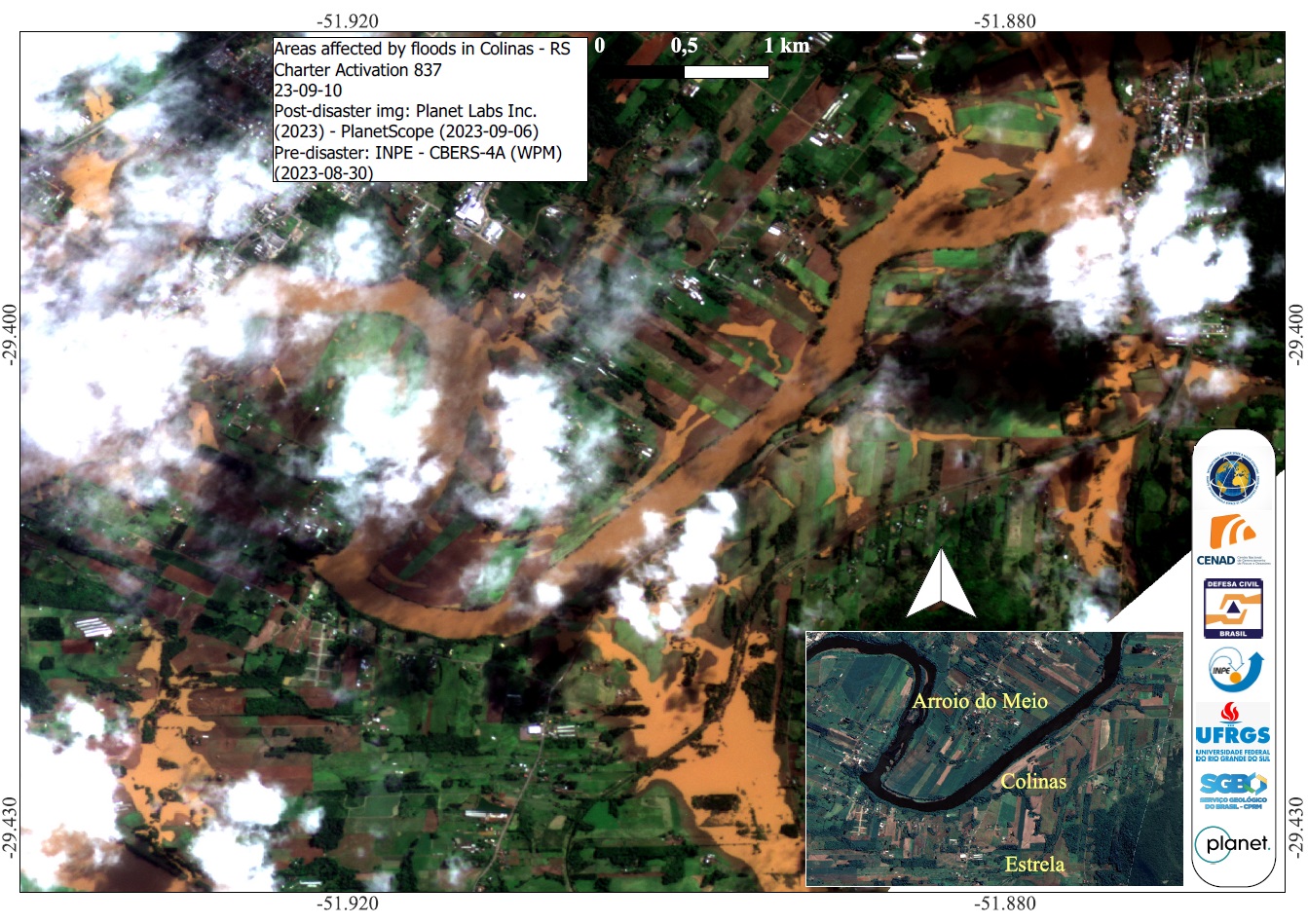
Areas affected by floods in Colinas, Rio Grande do Sul, Brazil
Copyright: CBERS-4 © (2023) INPE
PlanetScope © Planet Labs Inc. (2023)
Map produced by INPE (Instituto Nacional de Pesquisas Espaciais).
Information about the Product
Acquired: CBERS-4: 30/08/2023
PlanetScope: 06/09/2023
Source: CBERS-4 and PlanetScope
Category: Delineation Map
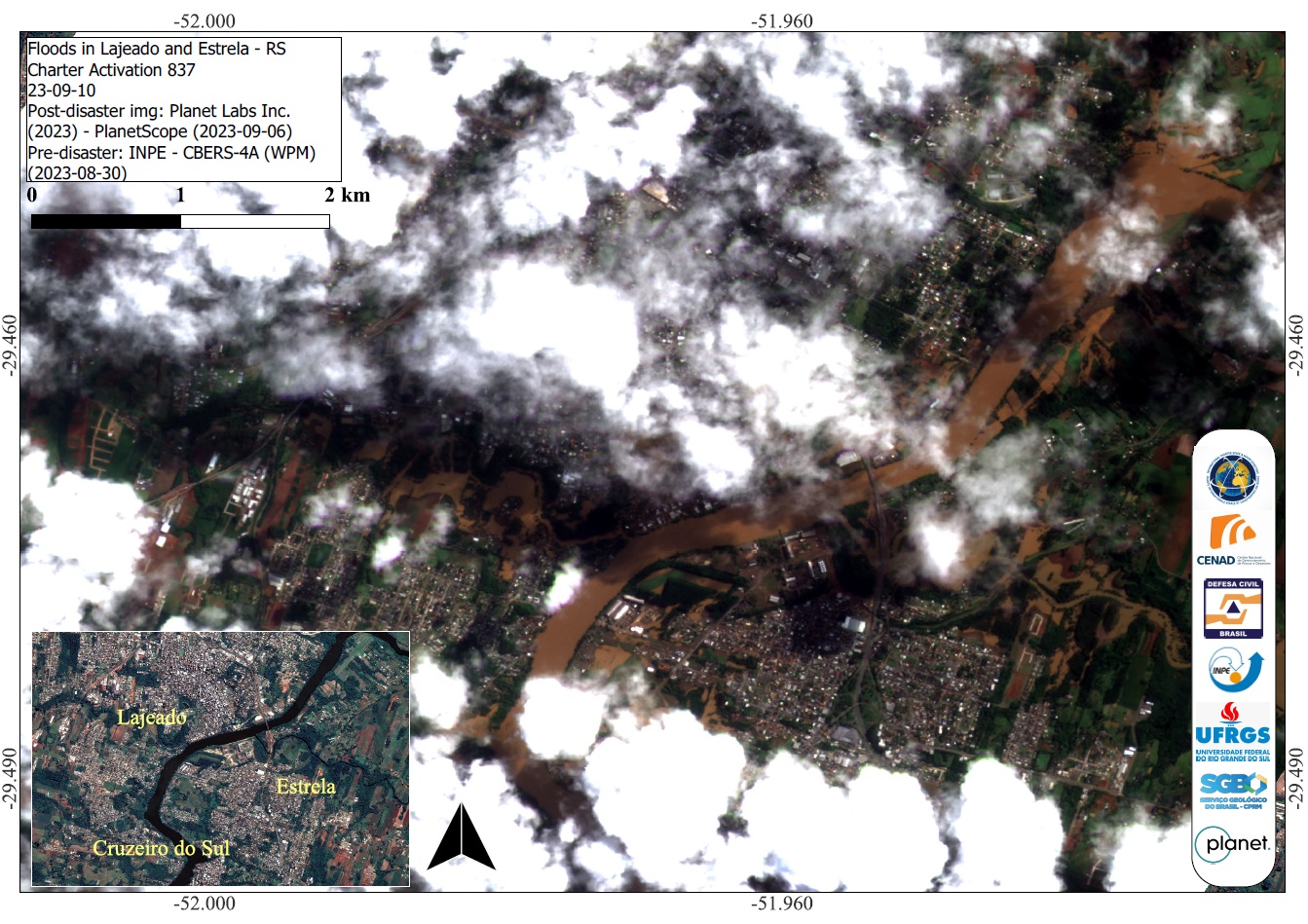
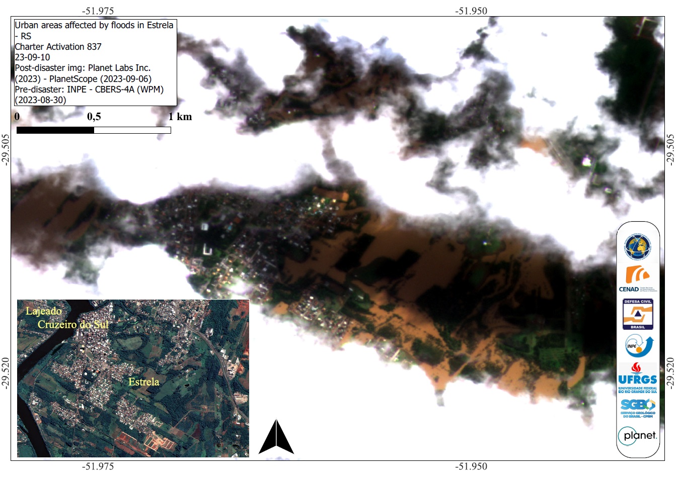
Urban areas affected by floods in Estrela, Rio Grande do Sul, Brazil
Copyright: PlanetScope © Planet Labs Inc. (2023)
CBERS-4 © (2023) INPE
Map produced by INPE (Instituto Nacional de Pesquisas Espaciais).
Information about the Product
Acquired: CBERS-4: 30/08/2023
PlanetScope: 06/09/2023
Source: CBERS-4 and PlanetScope
Category: Delineation Map

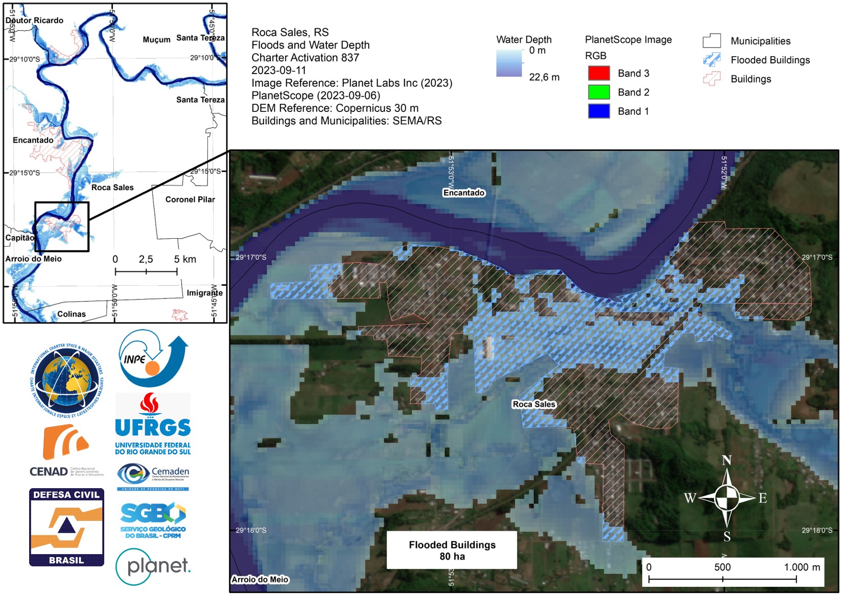
Areas affected by flooding in Roca Sales, Rio Grande do Sul, Brazil
Copyright: CBERS-4 © (2023) INPE
PlanetScope © Planet Labs Inc. (2023)
Map produced by INPE (Instituto Nacional de Pesquisas Espaciais).
Information about the Product
Acquired: CBERS-4: 30/08/2023
PlanetScope: 06/09/2023
Source: CBERS-4 and PlanetScope
Category: Delineation Map
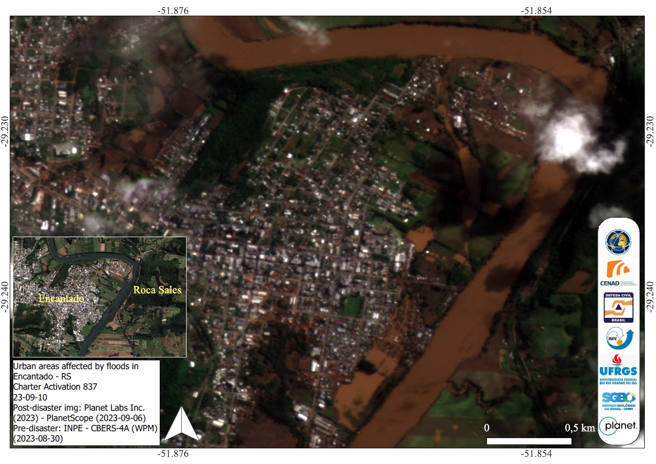
Urban areas affected by floods in Encantado, Rio Grande do Sul, Brazil
Copyright: CBERS-4 © (2023) INPE
PlanetScope © Planet Labs Inc. (2023)
Map produced by INPE (Instituto Nacional de Pesquisas Espaciais).
Information about the Product
Acquired: CBERS-4: 30/08/2023
PlanetScope: 06/09/2023
Source: CBERS-4 and PlanetScope
Category: Delineation Map
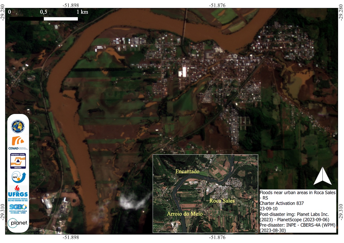
Floods near urban areas in Roca Sales, Rio Grande do Sul, Brazil
Copyright: CBERS-4 © (2023) INPE
PlanetScope © Planet Labs Inc. (2023)
Map produced by INPE (Instituto Nacional de Pesquisas Espaciais).
Information about the Product
Acquired: CBERS-4: 30/08/2023
PlanetScope: 06/09/2023
Source: CBERS-4 and PlanetScope
Category: Delineation Map
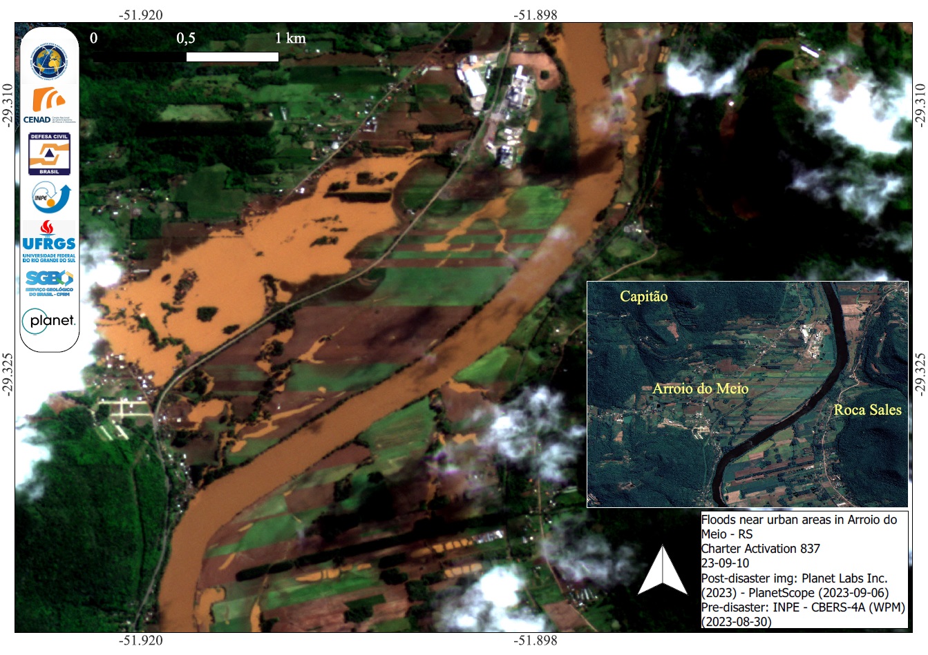
Floods near urban areas in Arroio do Meio, Rio Grande do Sul, Brazil
Copyright: CBERS-4 © (2023) INPE
PlanetScope © Planet Labs Inc. (2023)
Map produced by INPE (Instituto Nacional de Pesquisas Espaciais).
Information about the Product
Acquired: CBERS-4: 30/08/2023
PlanetScope: 06/09/2023
Source: CBERS-4 and PlanetScope
Category: Delineation Map
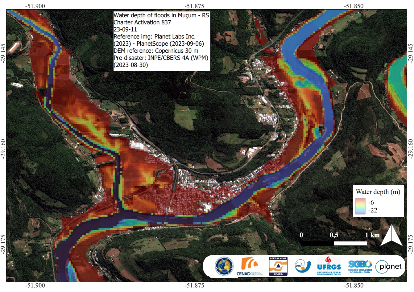
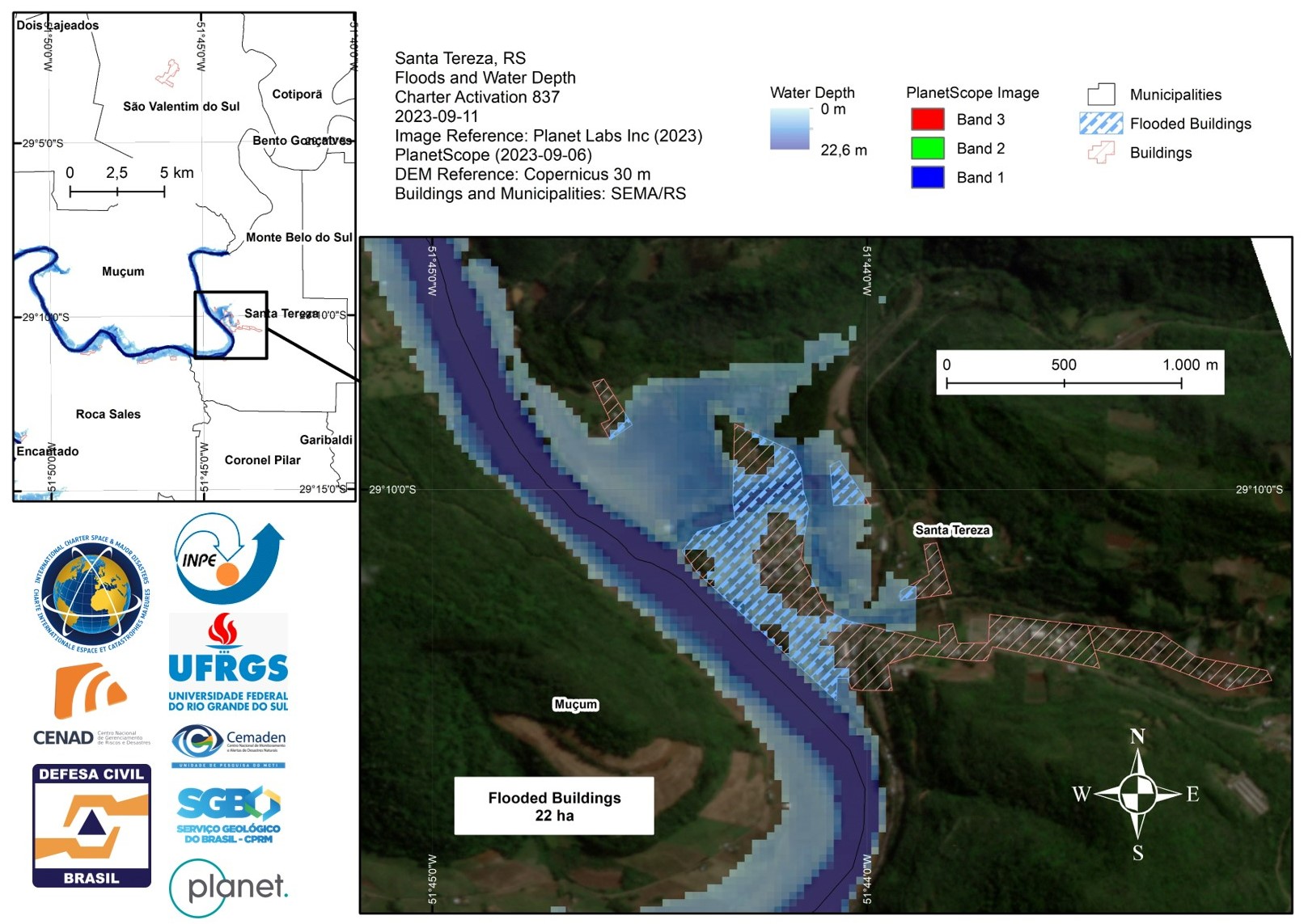
Water depth of floods in Muçum, Rio Grande do Sul, Brazil
Copyright: CBERS-4 © (2023) INPE
PlanetScope © Planet Labs Inc. (2023)
Map produced by INPE (Instituto Nacional de Pesquisas Espaciais).
Information about the Product
Acquired: PlanetScope: 06/09/2023
CBERS-4: 30/08/2023
Source: CBERS-4, PlanetScope
Category: Delineation Monitoring Maps
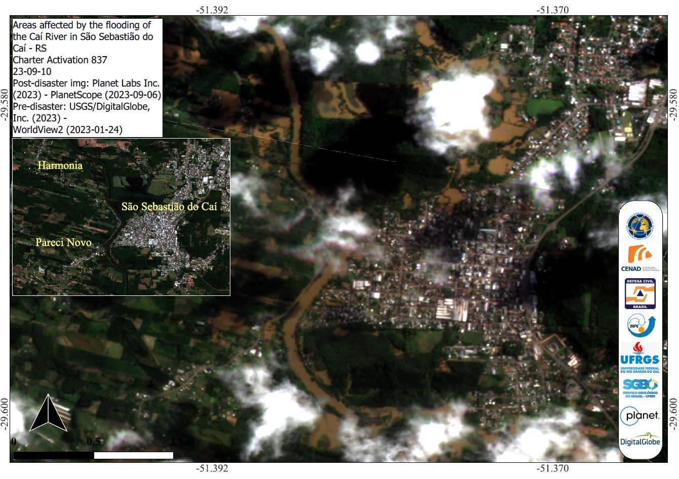
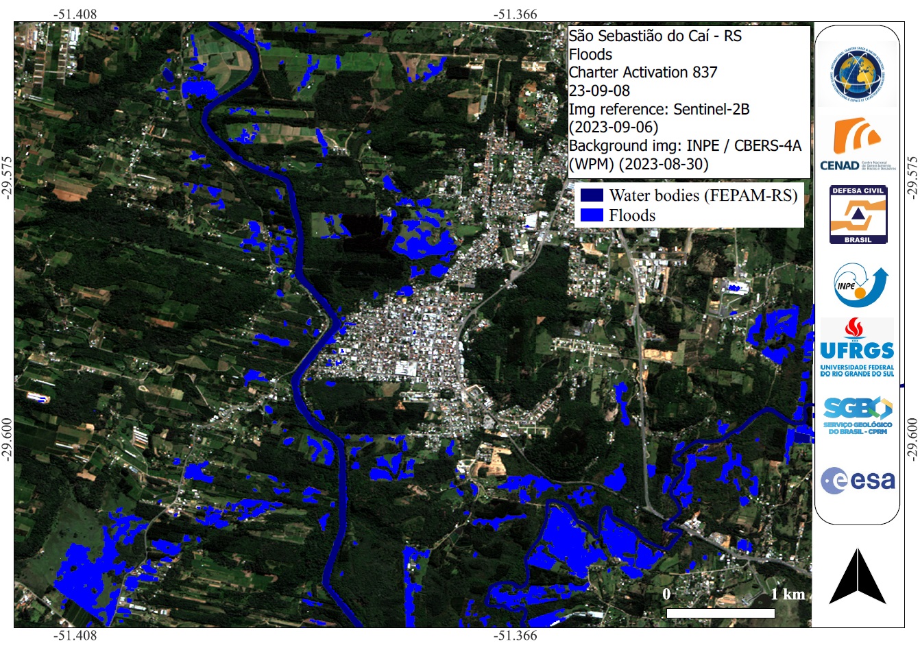
Areas affected by the flooding of the Caí River in São Sebastião do Caí, Rio Grande do Sul, Brazil
Copyright: WorldView-2 © (2023) DigitalGlobe, Inc., Longmont CO USA 80503.
DigitalGlobe and the DigitalGlobe logos are trademarks of DigitalGlobe, Inc. The use and/or dissemination of this data and/or of any product in any way derived there from are restricted. Unauthorized use and/or dissemination is prohibited.
PlanetScope © Planet Labs Inc. (2023)
Map produced by INPE (Instituto Nacional de Pesquisas Espaciais).
Information about the Product
Acquired: WorldView-2: 24/01/2023
PlanetScope: 06/09/2023
Source: WorldView-2 and PlanetScope
Category: Reference Map
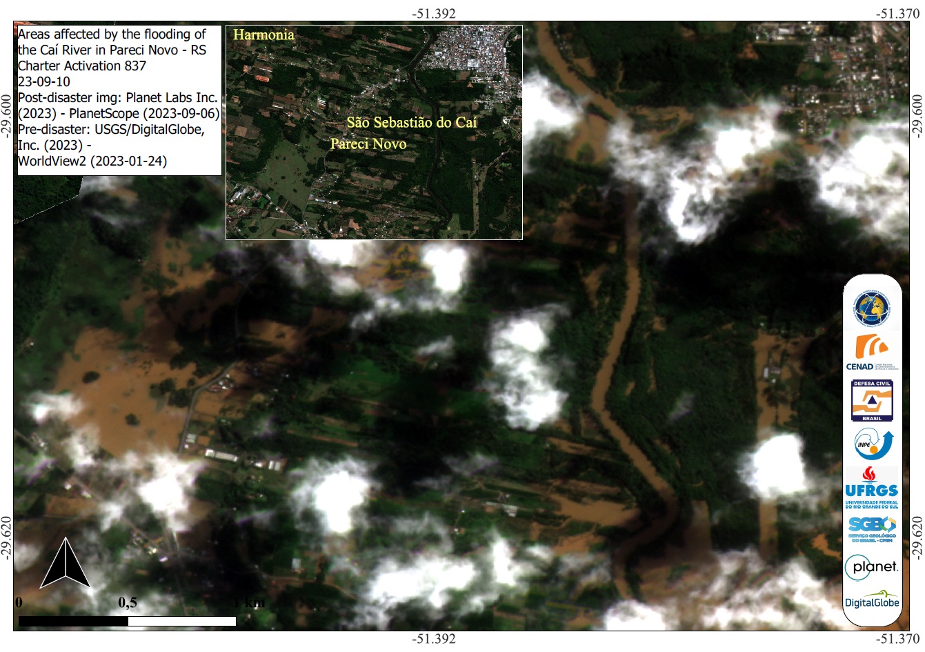
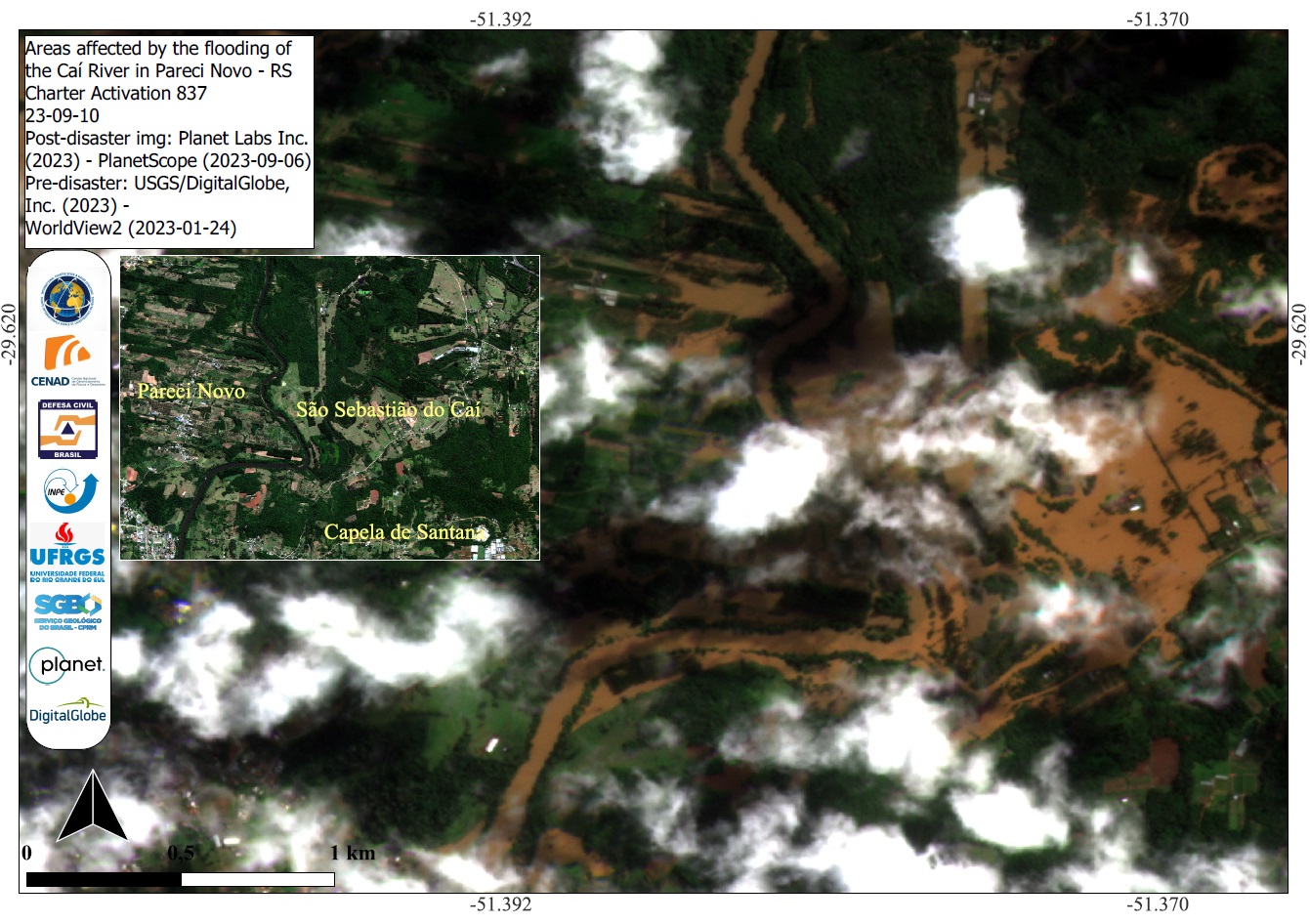
Areas affected by the flooding of the Caí River in Pareci Novo, Rio Grande do Sul, Brazil
Copyright: WorldView-2 © (2023) DigitalGlobe, Inc., Longmont CO USA 80503.
DigitalGlobe and the DigitalGlobe logos are trademarks of DigitalGlobe, Inc. The use and/or dissemination of this data and/or of any product in any way derived there from are restricted. Unauthorized use and/or dissemination is prohibited.
PlanetScope © Planet Labs Inc. (2023)
Map produced by INPE (Instituto Nacional de Pesquisas Espaciais).
Information about the Product
Acquired: Worldview-2: 24/01/2023
PlanetScope: 06/09/2023
Source: WorldView-2 and PlanetScope
Category: Delineation Map
Affected areas by flooding in Pareci Novo and São Sebastião do Caí, Rio Grande do Sul, Brazil
Copyright: WorldView-2 © (2023) DigitalGlobe, Inc., Longmont CO USA 80503.
DigitalGlobe and the DigitalGlobe logos are trademarks of DigitalGlobe, Inc. The use and/or dissemination of this data and/or of any product in any way derived there from are restricted. Unauthorized use and/or dissemination is prohibited.
PlanetScope © Planet Labs Inc. (2023)
Map produced by INPE (Instituto Nacional de Pesquisas Espaciais).
Information about the Product
Acquired: WorldView-2: 24/01/2023
PlanetScope: 06/09/2023
Source: WorldView-2 and PlanetScope
Category: Delineation Map
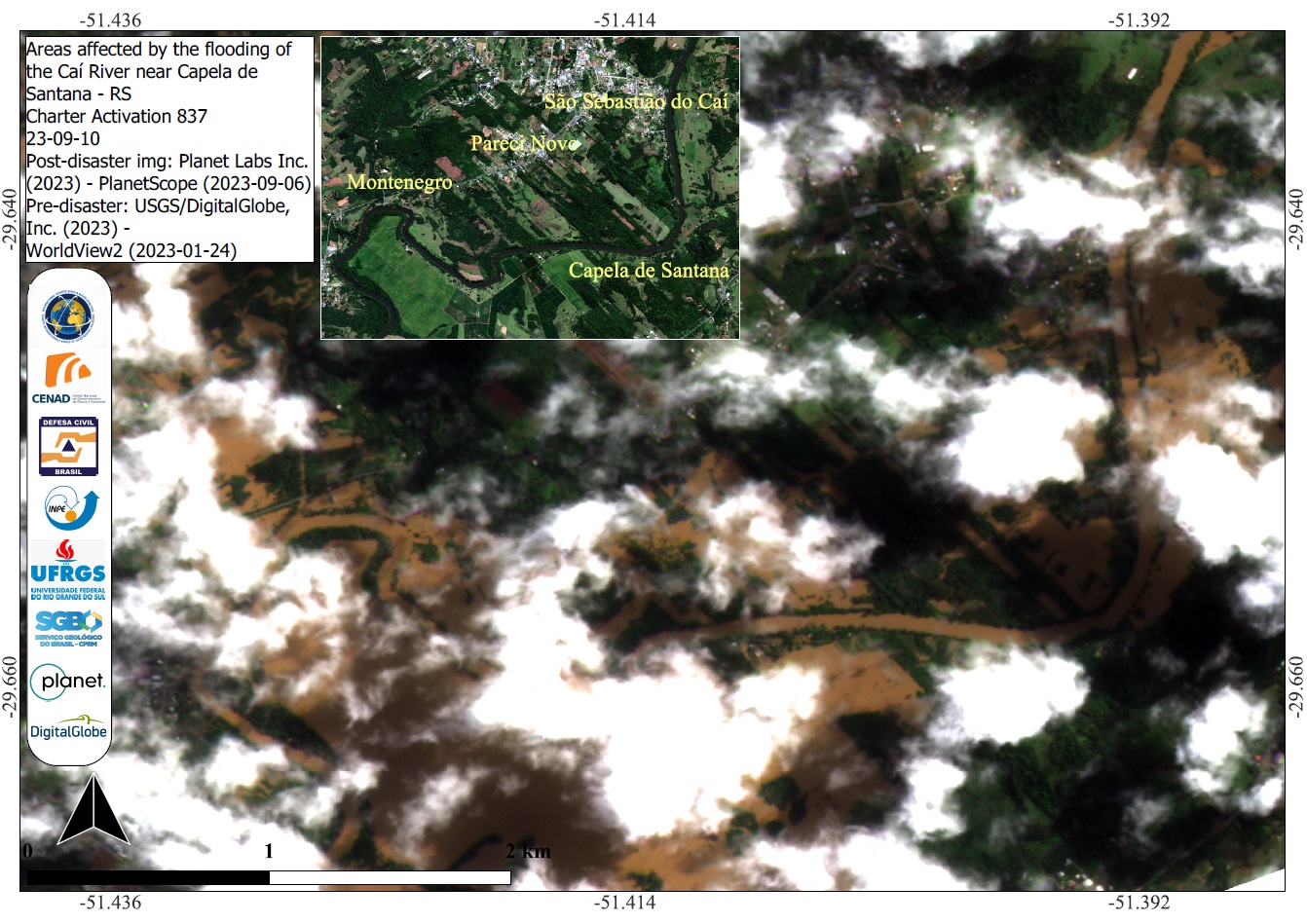
Areas affected by the flooding of the Caí River near Capela de Santana, Rio Grande do Sul, Brazil
Copyright: WorldView-2 © (2023) DigitalGlobe, Inc., Longmont CO USA 80503.
DigitalGlobe and the DigitalGlobe logos are trademarks of DigitalGlobe, Inc. The use and/or dissemination of this data and/or of any product in any way derived there from are restricted. Unauthorized use and/or dissemination is prohibited.
PlanetScope © Planet Labs Inc. (2023)
Map produced by INPE (Instituto Nacional de Pesquisas Espaciais).
Information about the Product
Acquired: WorldView-2: 24/01/2023
PlanetScope: 06/09/2023
Source: WorldView-2 and PlanetScope
Category: Delineation Map
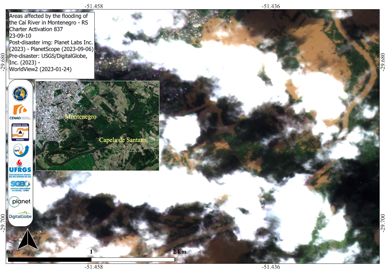
Areas affected by the flooding of the Caí River in Montenegro, Rio Grande do Sul, Brazil
Copyright: WorldView-2 © (2023) DigitalGlobe, Inc., Longmont CO USA 80503.
DigitalGlobe and the DigitalGlobe logos are trademarks of DigitalGlobe, Inc. The use and/or dissemination of this data and/or of any product in any way derived there from are restricted. Unauthorized use and/or dissemination is prohibited.
PlanetScope © Planet Labs Inc. (2023)
Map produced by INPE (Instituto Nacional de Pesquisas Espaciais)
Information about the Product
Acquired: WorldView-2: 24/01/2023
PlanetScope: 06/09/2023
Source: WorldView-2 and PlanetScope
Category: Delineation Map
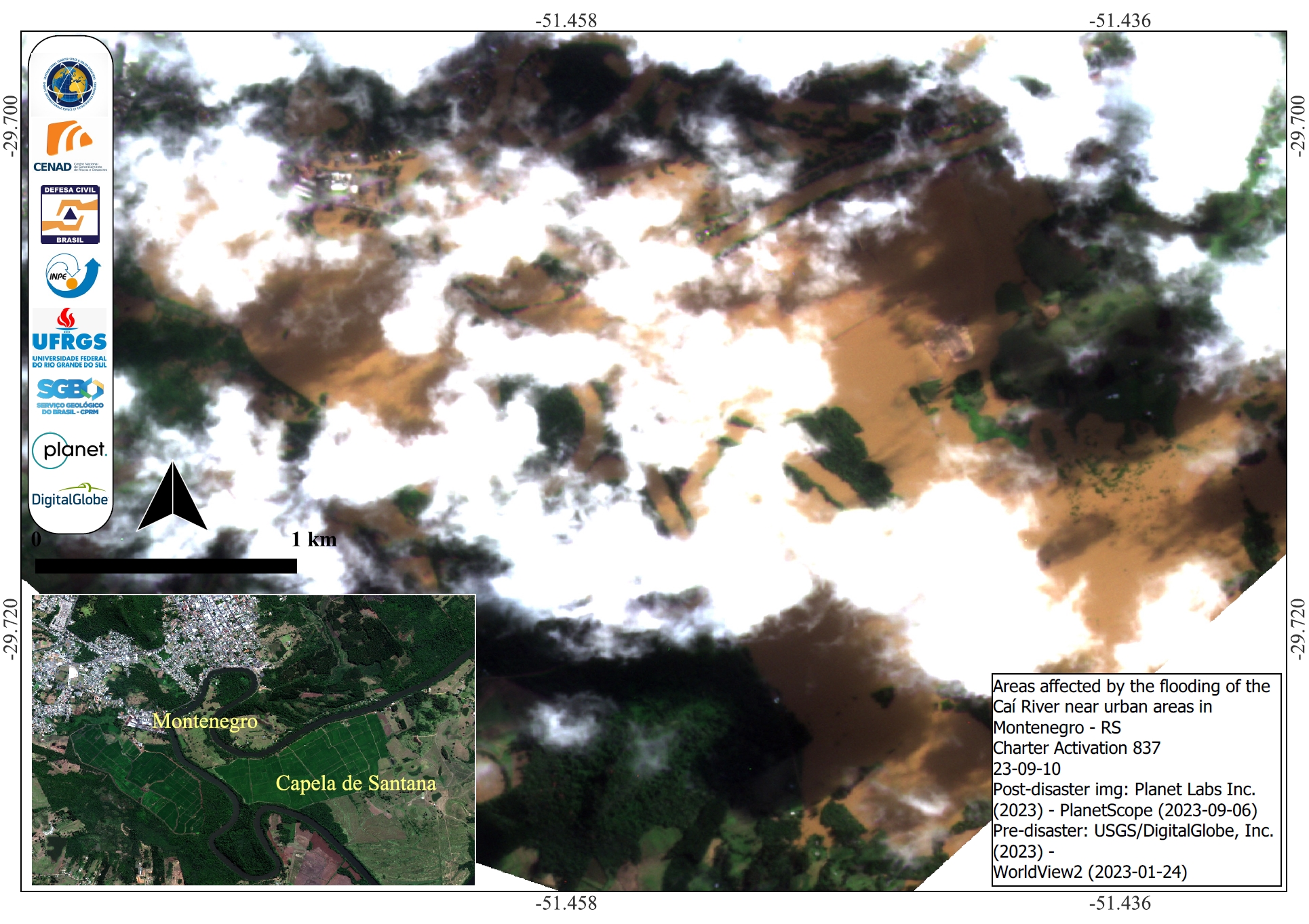
Areas affected by the flooding of the Caí River near urban areas in Montenegro, Rio Grande do Sul, Brazil
Copyright: WorldView-2 © (2023) DigitalGlobe, Inc., Longmont CO USA 80503.
DigitalGlobe and the DigitalGlobe logos are trademarks of DigitalGlobe, Inc. The use and/or dissemination of this data and/or of any product in any way derived there from are restricted. Unauthorized use and/or dissemination is prohibited.
PlanetScope © Planet Labs Inc. (2023)
Map produced by INPE (Instituto Nacional de Pesquisas Espaciais)
Information about the Product
Acquired: WorldView-2: 24/01/2023
PlanetScope: 06/09/2023
Source: WorldView-2 and PlanetScope
Category: Delineation Map
Areas affected by the flooding of the Caí River near Montenegro and Capela de Santana, Rio Grande do Sul, Brazil
Copyright: WorldView-2 © (2023) DigitalGlobe, Inc., Longmont CO USA 80503.
DigitalGlobe and the DigitalGlobe logos are trademarks of DigitalGlobe, Inc. The use and/or dissemination of this data and/or of any product in any way derived there from are restricted. Unauthorized use and/or dissemination is prohibited.
PlanetScope © Planet Labs Inc. (2023)
Map produced by INPE (Instituto Nacional de Pesquisas Espaciais)
Information about the Product
Acquired: WorldView-2: 24/01/2023
PlanetScope: 06/09/2023
Source: WorldView-2 and PlanetScope
Category: Delineation Map
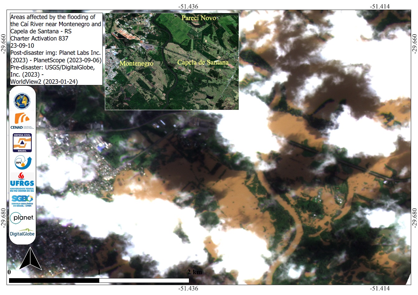
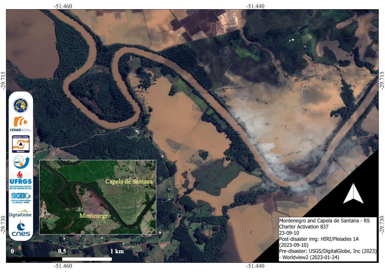
Areas affected by Flooding in Montenegro and Capela de Sanatana, Rio Grande do Sul, Brazil
Copyright: WorldView-2 © (2023) DigitalGlobe, Inc., Longmont CO USA 80503.
DigitalGlobe and the DigitalGlobe logos are trademarks of DigitalGlobe, Inc. The use and/or dissemination of this data and/or of any product in any way derived there from are restricted. Unauthorized use and/or dissemination is prohibited.
Includes Pleiades material © CNES (2023), Distribution Airbus DS.
Map produced by INPE (Instituto Nacional de Pesquisas Espaciais)
Information about the Product
Acquired: WorldView-2: 24/01/2023
Pleiades: 10/09/2023
Source: WorldView-2 and Pleiades
Category: Delineation Map
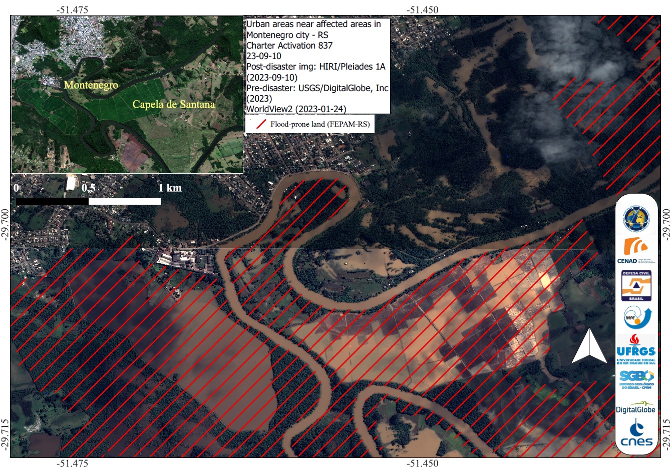
Urban areas affected by flooding in Montenegro city, Rio Grande do Sul, Brazil
Copyright: WorldView-2 © (2023) DigitalGlobe, Inc., Longmont CO USA 80503.
DigitalGlobe and the DigitalGlobe logos are trademarks of DigitalGlobe, Inc. The use and/or dissemination of this data and/or of any product in any way derived there from are restricted. Unauthorized use and/or dissemination is prohibited.
Includes Pleiades material © CNES (2023), Distribution Airbus DS.
Map produced by INPE (Instituto Nacional de Pesquisas Espaciais).
Information about the Product
Acquired: WorldView-2: 24/01/2023
Pleiades: 10/09/2023
Source: WorldView-2 and Pleiades
Category: Delineation Map
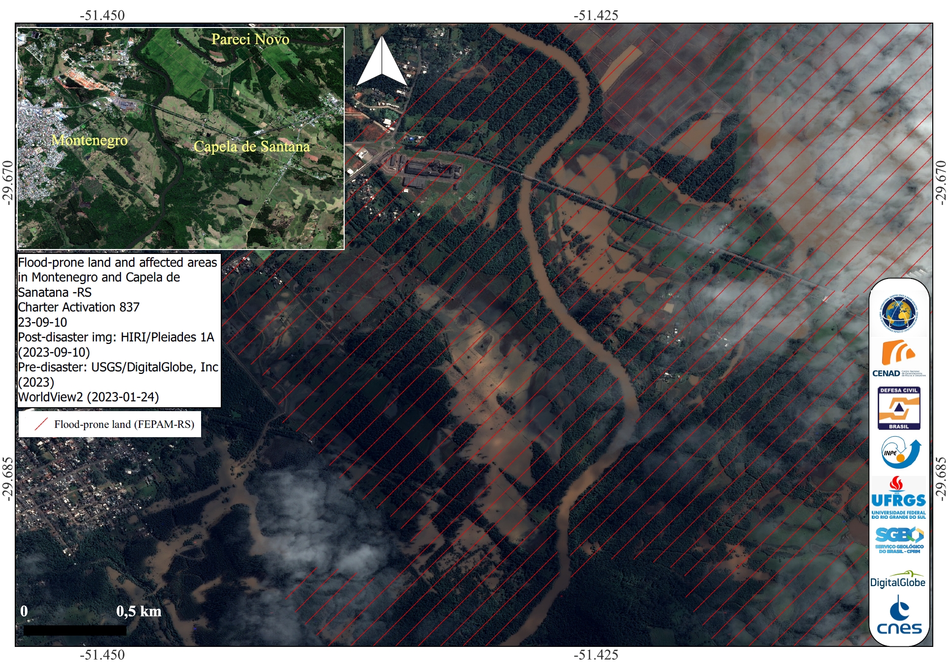
Areas affected by flooding in Montenegro and Capela de Santana, Rio Grande do Sul, Brazil
Copyright: WorldView-2 © (2023) DigitalGlobe, Inc., Longmont CO USA 80503.
DigitalGlobe and the DigitalGlobe logos are trademarks of DigitalGlobe, Inc. The use and/or dissemination of this data and/or of any product in any way derived there from are restricted. Unauthorized use and/or dissemination is prohibited.
Includes Pleiades material © CNES (2023), Distribution Airbus DS.
Map produced by INPE (Instituto Nacional de Pesquisas Espaciais).
Information about the Product
Acquired: WorldView-2: 24/01/2023
Pleiades: 10/09/2023
Source: WorldView-2 and Pleiades
Category: Delineation Map
Areas affected by Flooding in São Sebastião do Caí, Rio Grande do Sul, Brazil
Copyright: CBERS-4 © (2023) INPE
Contains modified Copernicus Sentinel data (2023)
Map produced by INPE (Instituto Nacional de Pesquisas Espaciais).
Information about the Product
Acquired: CBERS-4: 30/08/2023
Sentinel-2: 06/09/2023
Source: CBERS-4 and Sentinel-2
Category: Delineation Map
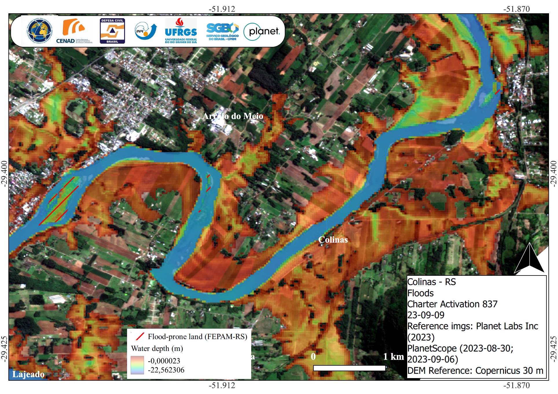
Water Depth in Areas affected by Flooding in Colinas, State of Rio Grande do Sul, Brazil
Copyright: © Planet Labs Inc. (2023)
Map produced by INPE (Instituto Nacional de Pesquisas Espaciais).
Information about the Product
Acquired: 30/08/2023 and 06/09/2023
Source: PlanetScope
Category: Delineation Map
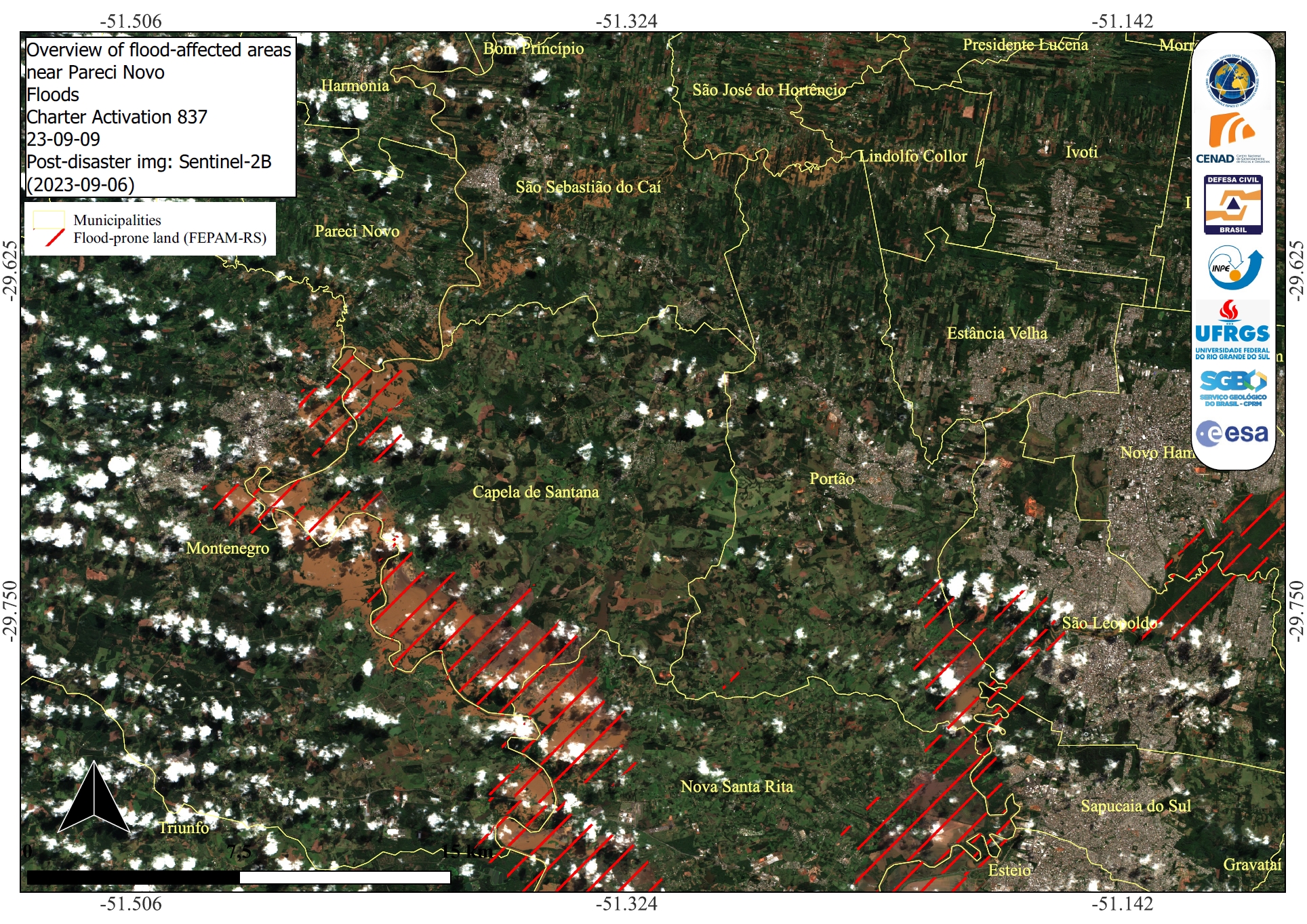
Areas affected by flooding around Pareci Novo, State of Rio Grande do Sul, Brazil
Copyright: Contains modified Copernicus Sentinel data (2023)
Map produced by INPE (Instituto Nacional de Pesquisas Espaciais).
Information about the Product
Acquired: 06/09/2023
Source: Sentinel-2
Category: Delineation Map
Areas affected by flooding in Montenegro, State of Rio Grande do Sul, Brazil
Copyright: CBERS-4A © (2023) INPE and CRESDA
RADARSAT Constellation Mission Imagery © Government of Canada (2023) - RADARSAT is an official mark of the Canadian Space Agency.
Map produced by INPE (Instituto Nacional de Pesquisas Espaciais)
Information about the Product
Acquired: CBERS-4: 30/08/2023
RCM: 08/09/2023
Source: CBERS-4 and RCM
Category: Delineation Map
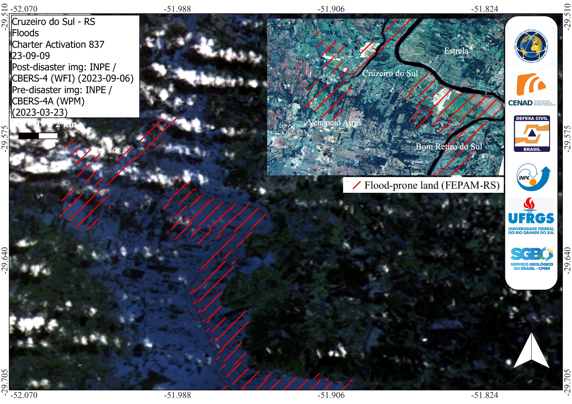
Areas affected by flooding in Cruzeiro do Sul, State of Rio Grande do Sul, Brazil
Copyright: © (2023) INPE and CRESDA
Map produced by INPE (Instituto Nacional de Pesquisas Espaciais).
Information about the Product
Acquired: CBERS-4A: 23/03/2023
CBERS-4: 06/09/2023
Source: CBERS-4 and CBERS-4A
Category: Reference Map
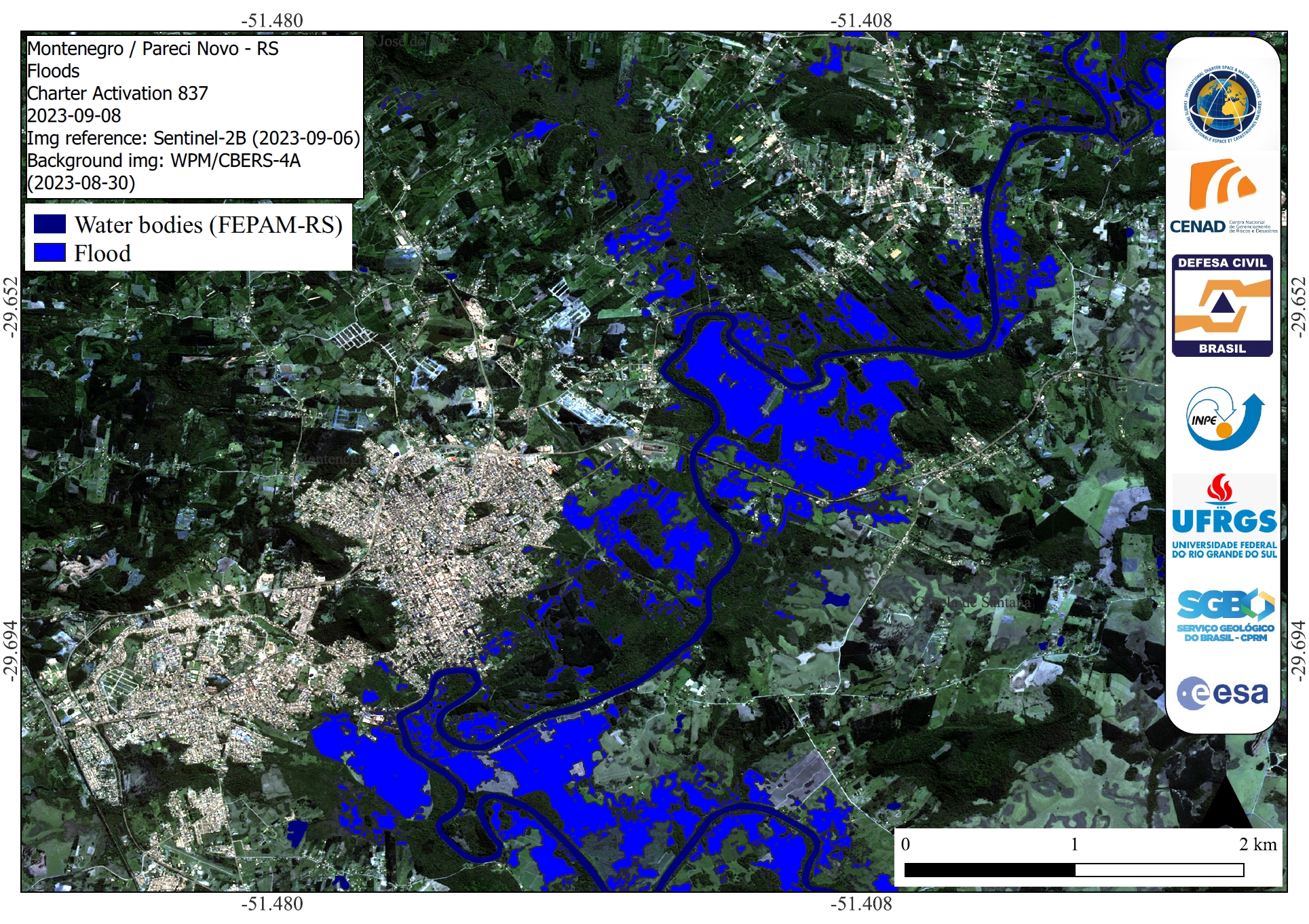
Areas affected by flooding in Montenegro and Pareci Novo, State of Rio Grande do Sul, Brazil
Copyright: CBERS-4 © (2023) INPE and CRESDA
Contains modified Copernicus Sentinel data (2023)
Map produced by INPE (Instituto Nacional de Pesquisas Espaciais)
Information about the Product
Acquired: CBERS-4: 30/08/2023
Sentinel-2: 06/09/2023
Source: CBERS-4 and Sentinel-2
Category: Delineation Map
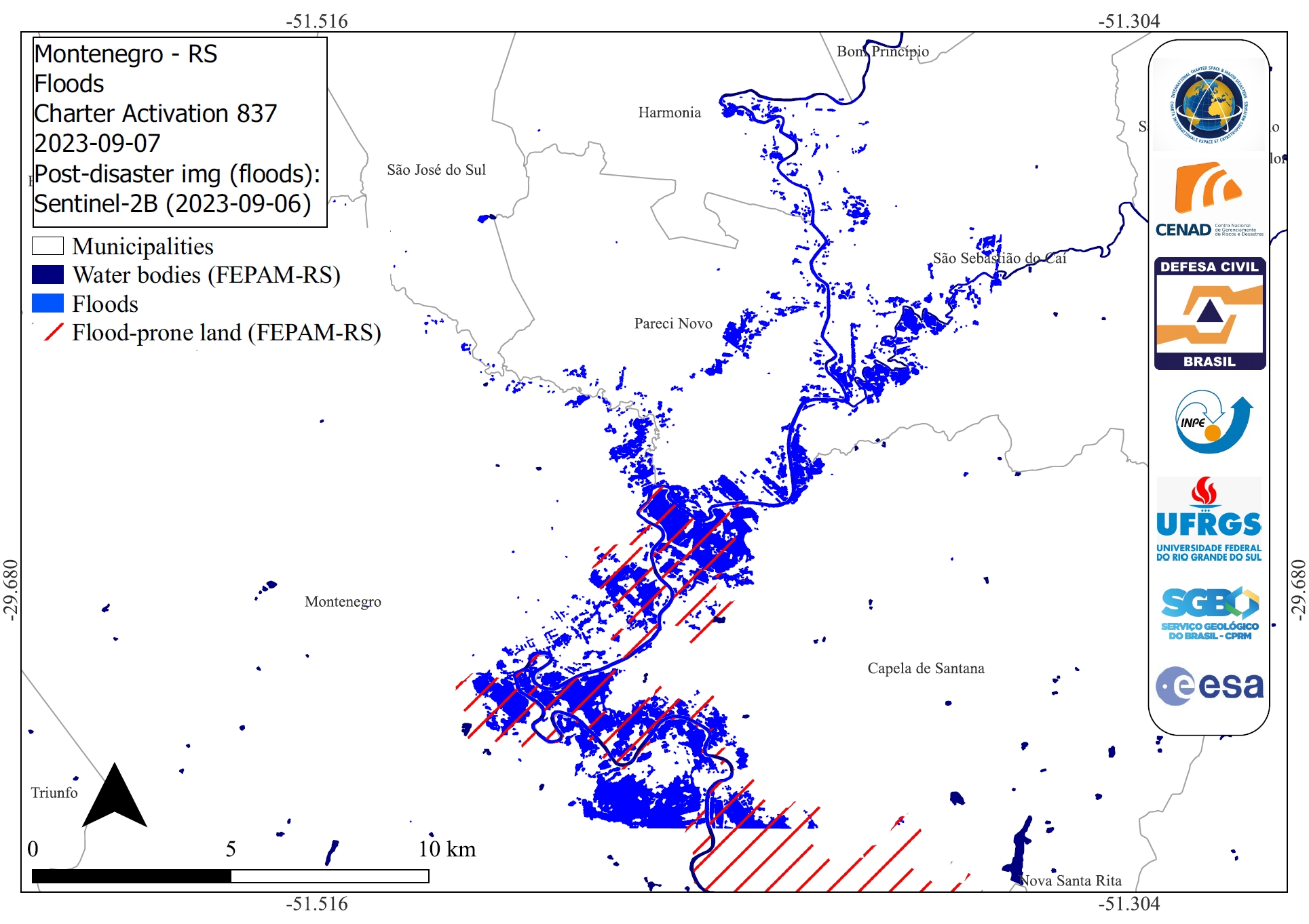
Areas affected by flooding in and around Montenegro, State of Rio Grande do Sul, Brazil
Copyright: Contains modified Copernicus Sentinel data (2023)
Map produced by INPE (Instituto Nacional de Pesquisas Espaciais).
Information about the Product
Acquired: 06/09/2023
Source: Sentinel-2
Category: Delineation Map
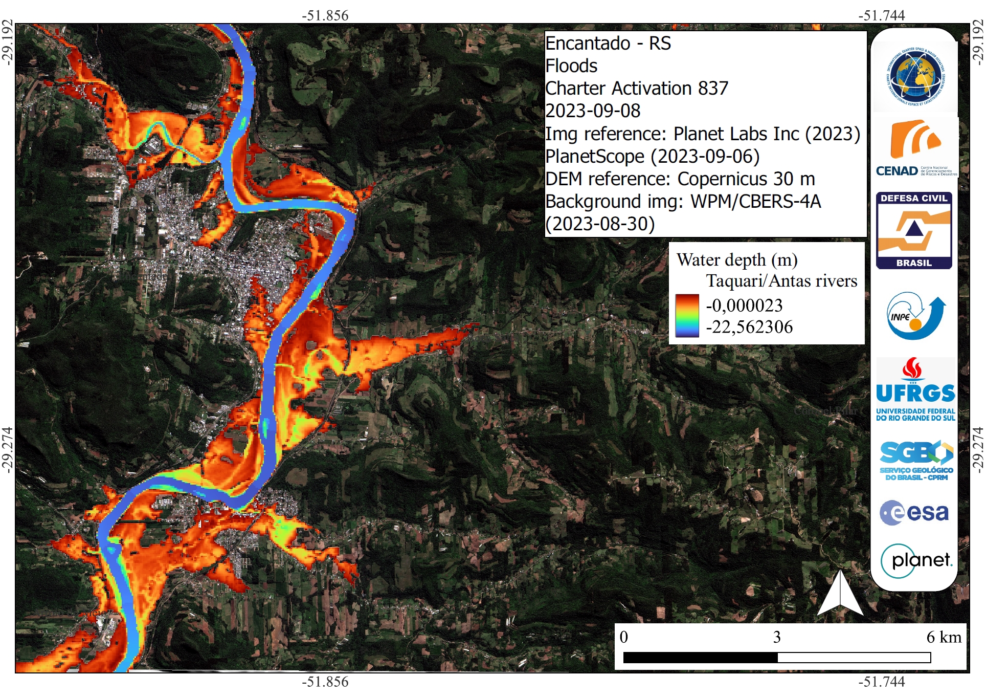
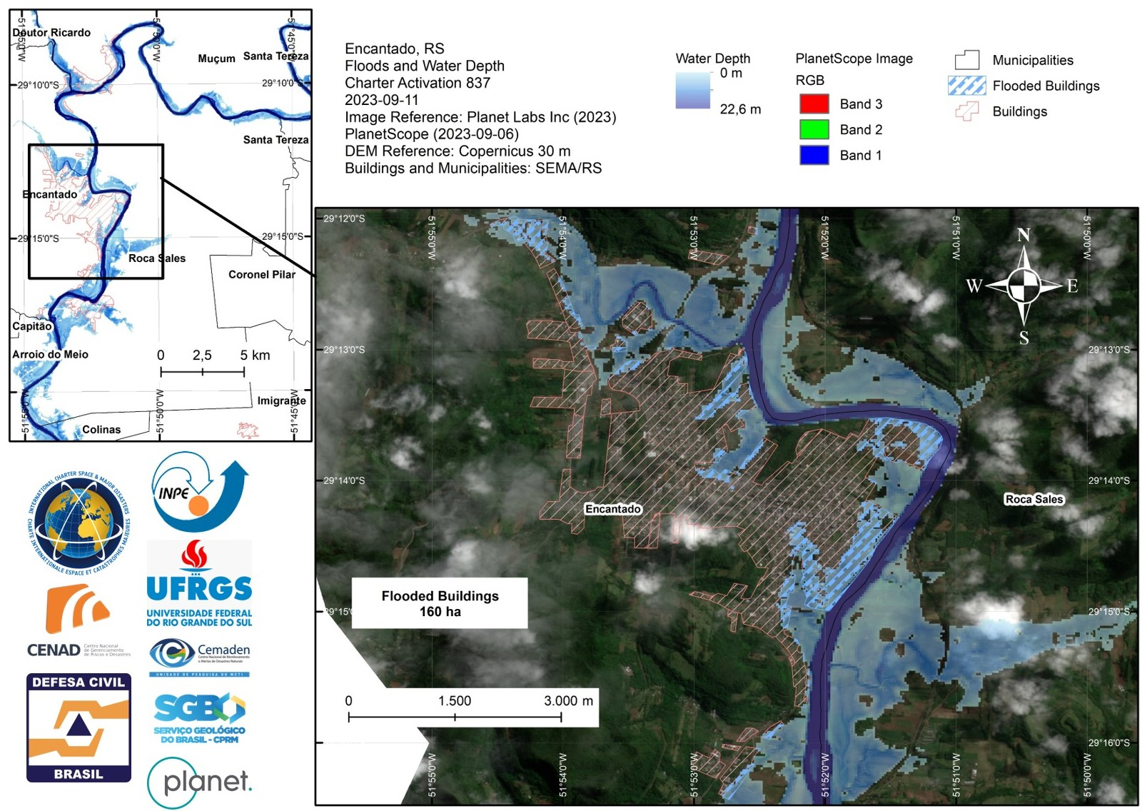
The Depth of Water along the Taquari and Antas rivers in Encantado, State of Rio Grande do Sul, Brazil
Copyright: © Planet Labs Inc. (2023)
Map produced by INPE (Instituto Nacional de Pesquisas Espaciais).
Information about the Product
Acquired: 06/09/2023
Source: PlanetScope
Category: Delineation Monitoring Maps
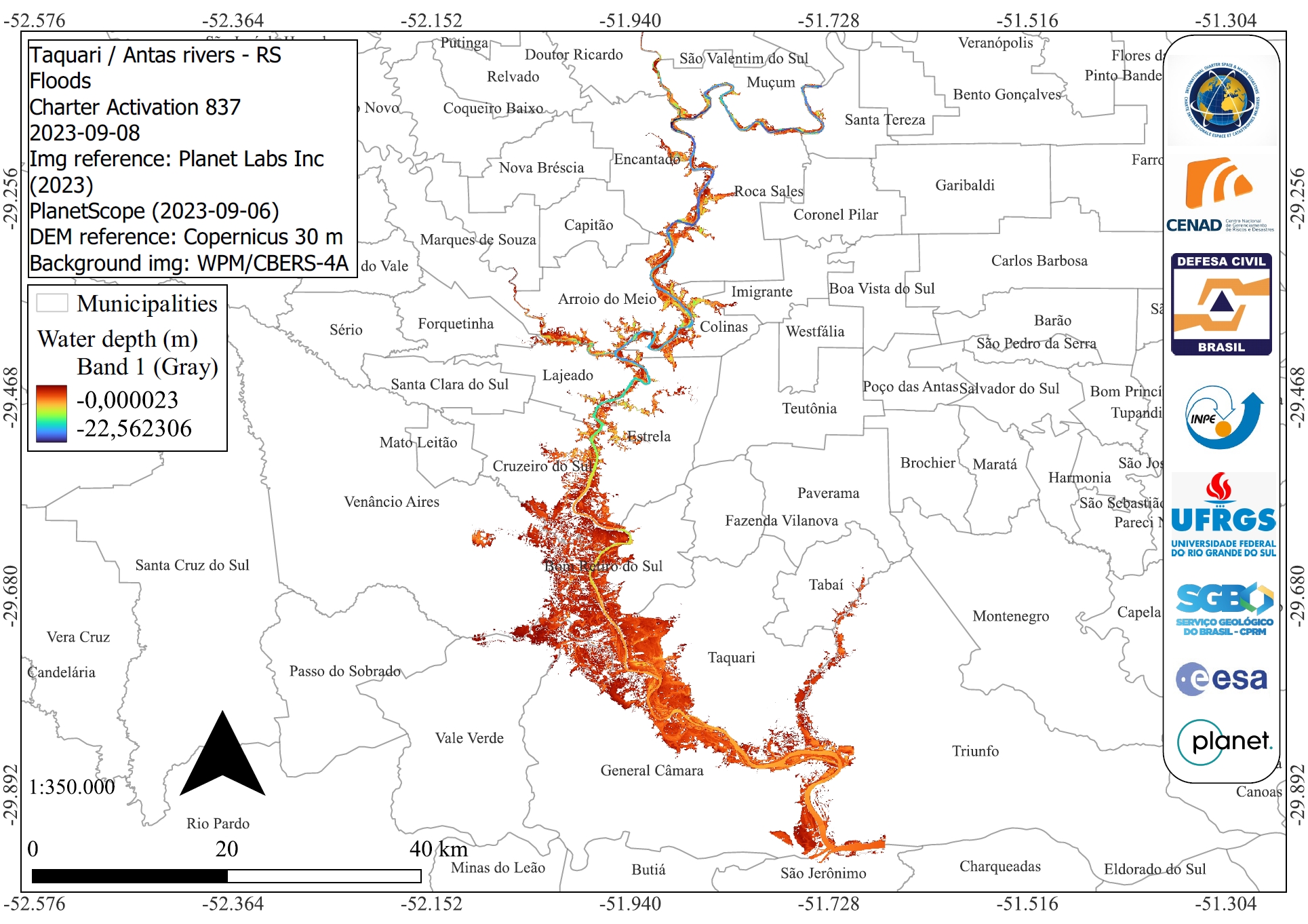
Areas affected by flooding of the Taquari and Antas rivers from Muçum to Triunfo, State of Rio Grande do Sul, Brazil
Copyright: © Planet Labs Inc. (2023)
Map produced by INPE (Instituto Nacional de Pesquisas Espaciais).
Information about the Product
Acquired: 06/09/2023
Source: PlanetScope
Category: Delineation Monitoring Maps
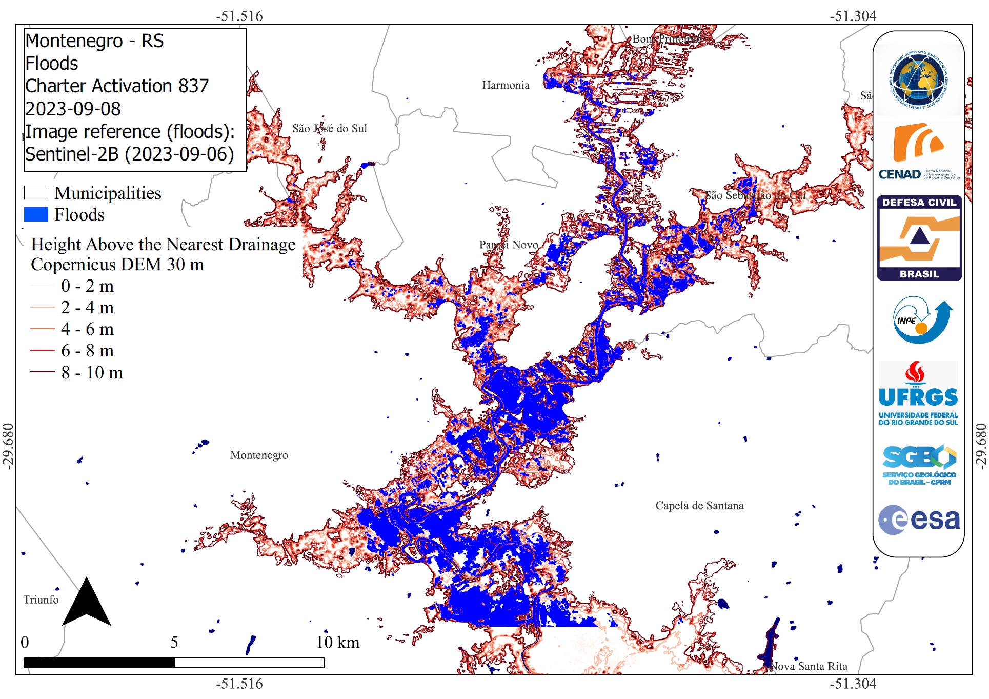
Flooding, shown as Height Above the Nearest Drainage, around Montenegro, State of Rio Grande do Sul, Brazil
Copyright: Contains modified Copernicus Sentinel data (2023)
Map produced by INPE (Instituto Nacional de Pesquisas Espaciais).
Information about the Product
Acquired: 06/09/2023
Source: Sentinel-2
Category: Delineation Monitoring Maps
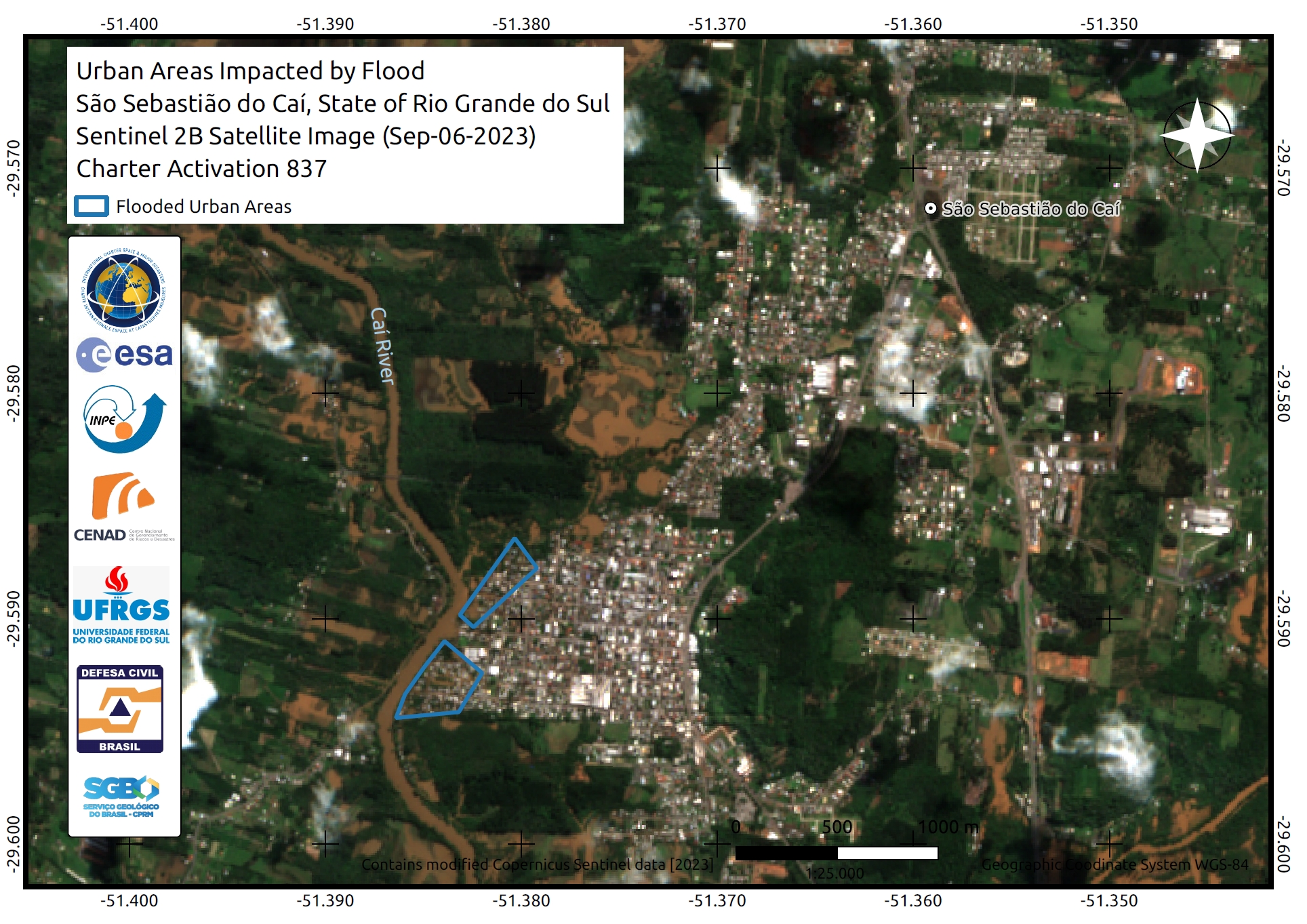
Urban Areas Impacted by Flooding in São Sebastião do Caí, State of Rio Grande do Sul, Brazil
Copyright: Contains modified Copernicus Sentinel data (2023)
Map produced by INPE (Instituto Nacional de Pesquisas Espaciais).
Information about the Product
Acquired: 06/09/2023
Source: Sentinel-2
Category: Delineation Map
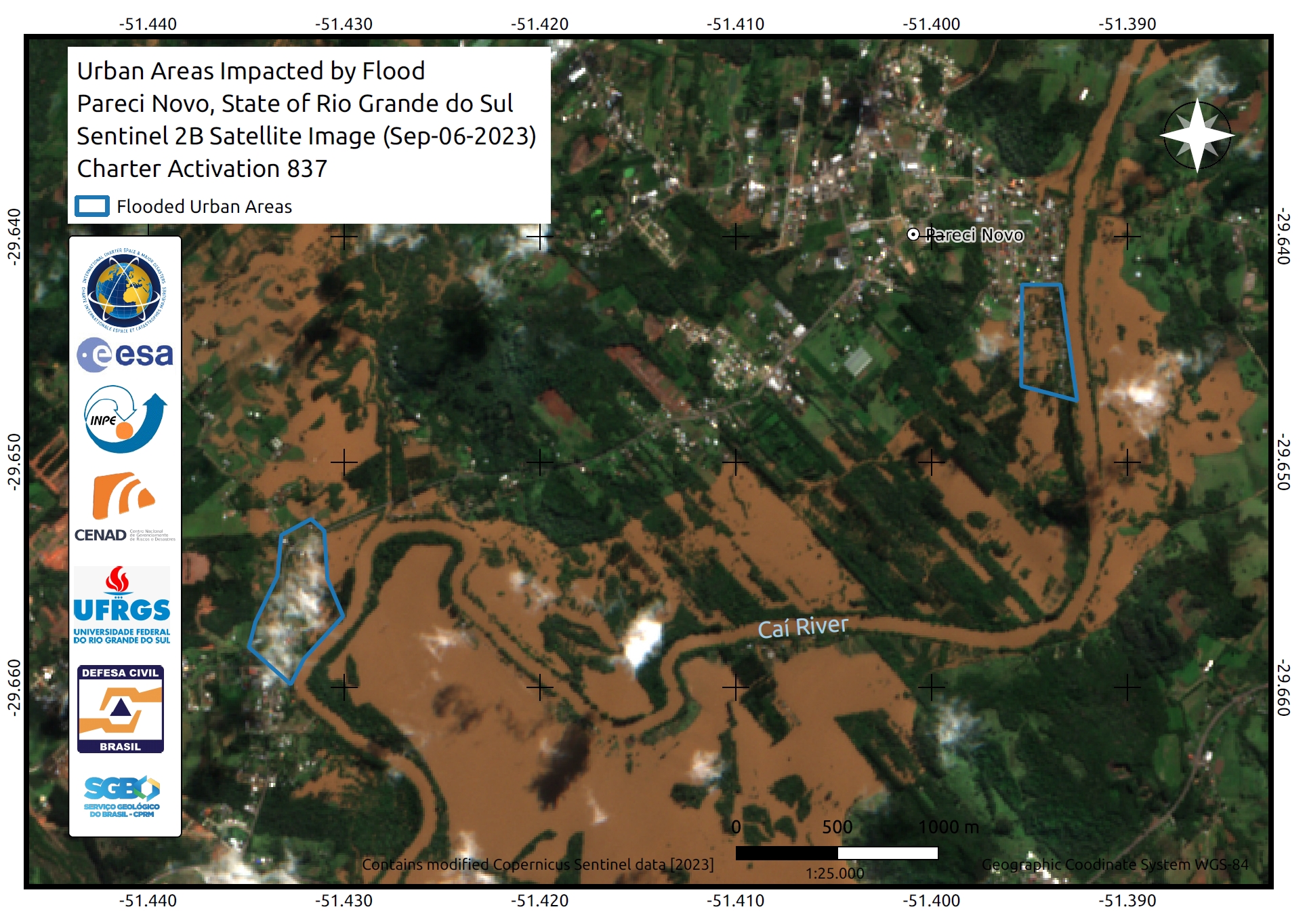
Urban Areas Impacted by Flooding in Pareci Novo, State of Rio Grande do Sul, Brazil
Copyright: Contains modified Copernicus Sentinel data (2023).
Map produced by INPE (Instituto Nacional de Pesquisas Espaciais).
Information about the Product
Acquired: 06/09/2023
Source: Sentinel-2
Category: Delineation Map
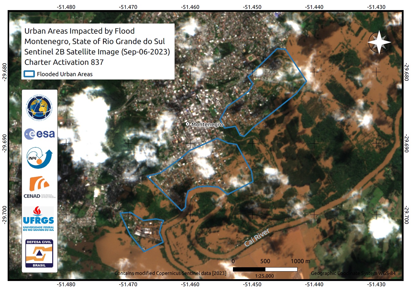
Urban Areas Impacted by Flood in Montenegro, State of Rio Grande do Sul, Brazil
Copyright: Contains modified Copernicus Sentinel data (2023)
Map produced by INPE (Instituto Nacional de Pesquisas Espaciais)
Information about the Product
Acquired: 06/09/2023
Source: Sentinel-2
Category: Delineation Map
 Back to the full activation archive

