 English
 Spanish
 French
 Chinese
 Russian
 Portuguese
 Latest Activation
Charter activations
Flooding in Brazil
Approximately two months after being hit by an extratropical cyclone, Vale do Taquari in Rio Grande do Sul, was once again affected by storms and floods.
On Saturday 18 November 2023, the Taquari River burst its banks, causing flooding in the streets of cities in the region.
People residing in risk areas were requested to take preventive measures in advance and contact the Civil Defense of their municipality in case of emergency.
In September, an extratropical cyclone passed through Rio Grande do Sul and left 50 people dead in the state. Vale do Taquari was the most affected region, with 16 deaths in the city of Muçum and 13 deaths in Roca Sales alone.
| Type of Event: | Flood |
| Location of Event: | Brazil |
| Date of Charter Activation: | 2023-11-18 |
| Time of Charter Activation: | 20:26 |
| Time zone of Charter Activation: | UTC-03:00 |
| Charter Requestor: | CENAD on behalf of Geological Survey of Brazil |
| Activation ID: | 851 |
| Project Management: | Artur Matos (SGB - Serviço Geológico Brasileiro) |
| Value Adding: | Manoel Araújo Sousa Júnior (Federal University of Santa Maria) Alisson Oliveira (INPE) Silvia Pardi LaCruz (Federal University of Santa Maria) Alessandro Silva (SGB) AEP - Agencia Espacial del Paraguay Thiago Bazzan (INPE) Brenda Rocha (INPE) |
Products
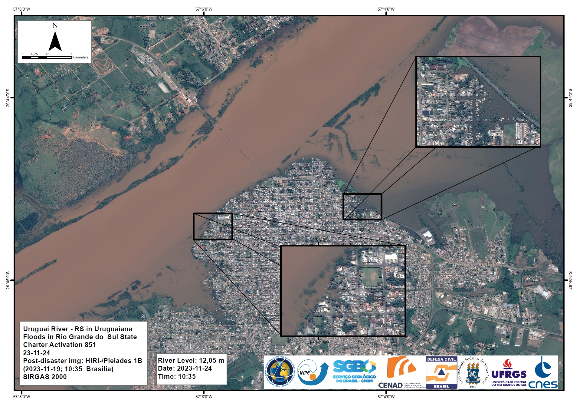
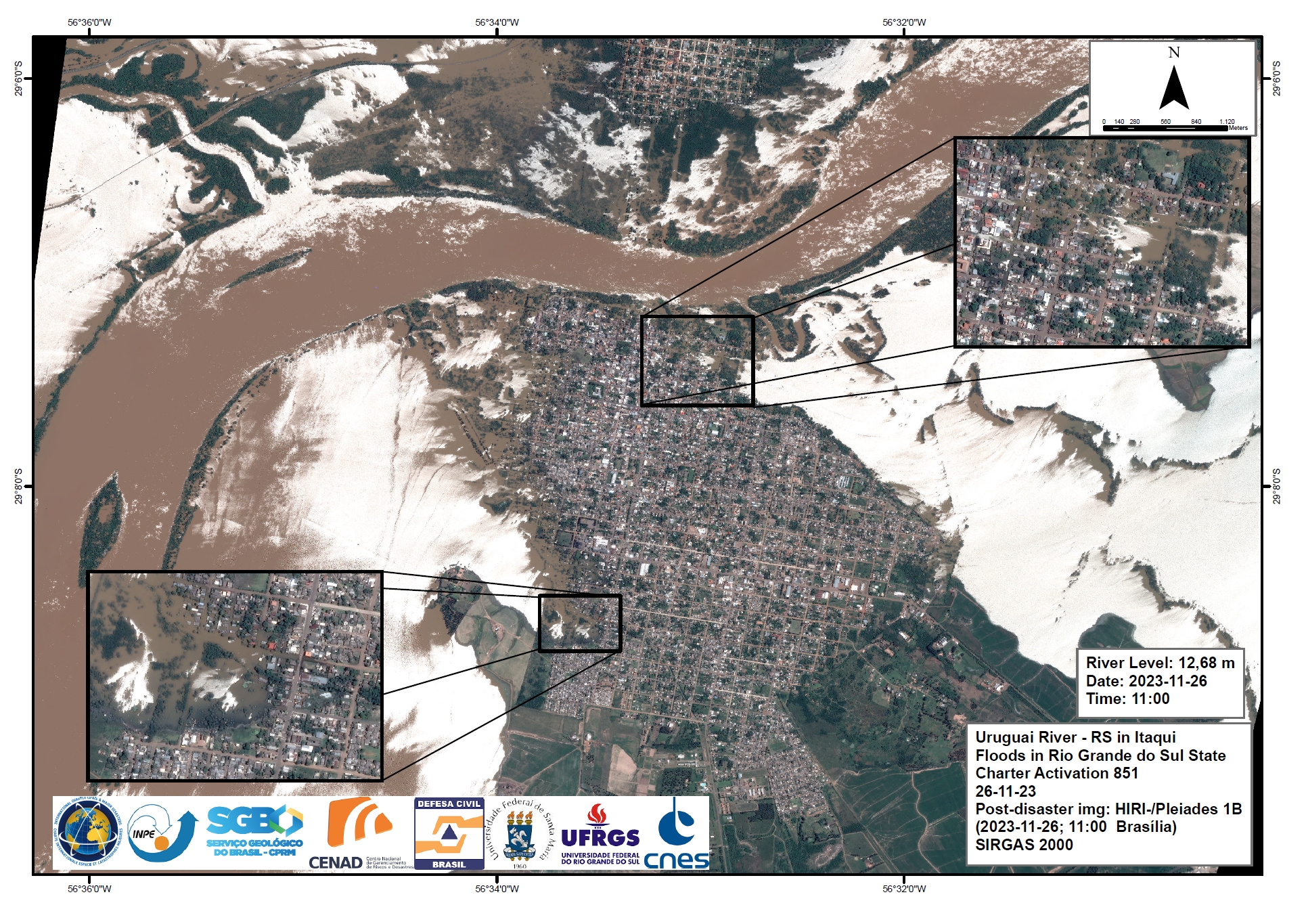
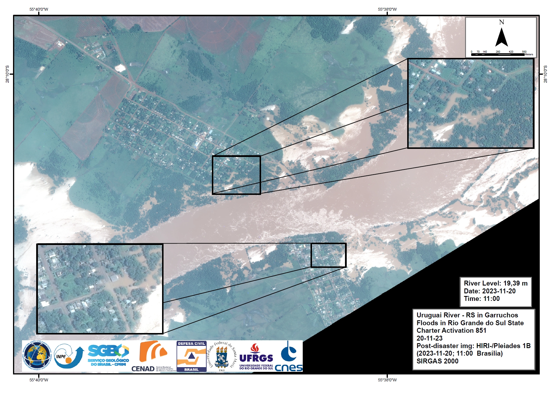
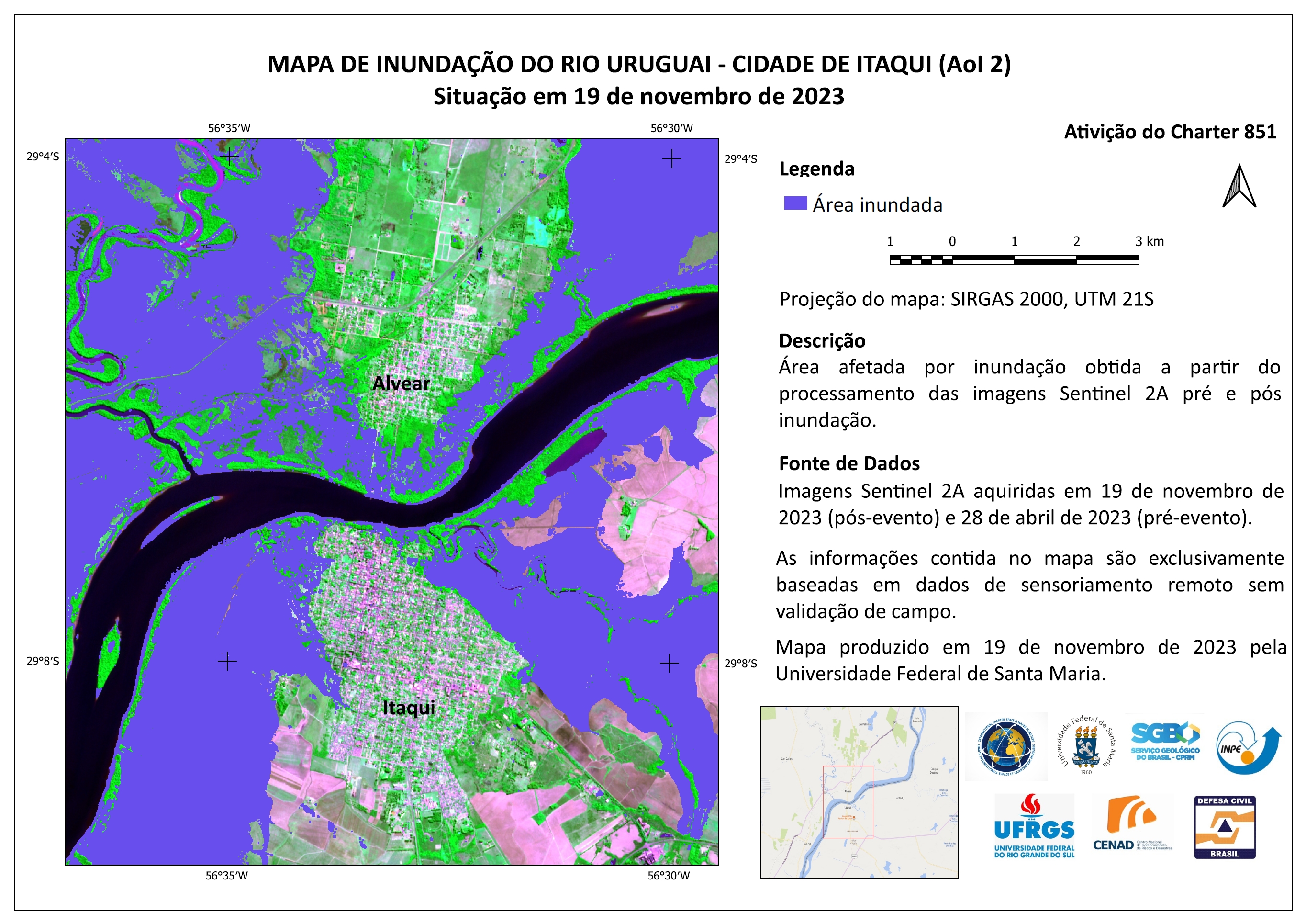
Areas affected by Flooding along the Uruguai River, Uruguaiana, Rio Grande do Sul State, Brazil
Copyright: WorldView-2 © (2023) DigitalGlobe, Inc., Longmont CO USA 80503.
DigitalGlobe and the DigitalGlobe logos are trademarks of DigitalGlobe, Inc. The use and/or dissemination of this data and/or of any product in any way derived there from are restricted. Unauthorized use and/or dissemination is prohibited.
Map produced by Geological Survey of Brazil - SGB
Information about the Product
Acquired: 25/11/2023
Source: WorldView-2
Category: Reference Map
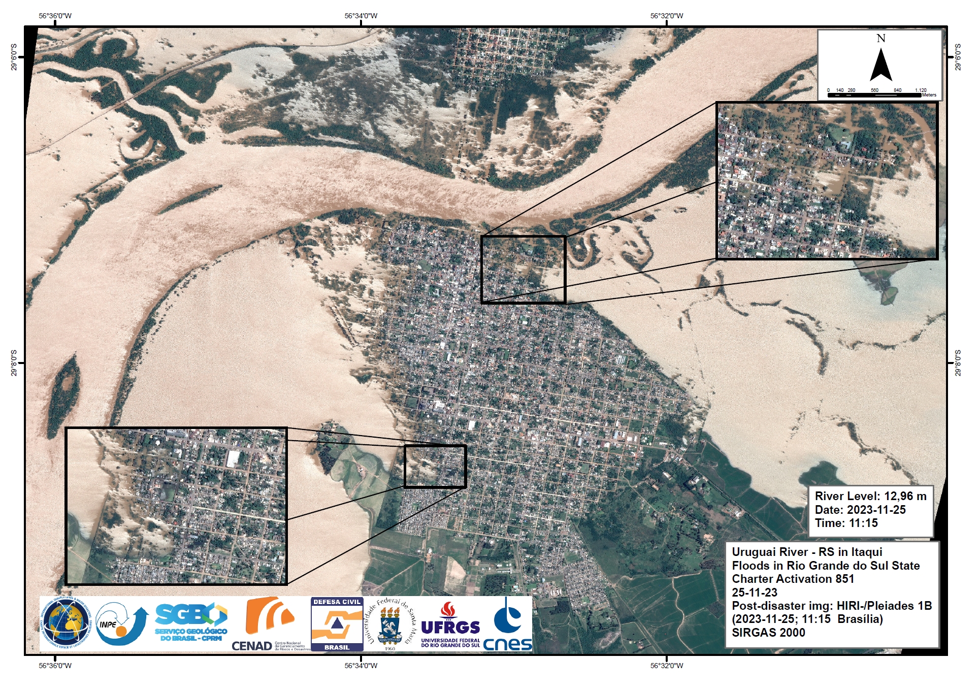
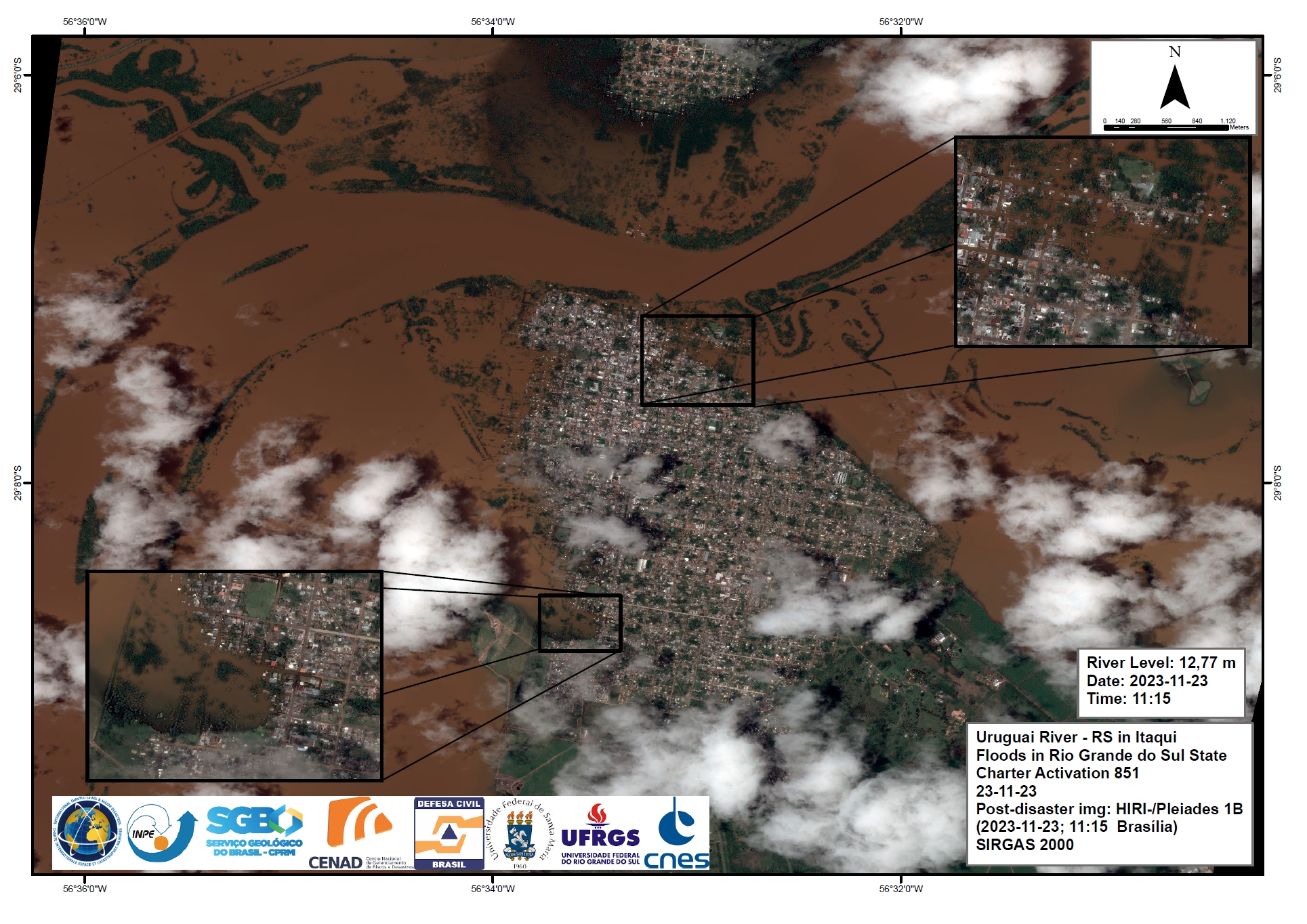
Areas affected by Flooding along the Uruguai River, Uruguaiana, Rio Grande do Sul State, Brazil
Copyright: WorldView-2 © (2023) DigitalGlobe, Inc., Longmont CO USA 80503.~
DigitalGlobe and the DigitalGlobe logos are trademarks of DigitalGlobe, Inc. The use and/or dissemination of this data and/or of any product in any way derived there from are restricted. Unauthorized use and/or dissemination is prohibited.
Map produced by Geological Survey of Brazil - SGB
Information about the Product
Acquired: 06/11/2023
Source: WorldView-2
Category: Reference Map
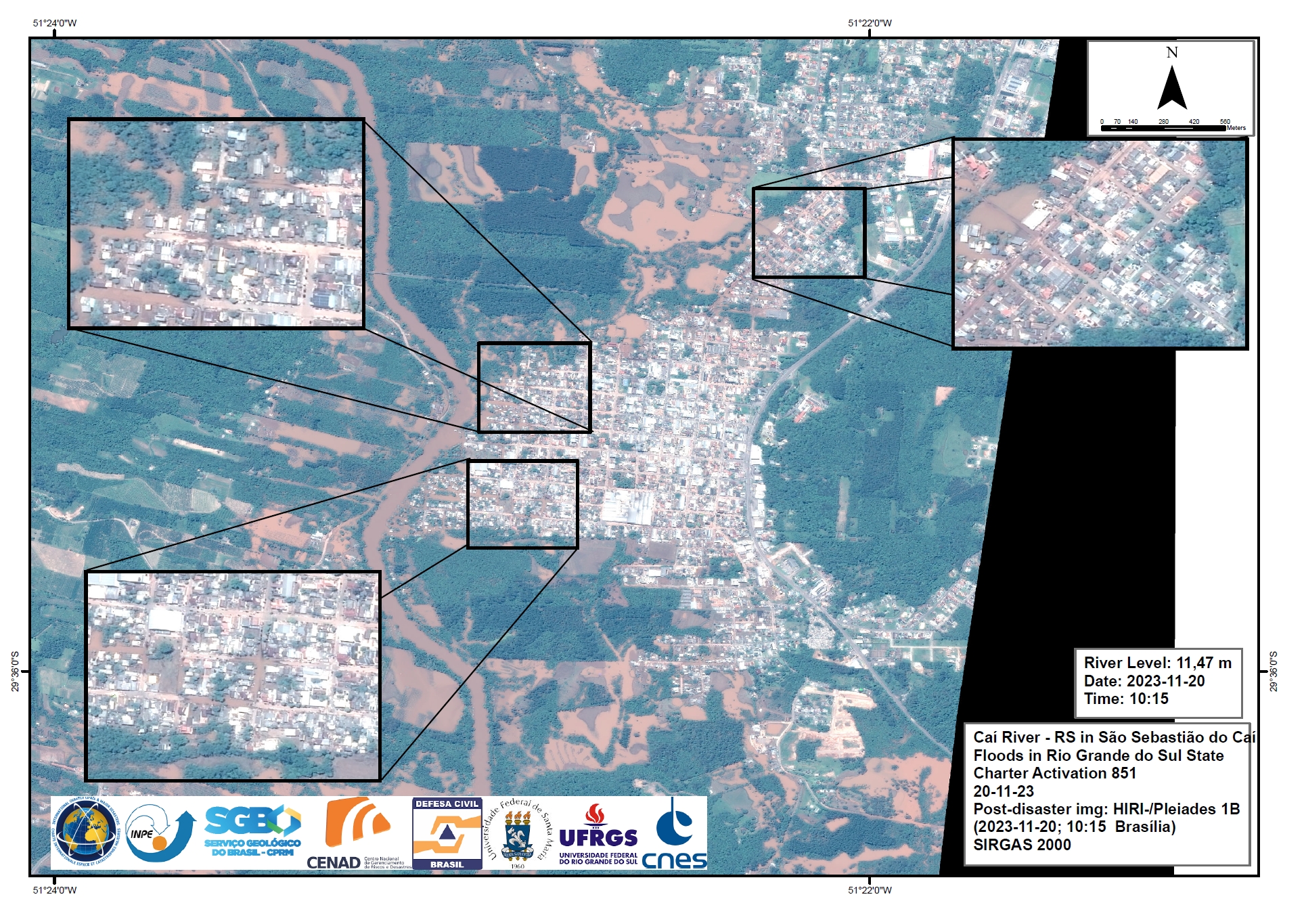
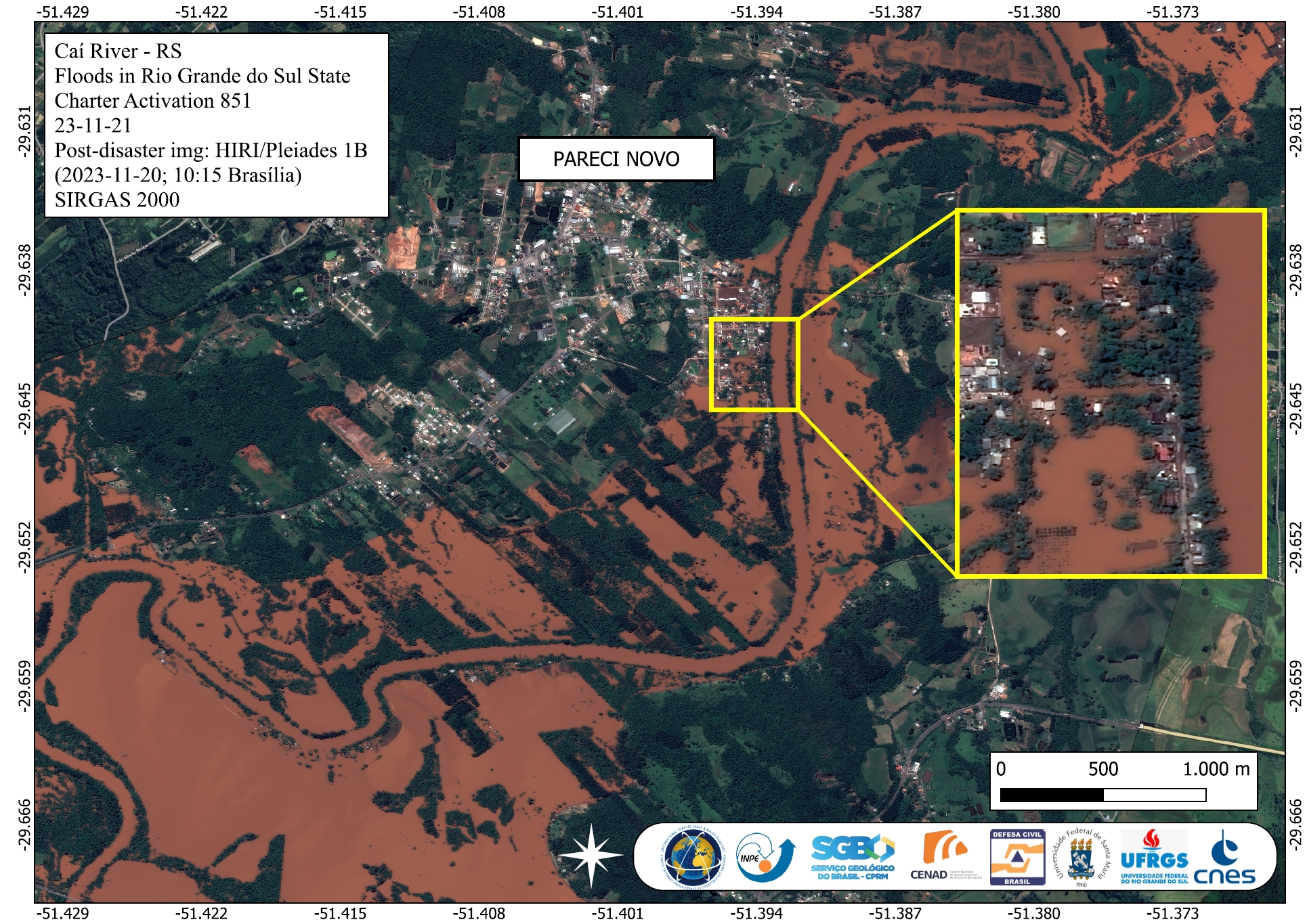
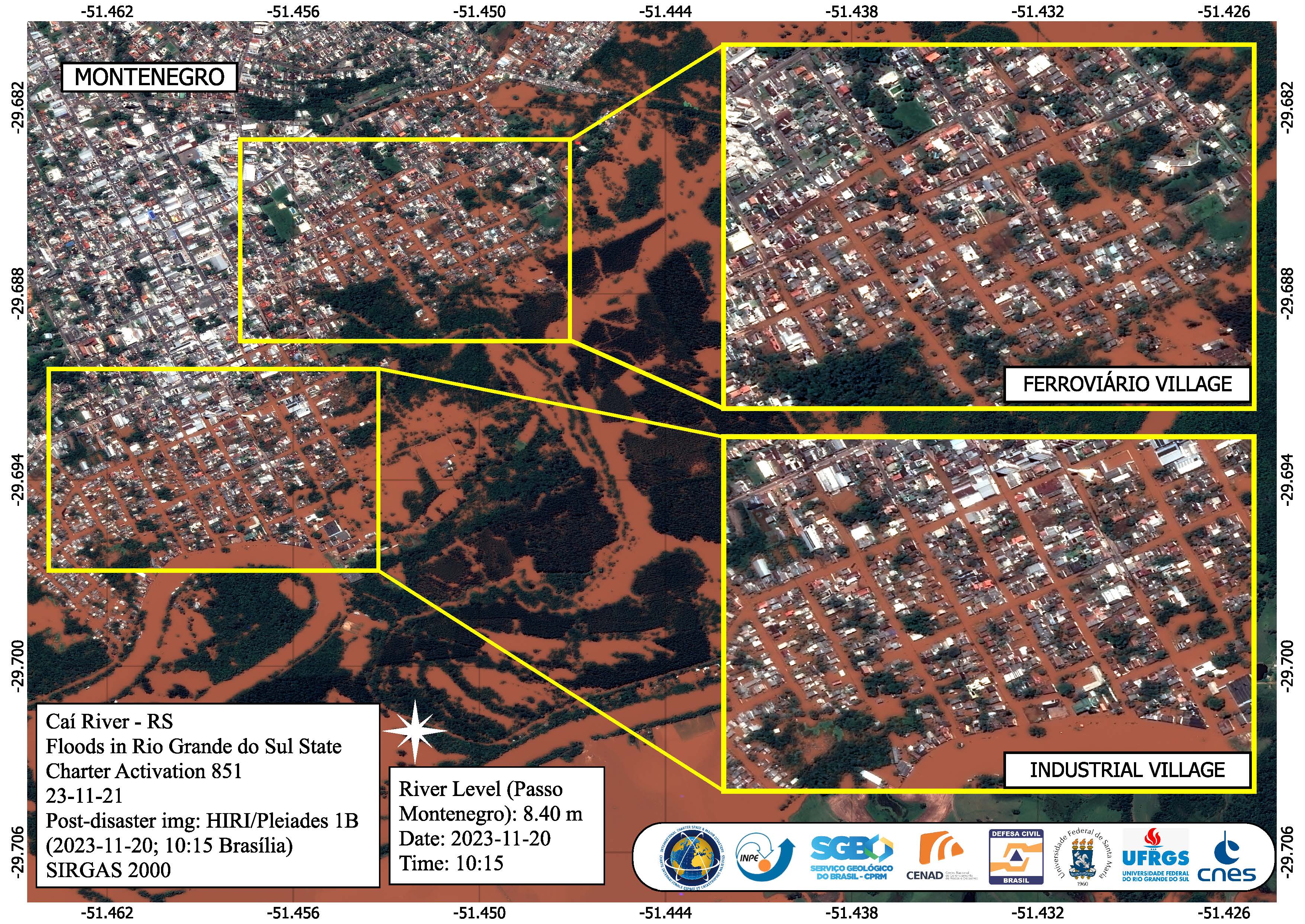
Areas affected by Flooding in São Sebastião do Caí, Rio Grande Do Sul State, Brazil
Copyright: Includes Pleiades material © CNES (2023), Distribution Airbus DS.
Map produced by Geological Survey of Brazil - SGB
Information about the Product
Acquired: 20/11/2023
Source: Pleiades
Category: Reference Map
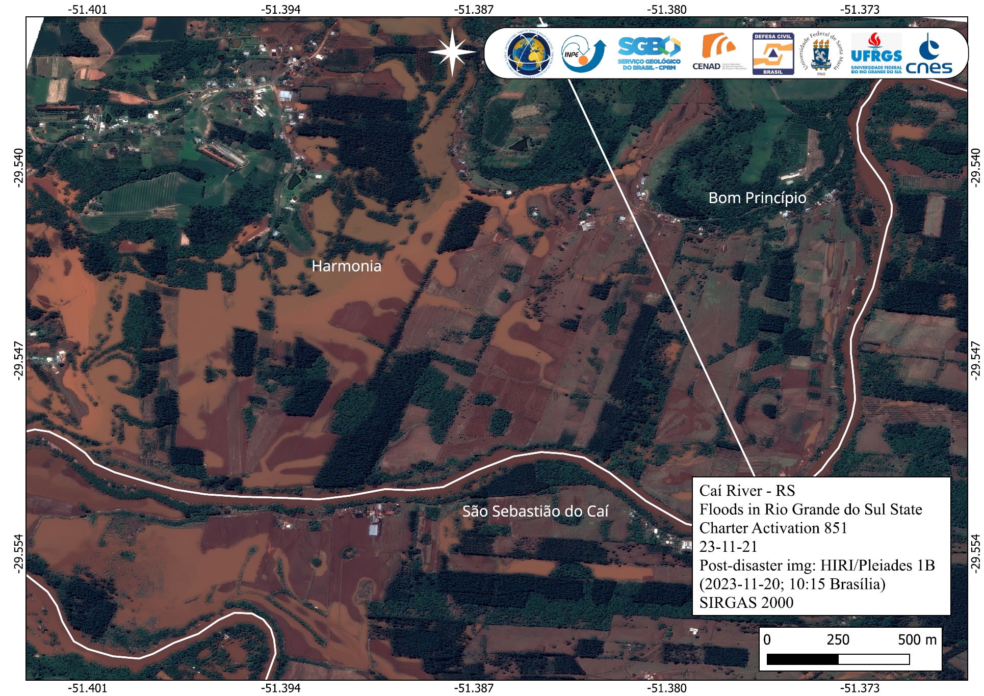
Areas affected by Flooding in Harmonia, Bom Princípio and São Sebastião do Caí, Rio Grande do Sul State, Brazil
Copyright: Includes Pleiades material © CNES (2023), Distribution Airbus DS.
Map produced by INPE
Information about the Product
Acquired: 20/11/2023
Source: Pleiades
Category: Delineation Map
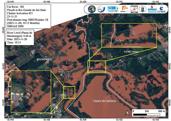
Urban areas affected by floods in Montenegro, Capela de Santana and Pareci Novo, Rio Grande do Sul State, Brazil
Copyright: Includes Pleiades material © CNES (2023), Distribution Airbus DS.
Map produced by INPE
Information about the Product
Acquired: 20/11/2023
Source: Pleiades
Category: Delineation Map
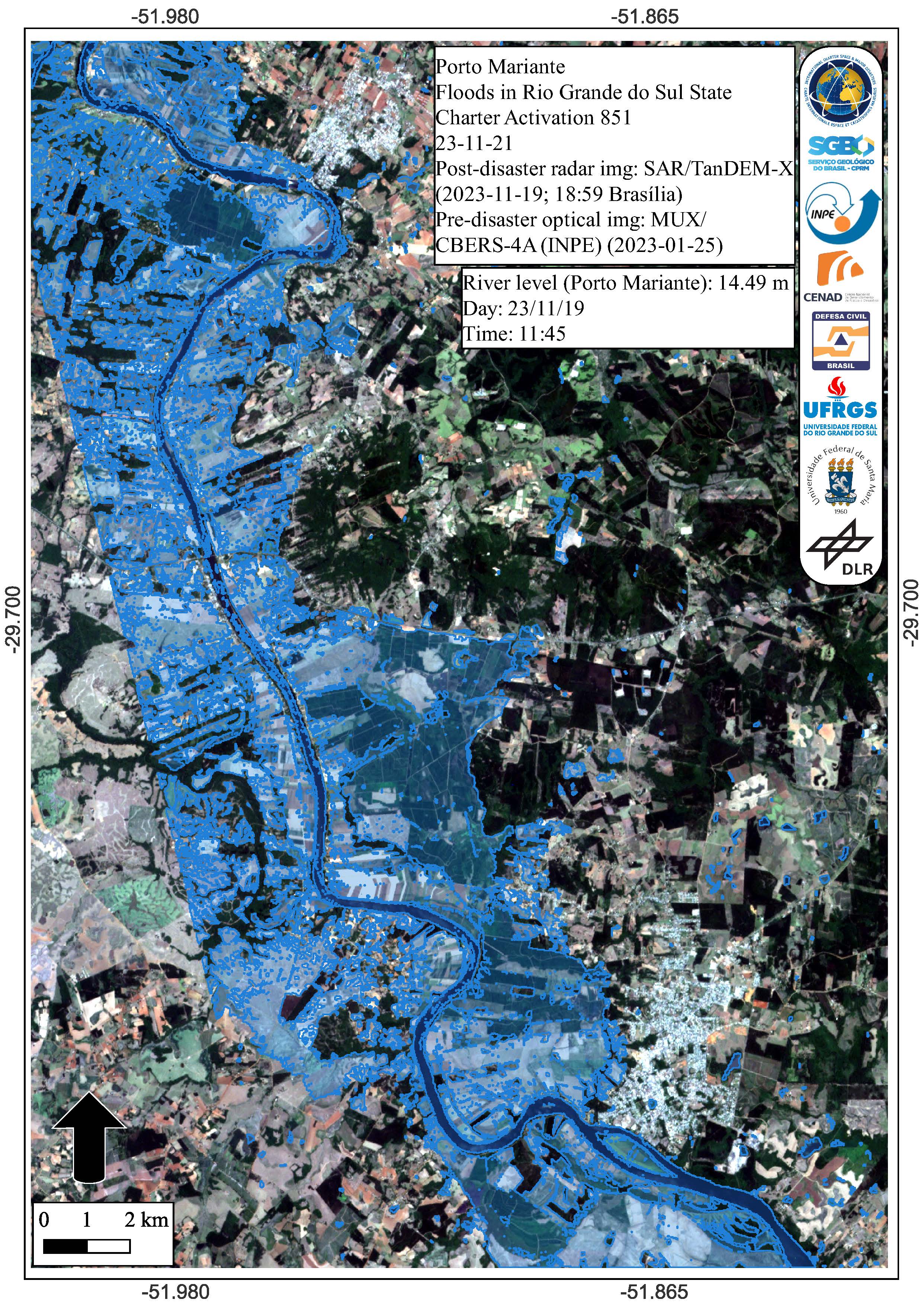
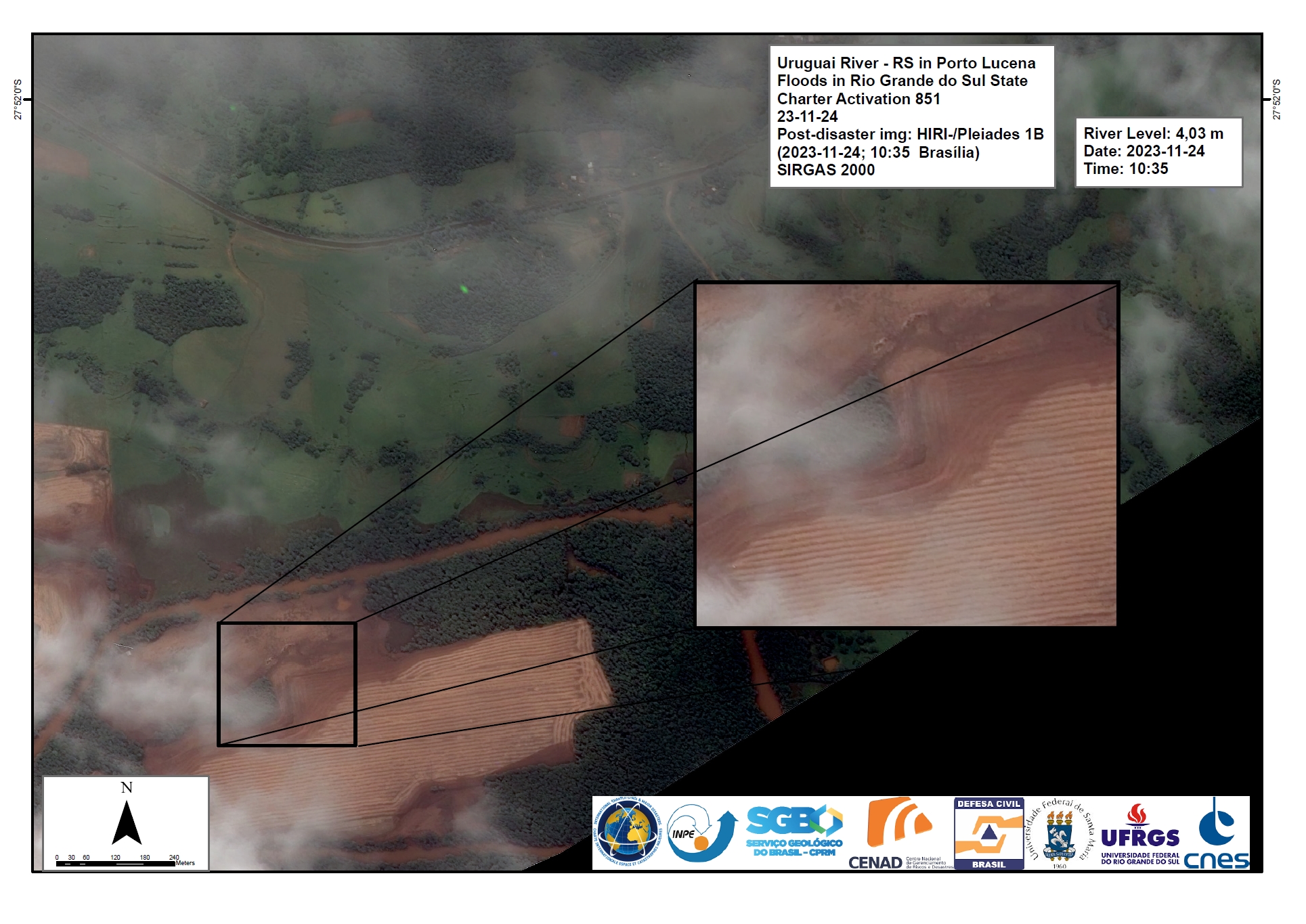
Areas affected by Flooding near Porto Mariante, Rio Grande do Sul State, Brazil
Copyright: CBERS-4 © (2023) INPE
TanDEM-X © DLR e.V. (2023), Distribution Airbus DS Geo GmbH
Map produced by INPE
Information about the Product
Acquired: CBERS-4: 25/01/2023
TanDEM-X: 19/11/2023
Source: CBERS-4 and TanDEM-X
Category: Delineation Map
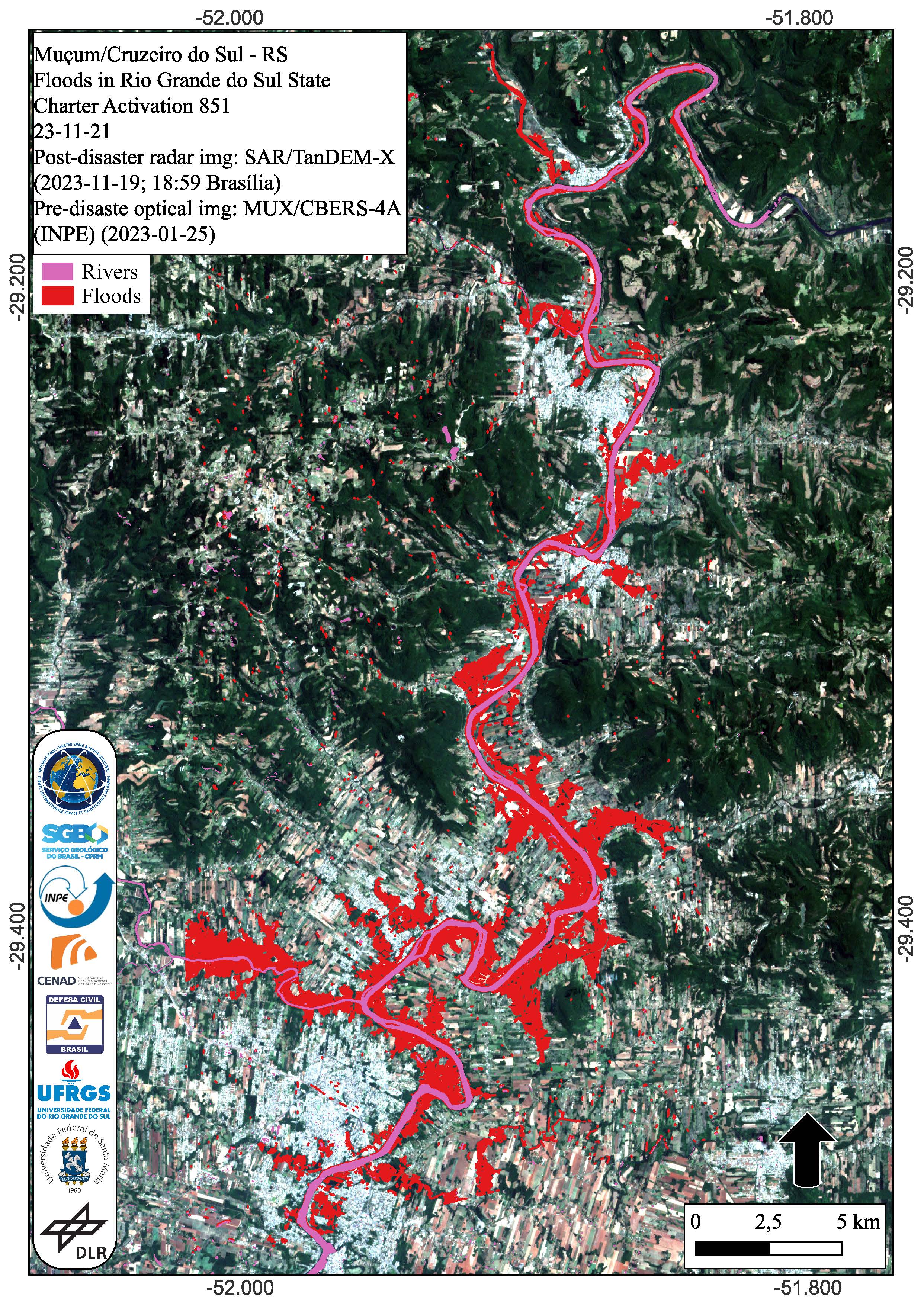
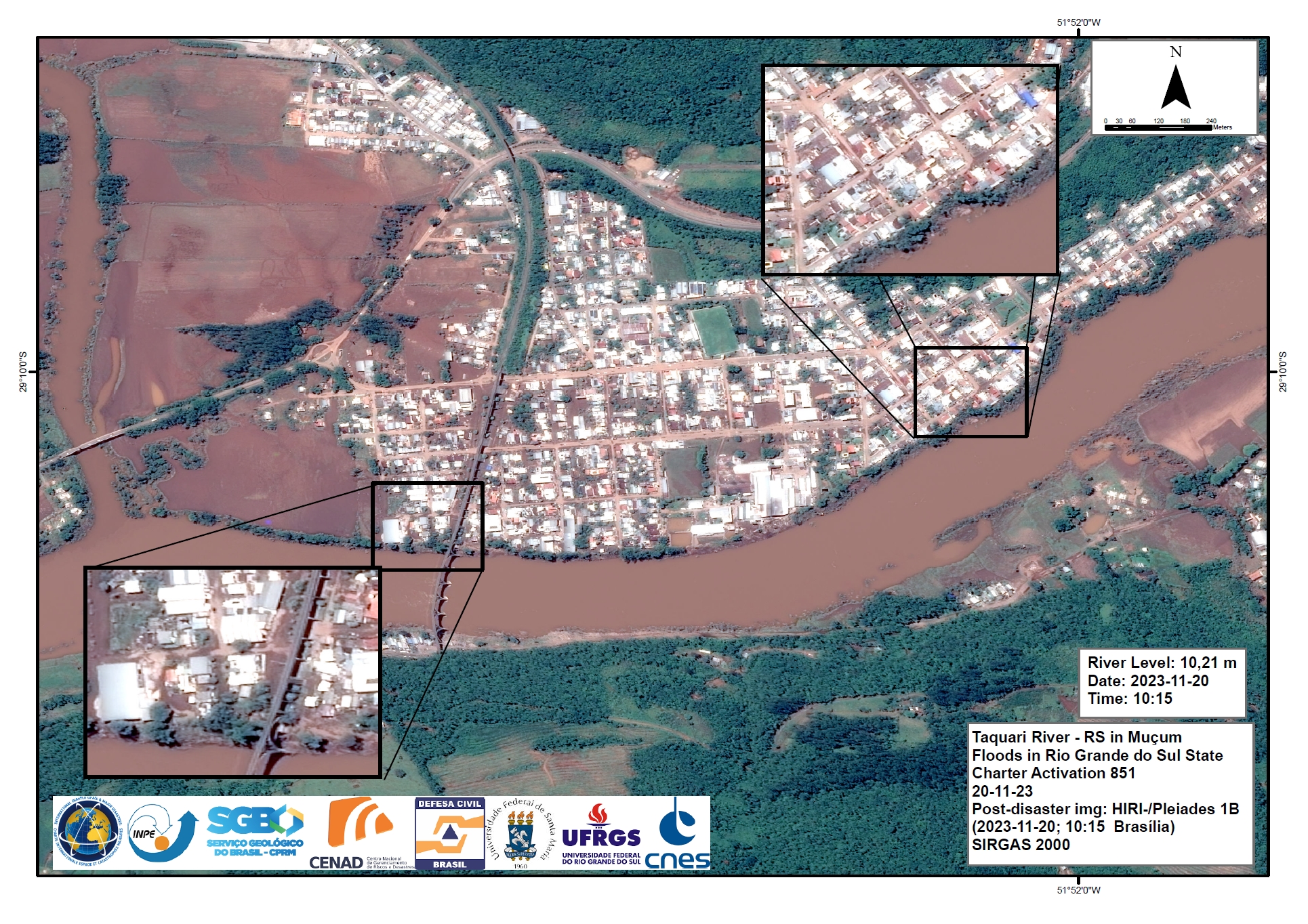
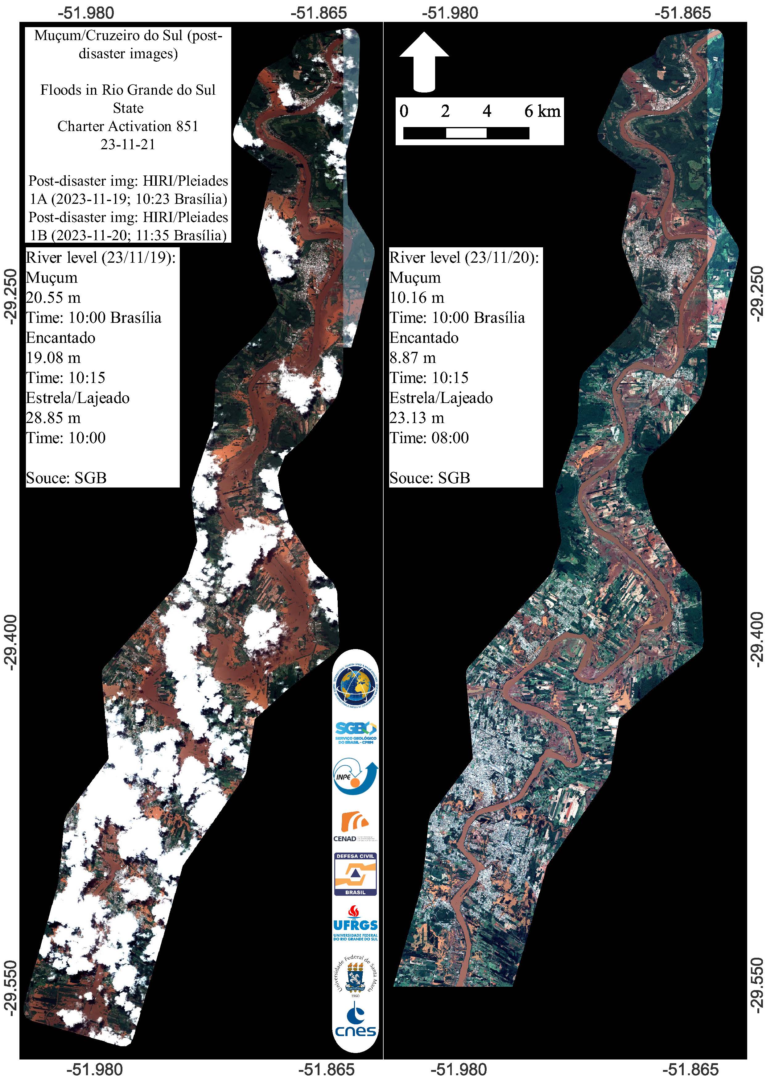
Areas affected by flooding from Muçum to the Cruzeiro do Sul region, Rio Grande do Sul State, Brazil
Copyright: CBERS-4 © (2023) INPE
TanDEM-X © DLR e.V. (2023), Distribution Airbus DS Geo GmbH
Map produced by INPE
Information about the Product
Acquired: CBERS-4: 25/01/2023
TanDEM-X: 19/11/2023
Source: CBERS-4 and TanDEM-X
Category: Delineation Map
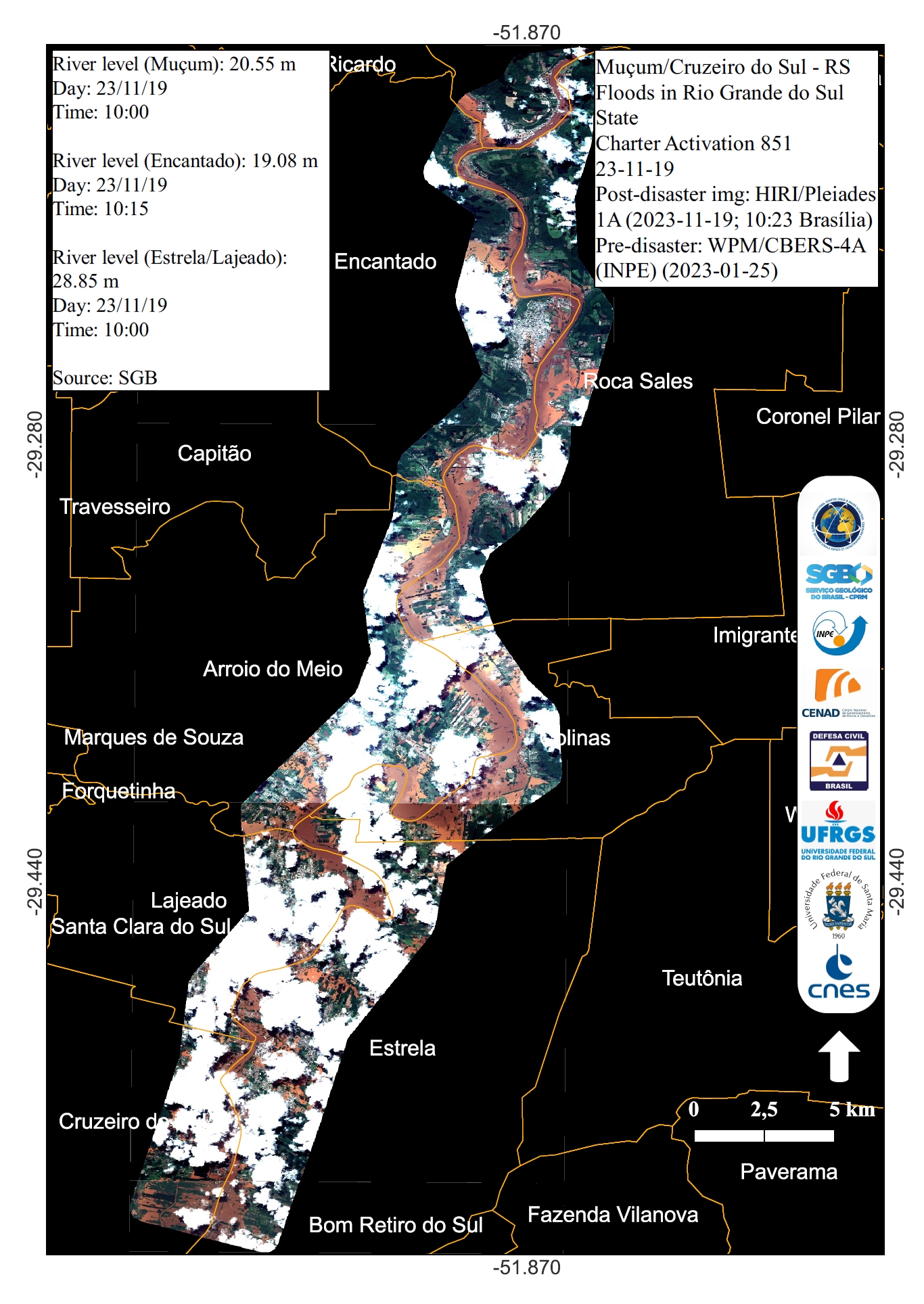
An Overview of Areas Affected by Flooding from Muçum to Cruzeiro do Sul in the Rio Grande do Sul State, Brazil
Copyright: CBERS-4 © (2023) INPE
Includes Pleiades material © CNES (2023), Distribution Airbus DS.
Map produced by INPE
Information about the Product
Acquired: CBERS-4: 25/01/2023
Pleiades: 19/11/2023
Source: CBERS-4 and Pleiades
Category: Reference Map
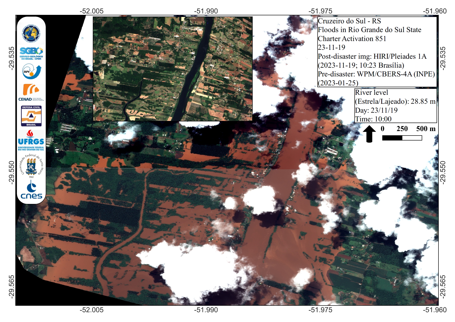
Areas affected by Flooding in Cruzeiro do Sul, Rio Grande Do Sul State, Brazil
Copyright: CBERS-4 © (2023) INPE
Includes Pleiades material © CNES (2023), Distribution Airbus DS.
Map produced by INPE
Information about the Product
Acquired: CBERS-4: 25/01/2023
Pleiades: 19/11/2023
Source: CBERS-4 and Pleiades
Category: Reference Map

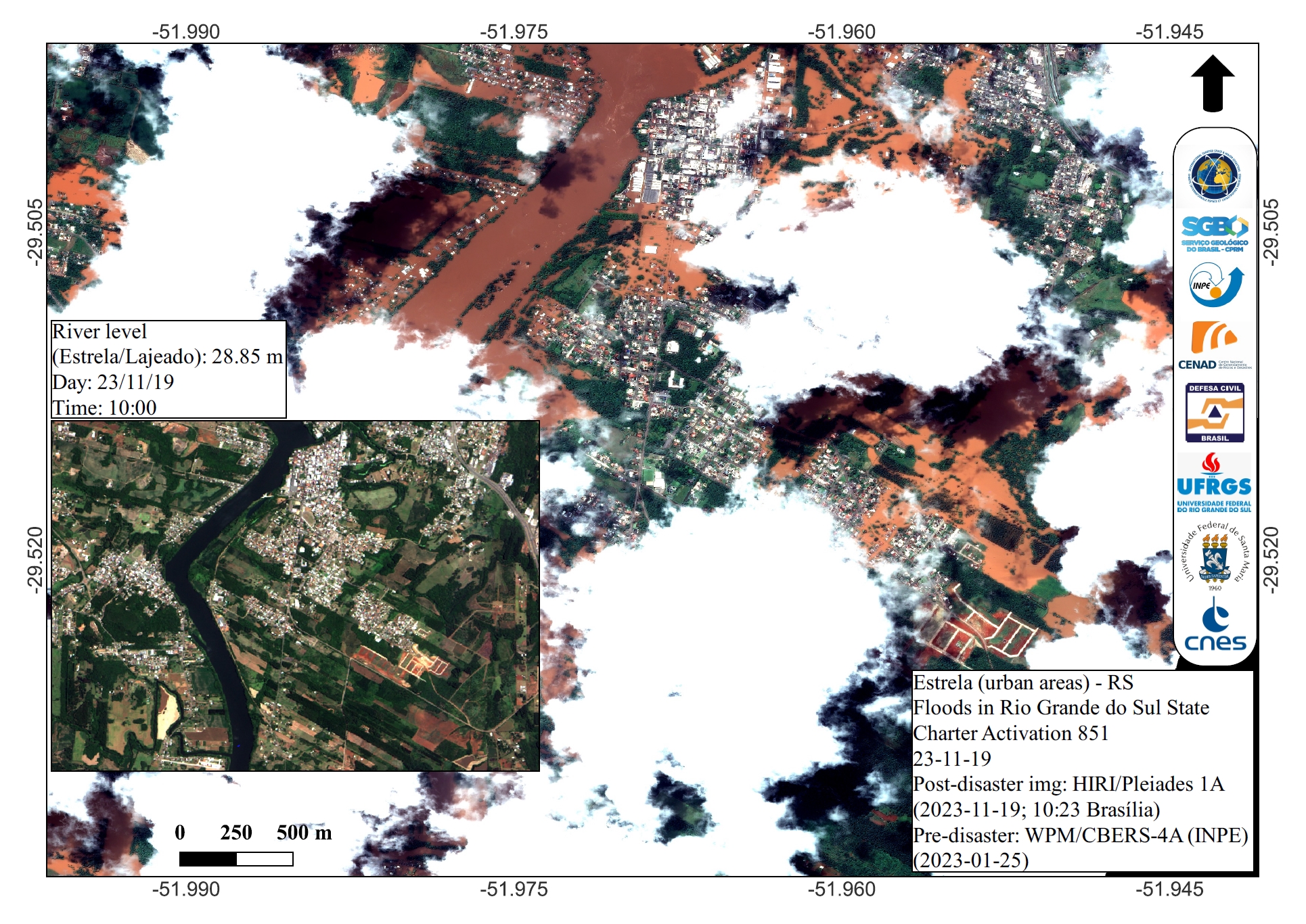
Urban Areas affected by Flooding in Estrela, Rio Grande do Sul State, Brazil
Copyright: CBERS-4 © (2023) INPE
Includes Pleiades material © CNES (2023), Distribution Airbus DS.
Map produced by INPE.
Information about the Product
Acquired: CBERS-4: 25/01/2023
Pleiades: 19/11/2023
Source: CBERS-4 and Pleiades
Category: Reference Map
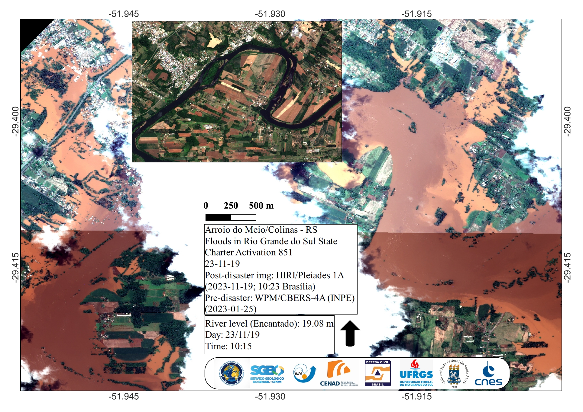
Urban Settlements affected by Flooding in Arroio do Meio and Colinas, Rio Grande Do Sul State, Brazil
Copyright: CBERS-4 © (2023) INPE
Includes Pleiades material © CNES (2023), Distribution Airbus DS.
Map produced by INPE
Information about the Product
Acquired: CBERS-4: 25/01/2023
Pleiades: 19/11/2023
Source: CBERS-4 and Pleiades
Category: Reference Map
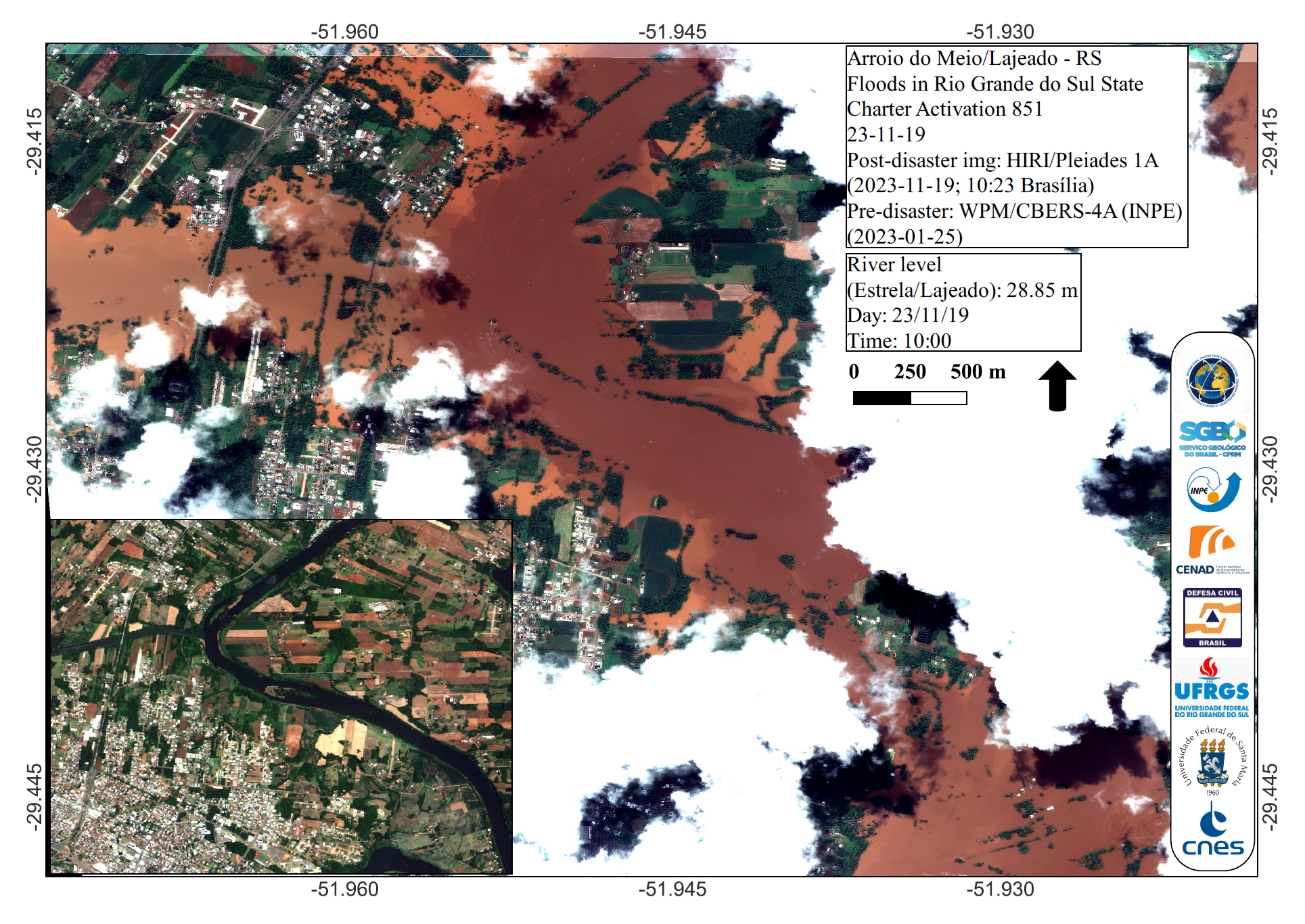
Urban Areas affected by Flooding in Arroio do Meio and Lajeado, Rio Grande Do Sul State, Brazil
Copyright: CBERS-4 © (2023) INPE
Includes Pleiades material © CNES (2023), Distribution Airbus DS.
Map produced by INPE.
Information about the Product
Acquired: CBERS-4: 25/01/2023
Pleiades: 19/11/2023
Source: CBERS-4 and Pleiades
Category: Reference Map
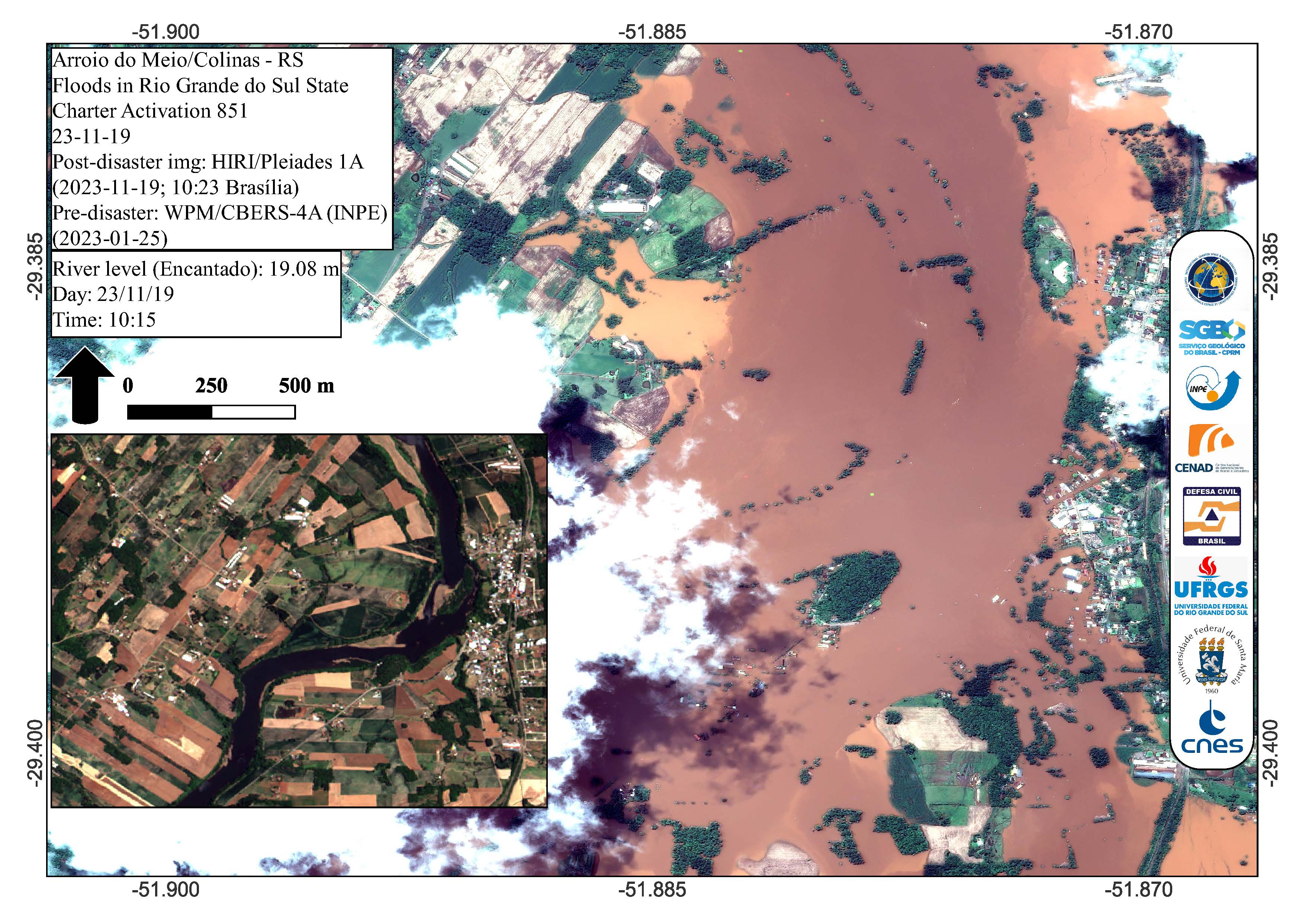
Urban Areas affected by Flooding in Arroio do Meio and Colinas, Rio Grande Do Sul State, Brazil
Copyright: CBERS-4 © (2023) INPE
Includes Pleiades material © CNES (2023), Distribution Airbus DS.
Map produced by INPE
Information about the Product
Acquired: CBERS-4: 25/01/2023
Pleiades: 19/11/2023
Source: CBERS-4 and Pleiades
Category: Reference Map
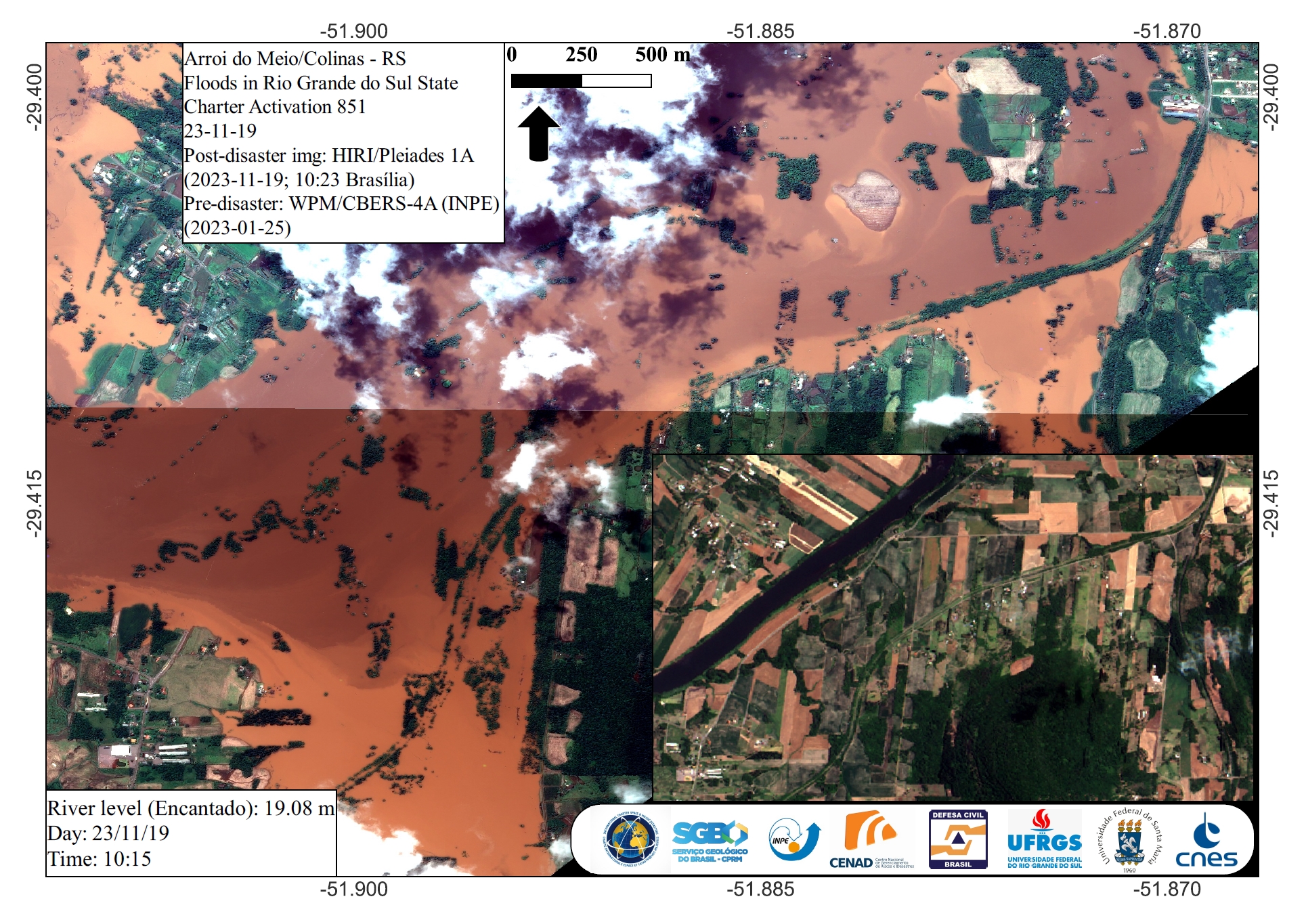
Areas affected by Flooding near Arroio do Meio and Colinas, Rio Grande Do Sul State, Brazil
Copyright: CBERS-4 © (2023) INPE
Includes Pleiades material © CNES (2023), Distribution Airbus DS.
Map produced by INPE.
Information about the Product
Acquired: CBERS-4: 25/01/2023
Pleiades: 19/11/2023
Source: CBERS-4 and Pleiades
Category: Reference Map

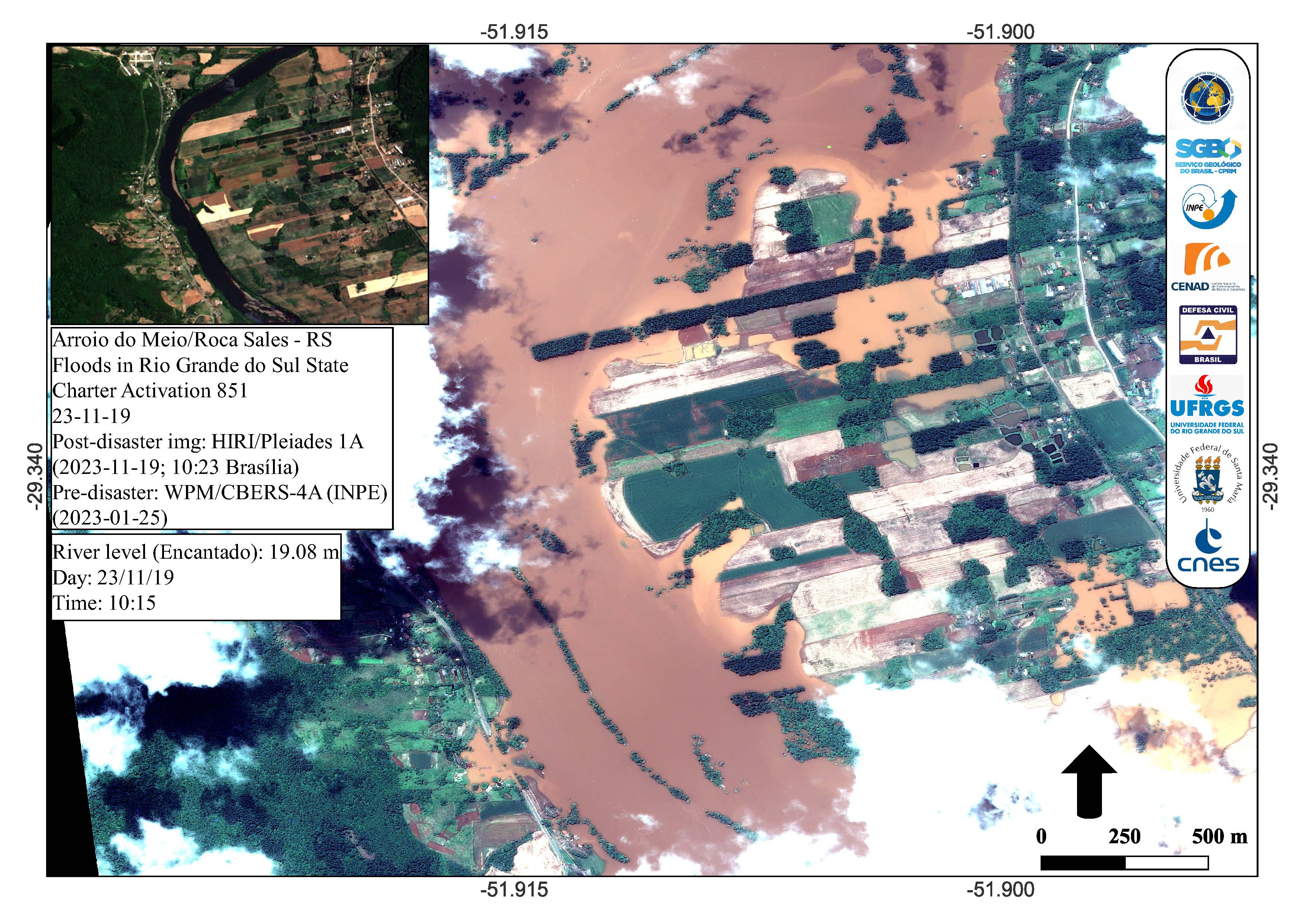
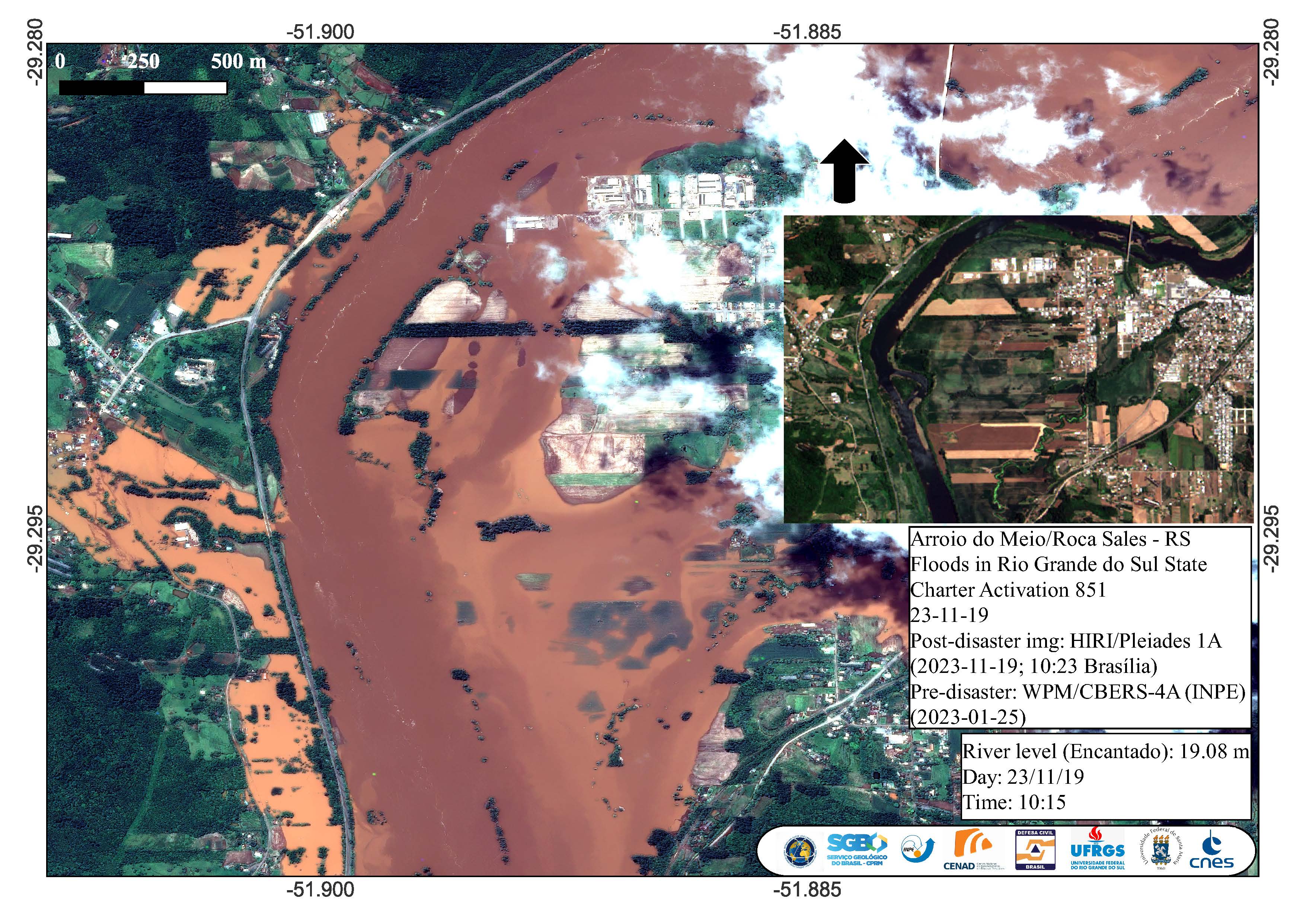
Agricultural areas affected by floods near Arroio do Meio and Roca Sales, Rio Grande do Sul State, Brazil
Copyright: CBERS-4 © (2023) INPE
Includes Pleiades material © CNES (2023), Distribution Airbus DS.
Map produced by INPE
Information about the Product
Acquired: CBERS-4: 25/01/2023
Pleiades: 19/11/2023
Source: CBERS-4 and Pleiades
Category: Reference Map
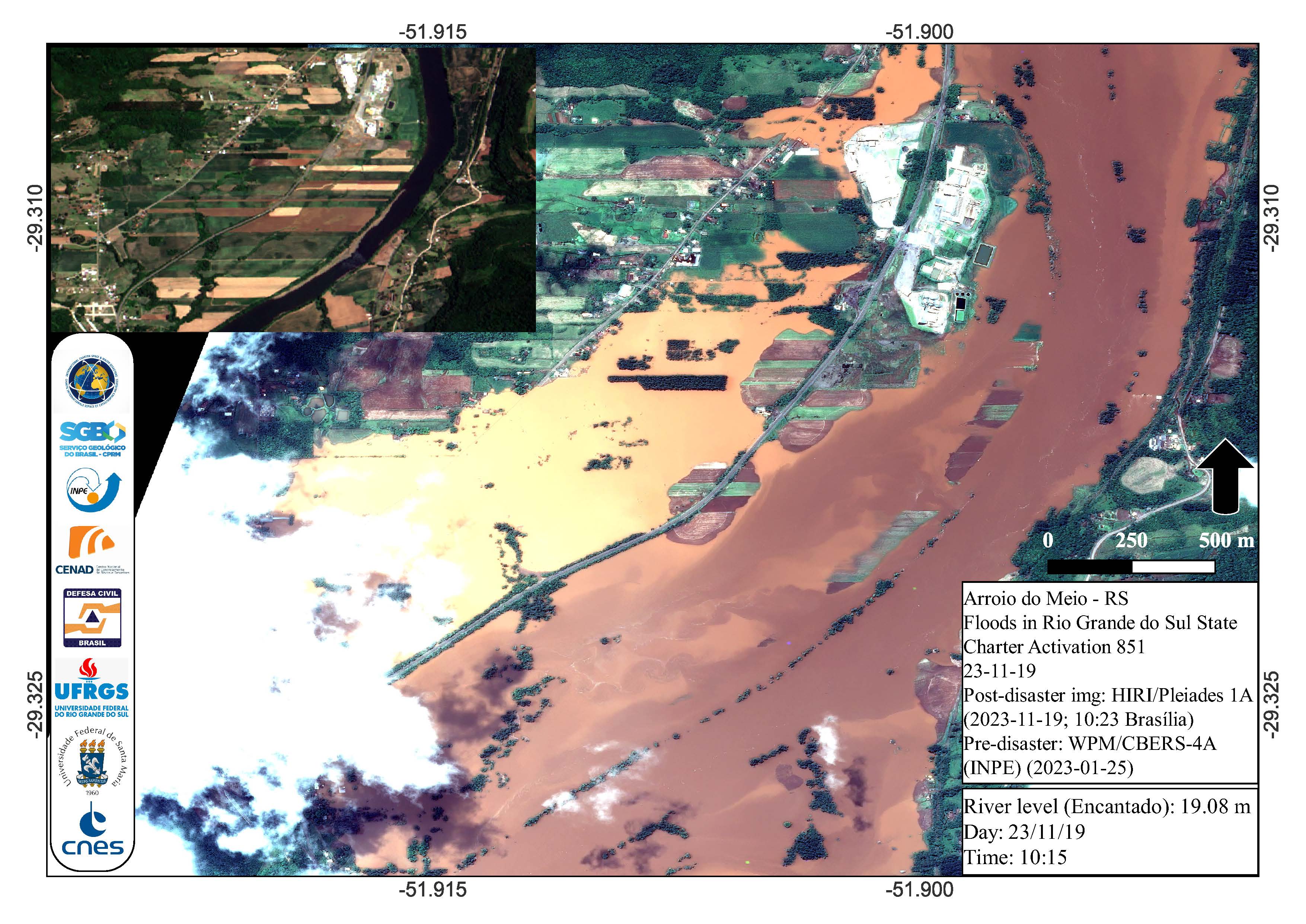
Areas affected by floods in Arroio do Meio, Rio Grande do Sul State, Brazil
Copyright: CBERS-4 © (2023) INPE
Includes Pleiades material © CNES (2023), Distribution Airbus DS.
Map produced by INPE
Information about the Product
Acquired: CBERS-4: 25/01/2023
Pleiades: 19/11/2023
Source: CBERS-4 and Pleiades
Category: Reference Map
Areas affected by floods near Arroio do Meio and Roca Sales, Rio Grande do Sul State, Brazil
Copyright: CBERS-4 © (2023) INPE
Includes Pleiades material © CNES (2023), Distribution Airbus DS.
Map produced by INPE
Information about the Product
Acquired: CBERS-4: 25/01/2023
Pleiades: 19/11/2023
Source: CBERS-4 and Pleiades
Category: Reference Map
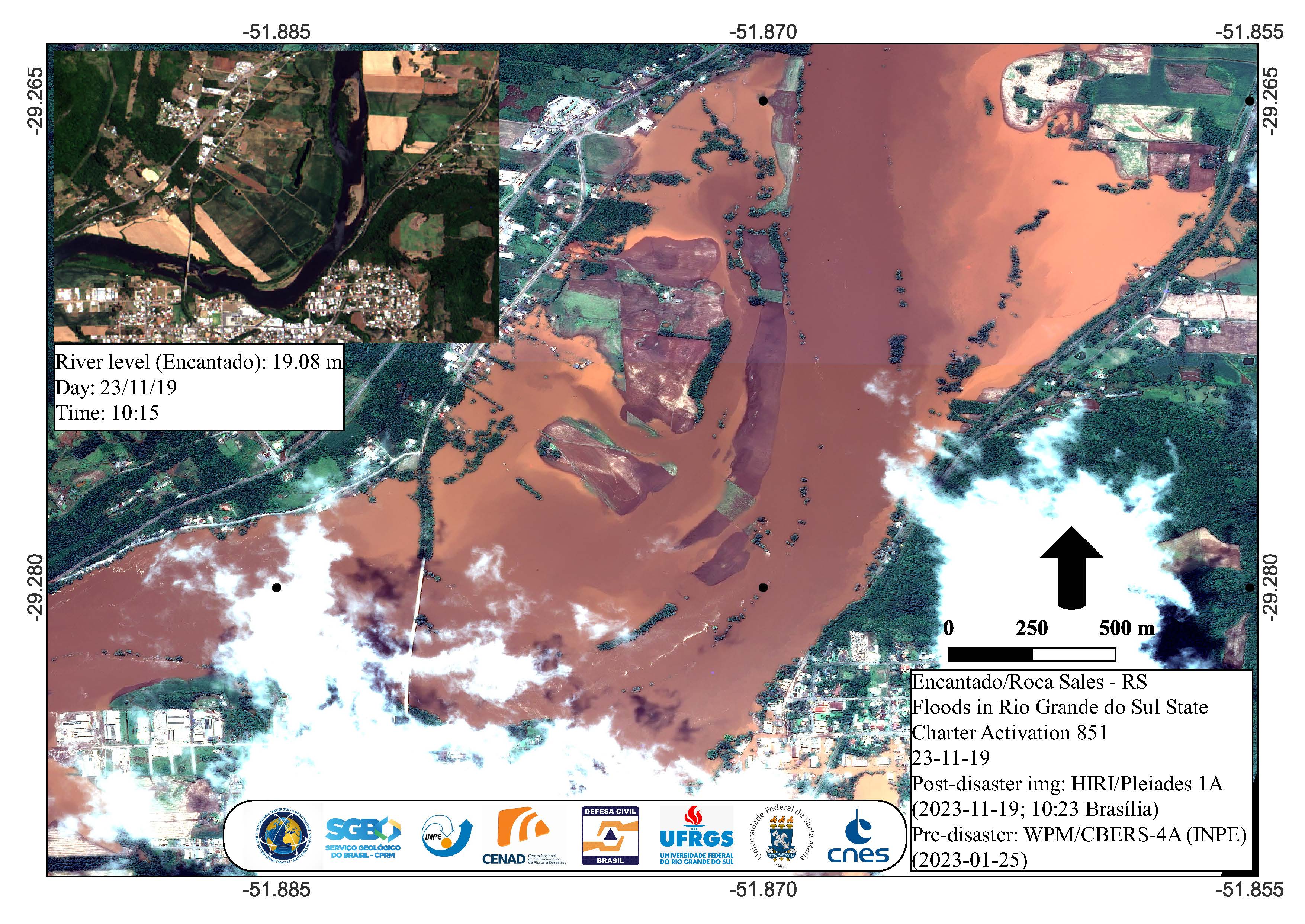
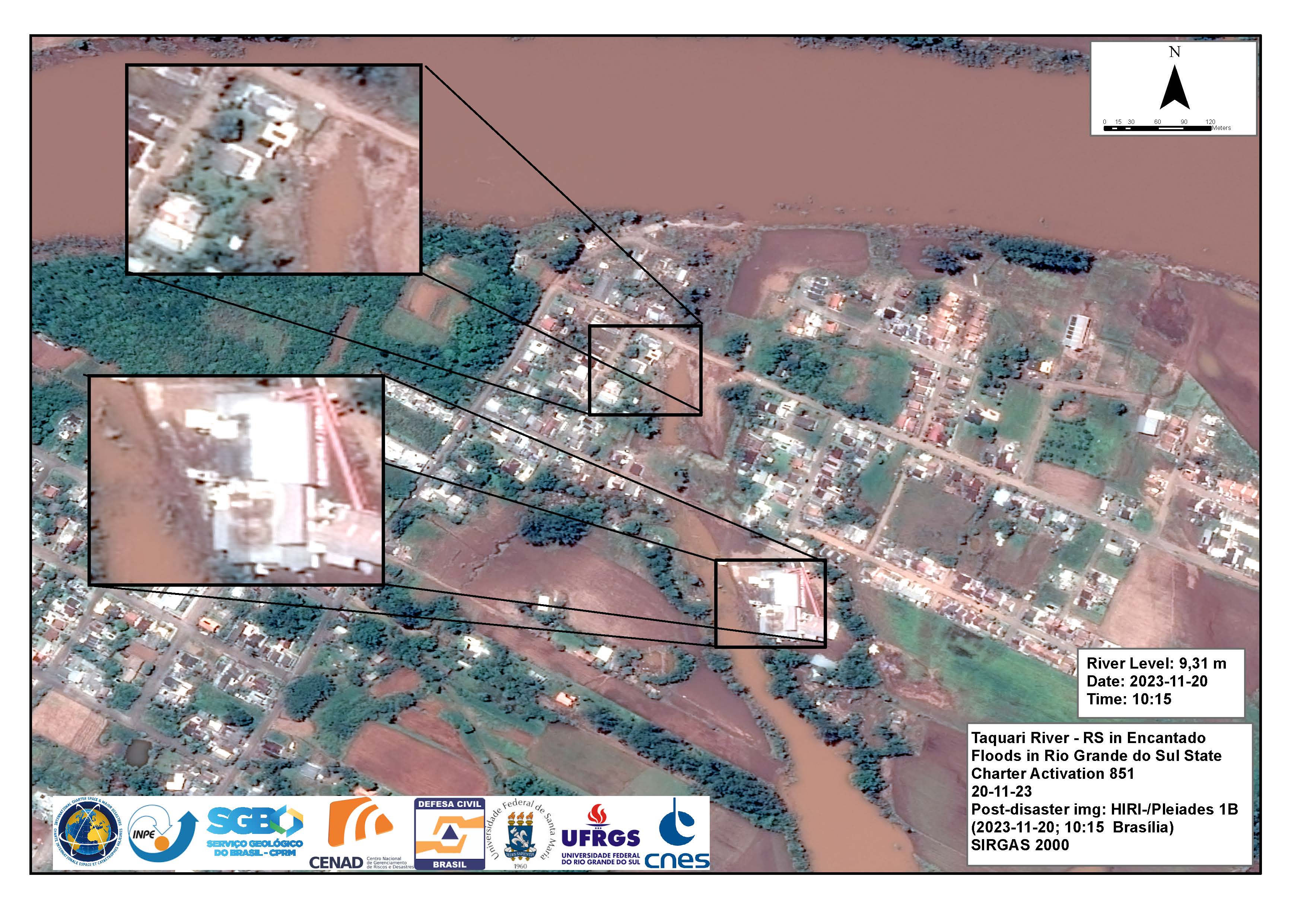
Large area affected by floods near Encantado and Roca Sales, Rio Grande do Sul State, Brazil
Copyright: CBERS-4 © (2023) INPE
Includes Pleiades material © CNES (2023), Distribution Airbus DS.
Map produced by INPE
Information about the Product
Acquired: CBERS-4: 25/01/2023
Pleiades: 19/11/2023
Source: CBERS-4 and Pleiades
Category: Reference Map
Areas affected by floods near Encantado and Roca Sales, Rio Grande do Sul State, Brazil
Copyright: CBERS-4 © (2023) INPE
Includes Pleiades material © CNES (2023), Distribution Airbus DS.
Map produced by INPE
Information about the Product
Acquired: CBERS-4: 25/01/2023
Pleiades: 19/11/2023
Source: CBERS-4 and Pleiades
Category: Reference Map
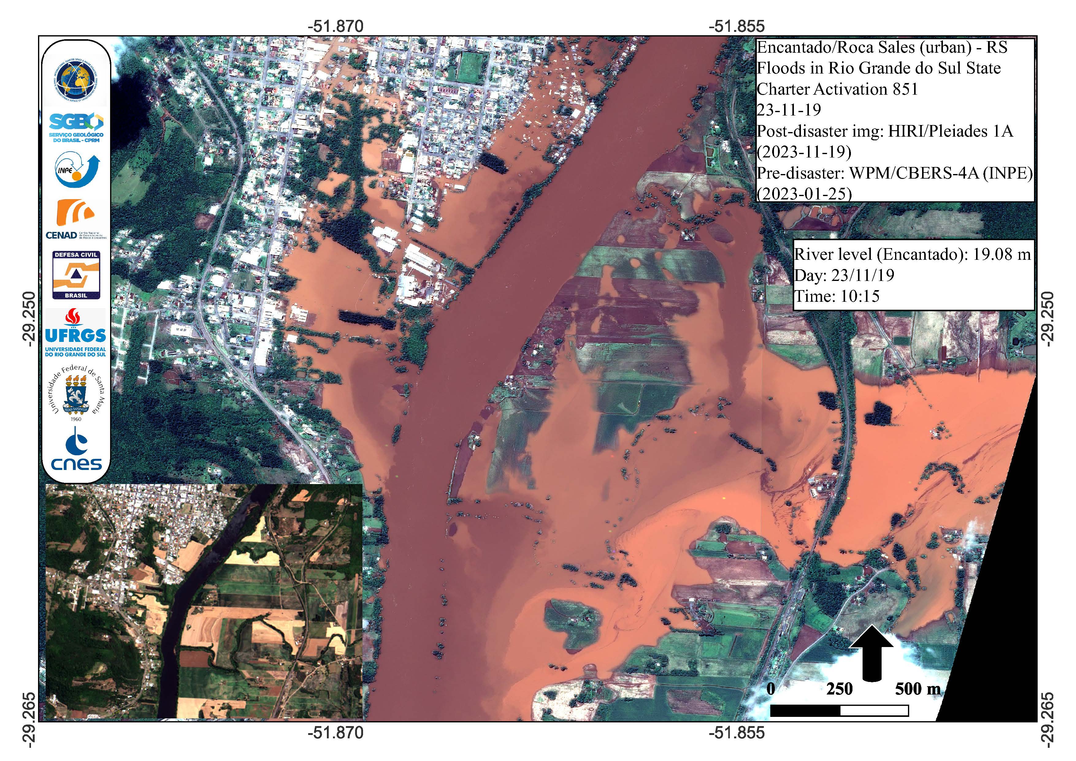
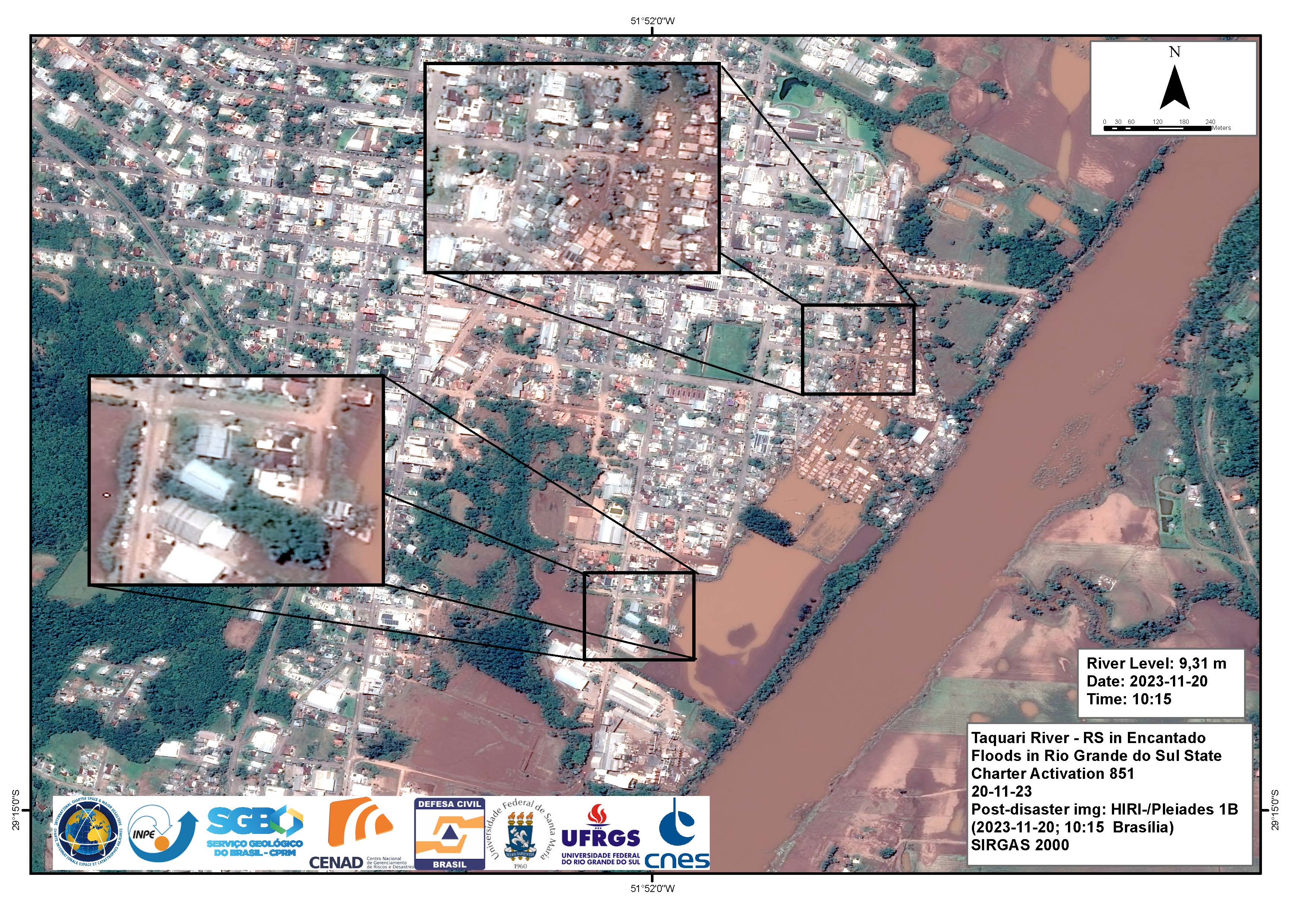
Urban areas affected by floods in Encantado and Roca Sales, Rio Grande do Sul State, Brazil
Copyright: Includes Pleiades material © CNES (2023), Distribution Airbus DS.
copyright (2023) INPE
Map produced by INPE
Information about the Product
Acquired: CBERS-4: 25/01/2023
Pleiades: 19/11/2023
Source: CBERS-4 and Pleiades
Category: Reference Map
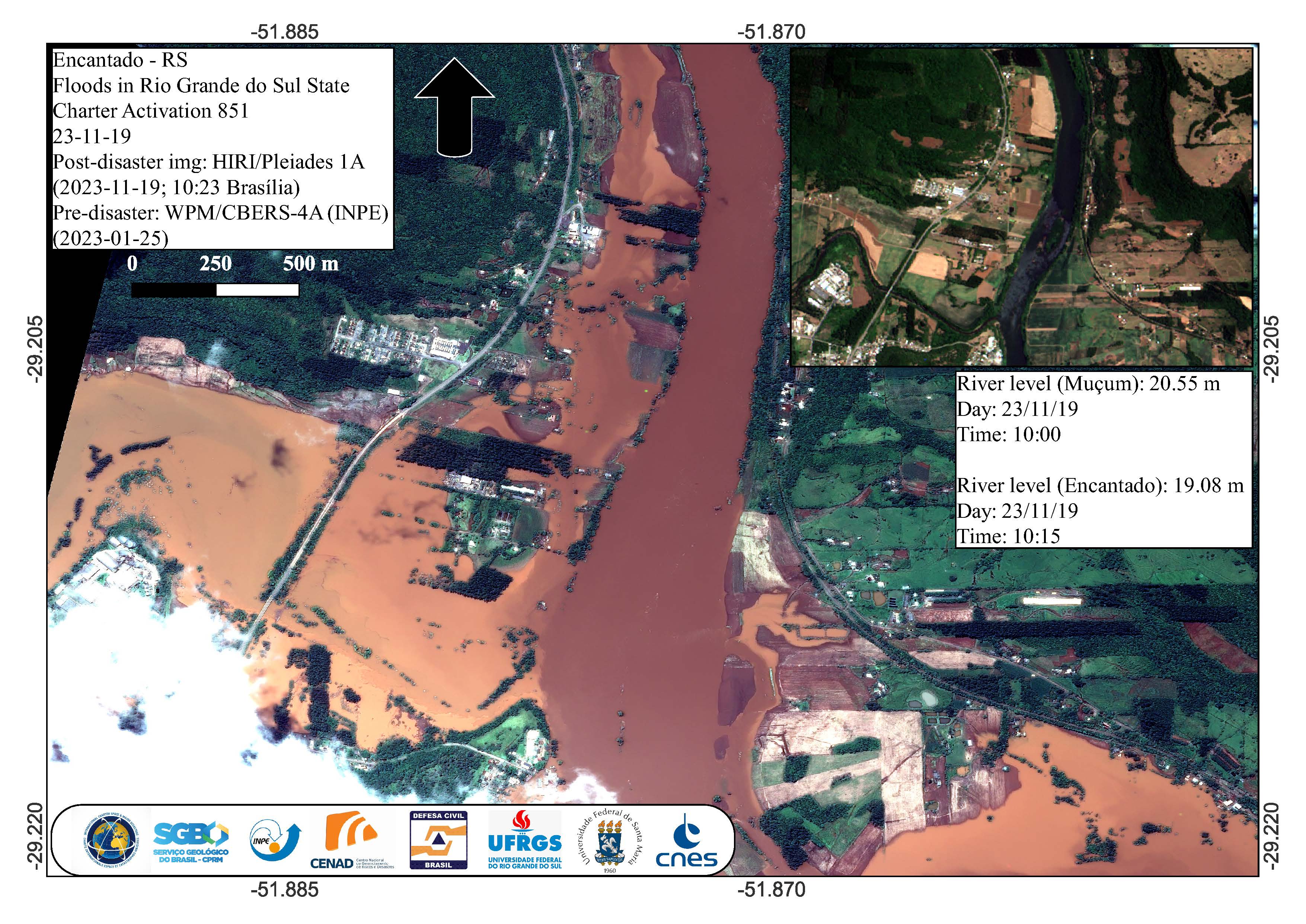
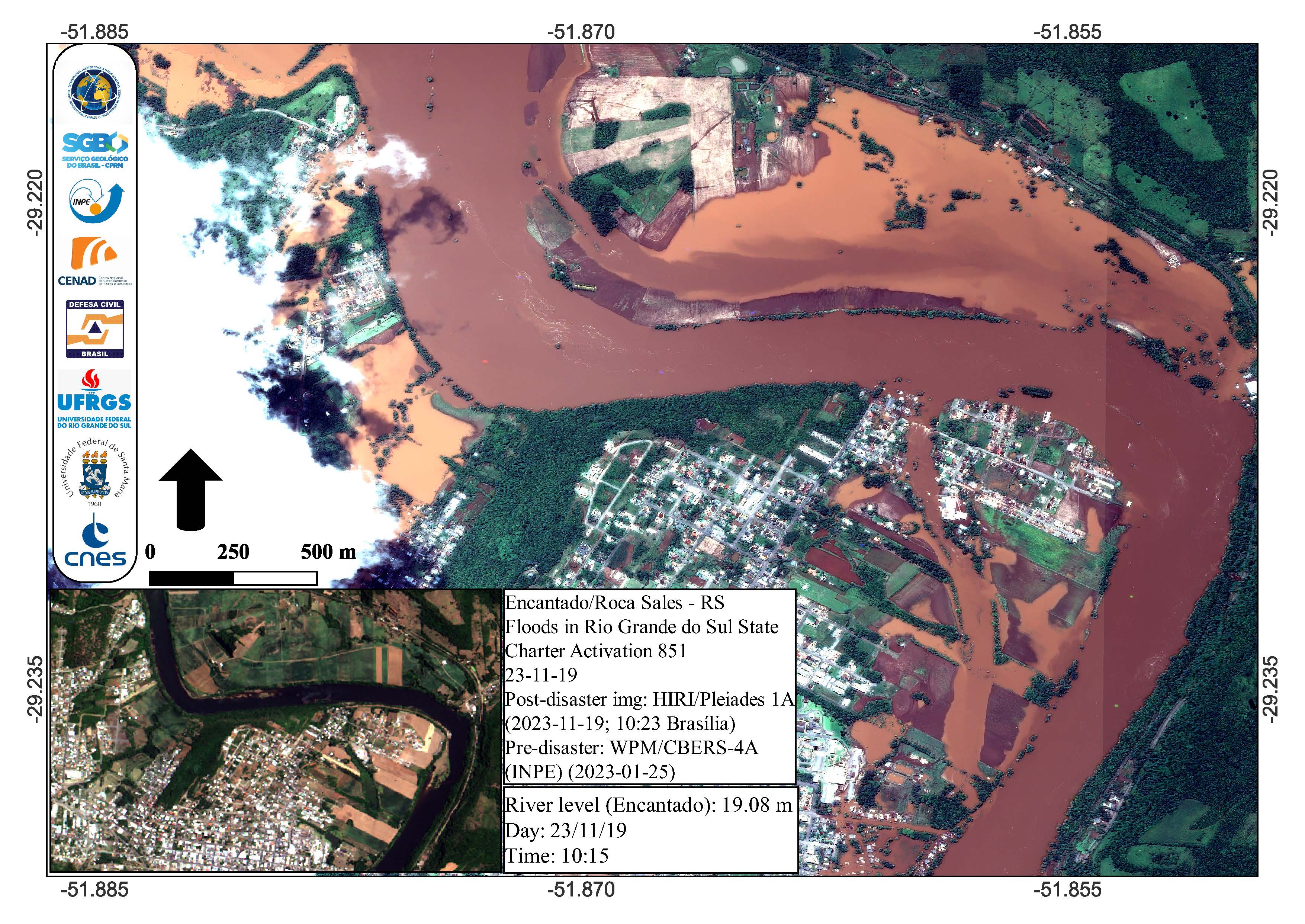
Areas affected by floods in Encantado, Rio Grande do Sul State, Brazil
Copyright: CBERS-4 © (2023) INPE
Includes Pleiades material © CNES (2023), Distribution Airbus DS.
Map produced by INPE
Information about the Product
Acquired: CBERS-4: 25/01/2023
Pleiades: 19/11/2023
Source: CBERS-4 and Pleiades
Category: Reference Map
Areas affected by floods near Muçum and Encantado, Rio Grande do Sul State, Brazil
Copyright: CBERS-4 © (2023) INPE
Includes Pleiades material © CNES (2023), Distribution Airbus DS.
Map produced by INPE
Information about the Product
Acquired: CBERS-4: 25/01/2023
Pleiades: 19/11/2023
Source: CBERS-4 and Pleiades
Category: Reference Map
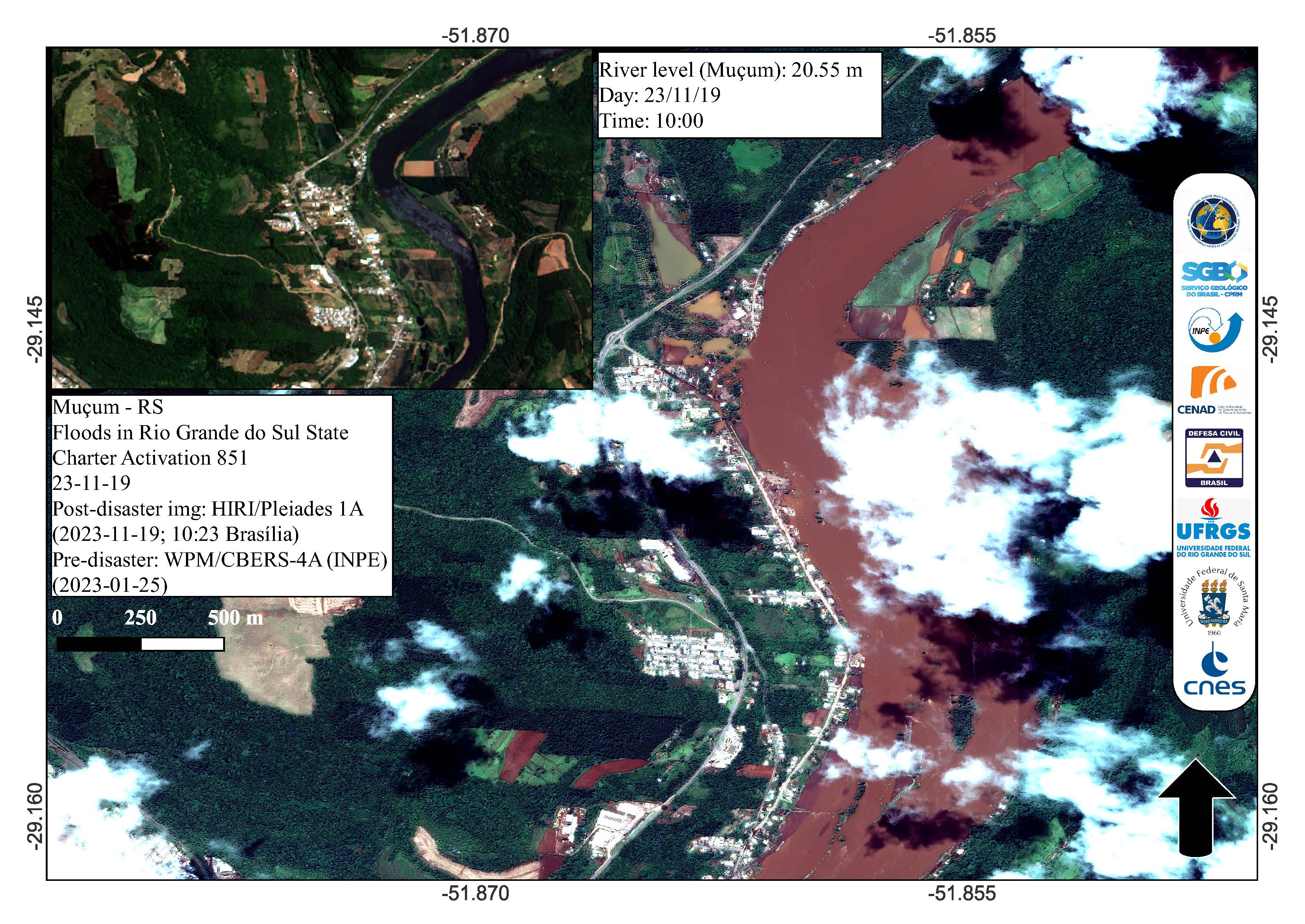
Areas affected by floods near Muçum, Rio Grande do Sul State, Brazil
Copyright: CBERS-4 © (2023) INPE
Includes Pleiades material © CNES (2023), Distribution Airbus DS.
Map produced by INPE
Information about the Product
Acquired: CBERS-4: 25/01/2023
Pleiades:19/11/2023
Source: CBERS-4 and Pleiades
Category: Reference Map

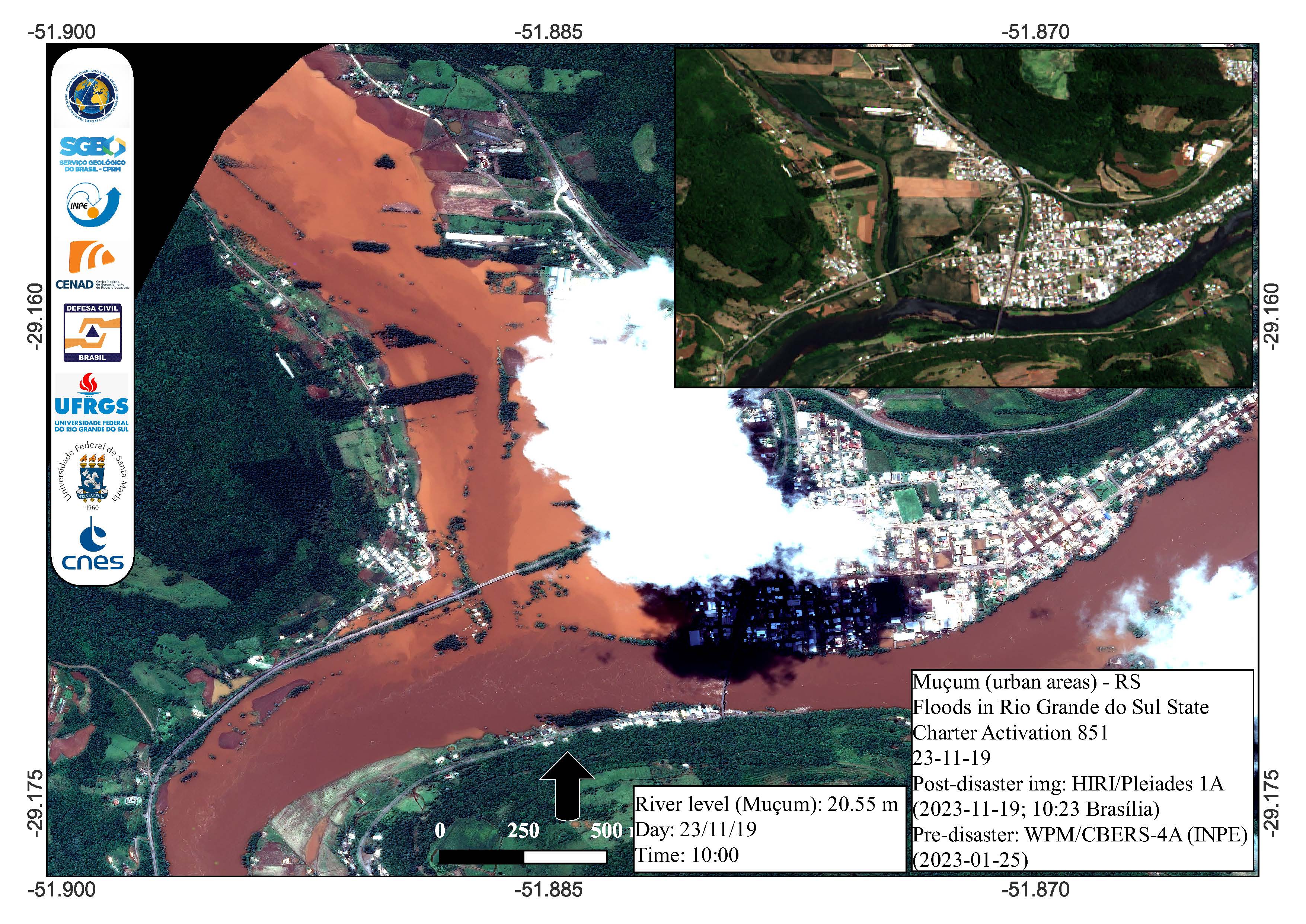
Urban areas affected by floods in Muçum, Rio Grande do Sul State, Brazil
Copyright: CBERS-4 © (2023) INPE
Includes Pleiades material © CNES (2023), Distribution Airbus DS.
Map produced by INPE
Information about the Product
Acquired: CBERS-4: 25/01/2023
Pleiades: 19/11/2023
Source: CBERS-4 and Pleiades
Category: Reference Map
 Back to the full activation archive

