 English
 Spanish
 French
 Chinese
 Russian
 Portuguese
 最新宪章启动
Charter activations
缅甸洪水
暴雨淹没了缅甸的大部分地区,缅甸14个州中12个州都受到影响,造成至少69人死亡,25万人无家可归。许多地区被洪水,涨潮和泥石流淹没了。
缅甸的三角洲地区的居民预计,随着北部雨水的不断增加,该地区的洪水水位将继续增加。在伊洛瓦底江三角洲地区的河流水位为0.6至1米,高于安全水位,预计将在未来几天继续上升15cm。
雨水对三角洲地区的影响是一个主要的水稻产区,当地的报道估计,1百万亩主要种植水稻的耕地被水淹没,6万5千多亩耕地已毁,令人担忧国家的粮食安全。
缅甸政府已经宣布四个地区:下巴,马圭省,实皆省和若开邦为灾区,并请求国际援助协助救援工作。
| 事件类型: | 洪水 |
| 事件地点: | 缅甸 |
| 启动宪章的日期: | 2015年8月5日 |
| 宪章启动时间: | 17:00:00 |
| 宪章启动时区: | UTC+02:00 |
| 宪章要求者: | UNITAR/UNOSAT代表缅甸UNDP |
| 项目经理: | UNITAR/UNOSAT |
Products
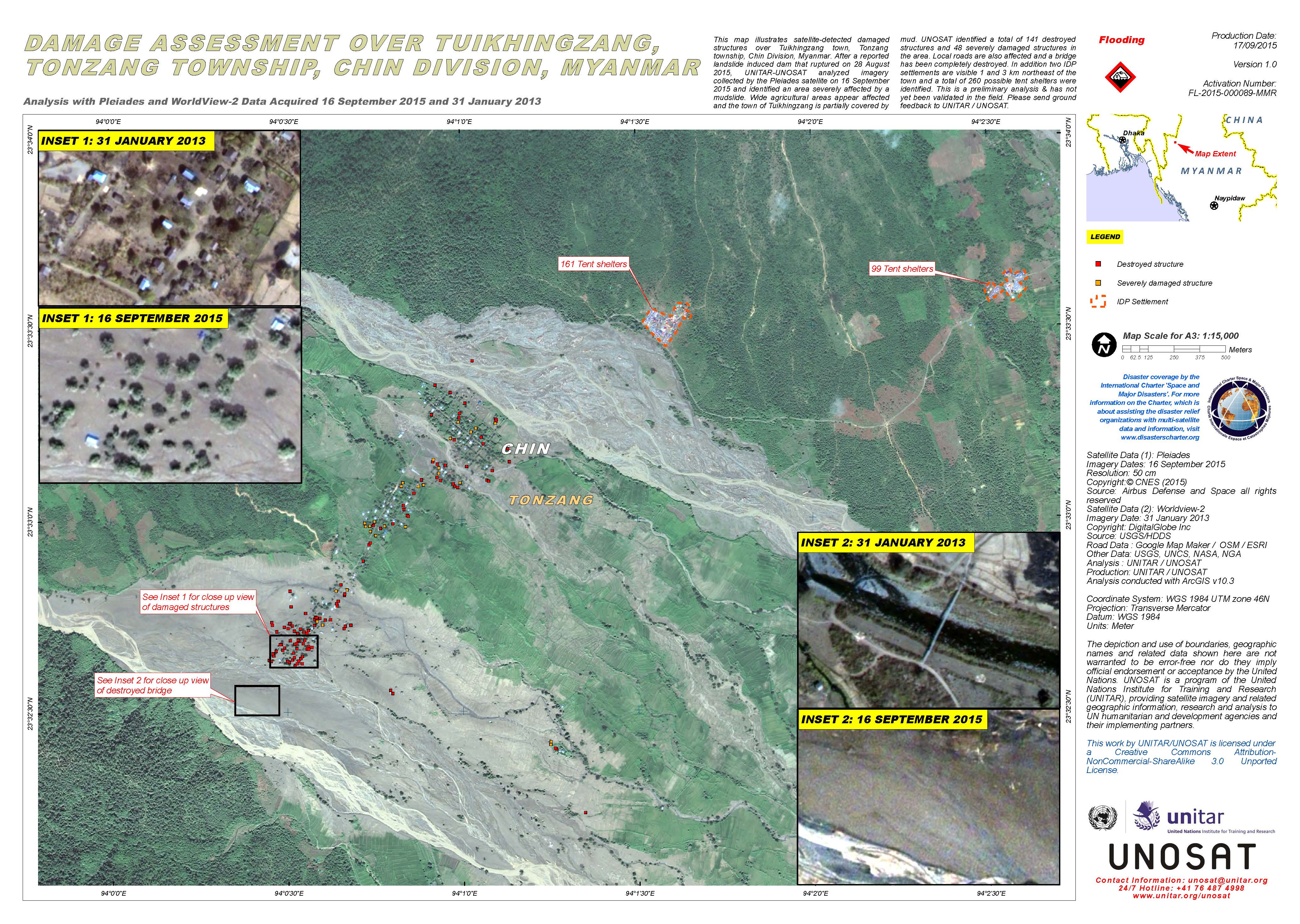
Damage assessment over Tuikhingzang and Tonzang township, Chin Division, Myanmar
版权: Pleiades © CNES 2015 - Distribution: Airbus Defence and Space, all rights reserved
WorldView-2 © DigitalGlobe Inc.
Map produced by UNITAR/UNOSAT
Information about the Product
已获得: Pleiades: 16/09/2015
WorldView-2: 31/01/2013
源: Pleiades / WorldView-2
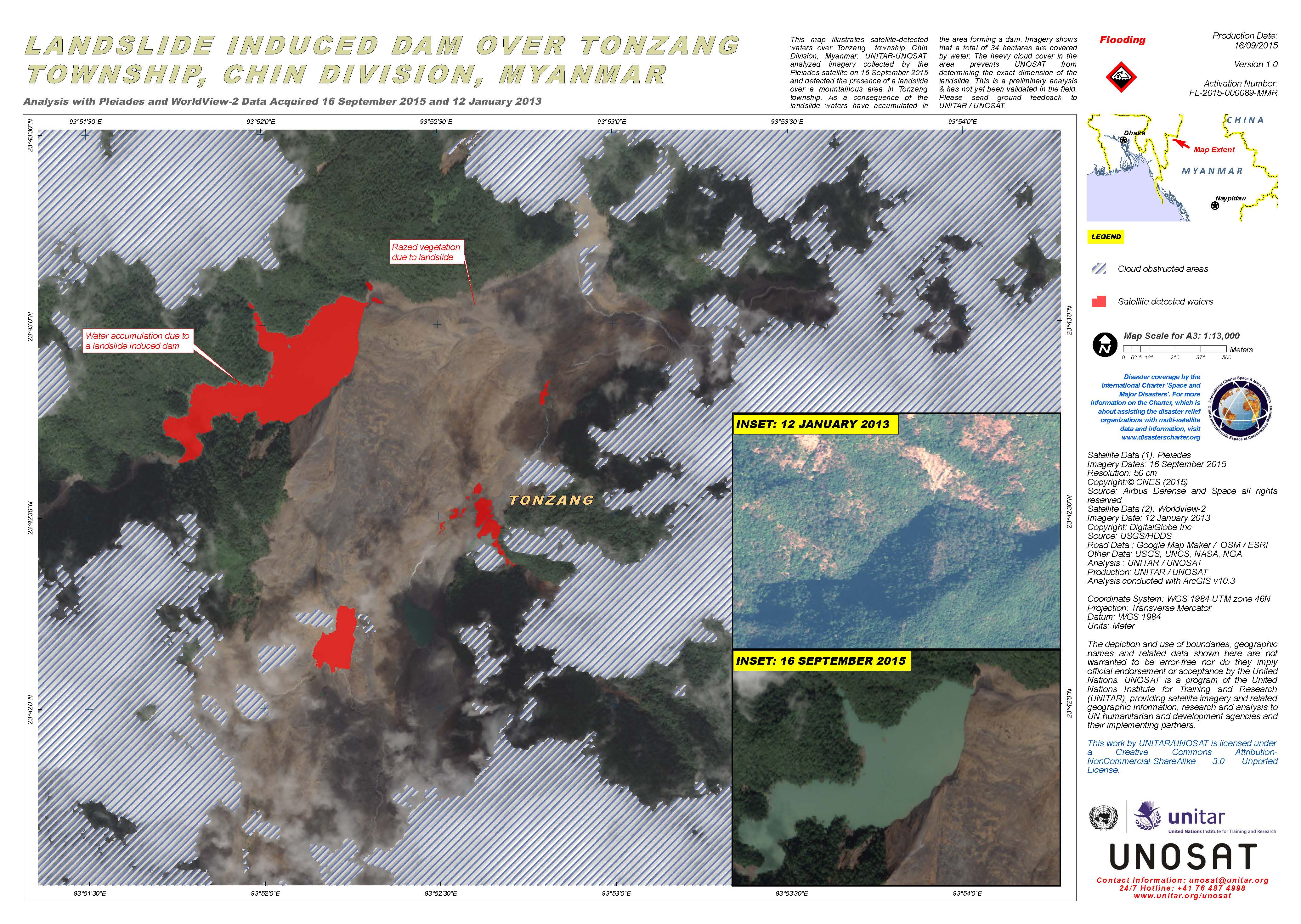
Landslide induced dam over Tonzang township, Chin Division, Myanmar
版权: Pleiades © CNES 2015 - Distribution: Airbus Defence and Space, all rights reserved
WorldView-2 © DigitalGlobe Inc.
Map produced by UNITAR/UNOSAT
Information about the Product
已获得: Pleiades: 16/09/2015
WorldView-2: 12/01/2013
源: Pleiades / WorldView-2
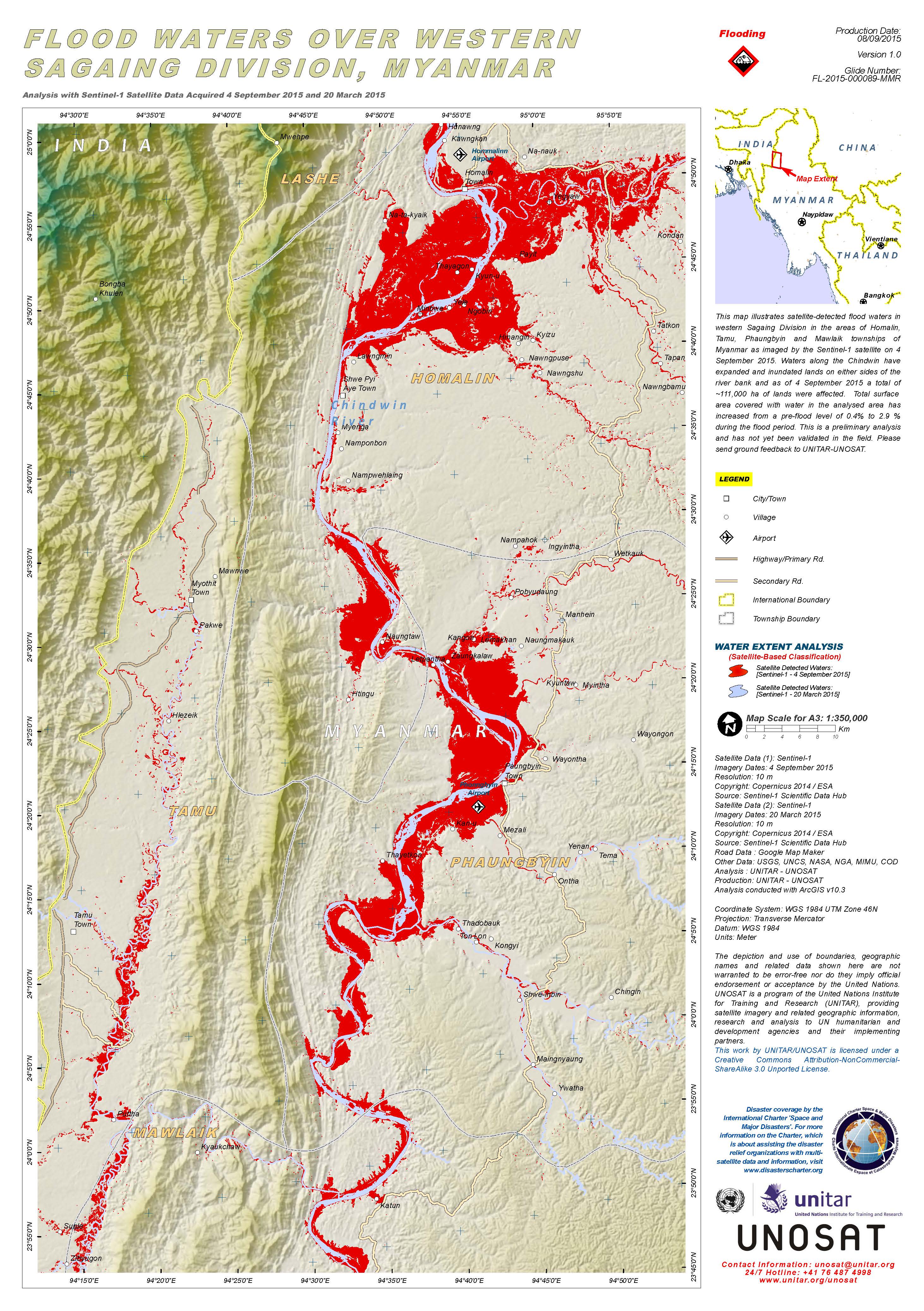
Flood waters over western Sagaing Division, Myanmar
版权: Copernicus Sentinel data 2015 / ESA
Map produced by UNITAR/UNOSAT
Information about the Product
已获得: Pre-disaster: 20/03/2015
Post-disaster: 04/09/2015
源: Sentinel-1
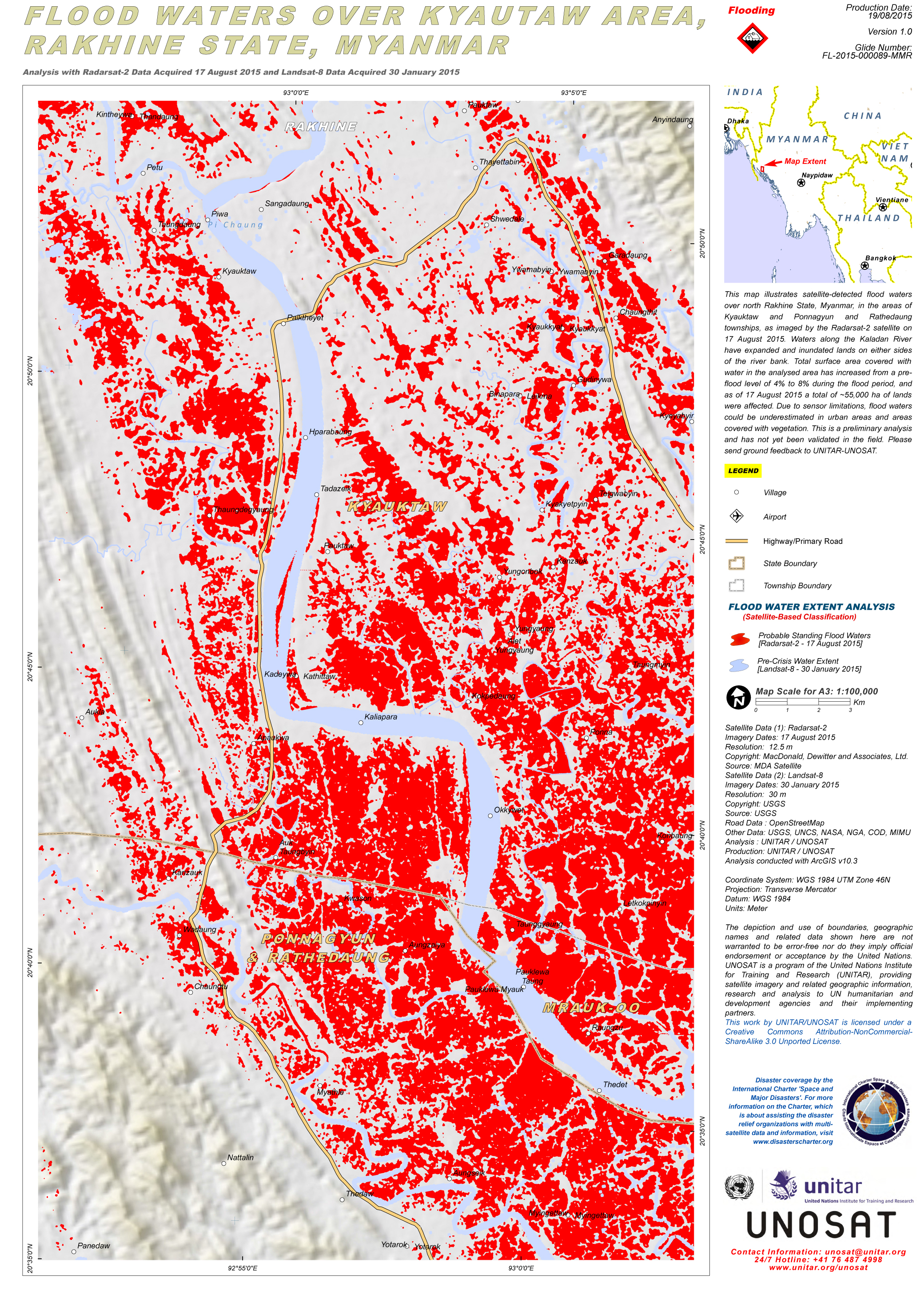
Flood waters over Kyautaw area, Rakhine State, Myanmar
版权: RADARSAT-2 Data and Products © MacDonald, Dettwiler and Associates Ltd. (2015) - All Rights Reserved. RADARSAT is an official trademark of the Canadian Space Agency.
Landsat 8 data and products © USGS (2015) - All rights reserved
Map produced by UNITAR/UNOSAT
Information about the Product
已获得: RADARSAT-2: 17/08/2015
Landsat 8: 30/01/2015
源: RADARSAT-2 / Landsat 8
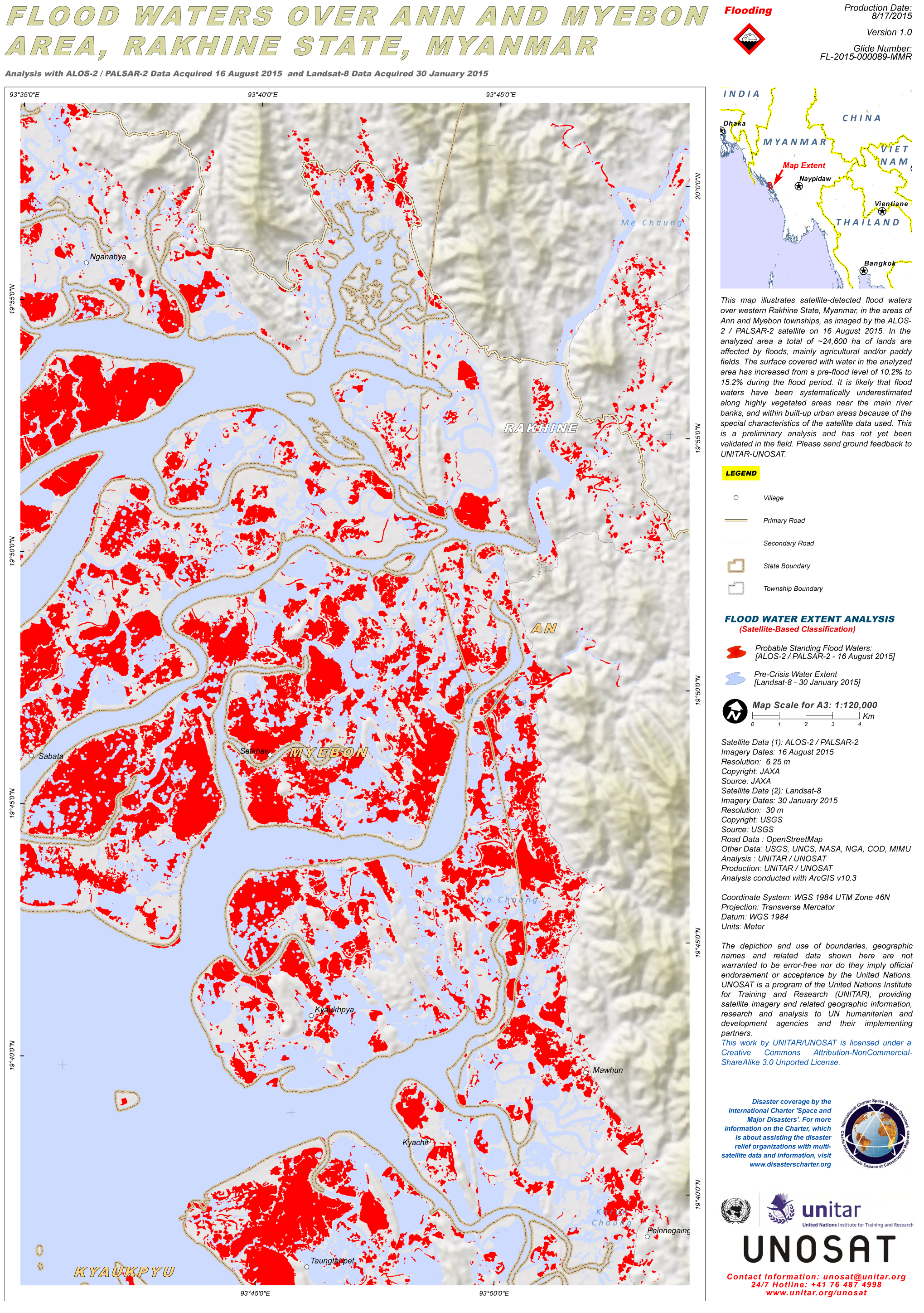
Flood waters over Ann and Myebon area, Rakhine State, Myanmar
版权: ALOS-2 © JAXA 2015
Landsat 8 data and products © USGS (2015) - All rights reserved
Map produced by UNITAR/UNOSAT
Information about the Product
已获得: ALOS-2 / PALSAR-2: 16/08/2015
Landsat 8: 30/01/2015
源: ALOS-2 / PALSAR-2 / Landsat 8
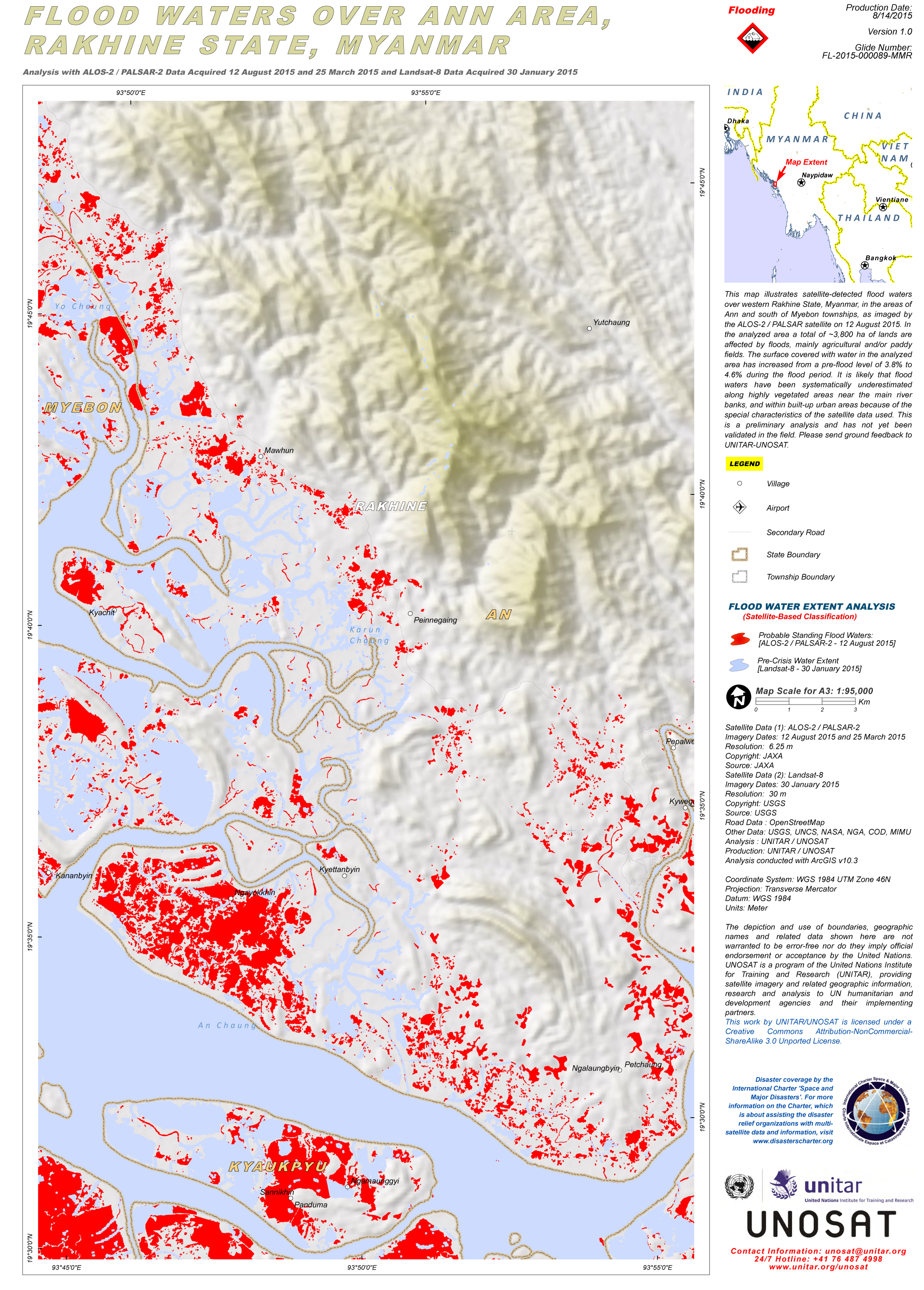
Flood waters over Ann Area, Rakhine State, Myanmar
版权: ALOS-2 © JAXA 2015
Landsat 8 data and products © USGS (2015) - All rights reserved
Map produced by UNITAR/UNOSAT
Information about the Product
已获得: ALOS-2 / PALSAR-2: 25/03/2015 & 12/08/2015
Landsat 8: 30/01/2015
源: ALOS-2 / PALSAR-2 / Landsat-8
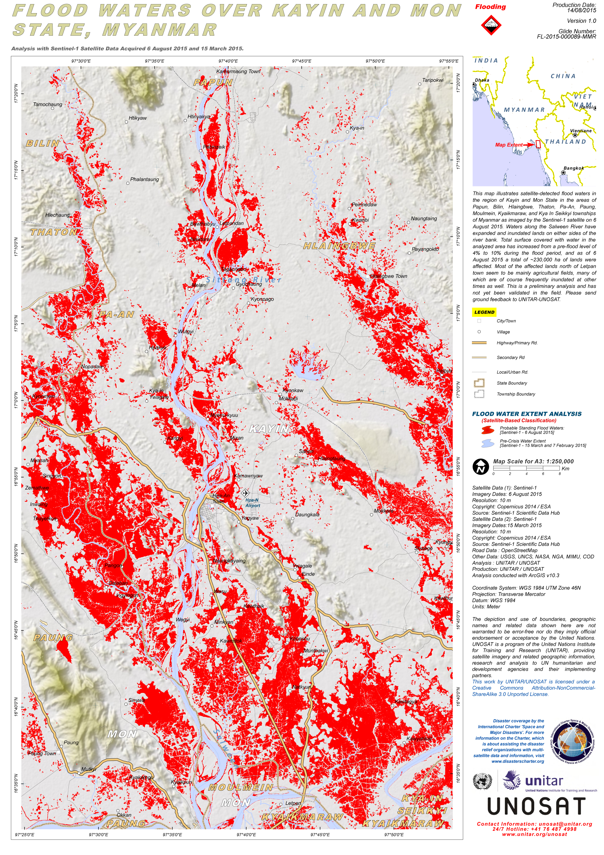
Flood waters over Kayin and Mon State, Myanmar
版权: Copernicus Sentinel data 2015 / ESA
Map produced by UNITAR/UNOSAT
Information about the Product
已获得: Pre-disaster: 15/03/2015
Post-disaster: 06/08/2015
源: Sentinel-1
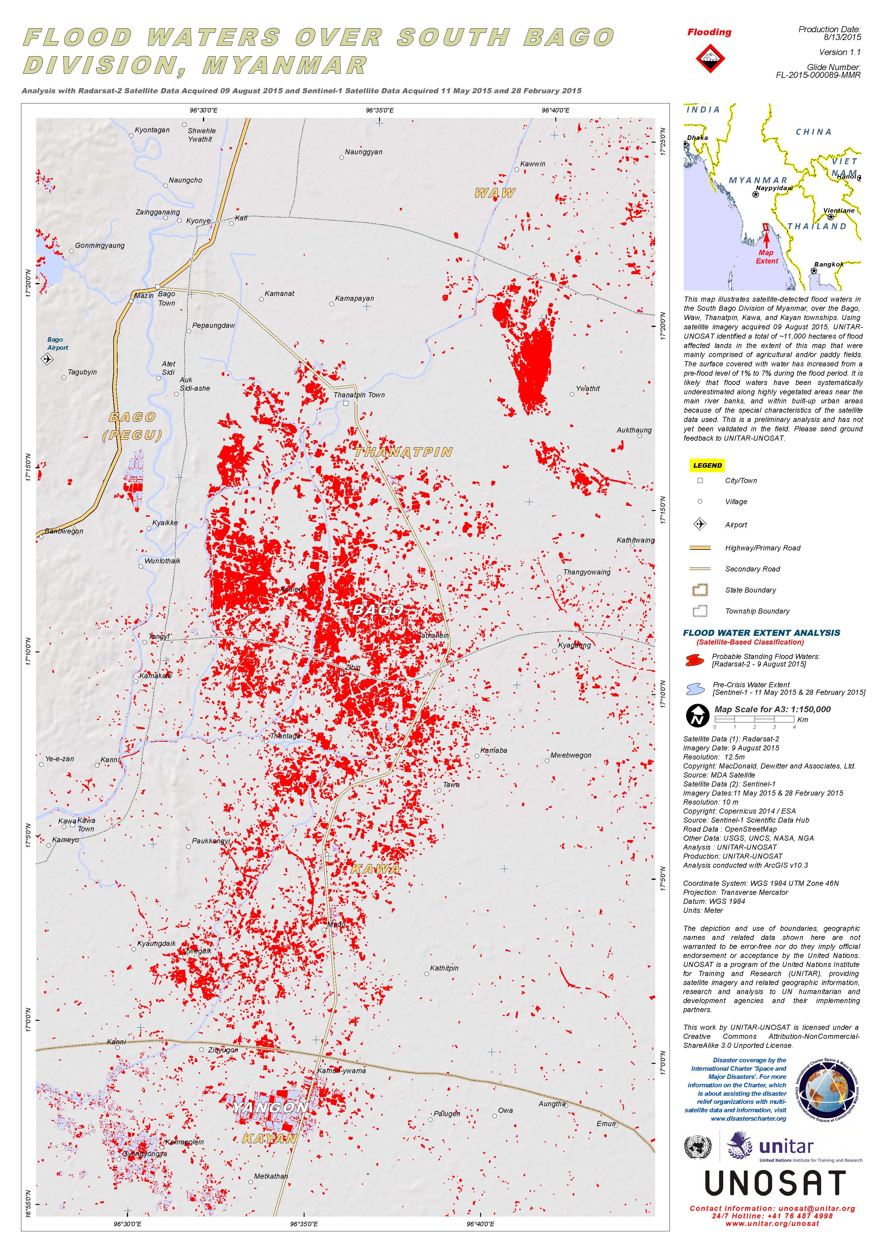
Flood waters over South Bago Division, Myanmar
版权: RADARSAT-2 Data and Products © MacDonald, Dettwiler and Associates Ltd. (2015) - All Rights Reserved. RADARSAT is an official trademark of the Canadian Space Agency.
Sentinel-1A © Copernicus Sentinel data 2015 / ESA
Map produced by UNITAR/UNOSAT
Information about the Product
已获得: RADARSAT-2: 09/08/2015
Sentinel-1: 11/05/2015 and 28/02/2015
源: RADARSAT-2 / Sentinel-1
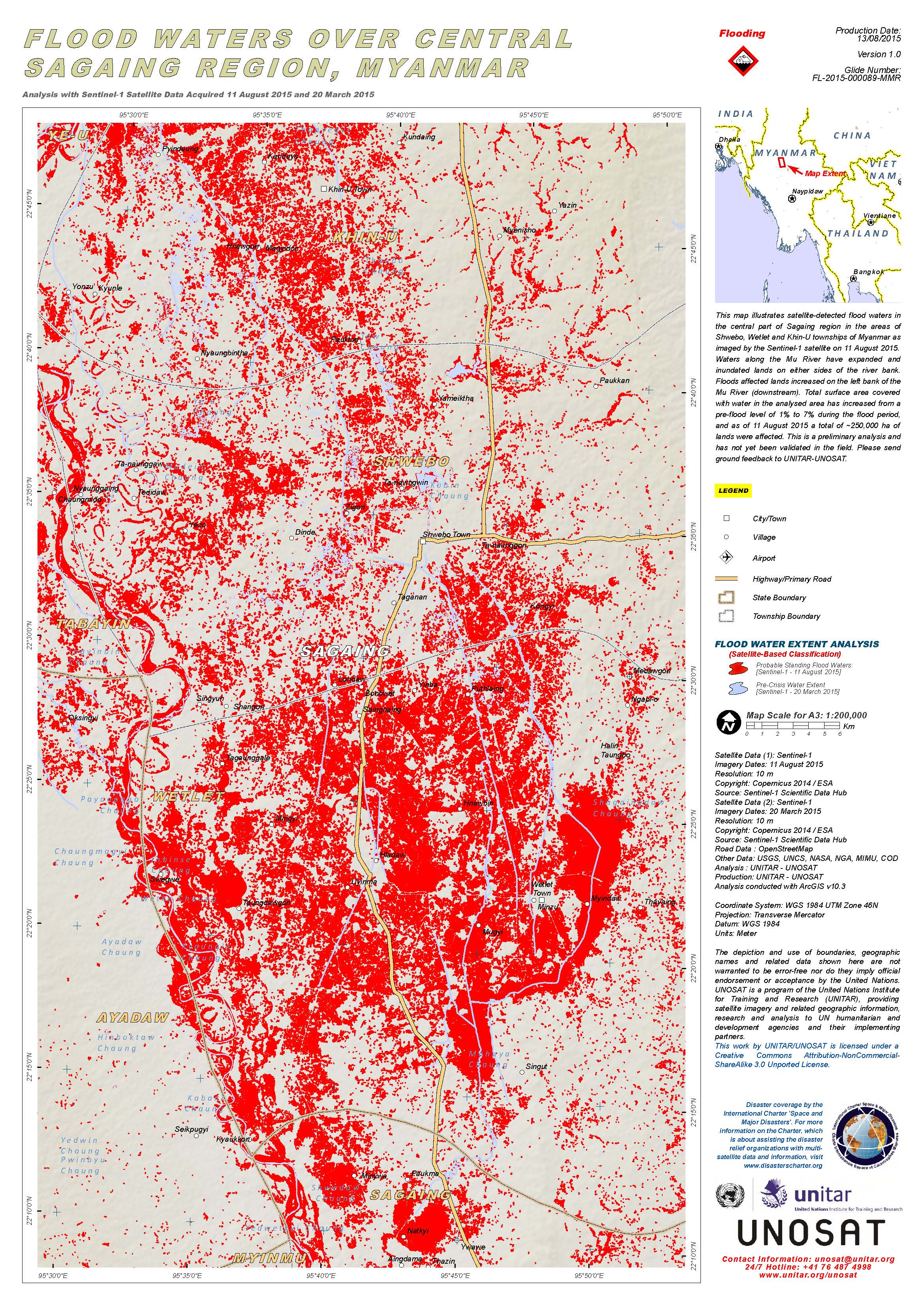
Flood waters over central Sagaing Region, Myanmar
版权: Copernicus Sentinel data 2015 / ESA
Map produced by UNITAR/UNOSAT
Information about the Product
已获得: Pre-disaster: 20/03/2015
Post-disaster: 11/08/2015
源: Sentinel-1
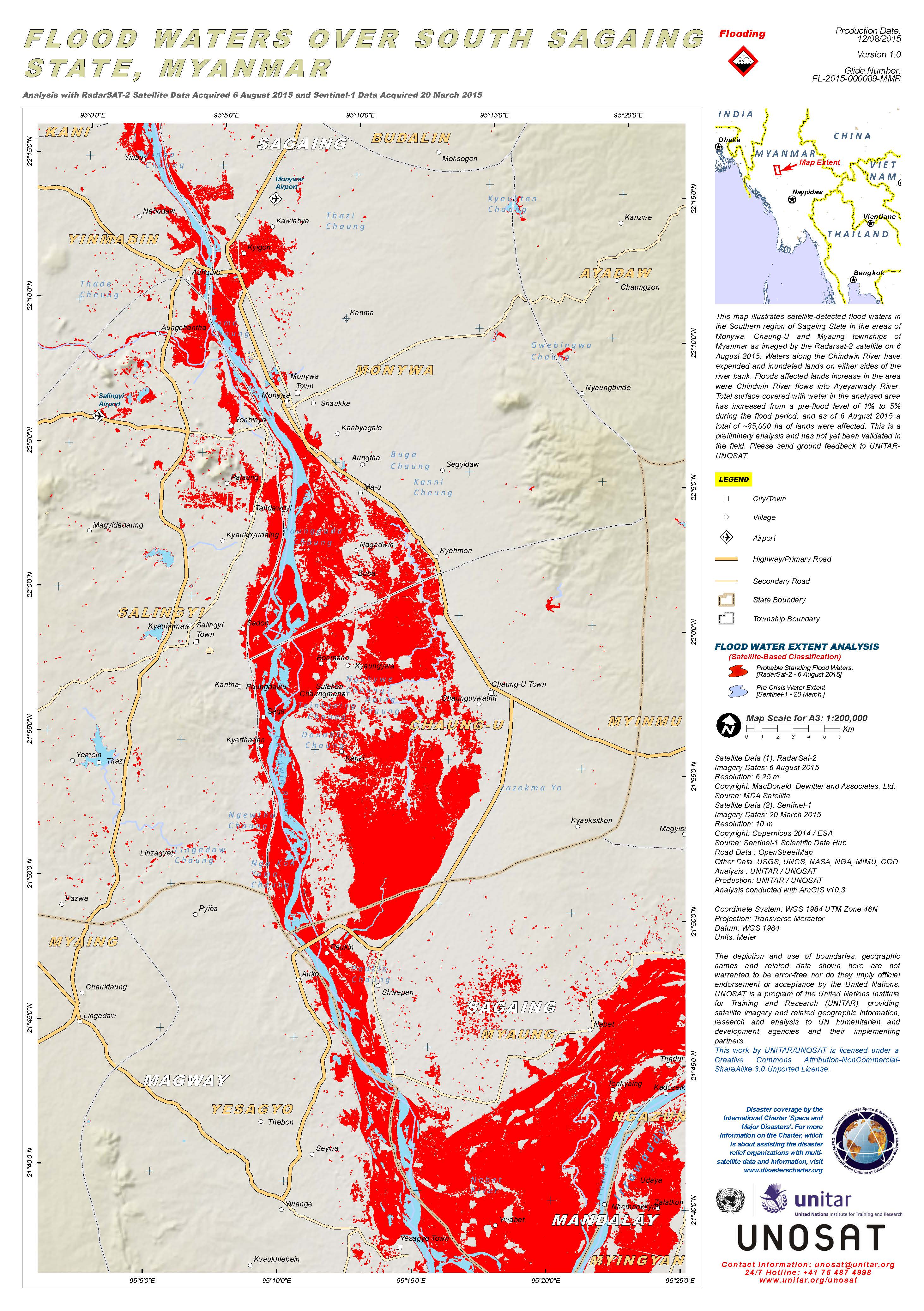
Flood waters over south Sagaing State, Myanmar
版权: RADARSAT-2 Data and Products © MacDonald, Dettwiler and Associates Ltd. (2015) - All Rights Reserved. RADARSAT is an official trademark of the Canadian Space Agency.
Sentinel-1A © Copernicus Sentinel data 2015 / ESA
Map produced by UNITAR/UNOSAT
Information about the Product
已获得: RADARSAT-2: 06/08/2015
Sentinel-1: 20/03/2015
源: RADARSAT-2 / Sentinel-1
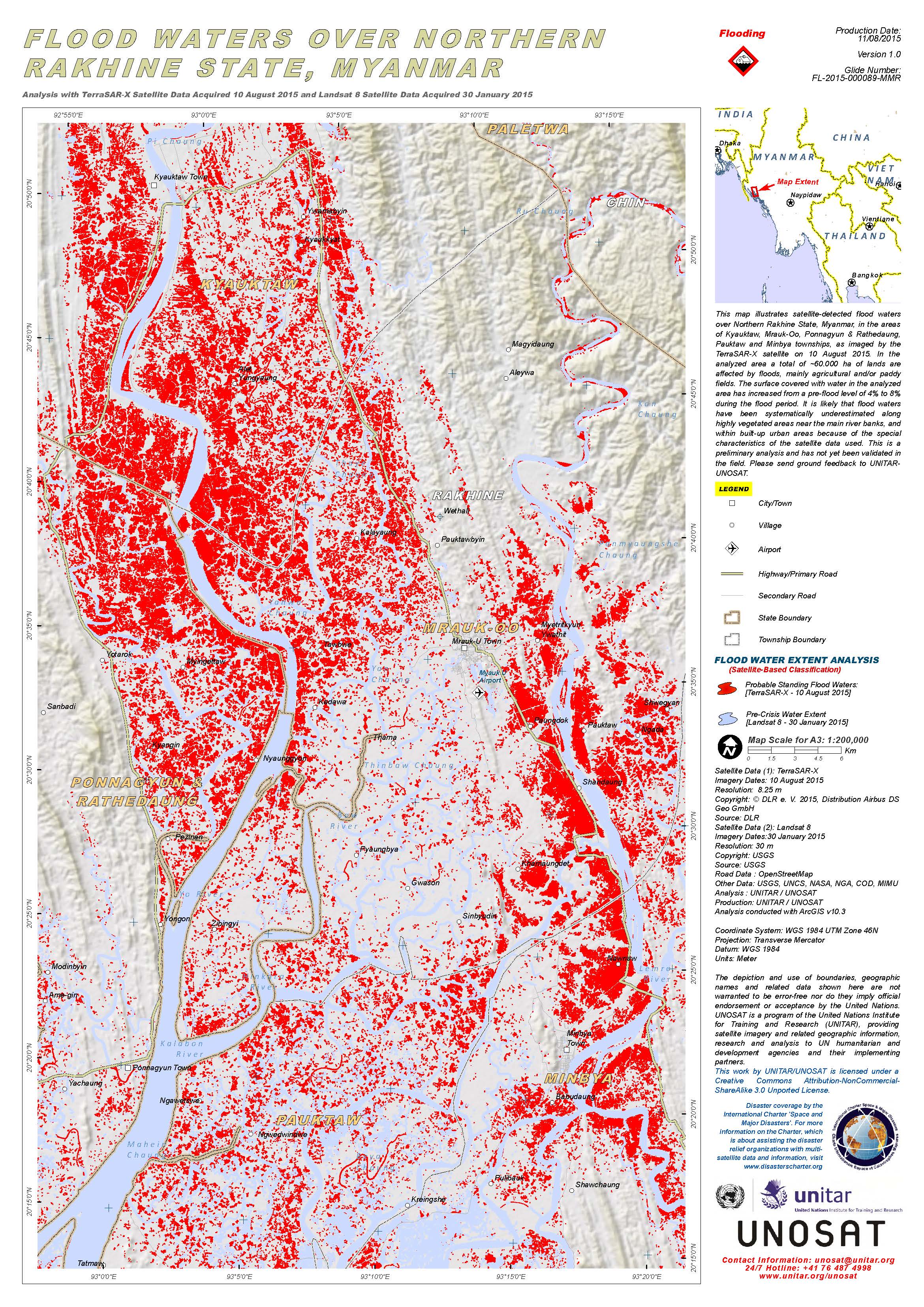
Flood waters over Northern Rakhine State, Myanmar
版权: TerraSAR-X © DLR e. V. 2015, Distribution Airbus DS Geo GmbH
Landsat 8 data and products © USGS (2015) - All rights reserved
Map produced by UNITAR/UNOSAT
Information about the Product
已获得: TerraSAR-X: 10/08/2015
Landsat 8: 30/01/2015
源: TerraSAR-X / Landsat 8
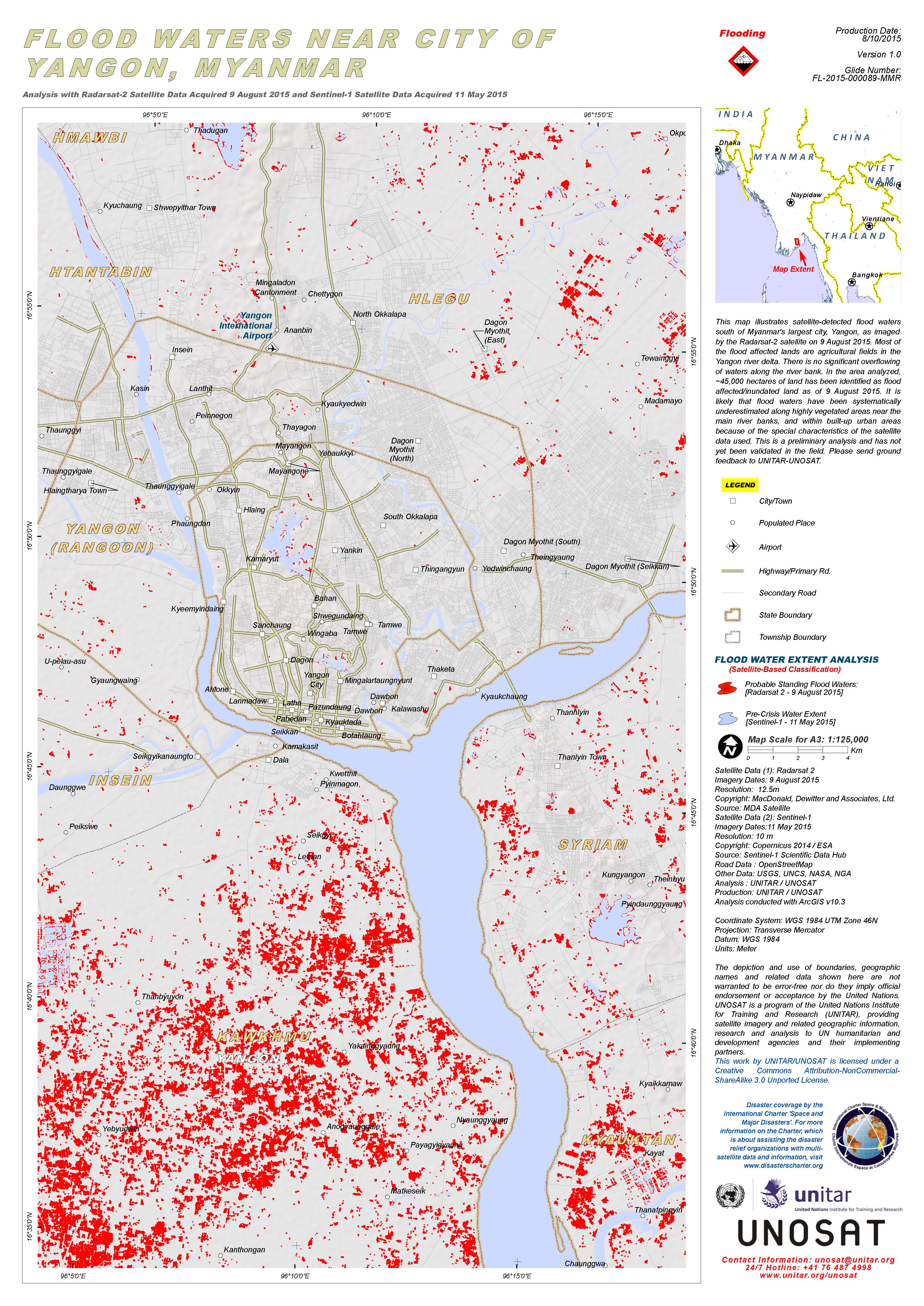
Flood waters near the city of Yangon, Myanmar
版权: RADARSAT-2 Data and Products © MacDonald, Dettwiler and Associates Ltd. (2015) - All Rights Reserved. RADARSAT is an official trademark of the Canadian Space Agency.
Sentinel-1 © Copernicus Sentinel data 2015 / ESA
Map produced by UNITAR/UNOSAT
Information about the Product
已获得: RADARSAT-2: 09/08/2015
Sentinel-1: 11/05/2015
源: RADARSAT-2 / Sentinel-1
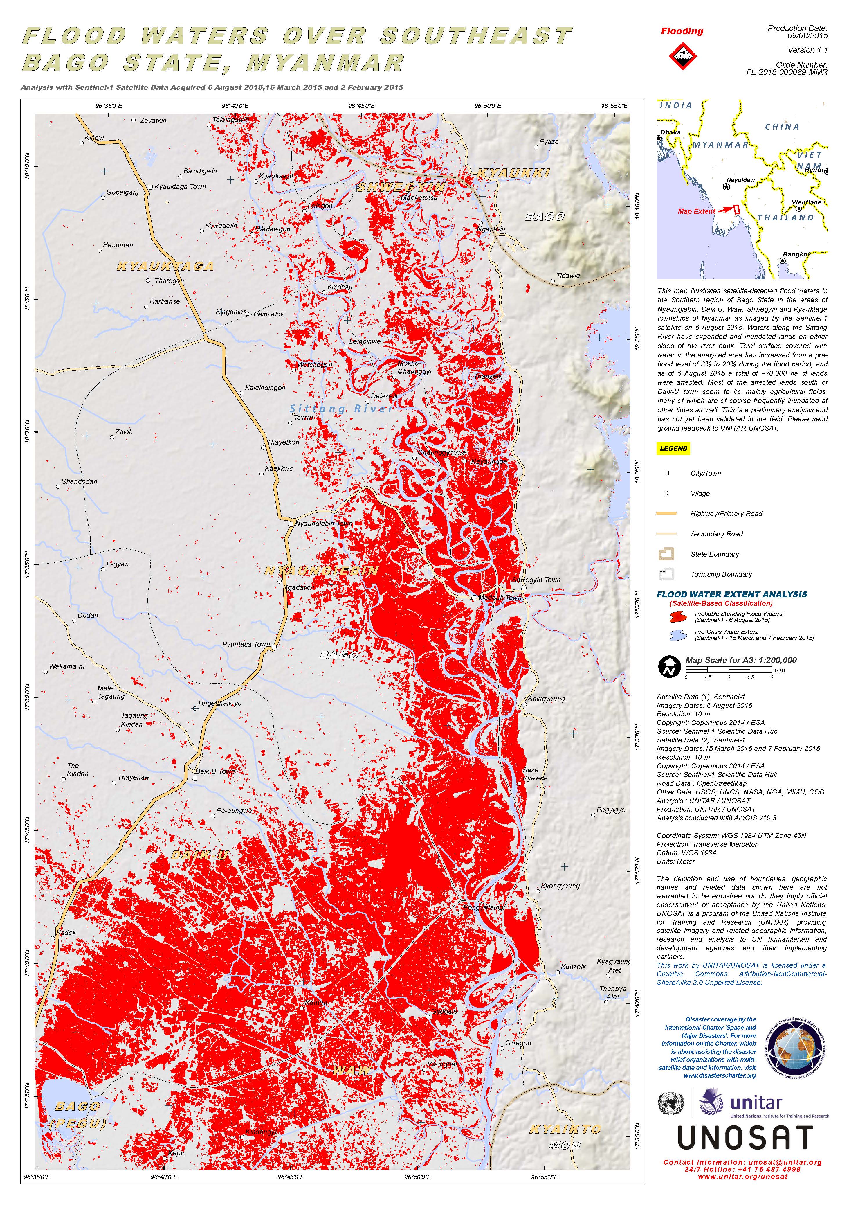
Flood waters over southeast Bago State, Myanmar
版权: Copernicus Sentinel data 2015 / ESA
Map produced by UNITAR/UNOSAT
Information about the Product
已获得: Pre-disaster: 07/02/2015 and 15/03/2015
Post-disaster: 06/08/2015
源: Sentinel-1
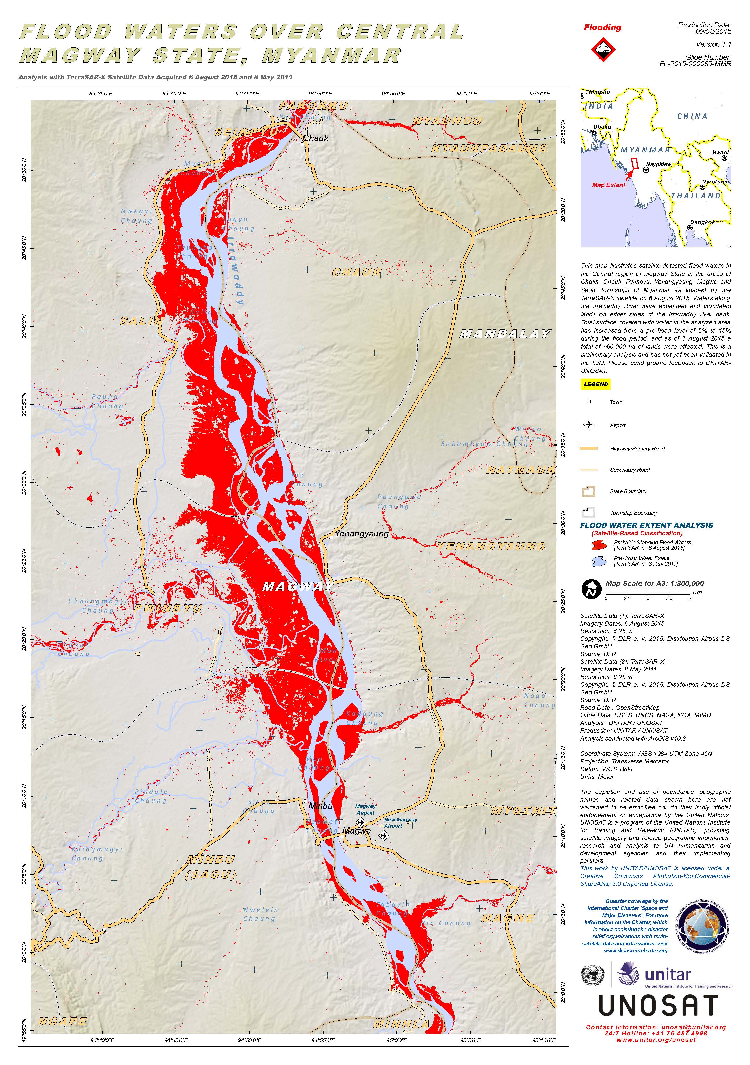
Flood waters over Central Magway State, Myanmar
版权: DLR e. V. 2015, Distribution Airbus DS Geo GmbH
Map produced by UNITAR/UNOSAT
Information about the Product
已获得: Pre-disaster: 08/05/2011
Post-disaster: 06/08/2015
源: TerraSAR-X
 返回完整的响应档案

