 English
 Spanish
 French
 Chinese
 Russian
 Portuguese
 Последняя Активация
Charter activations
Flood and landslide in Myanmar
The Northern Rakhine State in Myanmar is facing continuous rains that have flooded several areas including in Maungdaw and Buthidaung. The Government has confirmed the death of 42 people Landslides have occurred in several places (in Buthidaung) and roads and bridges have either been cut or damaged by the floods in Maungdaw and Buthidaung. Several villages are severely flooded.
| Тип события: | Flood, Landslide |
| Место события: | Myanmar |
| Date of Charter Activation: | 17/06/2010 |
| Запрос на активацию поступил от: | UNITAR/UNOSAT on behalf of UNDP |
| Менеждер проекта от: | UNITAR/UNOSAT |
Products
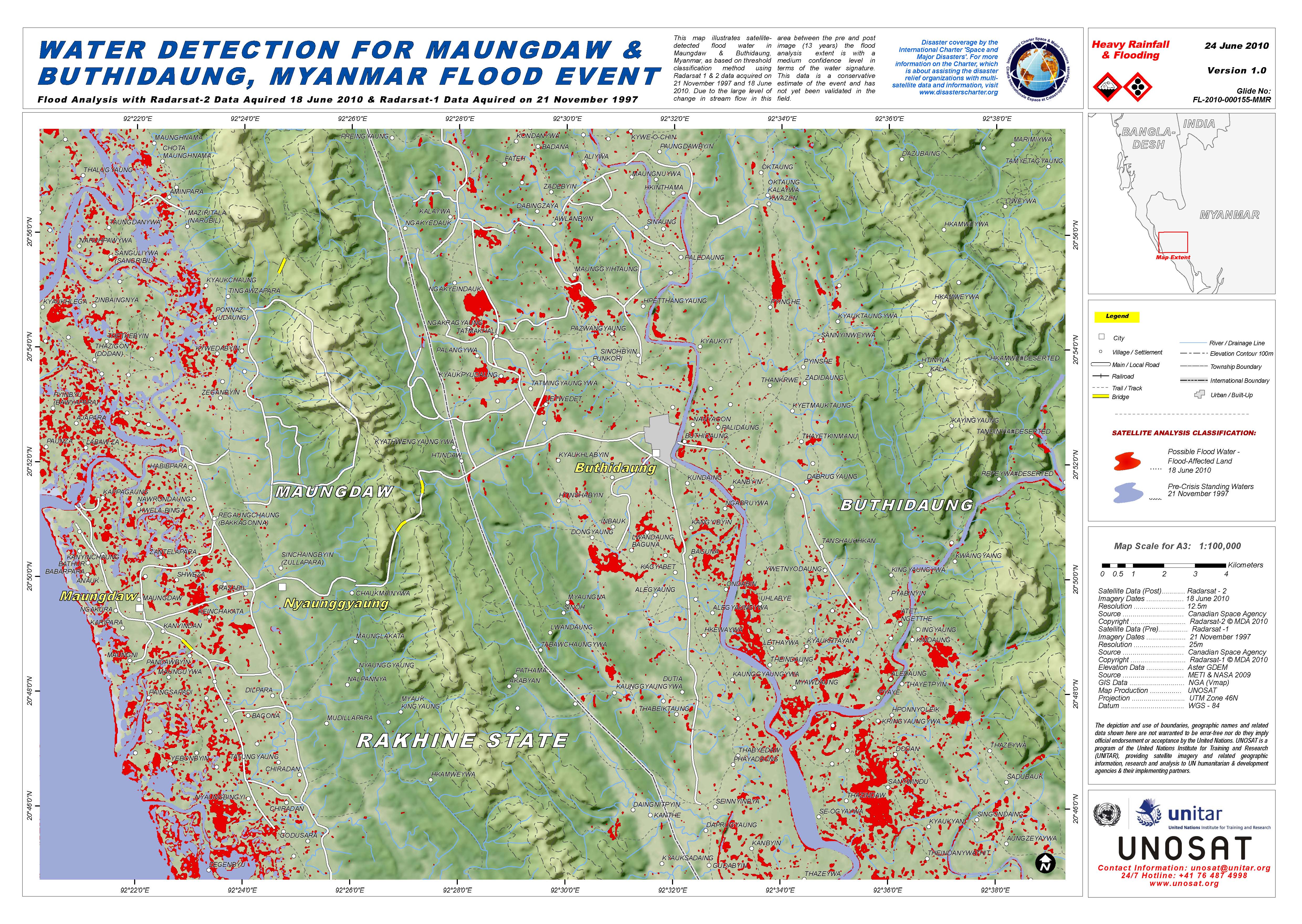
Water Detection for Maungdaw & Buthidaung, Myanmar Flood Event
Авторские права: UNOSAT
Information about the Product
Получено: 21/10/1997 & 18/06/2010.
Источник: Satellite Data (Post): Radarsat-2
Imagery Dates: 18 June 2010
Resolution: 12m
Source: Canadian Space Agency
Copyright: Radarsat-2 © MDA 2010
Satellite Data (Pre): Radarsat-1
Imagery Dates: 21 November 1997
Resolution: 25m
Source: Canadian Space Agency
Copyright: Radarsat-1 © MDA 2010
Elevation Data: Aster GDEM
Source: METI & NASA 2009
GIS Data: NGA (Vmap)
Map Production: UNOSAT
Projection: UTM Zone 46N

Situation Overview and Rainfall Estimate for Flood Affected Townships of Maungdaw and Buthidaung, Myanmar
Авторские права: UNOSAT
Information about the Product
Получено: 10th - 16th of June 2010
Источник: Rainfall Data: TRMM
Source: NASA
Dates: 10 - 16 June 2010
Elevation Data: Aster GDEM
Source: METI & NASA 2009
GIS Data: NGA (Vmap)
Map Production: UNOSAT
Projection: UTM Zone 46N
Datum: WGS–84
 Вернуться к полному архиву активаций

