 English
 Spanish
 French
 Chinese
 Russian
 Portuguese
 最新宪章启动
Charter activations
海地飓风桑迪
飓风桑迪于10月26-28日席卷了加勒比地区,海地已报告51人死亡,15人失踪。该国的房屋和地表在面对水灾时尤为脆弱,2010年地震时搭建的难民营也受到此次风暴影响。
受风暴影响最严重的是海地南部地区,包括首都太子港以及居住在简陋的木棚和锡板避难所里的37万名地震难民。
风暴造成20万人无家可归,一些沿岸的房屋被卷入海中。风暴结束后,17200人被安置在避难所中。
据报道,尽管河流中的洪水周日已开始消退,但道路中断、桥梁坍塌、作物被毁为海地的重建带来了更多困难。也有人担忧洪水过后受灾地区的霍乱病例可能增加。
| 事件类型: | 海洋风暴—飓风 |
| 事件地点: | 海地 |
| 启动宪章的日期: | 2012年10月29日 |
| 宪章要求者: | UNITAR/UNOSAT代表UNOCHA |
| 项目经理: | SERTIT |
Products

Disaster Impact Map - Detail
Vaudreuil/Jameau - Port-au-Prince, Haiti
Super-storm Sandy's impact along Grise River: affected buildings and displaced riverbanks
Scale: 1 : 1500
版权: CNES 2012 - Distribution: Astrium Services/Spot Image S.A., all rights reserved
Map produced by SERTIT
Information about the Product
已获得: Pre-crisis: 19/07/2012
Post-crisis: 02/11/2012
源: Pleiades
Disaster Impact Map - Detail
Santo - Port-au-Prince, Haiti
Super-storm Sandy's impact along Grise River: affected buildings and displaced riverbanks
Scale: 1 : 1000
版权: CNES 2012 - Distribution: Astrium Services/Spot Image S.A., all rights reserved
Map produced by SERTIT
Information about the Product
已获得: Pre-crisis: 19/07/2012
Post-crisis: 02/11/2012
源: Pleaides
Disaster Impact Map - Detail
Croix des Missions - Port-au-Prince, Haiti
Super-storm Sandy's impact along Grise River: affected buildings and displaced riverbanks
Scale: 1 : 1000
版权: CNES 2012 - Distribution: Astrium Services/Spot Image S.A., all rights reserved
Map produced by SERTIT
Information about the Product
已获得: Pre-crisis: 19/07/2012
Post-crisis: 02/11/2012
源: Pleiades
Disaster Impact Map - Detail
Bassan/Carrefour Fougy - Port-au-Prince, Haiti
Super-storm Sandy's impact along Grise River: affected buildings and displaced riverbanks
Scale: 1 : 2000
版权: CNES 2012 - Distribution: Astrium Services/Spot Image S.A., all rights reserved
Map produced by SERTIT
Information about the Product
已获得: Pre-crisis: 19/07/2012
Post-crisis: 02/11/2012
源: Pleiades
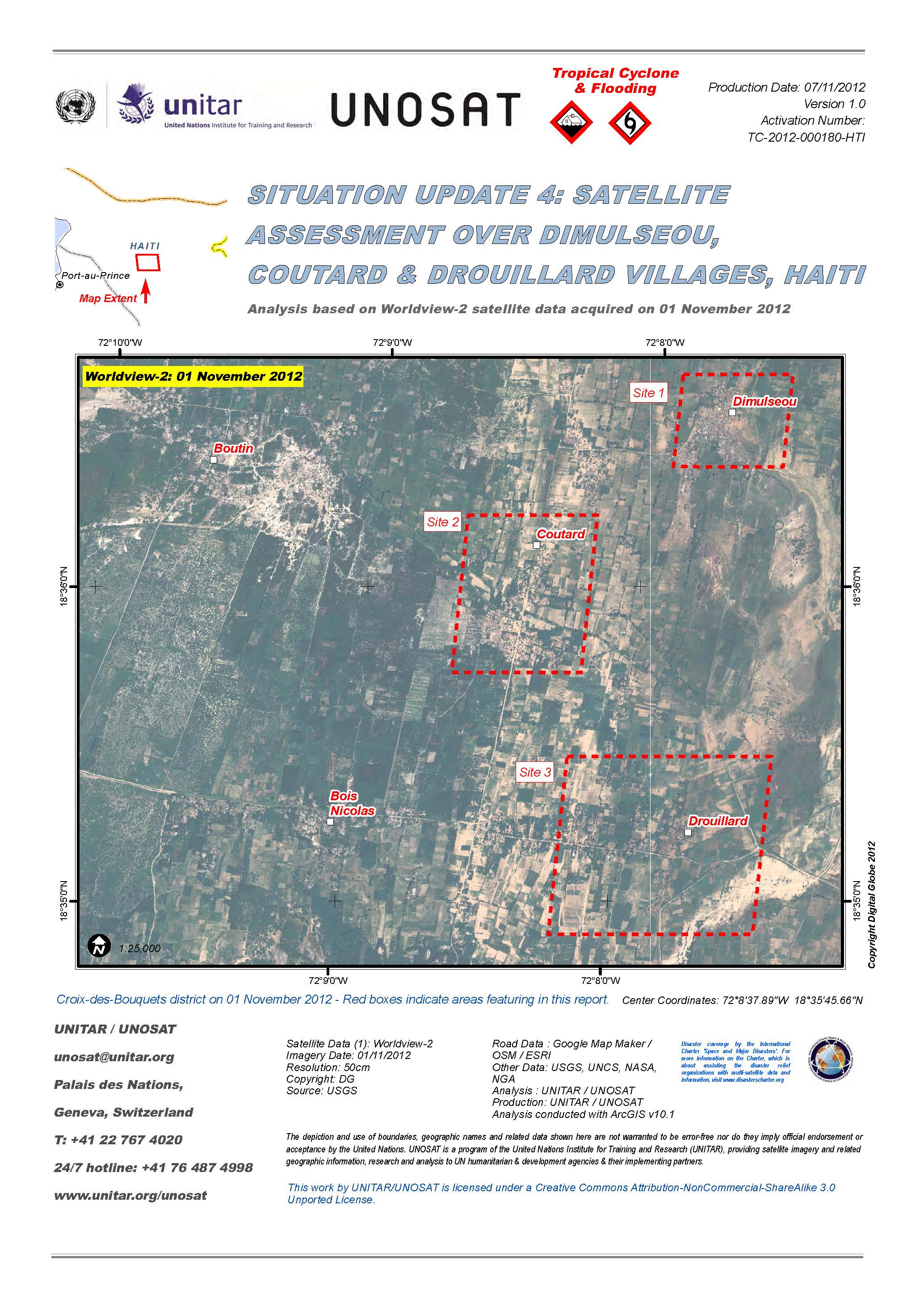
Situation update 4: Satellite assessment over Dimulseou, Coutard and Drouillard villages, Haiti.
Download Full Report
版权: DigitalGlobe
Map produced by UNITAR/UNOSAT
Information about the Product
已获得: 01/11/2012
源: WorldView-2
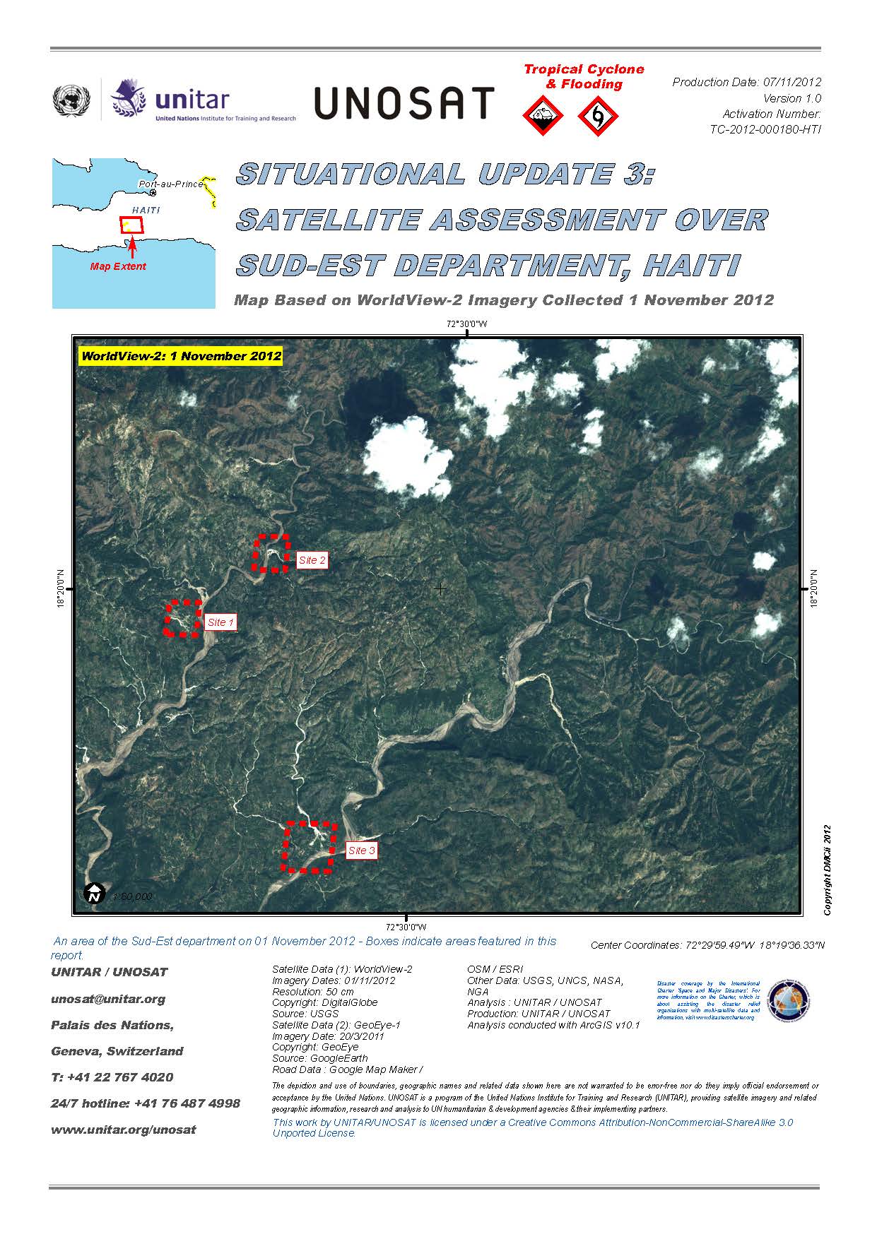
Situational update 3: Satellite assessment over South-East Department, Haiti.
Download Full Report
版权: DigitalGlobe / GeoEye
Map produced by UNITAR/UNOSAT
Information about the Product
已获得: GeoEye-1: 20/03/2011
WorldView-2: 01/11/2012
源: WorldView-2 / GeoEye-1
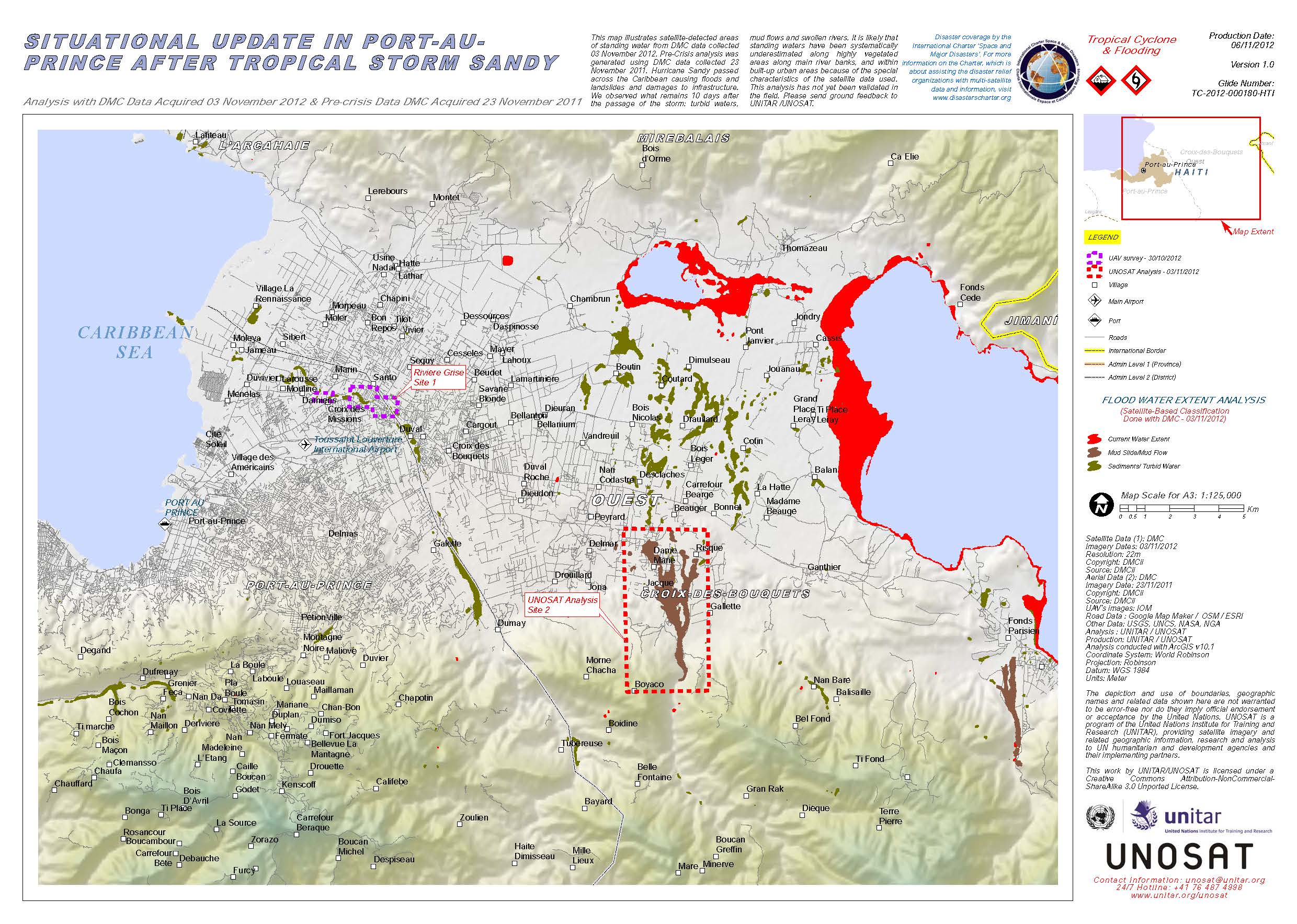
Situational update in Port-au-Prince after Tropical Storm Sandy.
Download Full Report
版权: DMCii
Map produced by UNITAR/UNOSAT
Information about the Product
已获得: Pre-crisis: 23/11/2011
Post-crisis: 03/11/2012
源: DMC
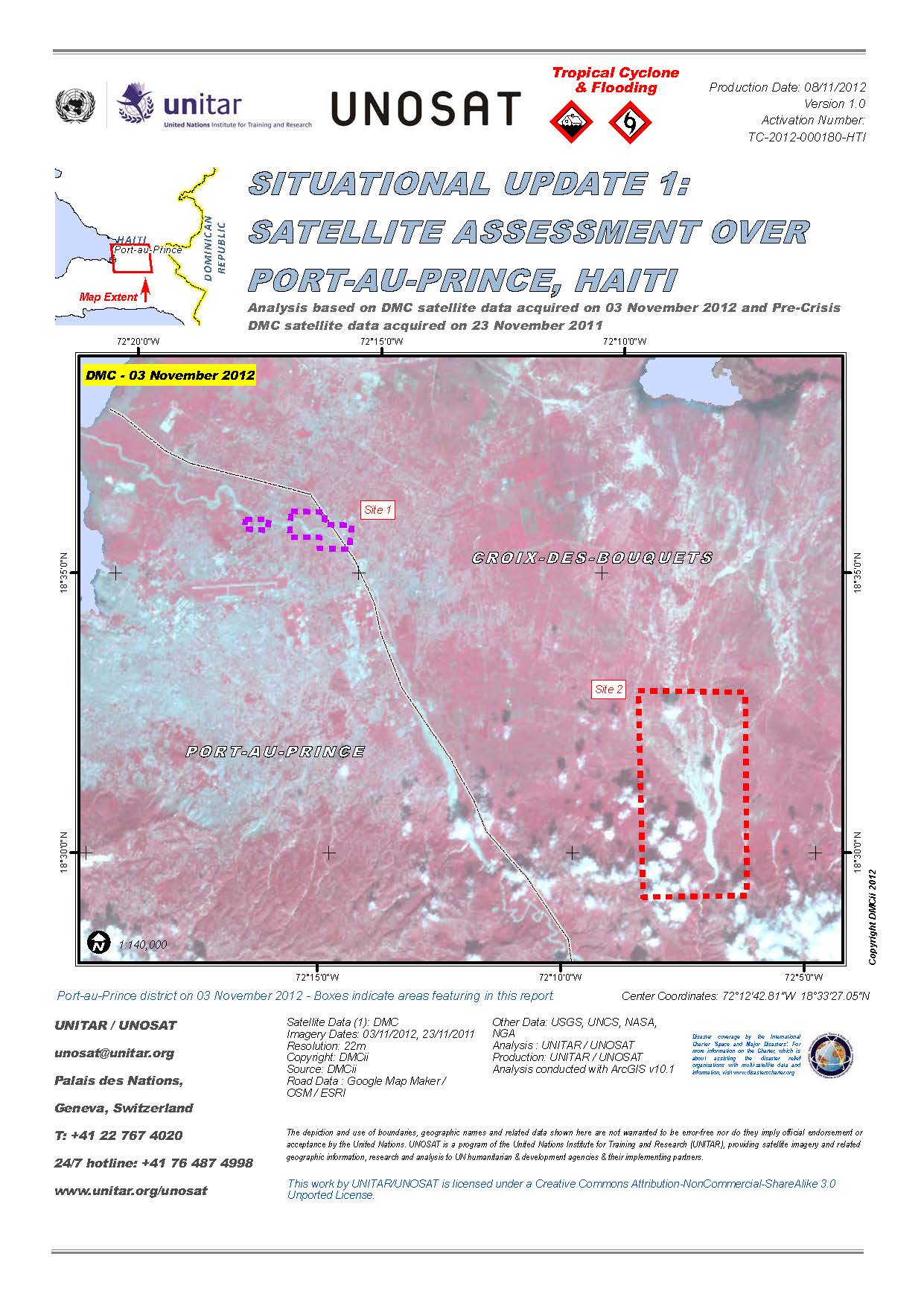
Situational update 1: Satellite assessment over Port-au-Prince, Haiti.
Download Full Report
版权: DMCii
Map produced by UNITAR/UNOSAT
Information about the Product
已获得: Pre-crisis: 23/11/2011
Post-crisis: 03/11/2012
源: DMC
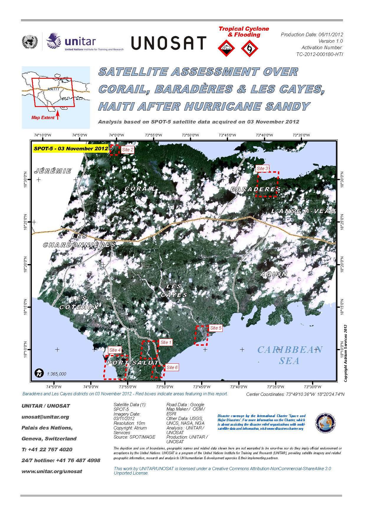
Satellite assessment over Corail, Baradères and Les Cayes, Haiti after Hurricane Sandy.
Download Full Report
版权: Astrium Services/Spot Image
Map produced by UNITAR/UNOSAT
Information about the Product
已获得: 03/11/2012
源: SPOT-5
Disaster Impact Map - Detail - Haiti - Port-au-Prince: Santo
Super-storm Sandy's impact along Grise River: affected buildings and displaced riverbanks
Scale: 1 : 2000
版权: CNES 2012 - Distribution: Astrium Services/Spot Image S.A., all rights reserved
Map produced by SERTIT
Information about the Product
已获得: Pre-crisis: 19/07/2012
Post-crisis: 02/11/2012
源: Pleaides
Disaster Impact Map - Detail - Haiti - Port-au-Prince
Grise River, riverbanks
Impacts of super-storm Sandy
Scale: 1 : 20000
版权: CNES 2012 - Distribution: Astrium Services/Spot Image S.A., all rights reserved
Map produced by SERTIT
Information about the Product
已获得: Pre-crisis: 19/07/2012
Post-crisis: 02/11/2012
源: Pleiades
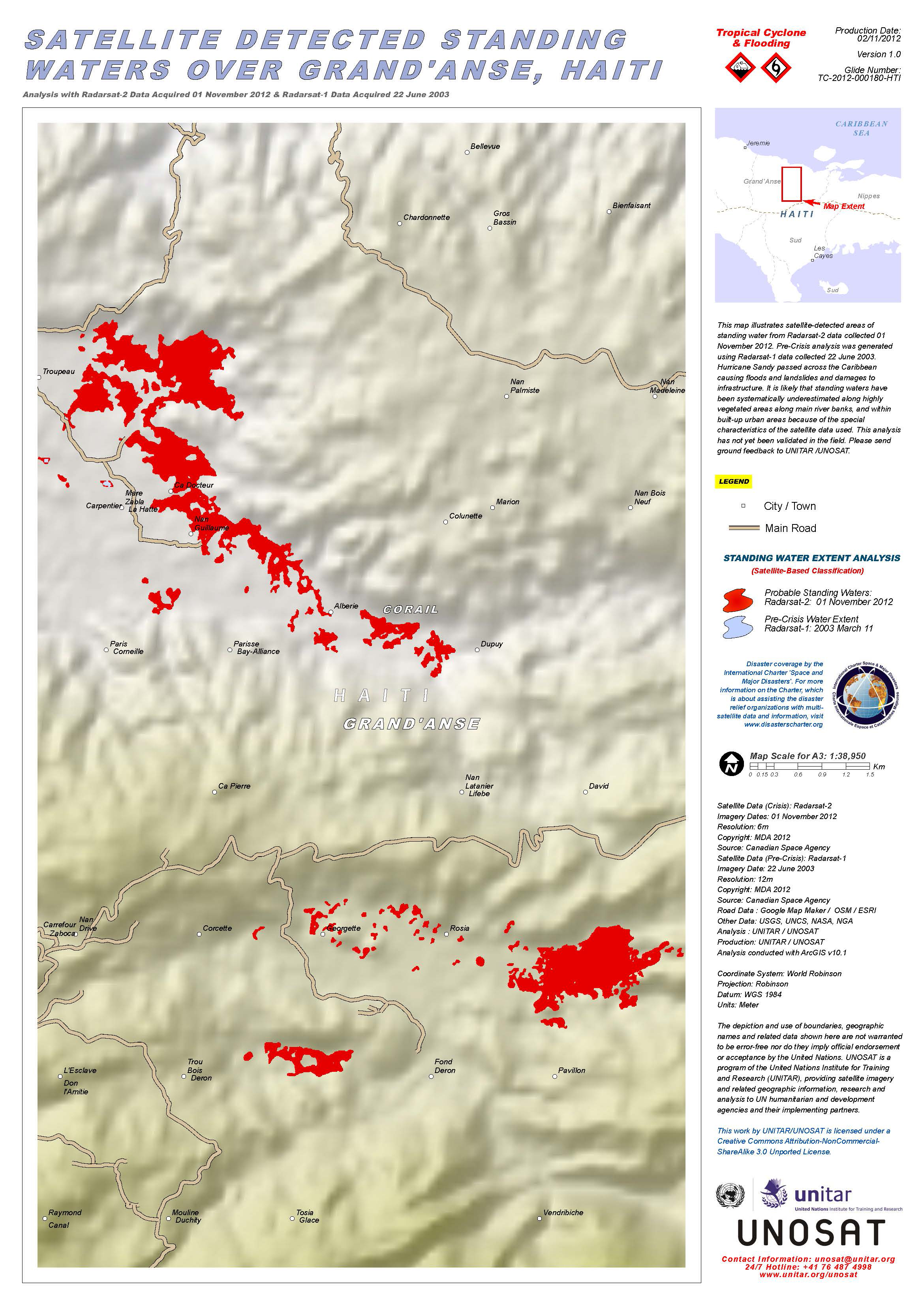
Hurricane Sandy passed across the Caribbean causing floods and landslides and damages to infrastructure. This map illustrates satellite-detected areas of standing water from RADARSAT-2 data collected 01 November 2012. Pre-Crisis analysis was generated using RADARSAT-1 data collected 22 June 2003. It is likely that standing waters have been systematically underestimated along highly vegetated areas along main river banks, and within built-up urban areas because of the special characteristics of the satellite data used. This analysis has not yet been validated in the field.
版权: RADARSAT Data and Products © MacDonald, Dettwiler and Associates Ltd. (2012) - All Rights Reserved. RADARSAT is an official trademark of the Canadian Space Agency.
Map produced by UNITAR/UNOSAT
Information about the Product
已获得: RADARSAT-1: 22/06/2003 and 11/03/2003
RADARSAT-2: 01/11/2012
源: RADARSAT-1 / RADARSAT-2
 返回完整的响应档案

