 English
 Spanish
 French
 Chinese
 Russian
 Portuguese
 Latest Activation
Charter activations
Hurricane Sandy in Haiti
Hurricane Sandy tore through the Caribbean between 26-28 October, leaving a reported 51 dead in Haiti and another 15 missing. The country's housing and terrain are particularly vulnerable to flooding, and the refugee camps from the 2010 earthquake have also been affected by the storm.
The southern part of Haiti was most affected by the storm, which includes the capital of Port-au-Prince and the 370,000 earthquake refugees in simple wood and tin shelters.
More than 200,000 people have been left homeless following the storm, with some coastal houses swept out to sea. In the aftermath of the storm, 17,200 people have been placed in shelters.
Though the flood water from the rivers were beginning to recede on Sunday, according to reports, roads have been cut off, bridges have collapsed, and crops have been destroyed, providing further difficulties to Haiti's recovery. There are also concerns that cases of Cholera may increase in the affected areas following the flooding.
-
View the SERTIT Rapid Mapping webpage for this event
| Tipo de evento: | Ocean Storm - Hurricane |
| Local do evento: | Haiti |
| Data da Ativação da Carta: | 29 October 2012 |
| Requisitante da Carta: | UNITAR/UNOSAT on behalf of UNOCHA |
| Gerenciamento de projeto: | SERTIT |
Products

Disaster Impact Map - Detail
Vaudreuil/Jameau - Port-au-Prince, Haiti
Super-storm Sandy's impact along Grise River: affected buildings and displaced riverbanks
Scale: 1 : 1500
Direitos autorais: CNES 2012 - Distribution: Astrium Services/Spot Image S.A., all rights reserved
Map produced by SERTIT
Information about the Product
Adquirida: Pre-crisis: 19/07/2012
Post-crisis: 02/11/2012
Fonte: Pleiades
Disaster Impact Map - Detail
Santo - Port-au-Prince, Haiti
Super-storm Sandy's impact along Grise River: affected buildings and displaced riverbanks
Scale: 1 : 1000
Direitos autorais: CNES 2012 - Distribution: Astrium Services/Spot Image S.A., all rights reserved
Map produced by SERTIT
Information about the Product
Adquirida: Pre-crisis: 19/07/2012
Post-crisis: 02/11/2012
Fonte: Pleaides
Disaster Impact Map - Detail
Croix des Missions - Port-au-Prince, Haiti
Super-storm Sandy's impact along Grise River: affected buildings and displaced riverbanks
Scale: 1 : 1000
Direitos autorais: CNES 2012 - Distribution: Astrium Services/Spot Image S.A., all rights reserved
Map produced by SERTIT
Information about the Product
Adquirida: Pre-crisis: 19/07/2012
Post-crisis: 02/11/2012
Fonte: Pleiades
Disaster Impact Map - Detail
Bassan/Carrefour Fougy - Port-au-Prince, Haiti
Super-storm Sandy's impact along Grise River: affected buildings and displaced riverbanks
Scale: 1 : 2000
Direitos autorais: CNES 2012 - Distribution: Astrium Services/Spot Image S.A., all rights reserved
Map produced by SERTIT
Information about the Product
Adquirida: Pre-crisis: 19/07/2012
Post-crisis: 02/11/2012
Fonte: Pleiades
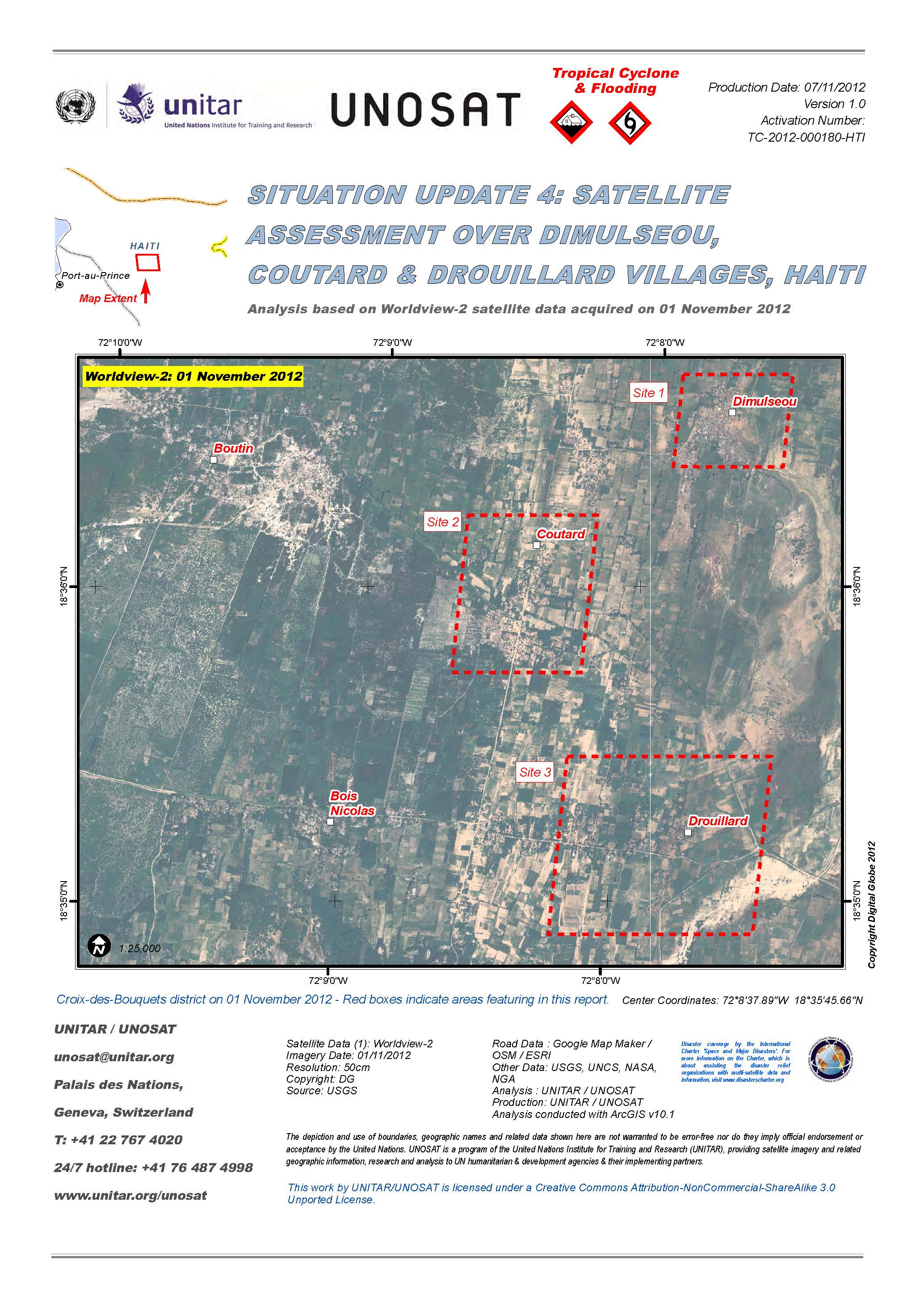
Situation update 4: Satellite assessment over Dimulseou, Coutard and Drouillard villages, Haiti.
Download Full Report
Direitos autorais: DigitalGlobe
Map produced by UNITAR/UNOSAT
Information about the Product
Adquirida: 01/11/2012
Fonte: WorldView-2
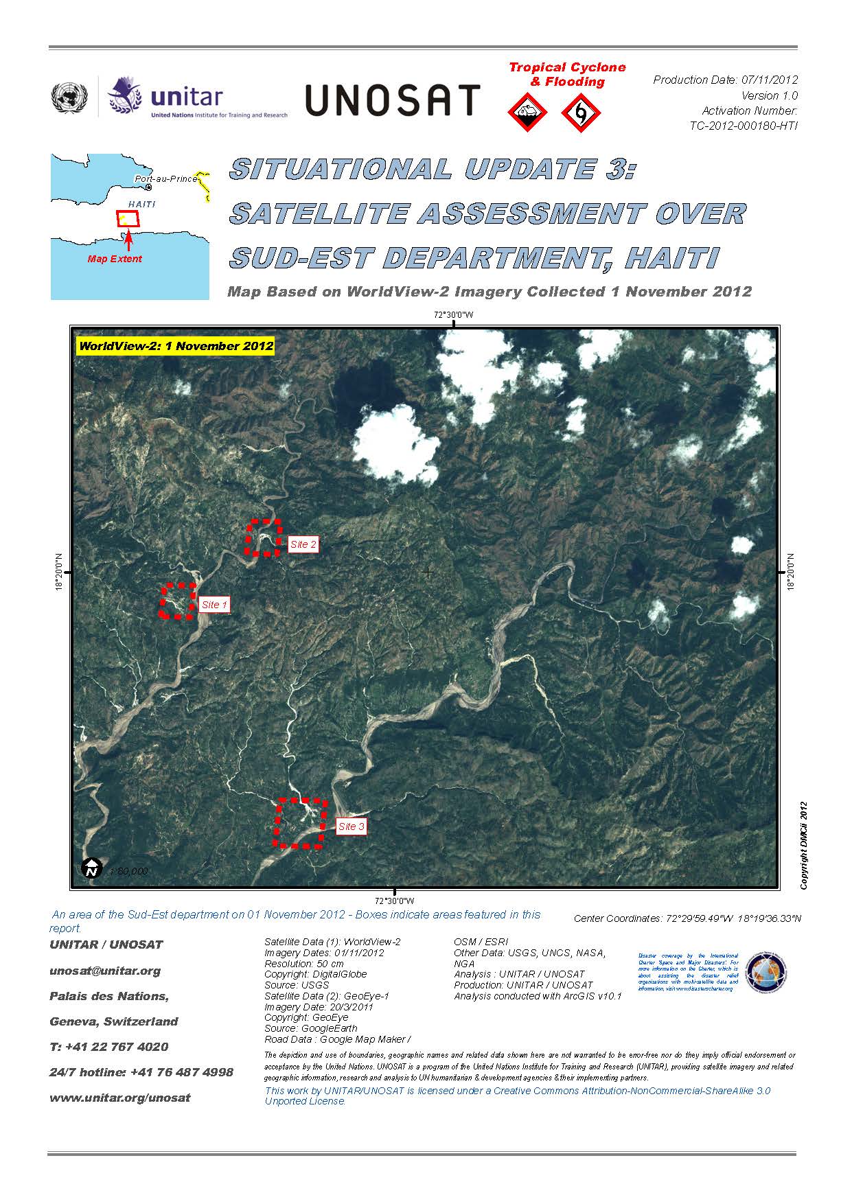
Situational update 3: Satellite assessment over South-East Department, Haiti.
Download Full Report
Direitos autorais: DigitalGlobe / GeoEye
Map produced by UNITAR/UNOSAT
Information about the Product
Adquirida: GeoEye-1: 20/03/2011
WorldView-2: 01/11/2012
Fonte: WorldView-2 / GeoEye-1
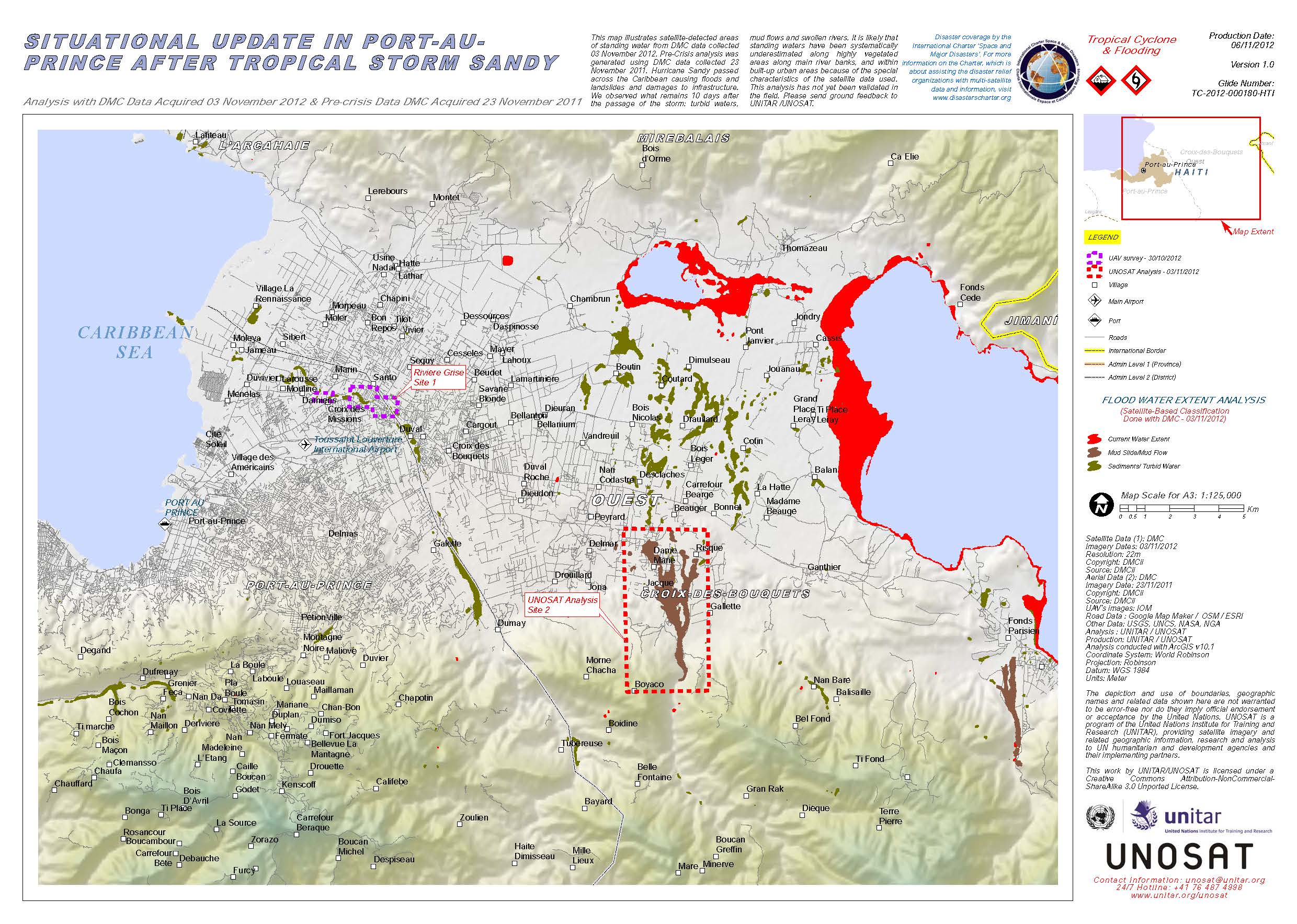
Situational update in Port-au-Prince after Tropical Storm Sandy.
Download Full Report
Direitos autorais: DMCii
Map produced by UNITAR/UNOSAT
Information about the Product
Adquirida: Pre-crisis: 23/11/2011
Post-crisis: 03/11/2012
Fonte: DMC
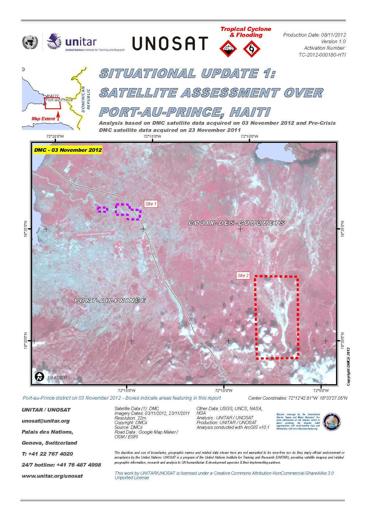
Situational update 1: Satellite assessment over Port-au-Prince, Haiti.
Download Full Report
Direitos autorais: DMCii
Map produced by UNITAR/UNOSAT
Information about the Product
Adquirida: Pre-crisis: 23/11/2011
Post-crisis: 03/11/2012
Fonte: DMC
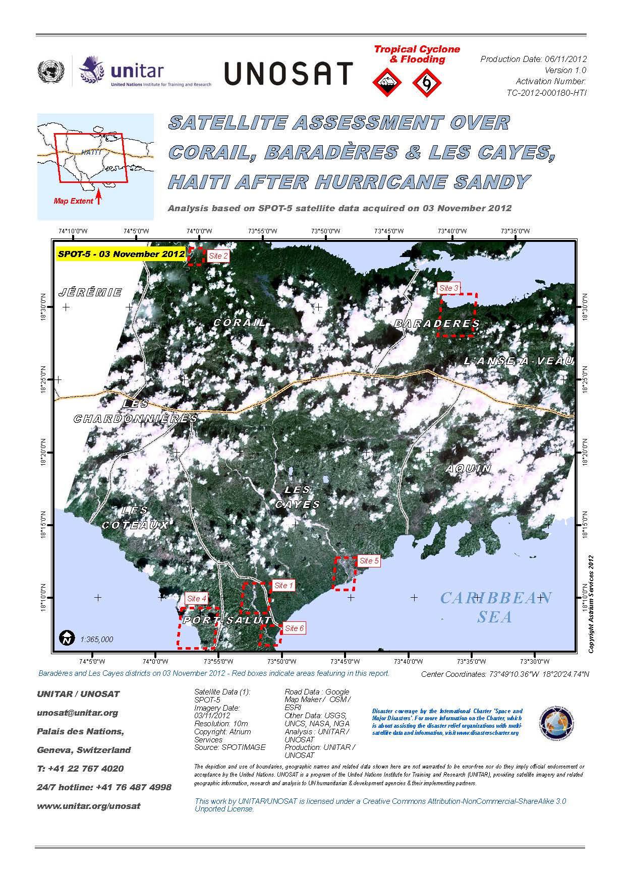
Satellite assessment over Corail, Baradères and Les Cayes, Haiti after Hurricane Sandy.
Download Full Report
Direitos autorais: Astrium Services/Spot Image
Map produced by UNITAR/UNOSAT
Information about the Product
Adquirida: 03/11/2012
Fonte: SPOT-5
Disaster Impact Map - Detail - Haiti - Port-au-Prince: Santo
Super-storm Sandy's impact along Grise River: affected buildings and displaced riverbanks
Scale: 1 : 2000
Direitos autorais: CNES 2012 - Distribution: Astrium Services/Spot Image S.A., all rights reserved
Map produced by SERTIT
Information about the Product
Adquirida: Pre-crisis: 19/07/2012
Post-crisis: 02/11/2012
Fonte: Pleaides
Disaster Impact Map - Detail - Haiti - Port-au-Prince
Grise River, riverbanks
Impacts of super-storm Sandy
Scale: 1 : 20000
Direitos autorais: CNES 2012 - Distribution: Astrium Services/Spot Image S.A., all rights reserved
Map produced by SERTIT
Information about the Product
Adquirida: Pre-crisis: 19/07/2012
Post-crisis: 02/11/2012
Fonte: Pleiades
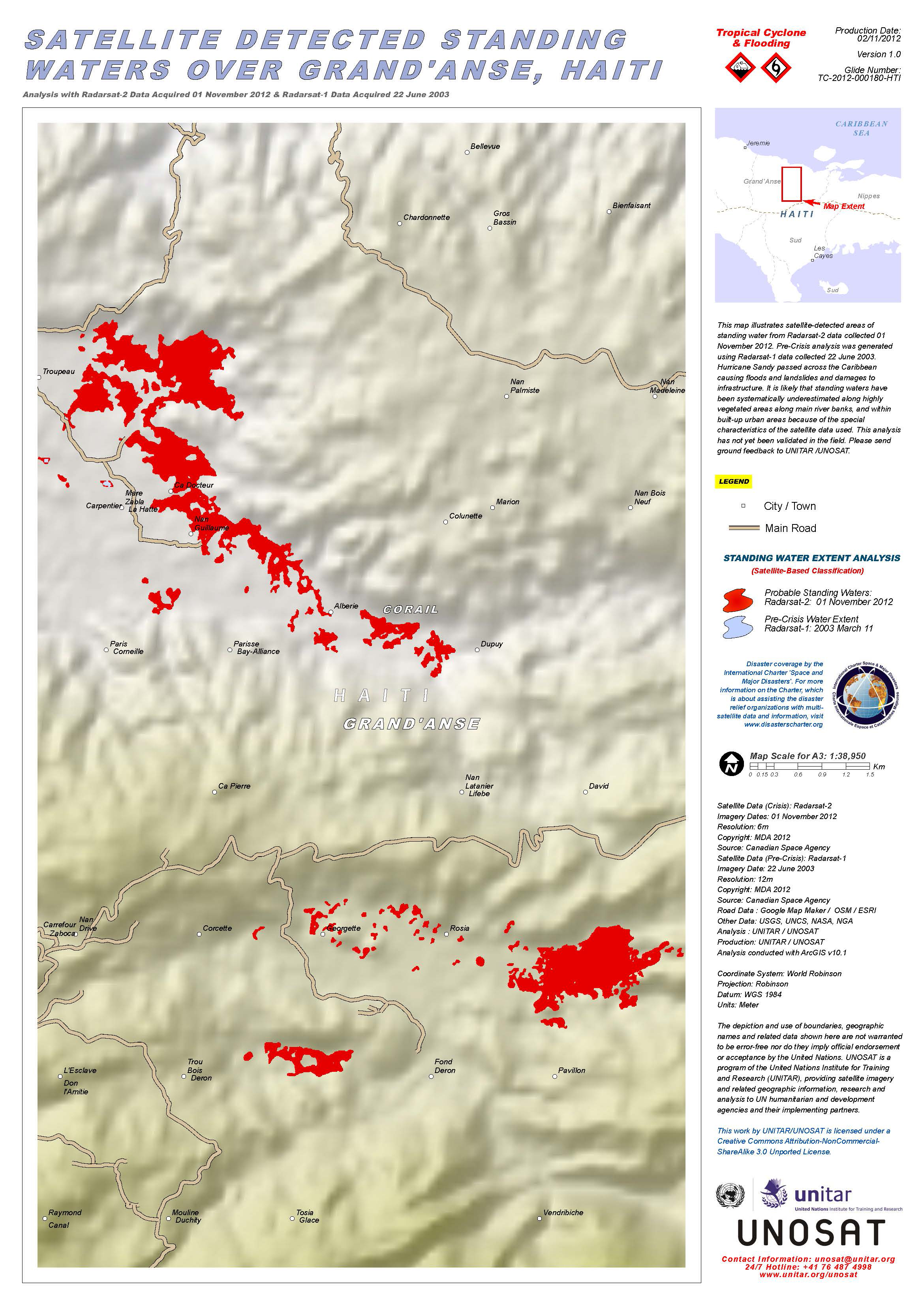
Hurricane Sandy passed across the Caribbean causing floods and landslides and damages to infrastructure. This map illustrates satellite-detected areas of standing water from RADARSAT-2 data collected 01 November 2012. Pre-Crisis analysis was generated using RADARSAT-1 data collected 22 June 2003. It is likely that standing waters have been systematically underestimated along highly vegetated areas along main river banks, and within built-up urban areas because of the special characteristics of the satellite data used. This analysis has not yet been validated in the field.
Direitos autorais: RADARSAT Data and Products © MacDonald, Dettwiler and Associates Ltd. (2012) - All Rights Reserved. RADARSAT is an official trademark of the Canadian Space Agency.
Map produced by UNITAR/UNOSAT
Information about the Product
Adquirida: RADARSAT-1: 22/06/2003 and 11/03/2003
RADARSAT-2: 01/11/2012
Fonte: RADARSAT-1 / RADARSAT-2
 Voltar ao arquivo completo da Ativação

