 English
 Spanish
 French
 Chinese
 Russian
 Portuguese
 最新宪章启动
Charter activations
苏丹洪水
苏丹18个州的13个地区的暴雨造成了洪灾,受灾最为严重的地区是卡萨拉省和森纳尔省。房屋和基础设施已遭到破坏,政府估计有8万人受到影响,并有76人丧生。
此次强降雨已经摧毁了3000多所房屋,并在卡萨拉省东部省份又冲毁了3000多所房屋。据报道,尼罗河水位已经处于100多年来的最高水平。
官方表示,遭受洪水侵袭而流离失所的人们现在正面临着粮食短缺和疾病威胁。许多人为了安全而逃到山上,但现在没有食物或医疗用品供应。
救助工作正在进行,以提供食品、清洁水和药品。
| 事件类型: | 洪水 |
| 事件地点: | 苏丹 |
| 启动宪章的日期: | 2016年8月9日 |
| 宪章启动时间: | 18:38:00 |
| 宪章启动时区: | UTC+02:00 |
| 宪章要求者: | UNITAR(联合国调查训练研究所)- UNOSAT(联合国卫星应用计划训练与研究营运中心)代表联合国人道事务协调厅(UNOCHA) |
| 项目经理: | UNITAR(联合国调查训练研究所)/ UNOSAT(联合国卫星应用计划训练与研究营运中心) |
Products
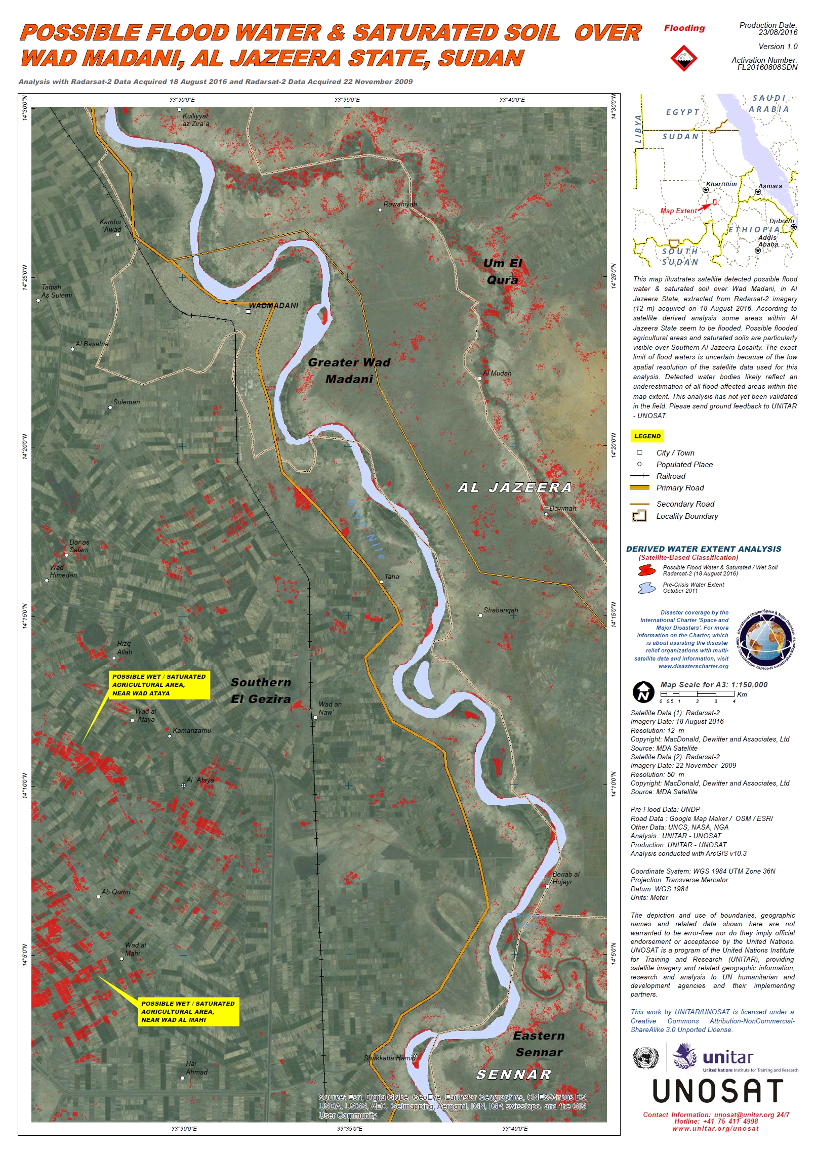
Possible flood water and saturated soil over Wad Madani, Al Jazeera State, Sudan
版权: RADARSAT-2 Data and Products © MacDonald, Dettwiler and Associates Ltd. (2016) - All Rights Reserved. RADARSAT is an official trademark of the Canadian Space Agency.
Map produced by UNITAR/UNOSAT
Information about the Product
已获得: Pre-disaster: 22/11/2009
Post-disaster: 18/08/2016
源: RADARSAT-2
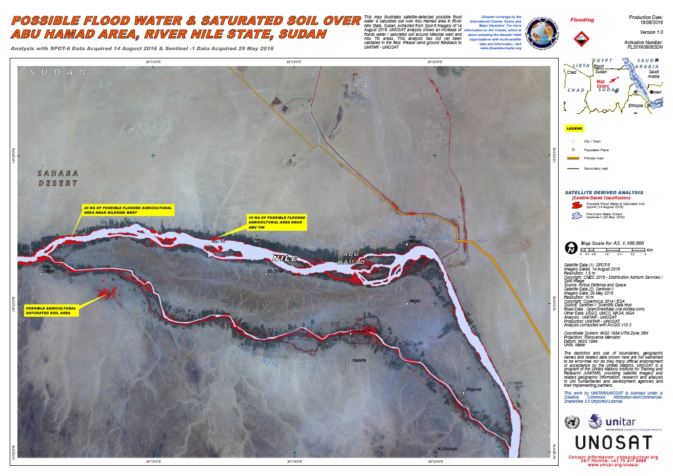
Possible flood water and saturated soil over Abu Hamad Area, River Nile State, Sudan
版权: SPOT-6 © CNES 2016 - Distribution: Airbus Defence and Space, all rights reserved
Sentinel-1: Copernicus Sentinel data 2015 / ESA
Map produced by UNITAR/UNOSAT
Information about the Product
已获得: SPOT-6: 14/08/2016
Sentinel-1: 29/05/2015
源: SPOT-6 / Sentinel-1
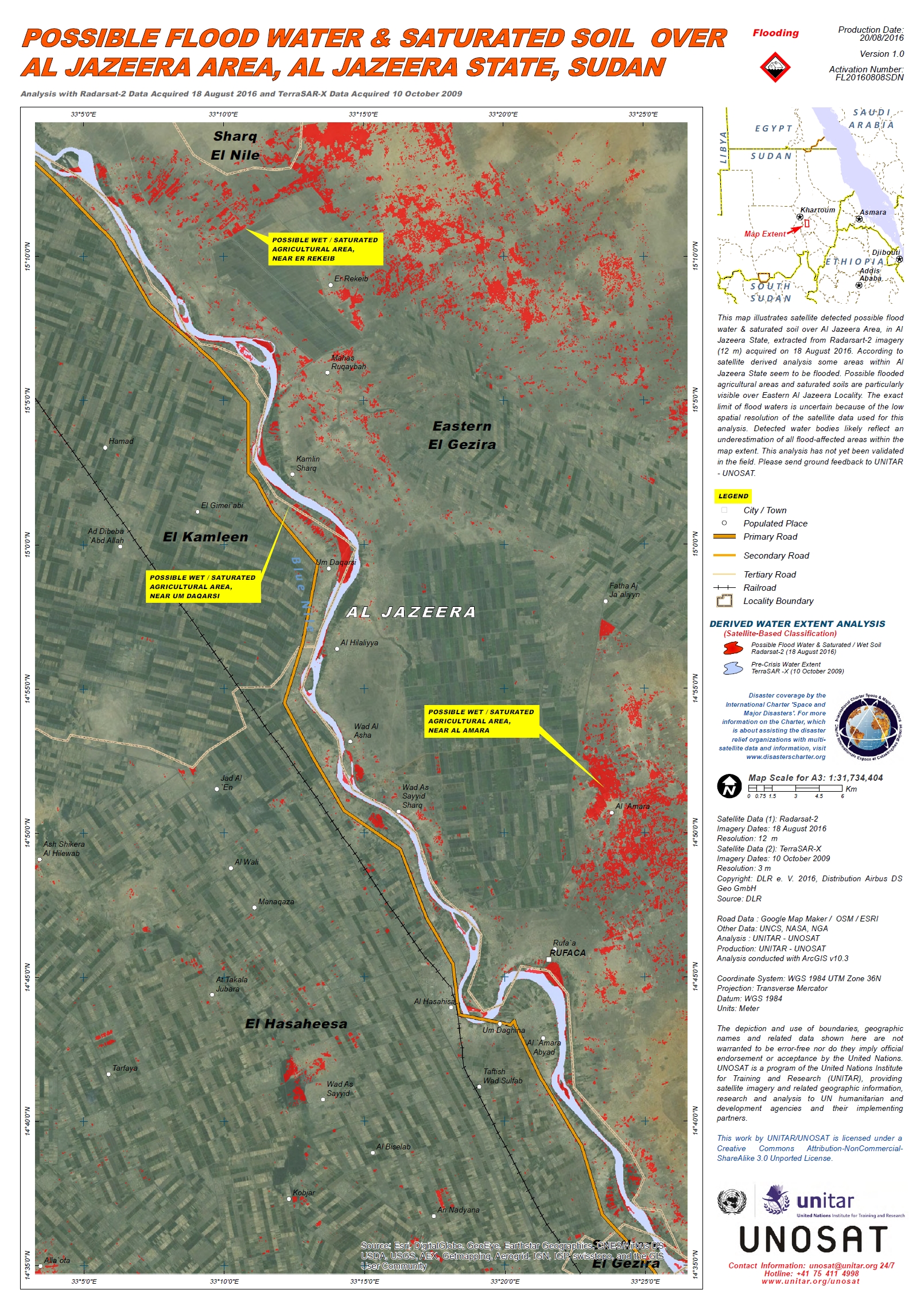
Possible flood water and saturated soil over Al Jazeera Area, Al Jazeera State, Sudan
版权: TerraSAR-X © DLR e. V. 2016, Distribution: Airbus DS Geo GmbH
RADARSAT-2 Data and Products © MacDonald, Dettwiler and Associates Ltd. (2016) - All Rights Reserved. RADARSAT is an official trademark of the Canadian Space Agency.
Map produced by UNITAR/UNOSAT
Information about the Product
已获得: TerraSAR-X: 10/10/2009
RADARSAT-2: 18/08/2016
源: TerraSAR-X / RADARSAT-2
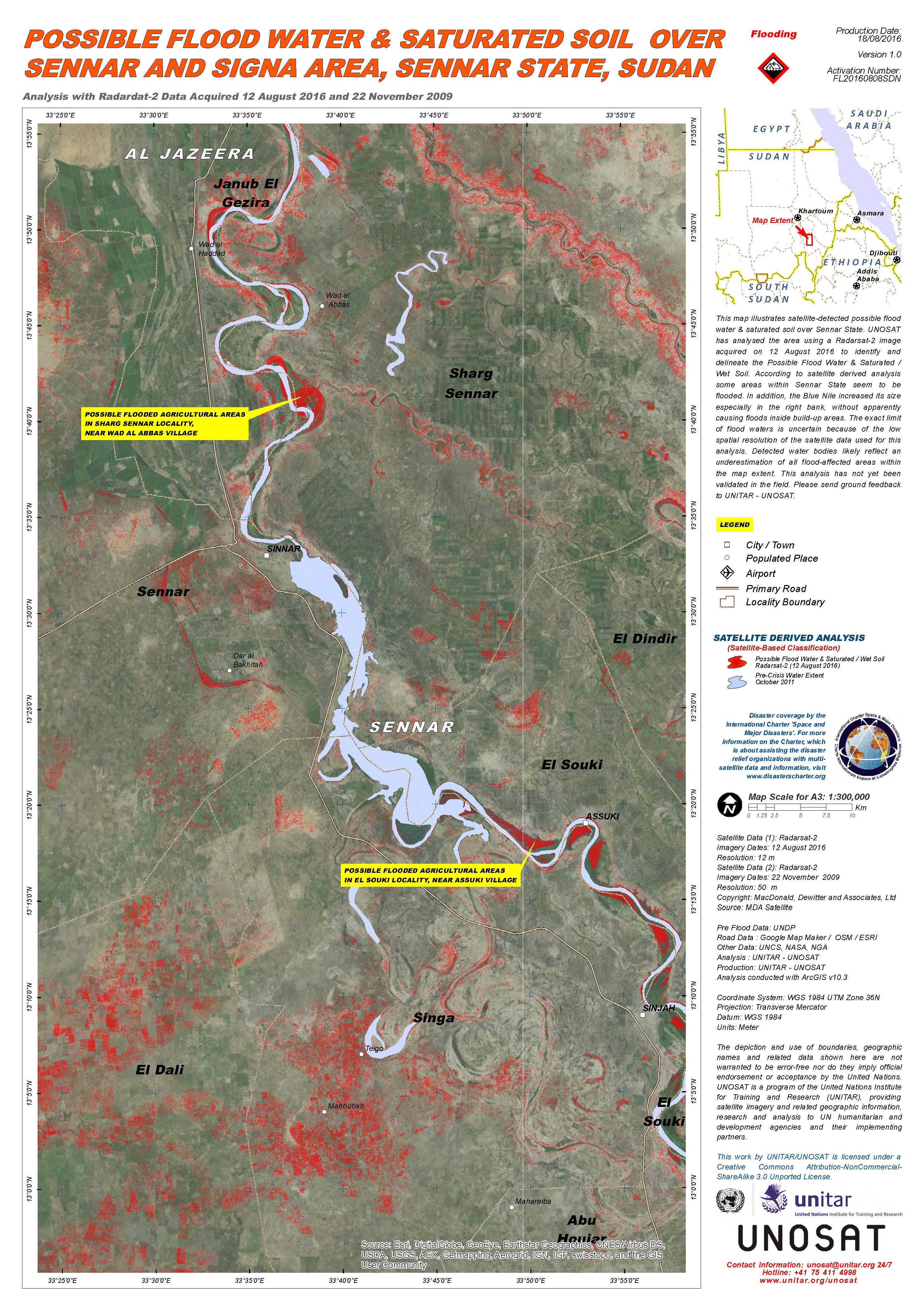
Possible flood water and saturated soil over Sennar and Signa area, Sennar state, Sudan
版权: RADARSAT-2 Data and Products © MacDonald, Dettwiler and Associates Ltd. (2016) - All Rights Reserved. RADARSAT is an official trademark of the Canadian Space Agency.
Map produced by UNITAR/UNOSAT
Information about the Product
已获得: Pre-disaster: 22/11/2009
Post-disaster: 12/08/2016
源: RADARSAT-2
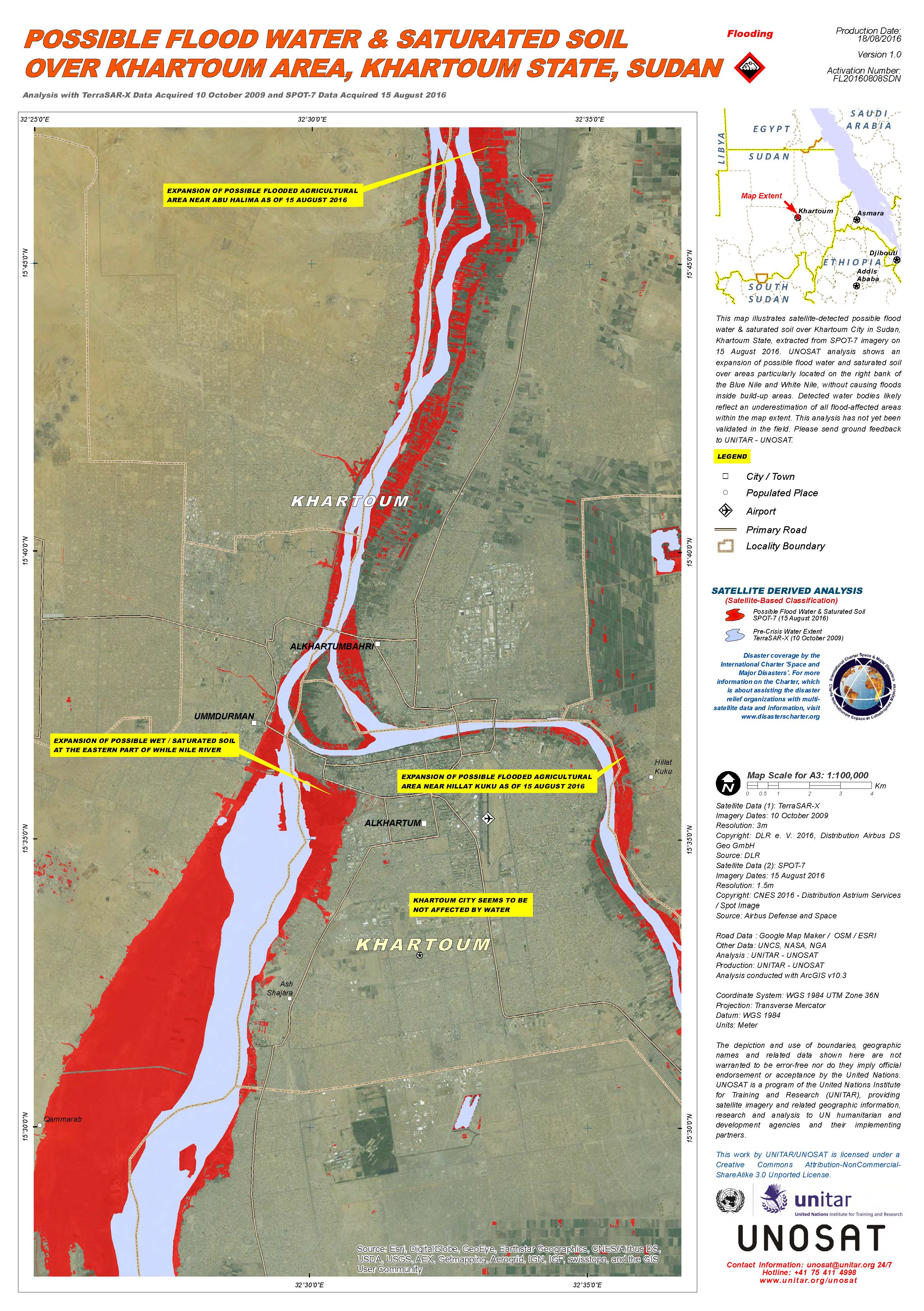
Possible flood water and saturated soil over Khartoum area, Khartoum state, Sudan
版权: TerraSAR-X © DLR e. V. 2016, Distribution: Airbus DS Geo GmbH
SPOT-7 © Airbus Defence and Space 2016, all rights reserved
Map produced by UNITAR/UNOSAT
Information about the Product
已获得: TerraSAR-X: 10/10/2009
SPOT-7: 15/08/2016
源: TerraSAR-X / SPOT-7
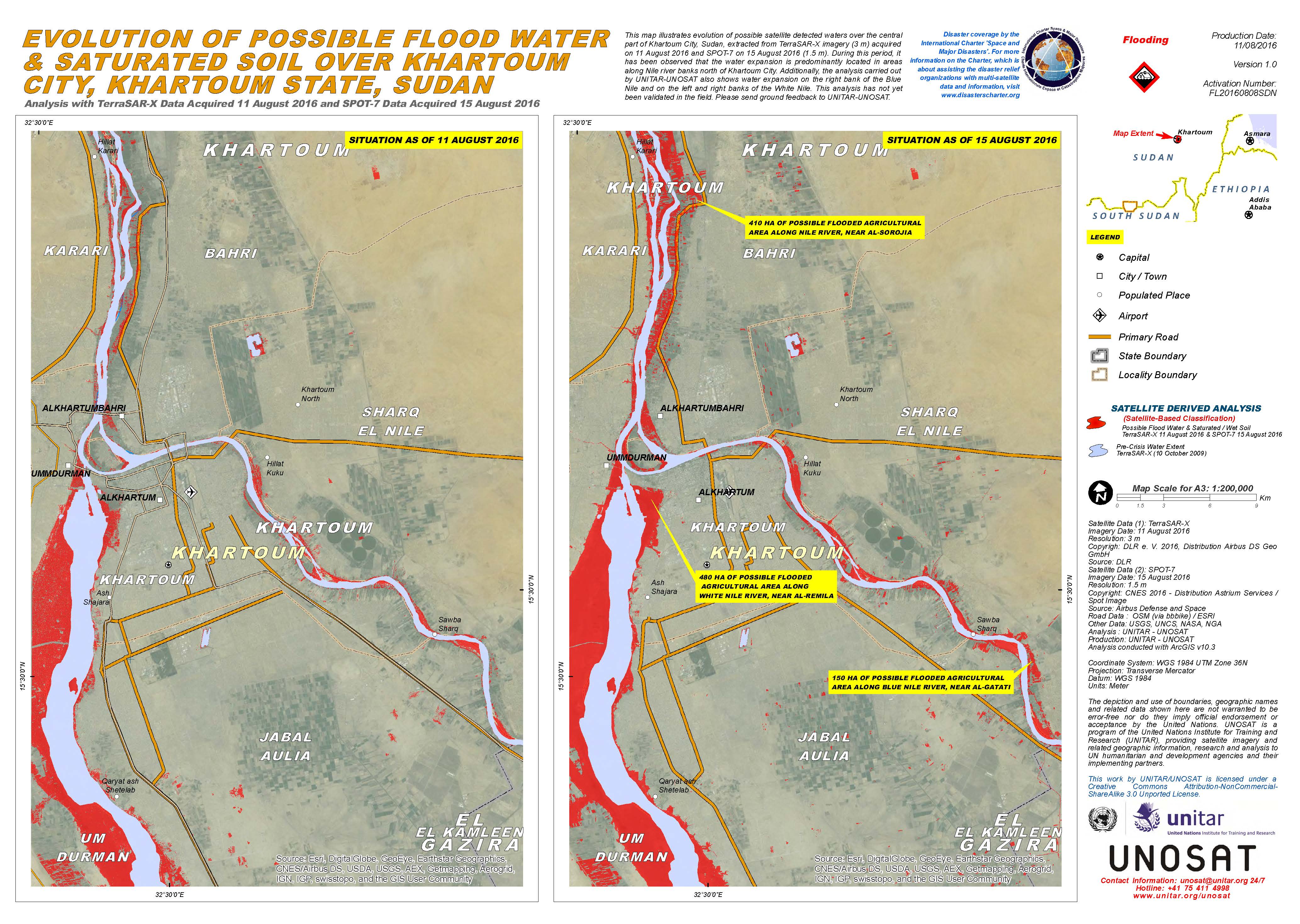
Evolution of possible flood water and saturated soil over Khartoum city, Khartoum state, Sudan
版权: TerraSAR-X © DLR e. V. 2016, Distribution: Airbus DS Geo GmbH
SPOT-7 © Airbus Defence and Space 2016, all rights reserved
Map produced by UNITAR/UNOSAT
Information about the Product
已获得: TerraSAR-X: 11/08/2016
SPOT-7: 15/08/2016
源: TerraSAR-X / SPOT-7
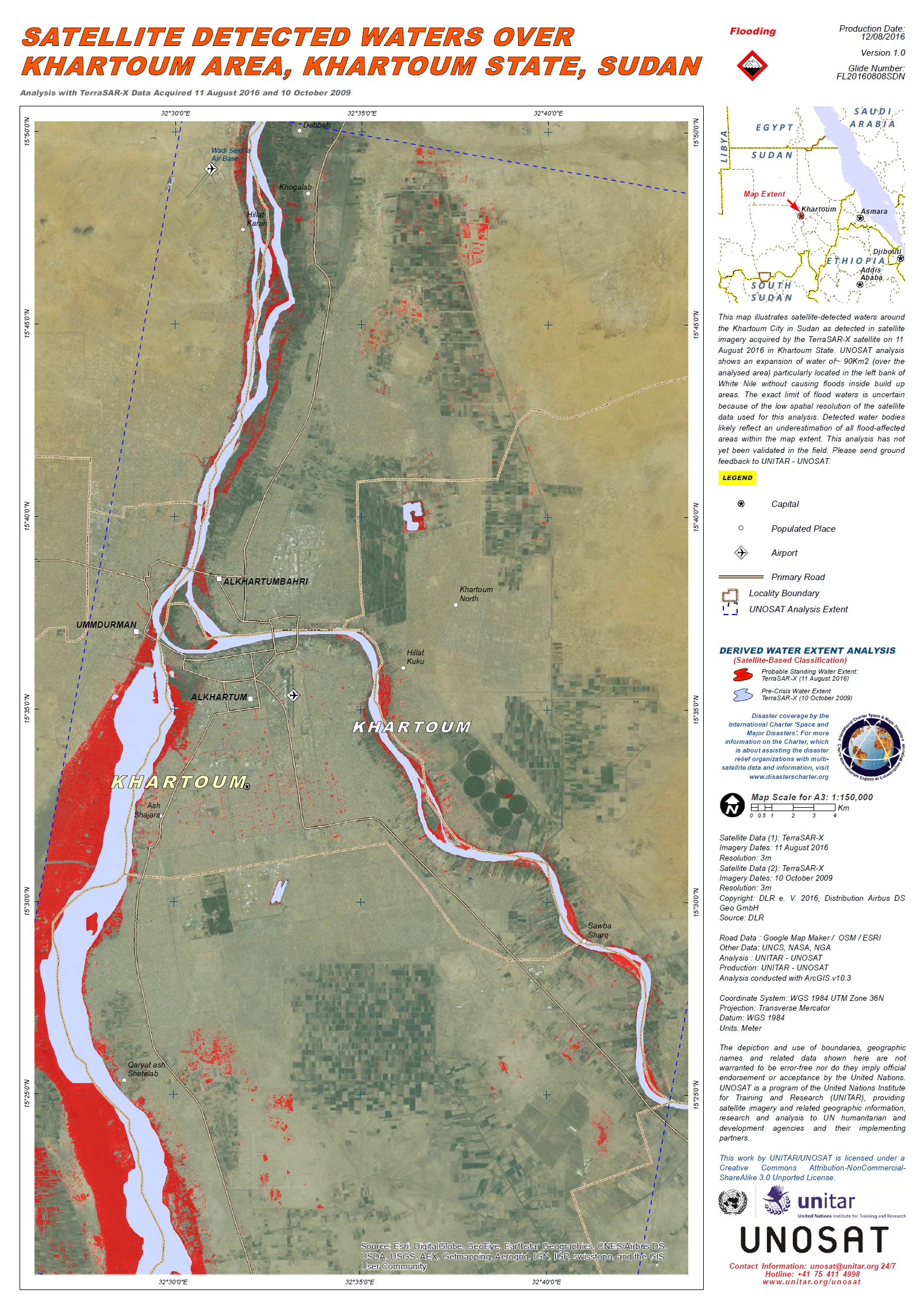
Flood waters over Khartoum Area, Khartoum State, Sudan
版权: DLR e. V. 2016, Distribution: Airbus DS Geo GmbH
Map produced by UNITAR/UNOSAT
Information about the Product
已获得: Pre-disaster: 10/10/2009
Post-disaster: 11/08/2016
源: TerraSAR-X
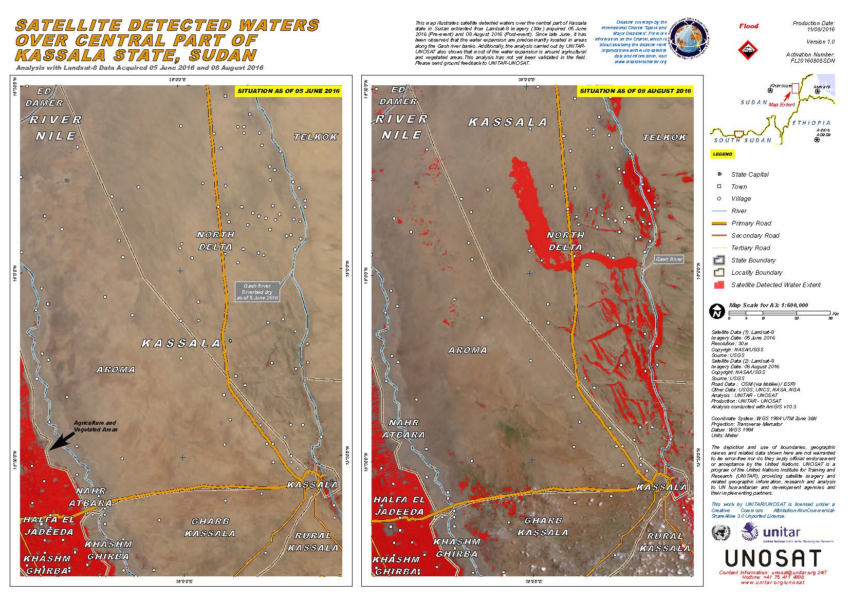
Flood waters over central part of Kassala State, Sudan
版权: USGS (2016) - All rights reserved
Map produced by UNITAR/UNOSAT
Information about the Product
已获得: Pre-disaster: 05/06/2016
Post-disaster: 08/08/2016
源: Landsat 8
 返回完整的响应档案

