 English
 Spanish
 French
 Chinese
 Russian
 Portuguese
 Последняя Активация
Charter activations
Flood in Sudan
Heavy rainfall has caused flash floods in 13 of 18 states across Sudan, particularly affected areas were Kassala and Sennar States. Houses and infrastructure have been damaged and the government estimates that 80,000 people have been affected and 76 people have been killed.
The heavy rainfall has destroyed over 3000 homes and damaged another 3000 in the eastern province of Kassala. The Nile River is reported to be at its highest level in over 100 years.
Officials said people displaced by the floods are now facing food shortages and threats from disease. Many have fled to the mountains for safety but now have no food or medical supplies.
Relief efforts are underway to provide food, clean water and medicines.
| Тип события: | Floods |
| Место события: | Sudan |
| Date of Charter Activation: | 9 August 2016 |
| Время активации Хартии: | 18:38:00 |
| TЧасовой пояс в районе активации Хартии: | UTC+02:00 |
| Запрос на активацию поступил от: | UNITAR UNOSAT on behalf of UNOCHA |
| Менеждер проекта от: | UNITAR/UNOSAT |
Products
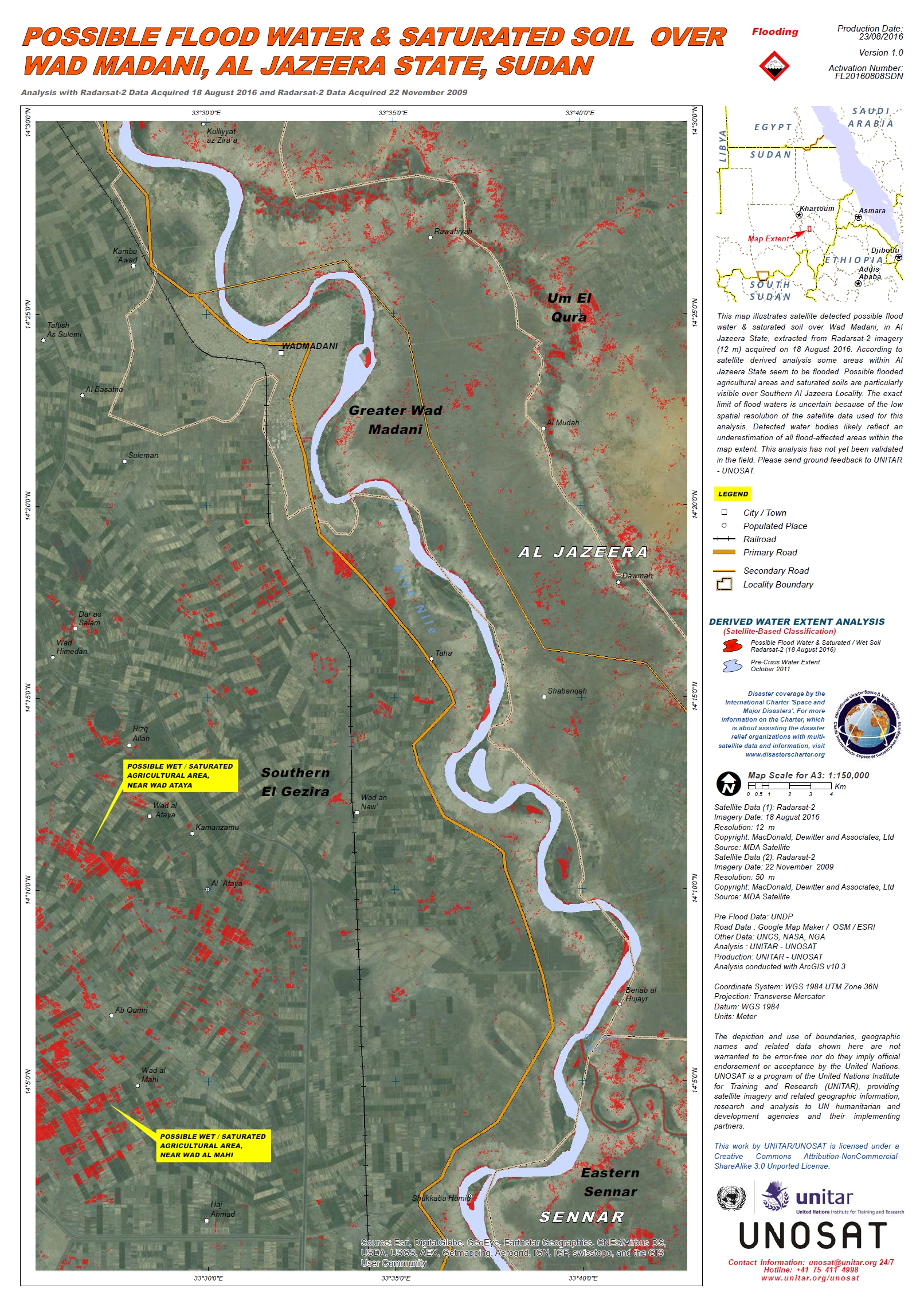
Possible flood water and saturated soil over Wad Madani, Al Jazeera State, Sudan
Авторские права: RADARSAT-2 Data and Products © MacDonald, Dettwiler and Associates Ltd. (2016) - All Rights Reserved. RADARSAT is an official trademark of the Canadian Space Agency.
Map produced by UNITAR/UNOSAT
Information about the Product
Получено: Pre-disaster: 22/11/2009
Post-disaster: 18/08/2016
Источник: RADARSAT-2
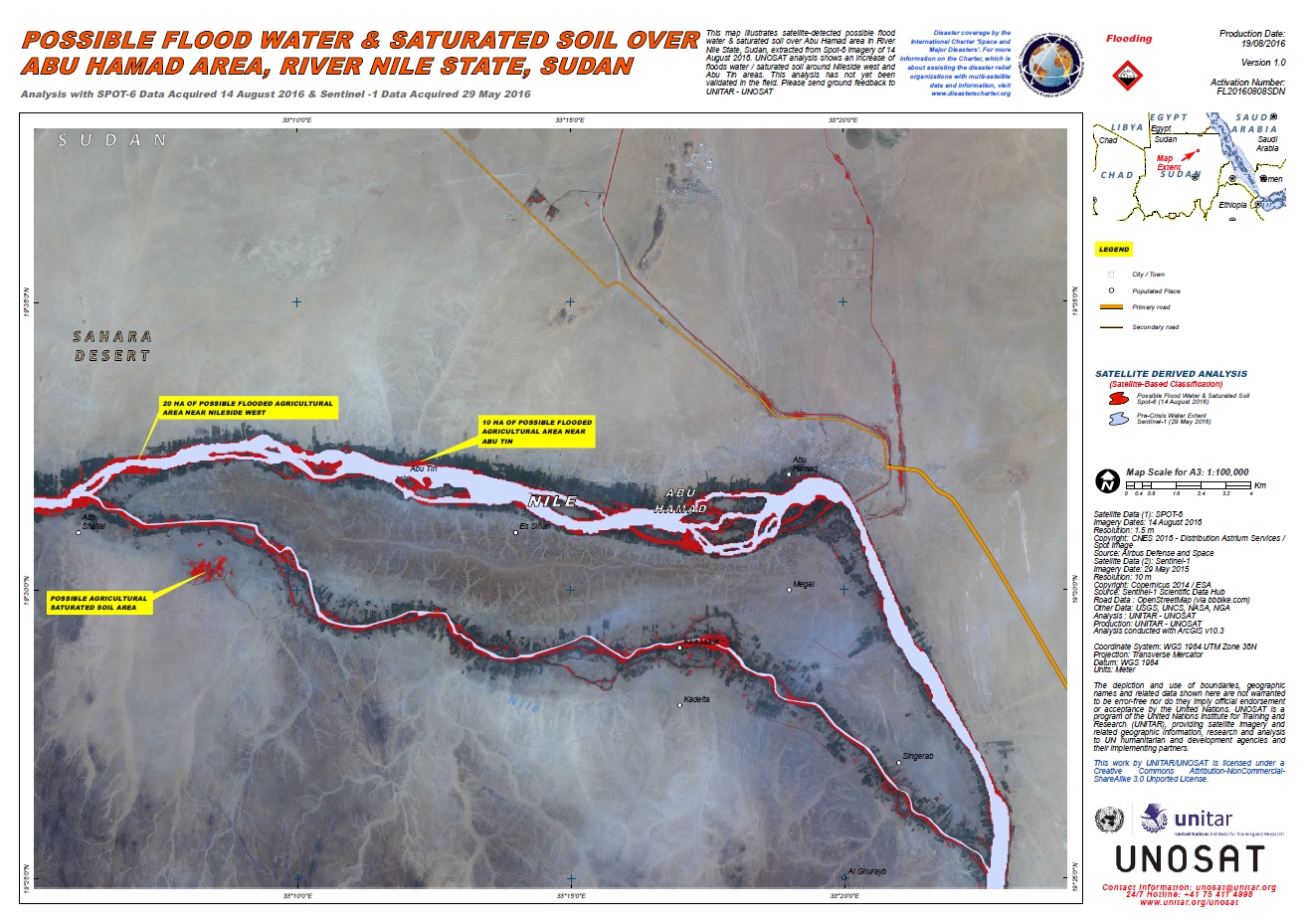
Possible flood water and saturated soil over Abu Hamad Area, River Nile State, Sudan
Авторские права: SPOT-6 © CNES 2016 - Distribution: Airbus Defence and Space, all rights reserved
Sentinel-1: Copernicus Sentinel data 2015 / ESA
Map produced by UNITAR/UNOSAT
Information about the Product
Получено: SPOT-6: 14/08/2016
Sentinel-1: 29/05/2015
Источник: SPOT-6 / Sentinel-1
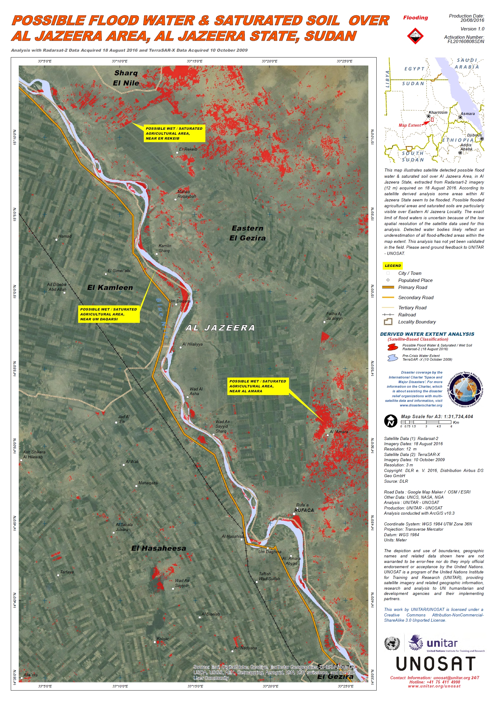
Possible flood water and saturated soil over Al Jazeera Area, Al Jazeera State, Sudan
Авторские права: TerraSAR-X © DLR e. V. 2016, Distribution: Airbus DS Geo GmbH
RADARSAT-2 Data and Products © MacDonald, Dettwiler and Associates Ltd. (2016) - All Rights Reserved. RADARSAT is an official trademark of the Canadian Space Agency.
Map produced by UNITAR/UNOSAT
Information about the Product
Получено: TerraSAR-X: 10/10/2009
RADARSAT-2: 18/08/2016
Источник: TerraSAR-X / RADARSAT-2
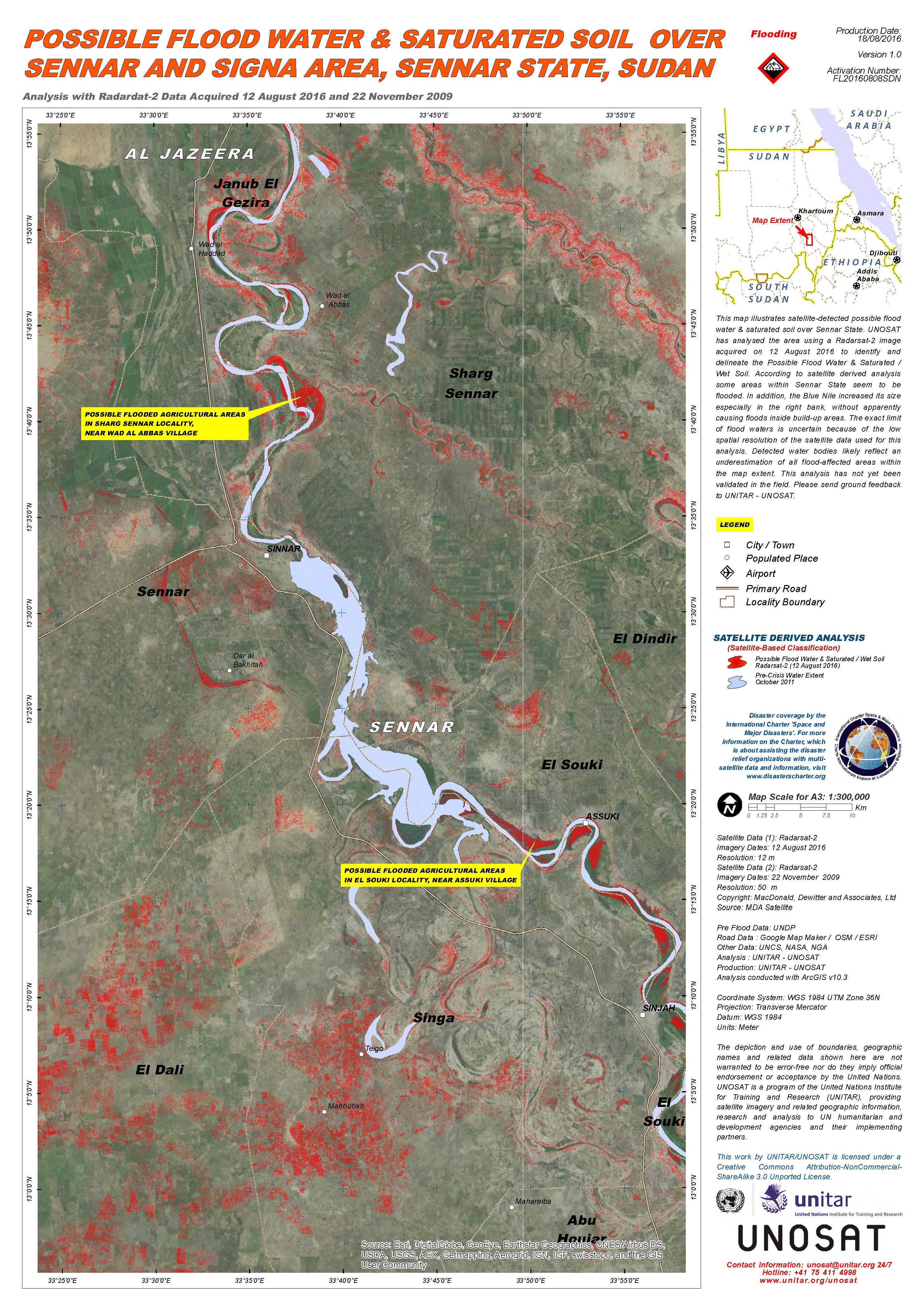
Possible flood water and saturated soil over Sennar and Signa area, Sennar state, Sudan
Авторские права: RADARSAT-2 Data and Products © MacDonald, Dettwiler and Associates Ltd. (2016) - All Rights Reserved. RADARSAT is an official trademark of the Canadian Space Agency.
Map produced by UNITAR/UNOSAT
Information about the Product
Получено: Pre-disaster: 22/11/2009
Post-disaster: 12/08/2016
Источник: RADARSAT-2
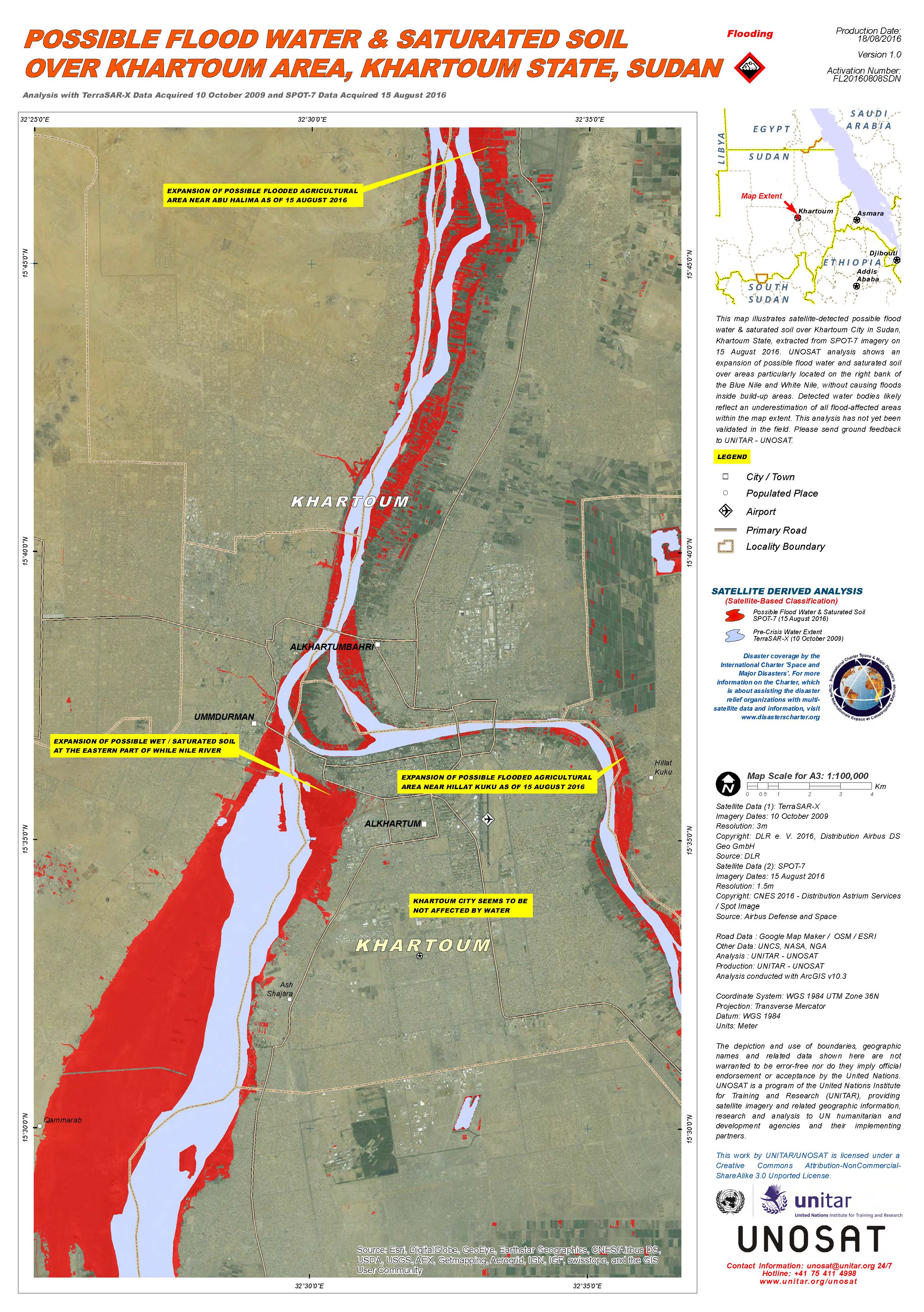
Possible flood water and saturated soil over Khartoum area, Khartoum state, Sudan
Авторские права: TerraSAR-X © DLR e. V. 2016, Distribution: Airbus DS Geo GmbH
SPOT-7 © Airbus Defence and Space 2016, all rights reserved
Map produced by UNITAR/UNOSAT
Information about the Product
Получено: TerraSAR-X: 10/10/2009
SPOT-7: 15/08/2016
Источник: TerraSAR-X / SPOT-7
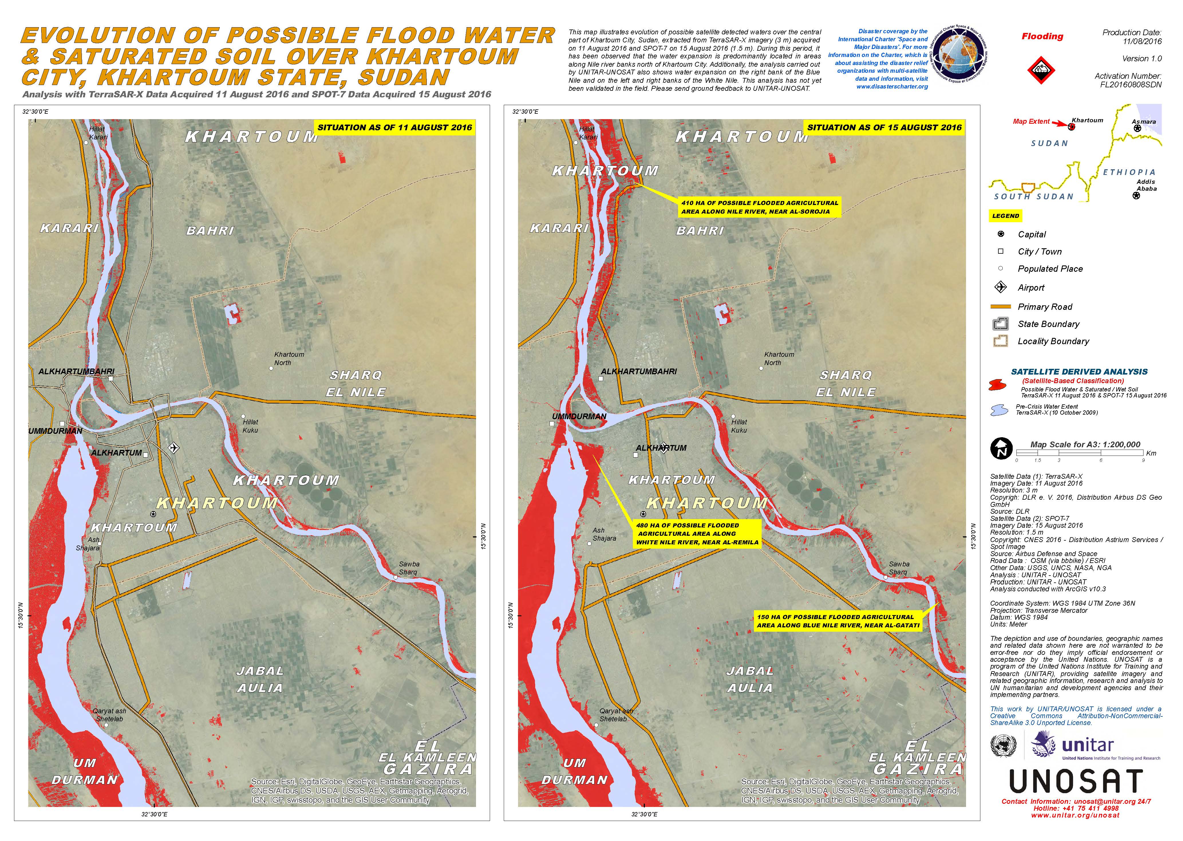
Evolution of possible flood water and saturated soil over Khartoum city, Khartoum state, Sudan
Авторские права: TerraSAR-X © DLR e. V. 2016, Distribution: Airbus DS Geo GmbH
SPOT-7 © Airbus Defence and Space 2016, all rights reserved
Map produced by UNITAR/UNOSAT
Information about the Product
Получено: TerraSAR-X: 11/08/2016
SPOT-7: 15/08/2016
Источник: TerraSAR-X / SPOT-7
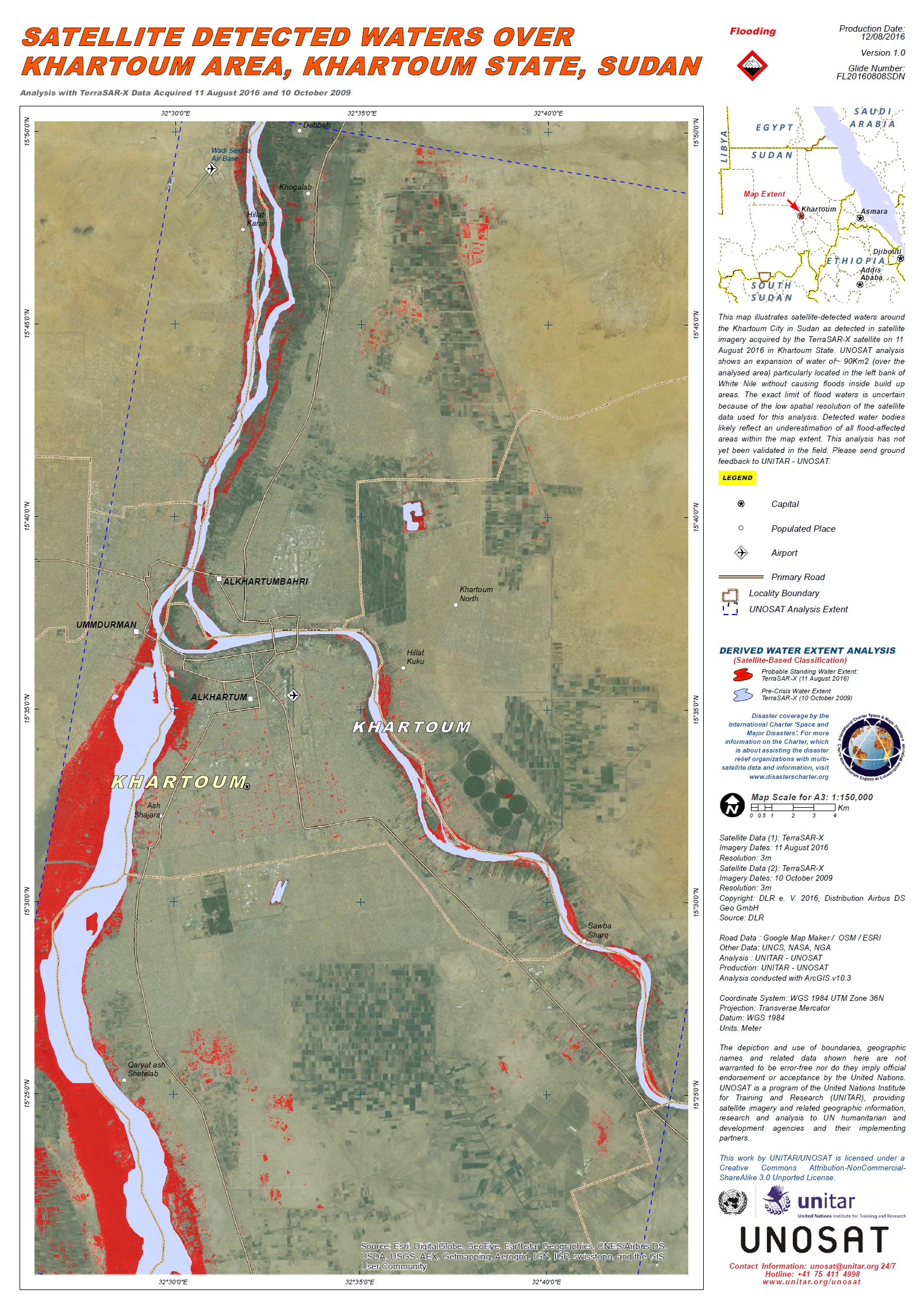
Flood waters over Khartoum Area, Khartoum State, Sudan
Авторские права: DLR e. V. 2016, Distribution: Airbus DS Geo GmbH
Map produced by UNITAR/UNOSAT
Information about the Product
Получено: Pre-disaster: 10/10/2009
Post-disaster: 11/08/2016
Источник: TerraSAR-X
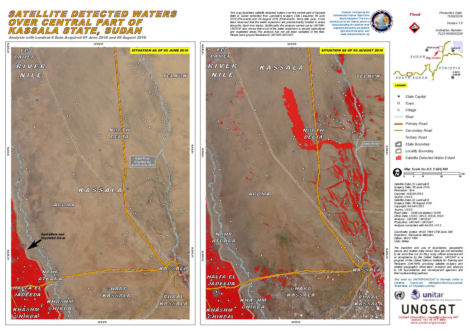
Flood waters over central part of Kassala State, Sudan
Авторские права: USGS (2016) - All rights reserved
Map produced by UNITAR/UNOSAT
Information about the Product
Получено: Pre-disaster: 05/06/2016
Post-disaster: 08/08/2016
Источник: Landsat 8
 Вернуться к полному архиву активаций

