 English
 Spanish
 French
 Chinese
 Russian
 Portuguese
 最新宪章启动
Charter activations
孟加拉国洪水
暴雨造成了孟加拉国北部和中部地区的洪水,影响了全国二十多个地区。
据报道称这次灾害没有造成人员伤亡,但洪水对成千上万的人造成了影像,数百个村庄遭到破坏。道路被洪水淹没,使人们无法通行。该地区的许多人已经被洪水隔离,救援工作正在进行中,帮助那些受到灾害影响的人们。
据报道,14条主要河流都被带到了危险的高水位。
达卡的首府城市受到洪水的影响,在城市的低洼地区,许多房屋都被淹没了。有人担心这些持续的洪水可能会导致疾病的爆发。
| 事件类型: | 洪水 |
| 事件地点: | 孟加拉国 |
| 启动宪章的日期: | 2015年9月7日 |
| 宪章启动时间: | 09:13:20 |
| 宪章启动时区: | UTC+02:00 |
| 宪章要求者: | 亚洲减灾中心代表孟加拉国空间研究与遥感组织 |
| 项目经理: | 亚洲理工学院 |
Products
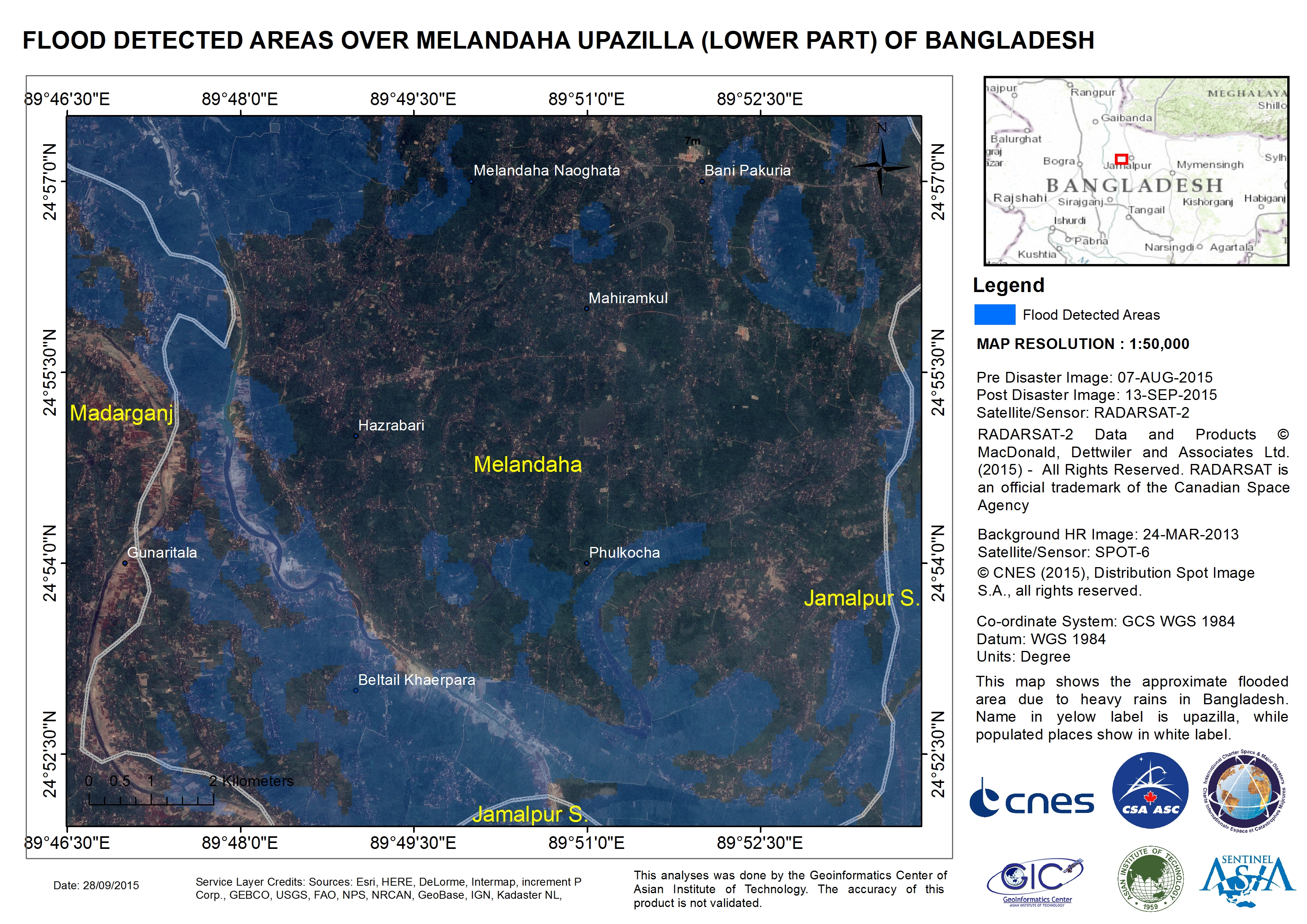
Flood detected areas over Melandaha Upazilla, in the lower part of Bangladesh
版权: RADARSAT-2 Data and Products © MacDonald, Dettwiler and Associates Ltd. (2015) - All Rights Reserved. RADARSAT is an official trademark of the Canadian Space Agency.
SPOT-6 © CNES 2015 - Distribution: Airbus Defence and Space, all rights reserved
Map produced by Geoinformatics Center, Asian Institute of Technology
Information about the Product
已获得: RADARSAT-2: 07/08/2015 and 13/09/2015
SPOT-6: 24/03/2013
源: RADARSAT-2 / SPOT-6
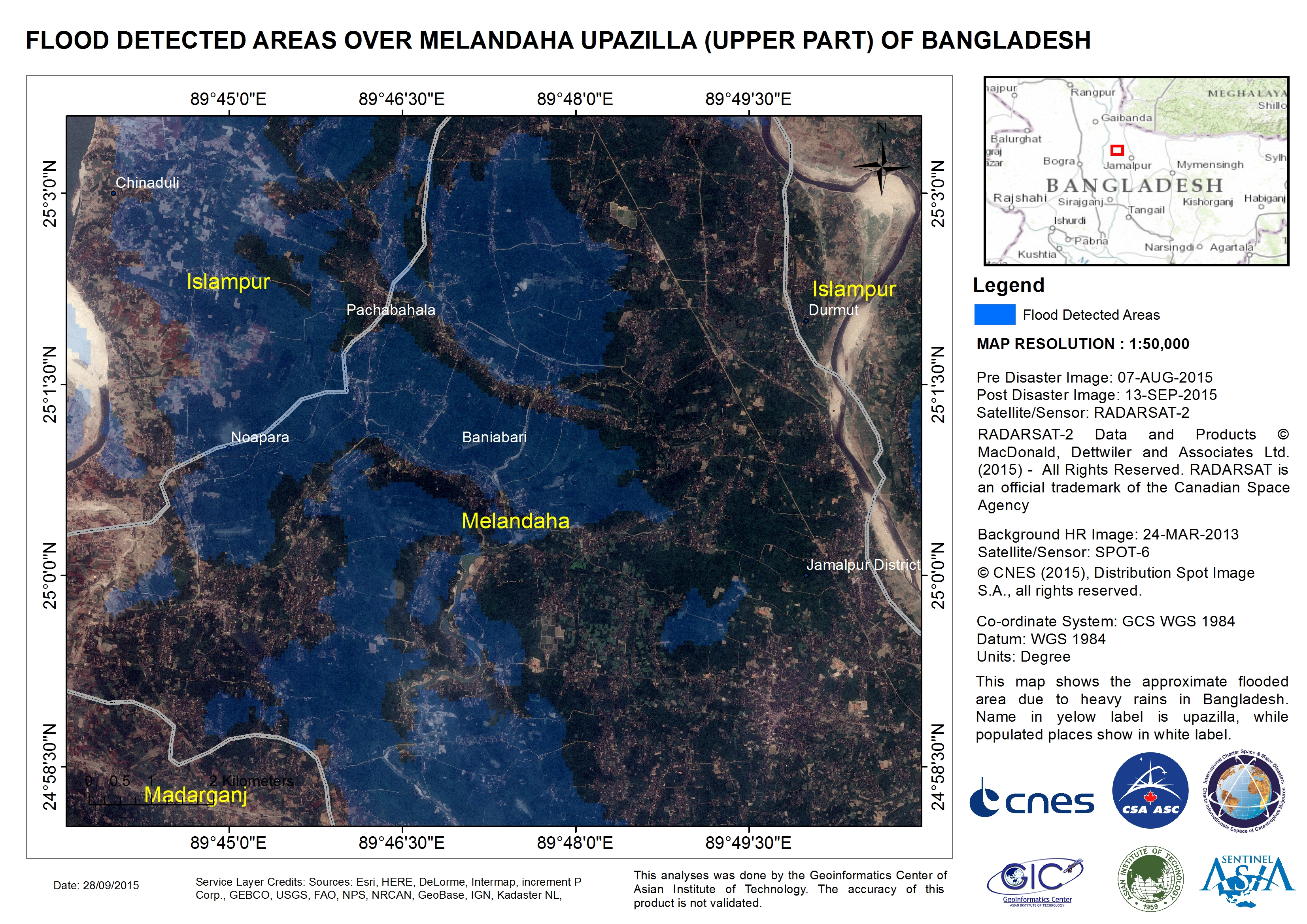
Flood detected areas over Melandaha Upazilla, in the upper part of Bangladesh
版权: RADARSAT-2 Data and Products © MacDonald, Dettwiler and Associates Ltd. (2015) - All Rights Reserved. RADARSAT is an official trademark of the Canadian Space Agency.
SPOT-6 © CNES 2015 - Distribution: Airbus Defence and Space, all rights reserved
Map produced by Geoinformatics Center, Asian Institute of Technology
Information about the Product
已获得: RADARSAT-2: 07/08/2015 and 13/09/2015
SPOT-6: 24/03/2013
源: RADARSAT-2 / SPOT-6
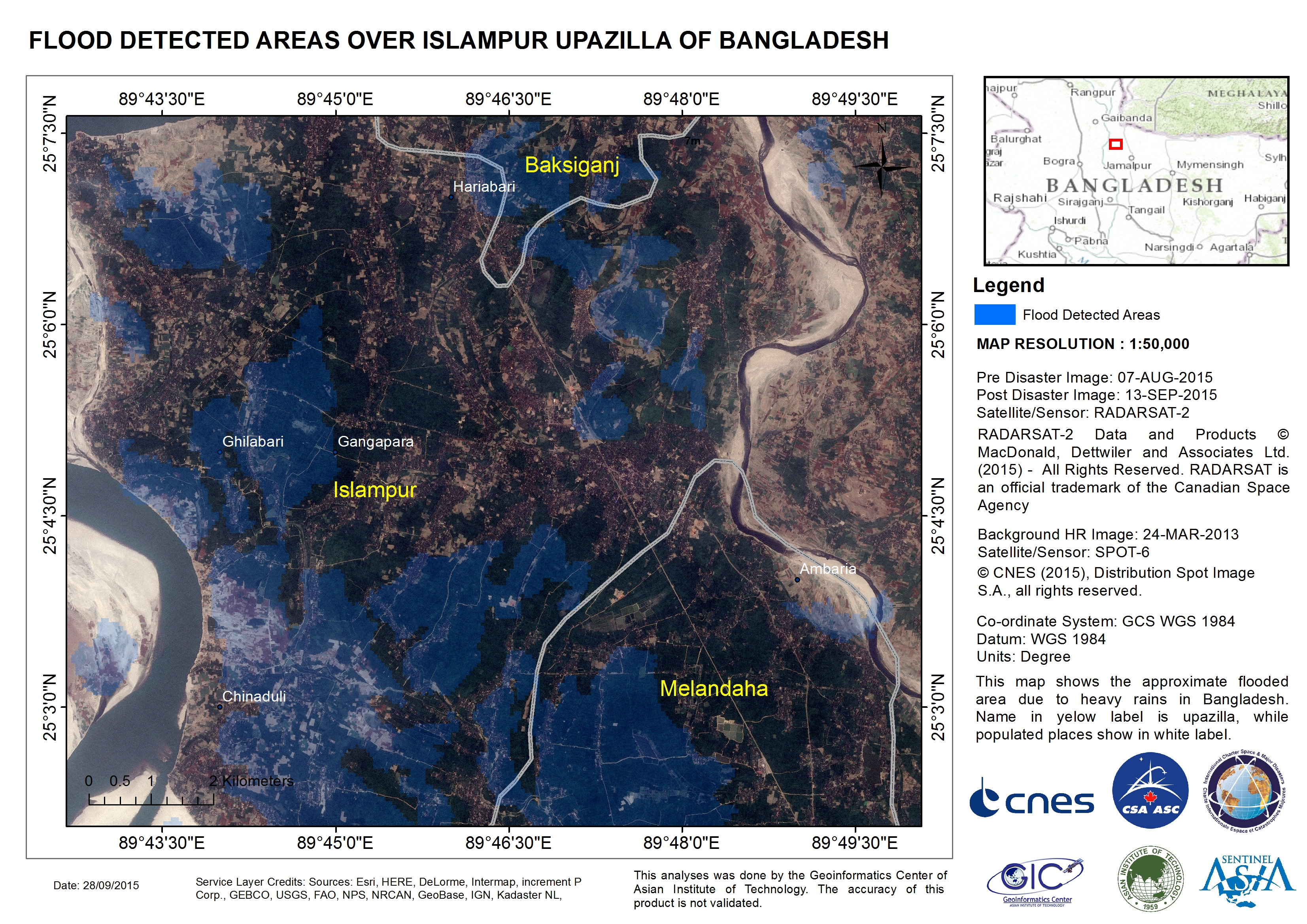
Flood detected areas over Islampur Upazilla of Bangladesh
版权: RADARSAT-2 Data and Products © MacDonald, Dettwiler and Associates Ltd. (2015) - All Rights Reserved. RADARSAT is an official trademark of the Canadian Space Agency.
SPOT-6 © CNES 2015 - Distribution: Airbus Defence and Space, all rights reserved
Map produced by Geoinformatics Center, Asian Institute of Technology
Information about the Product
已获得: RADARSAT-2: 07/08/2015 and 13/09/2015
SPOT-6: 24/03/2013
源: RADARSAT-2 / SPOT-6
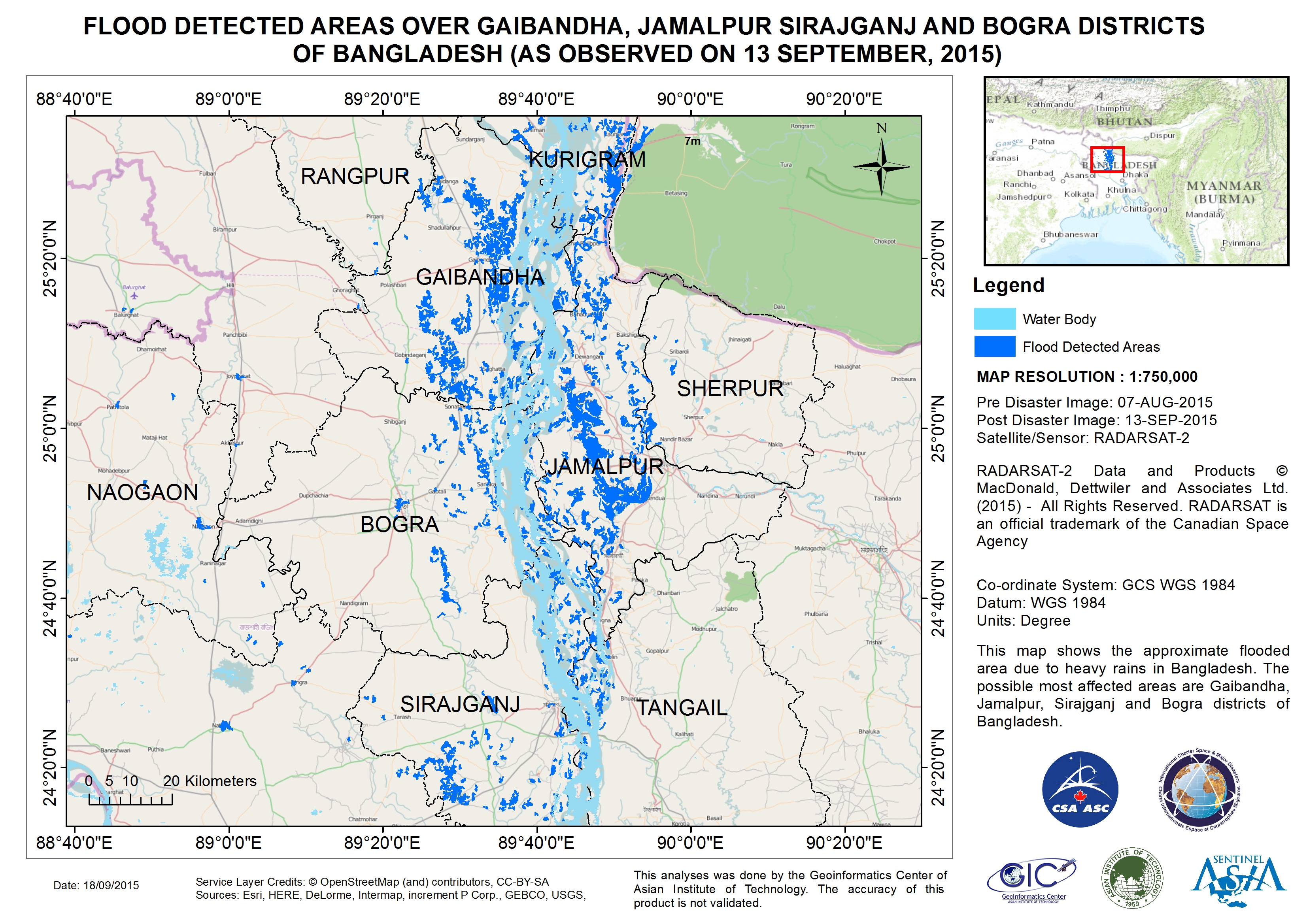
Flood detected areas over Gaibandha, Jamalpur Sirajganj and Bogra Districts of Bangladesh
版权: RADARSAT-2 Data and Products © MacDonald, Dettwiler and Associates Ltd. (2015) - All Rights Reserved. RADARSAT is an official trademark of the Canadian Space Agency.
Map produced by Geoinformatics Center, Asian Institute of Technology
Information about the Product
已获得: Pre-disaster: 07/08/2015
Post-disaster: 13/09/2015
源: RADARSAT-2
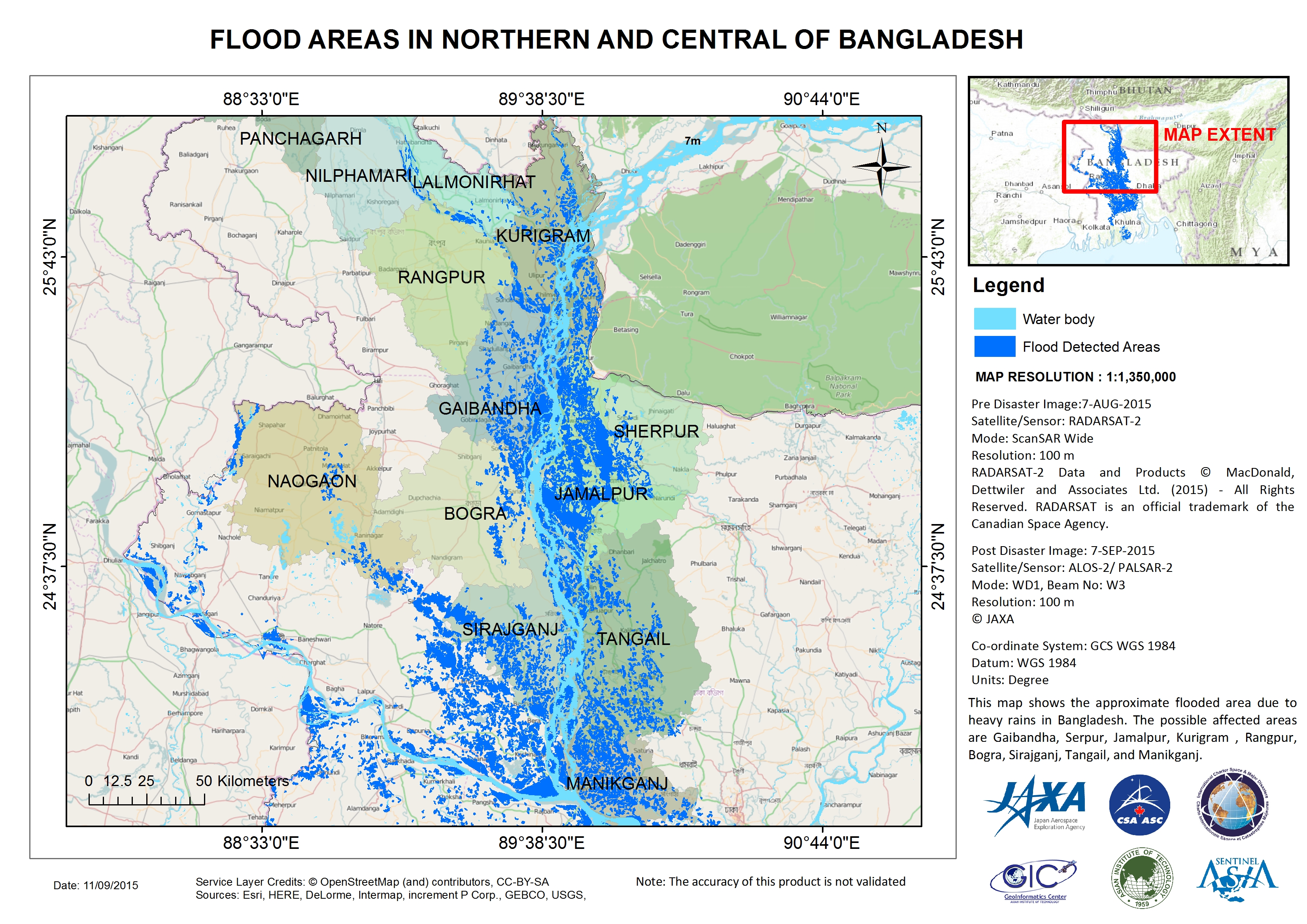
Flood areas in northern and central Bangladesh
版权: RADARSAT-2 Data and Products © MacDonald, Dettwiler and Associates Ltd. (2015) - All Rights Reserved. RADARSAT is an official trademark of the Canadian Space Agency.
ALOS © JAXA
Map produced by Geoinformatics Center, Asian Institute of Technology
Information about the Product
已获得: RADARSAT-2: 07/08/2015
ALOS-2: 07/09/2015
源: RADARSAT-2 / ALOS-2 PALSAR-2
 返回完整的响应档案

