 English
 Spanish
 French
 Chinese
 Russian
 Portuguese
 Последняя Активация
Charter activations
Flood in Bangladesh
Heavy rain has caused floods in the north and central regions of Bangladesh, affecting more than twenty of the country's districts.
No injuries or casualties have been reported, but the flooding has caused widespread disruption affecting thousands of people and hundreds of villages in the region. Roads have been flooded, making them inaccessible. Many people in the region have been left isolated by the floods, and relief efforts are underway to help those affected.
It has been reported that 14 major rivers were brought to dangerously high water levels.
The capital city of Dhaka has been impacted by the floods, leaving many homes in the lower-lying areas of the city inundated. There are concerns that these lingering flood waters may lead to outbreaks of disease.
| Тип события: | Flood |
| Место события: | Bangladesh |
| Date of Charter Activation: | 7 September 2015 |
| Время активации Хартии: | 09:13:20 |
| TЧасовой пояс в районе активации Хартии: | UTC+02:00 |
| Запрос на активацию поступил от: | Asia Disaster Reduction Center (ADRC) on behalf of Bangladesh Space Research and Remote Sensing Organization (SPARRSO) |
| Менеждер проекта от: | Asian Institute of Technology (AIT) |
Products
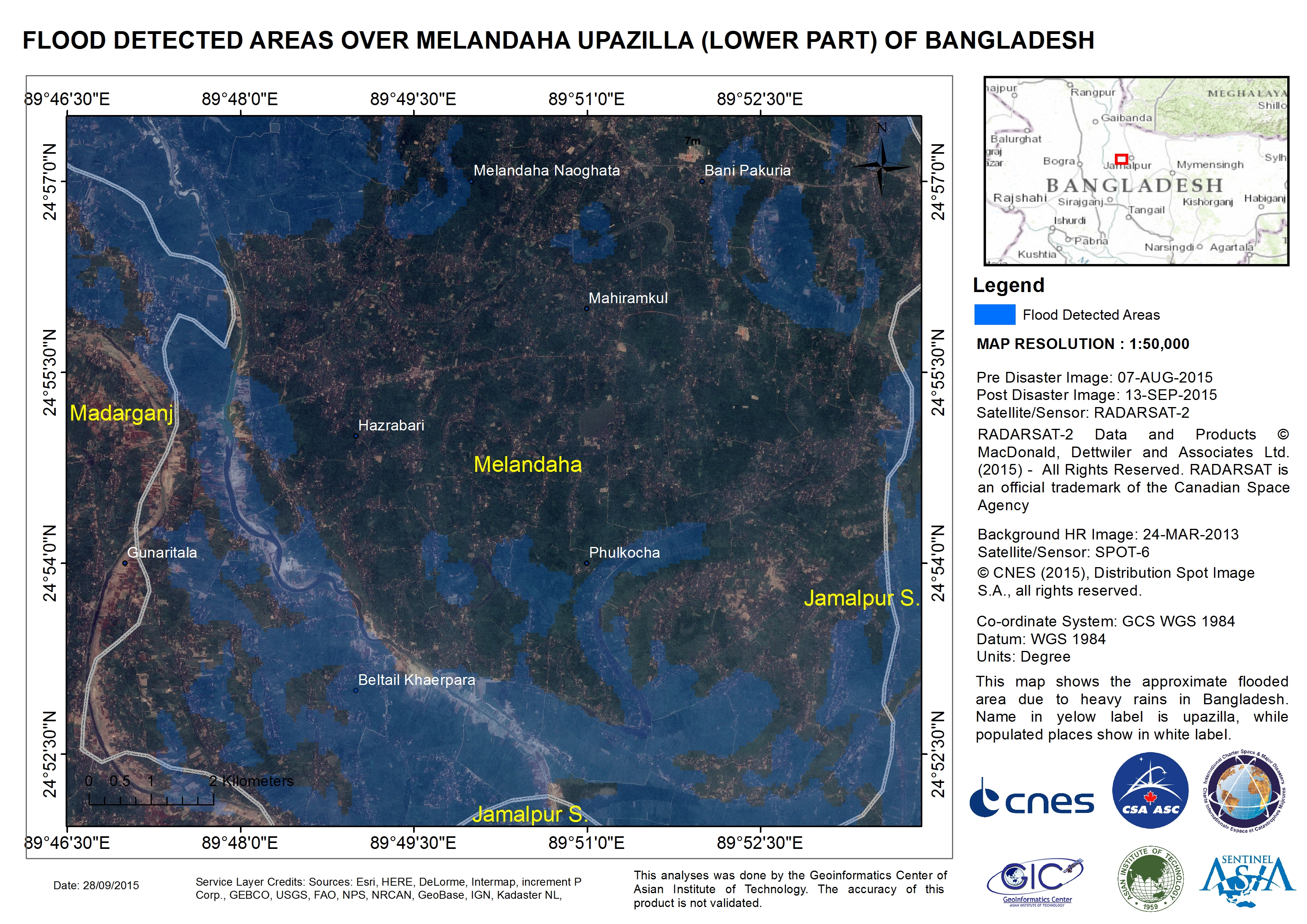
Flood detected areas over Melandaha Upazilla, in the lower part of Bangladesh
Авторские права: RADARSAT-2 Data and Products © MacDonald, Dettwiler and Associates Ltd. (2015) - All Rights Reserved. RADARSAT is an official trademark of the Canadian Space Agency.
SPOT-6 © CNES 2015 - Distribution: Airbus Defence and Space, all rights reserved
Map produced by Geoinformatics Center, Asian Institute of Technology
Information about the Product
Получено: RADARSAT-2: 07/08/2015 and 13/09/2015
SPOT-6: 24/03/2013
Источник: RADARSAT-2 / SPOT-6
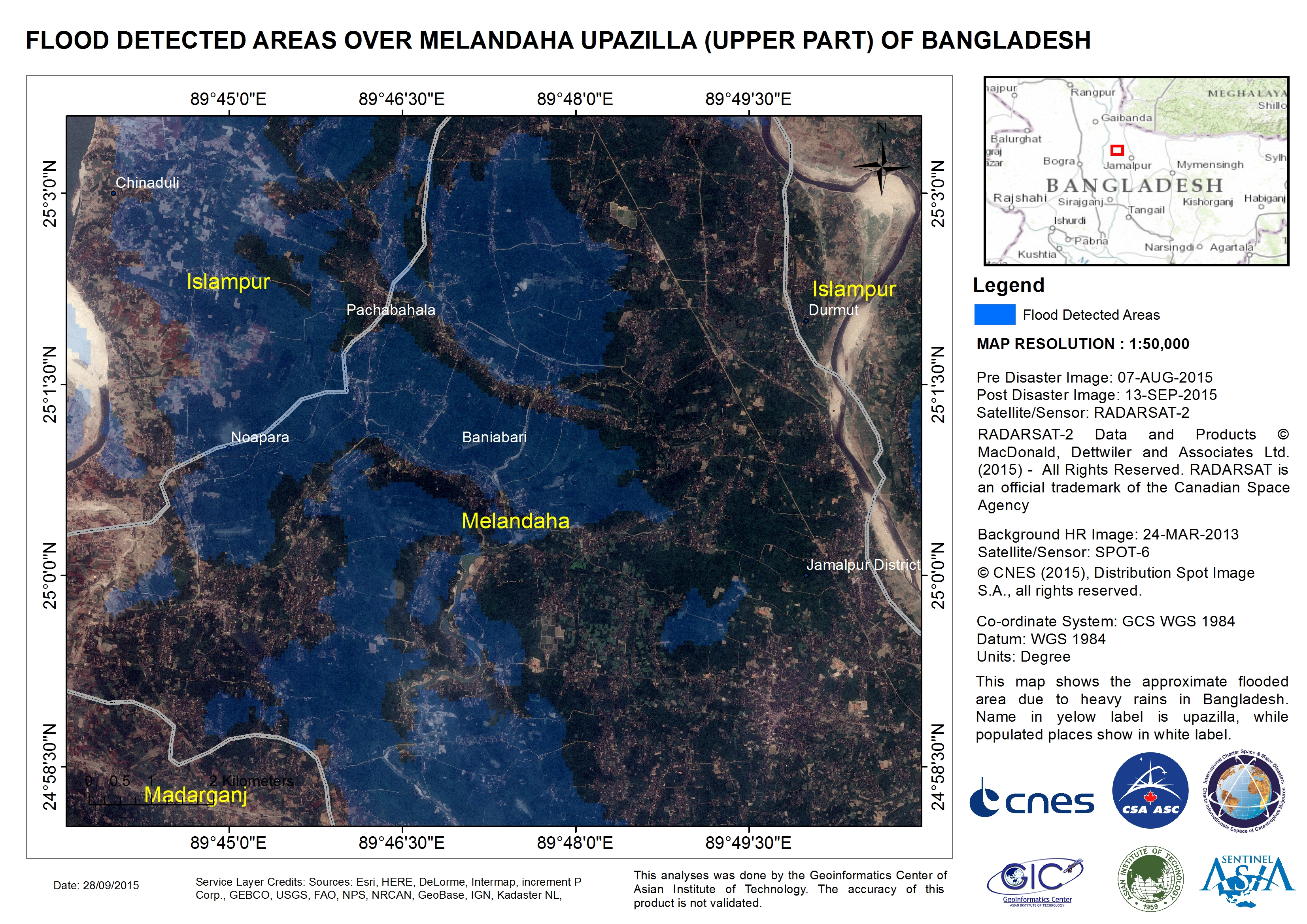
Flood detected areas over Melandaha Upazilla, in the upper part of Bangladesh
Авторские права: RADARSAT-2 Data and Products © MacDonald, Dettwiler and Associates Ltd. (2015) - All Rights Reserved. RADARSAT is an official trademark of the Canadian Space Agency.
SPOT-6 © CNES 2015 - Distribution: Airbus Defence and Space, all rights reserved
Map produced by Geoinformatics Center, Asian Institute of Technology
Information about the Product
Получено: RADARSAT-2: 07/08/2015 and 13/09/2015
SPOT-6: 24/03/2013
Источник: RADARSAT-2 / SPOT-6
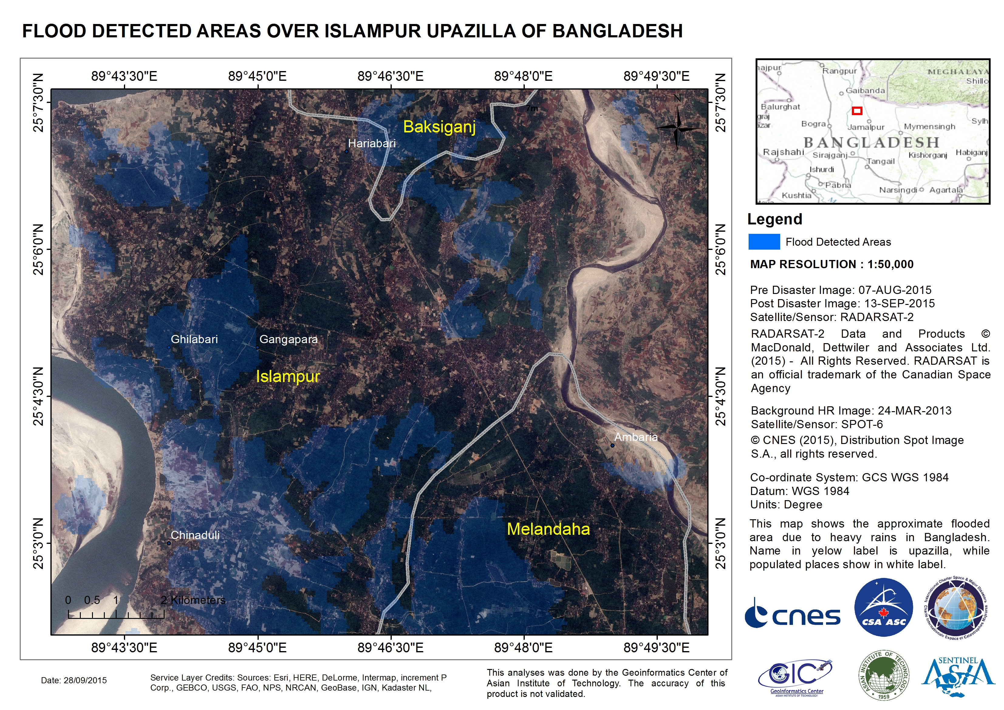
Flood detected areas over Islampur Upazilla of Bangladesh
Авторские права: RADARSAT-2 Data and Products © MacDonald, Dettwiler and Associates Ltd. (2015) - All Rights Reserved. RADARSAT is an official trademark of the Canadian Space Agency.
SPOT-6 © CNES 2015 - Distribution: Airbus Defence and Space, all rights reserved
Map produced by Geoinformatics Center, Asian Institute of Technology
Information about the Product
Получено: RADARSAT-2: 07/08/2015 and 13/09/2015
SPOT-6: 24/03/2013
Источник: RADARSAT-2 / SPOT-6
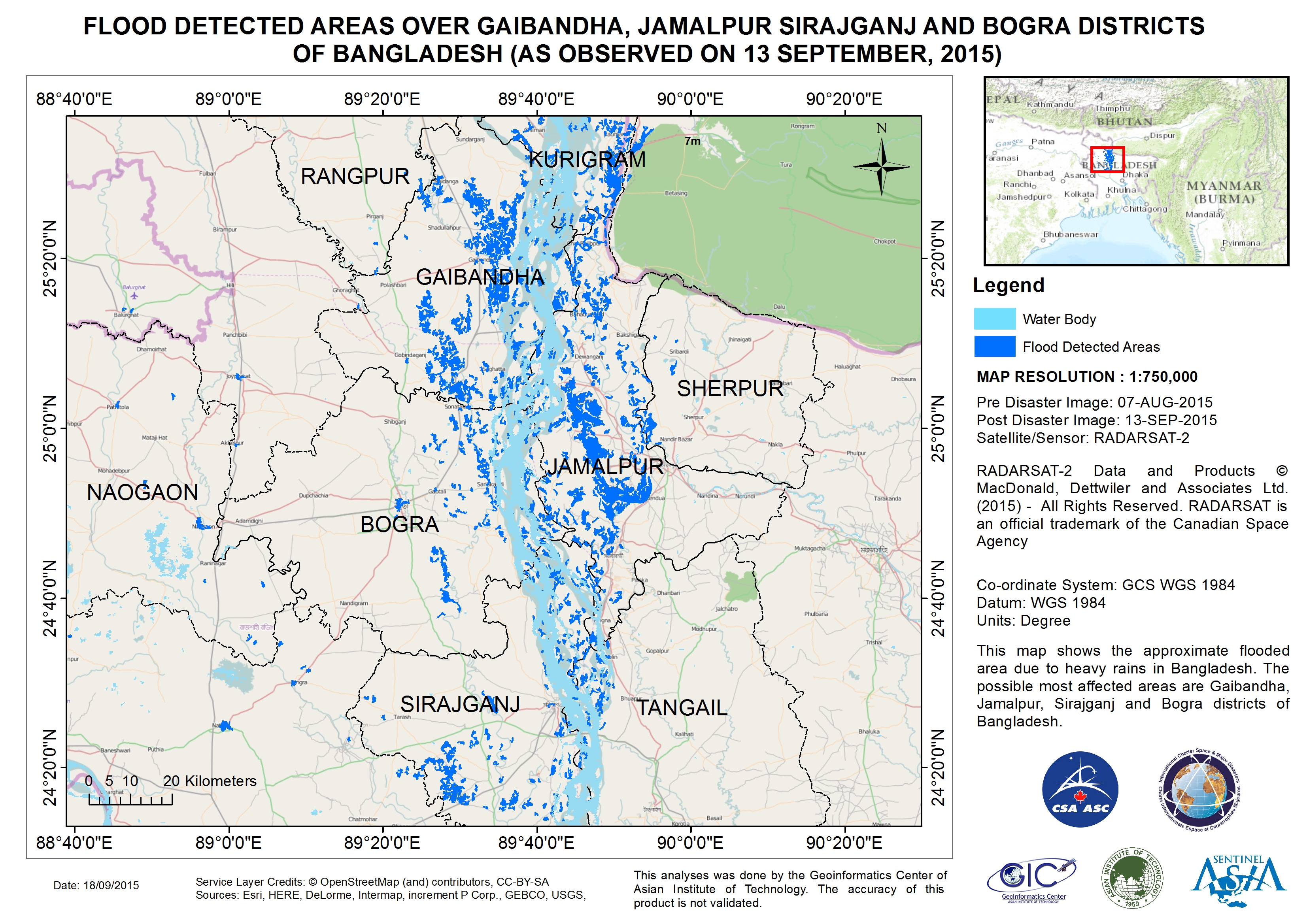
Flood detected areas over Gaibandha, Jamalpur Sirajganj and Bogra Districts of Bangladesh
Авторские права: RADARSAT-2 Data and Products © MacDonald, Dettwiler and Associates Ltd. (2015) - All Rights Reserved. RADARSAT is an official trademark of the Canadian Space Agency.
Map produced by Geoinformatics Center, Asian Institute of Technology
Information about the Product
Получено: Pre-disaster: 07/08/2015
Post-disaster: 13/09/2015
Источник: RADARSAT-2
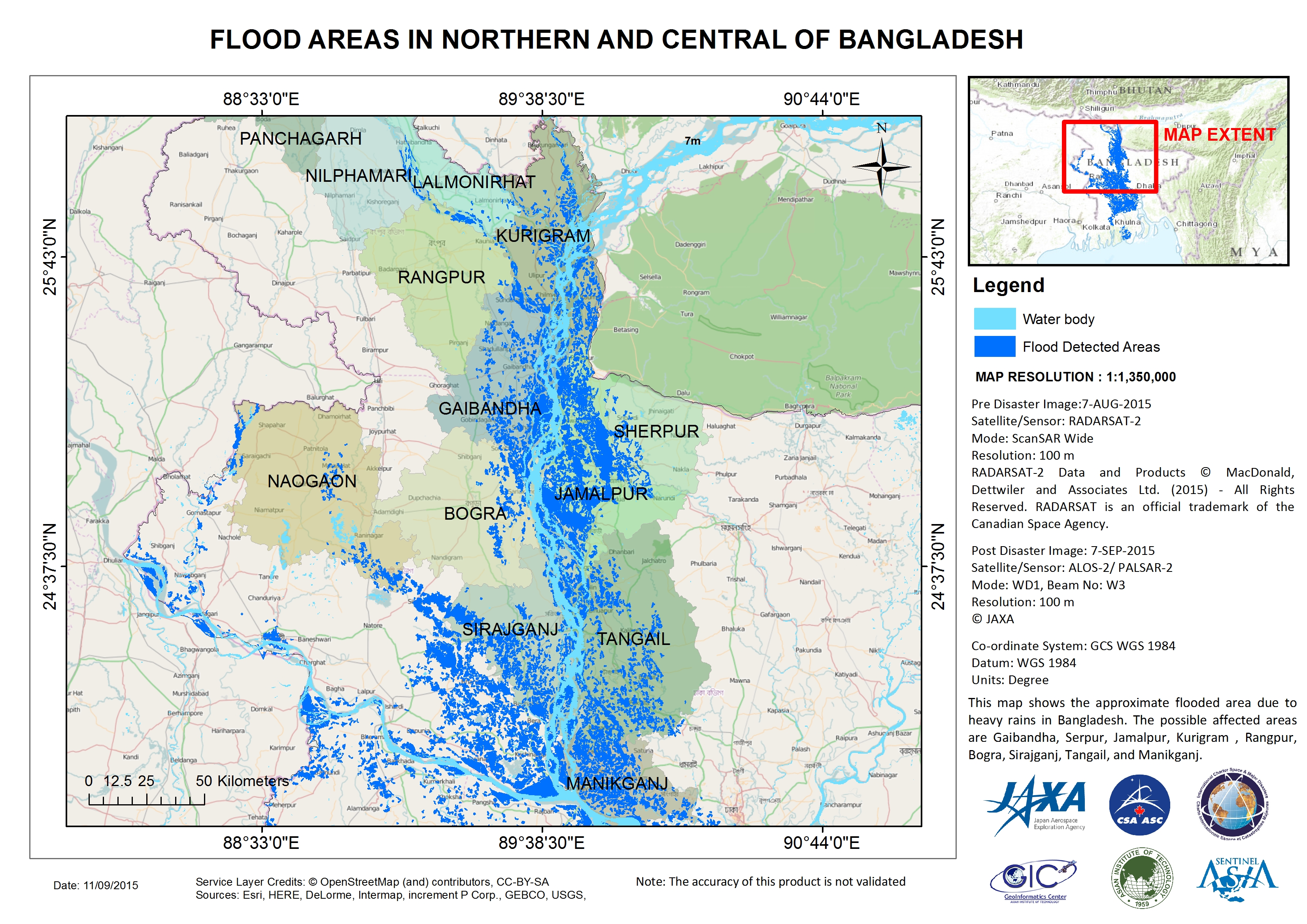
Flood areas in northern and central Bangladesh
Авторские права: RADARSAT-2 Data and Products © MacDonald, Dettwiler and Associates Ltd. (2015) - All Rights Reserved. RADARSAT is an official trademark of the Canadian Space Agency.
ALOS © JAXA
Map produced by Geoinformatics Center, Asian Institute of Technology
Information about the Product
Получено: RADARSAT-2: 07/08/2015
ALOS-2: 07/09/2015
Источник: RADARSAT-2 / ALOS-2 PALSAR-2
 Вернуться к полному архиву активаций

