 English
 Spanish
 French
 Chinese
 Russian
 Portuguese
 最新宪章启动
Charter activations
瓦努阿图飓风
2015年3月13日和14日,飓风 "帕姆"于越过瓦努阿图,过境后造成至少11人死亡和极大破坏。
该风暴的破坏力已被描述为瓦努阿图历史上最严重的灾难。瓦努阿图是南太平洋上的一个岛国,由82个岛屿组成。
3月13日,"帕姆"通过埃法特岛附近,该岛上坐落着瓦努阿图首都维拉港。当时风暴强度为5级,这在萨菲尔 - 辛普森量表中为最高级。
从那里起,风暴向南移动,越过埃罗芒阿岛和岛屿塔纳,并于3月14日通过阿内蒂乌姆岛。
3月14日,瓦努阿图总统描述了由风暴造成的破坏,呼吁国际援助。据报道,90%的维拉港已被破坏,而且几乎城市里的每个家庭都遭受部分损坏。而即将到来的飓风预警意味着居民有时间在急救中心暂避,风暴经过木屋和电力线路时,在整个区域留下了四处散落的碎片。
风暴过后,恢复工作很快开始,国际援助已抵达该群岛。据悉成千上万的人无家可归。因为通信被风暴切断,南部岛屿受到救援人员的极大关注,。目前还不清楚这些岛屿情况,飓风引起的洪水使得飞机难以或不可能降落在岛上。
3月17日,救援开始到达其他受影响的岛屿,救援人员评估那里居民的需求。他们发现塔纳岛上80%的建筑物(30,000人居住的房屋)已被飓风帕姆摧毁或损坏。
| 事件类型: | 飓风 |
| 事件地点: | 瓦努阿图 |
| 启动宪章的日期: | 2015年3月12日 |
| 宪章启动时间: | 14:14:52 |
| 宪章启动时区: | UTC+01:00 |
| 宪章要求者: | UNITAR/UNOSAT 代表 UNOCHA |
| 项目经理: | UNITAR/UNOSAT |
Products
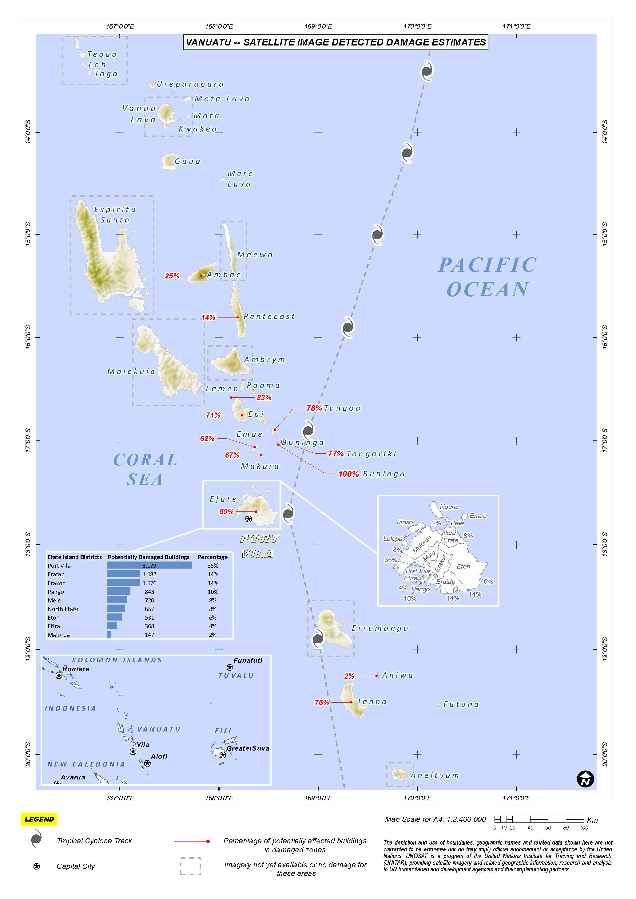
Satellite image detected damage estimates in Vanuatu
Download the full report
版权: WorldView-1 and 2 © DigitalGlobe Inc.
Pleiades © CNES 2015 - Distribution: Airbus Defence and Space, all rights reserved
Report produced by UNITAR/UNOSAT
Information about the Product
已获得: WorldView-1: 17/03/2015
WorldView-2: 15/03/2015, 16/03/2015, 18/03/2015
Pleiades: 15/03/2015, 16/03/2015, 17/03/2015, 19/03/2015
源: WorldView-1 / WorldView-2 / Pleiades
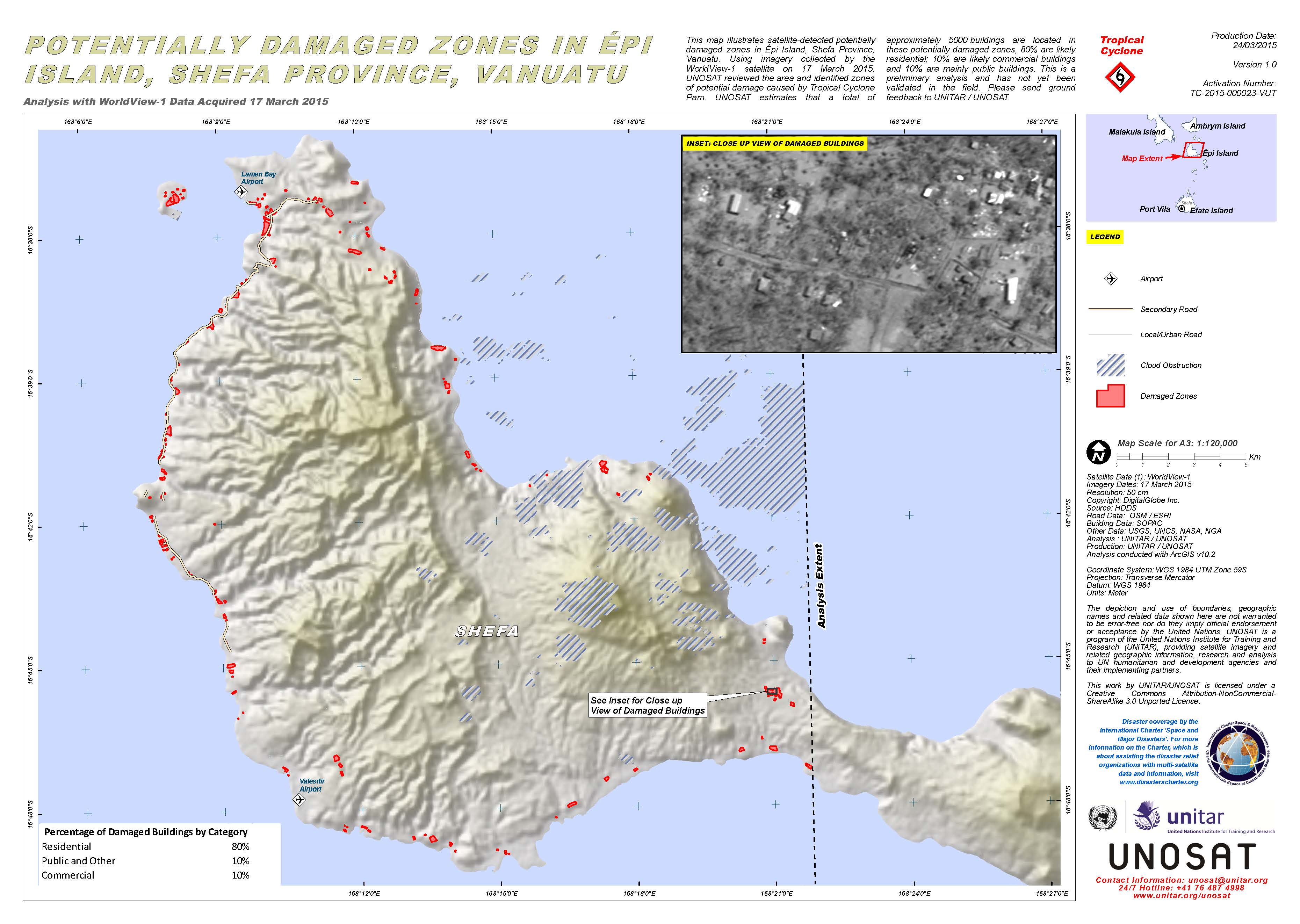
Potentially damaged zones in Epi Island, Shefa Province, in Vanuatu
版权: DigitalGlobe Inc.
Map produced by UNITAR/UNOSAT
Information about the Product
已获得: 17/03/2015
源: WorldView-1
Other Result
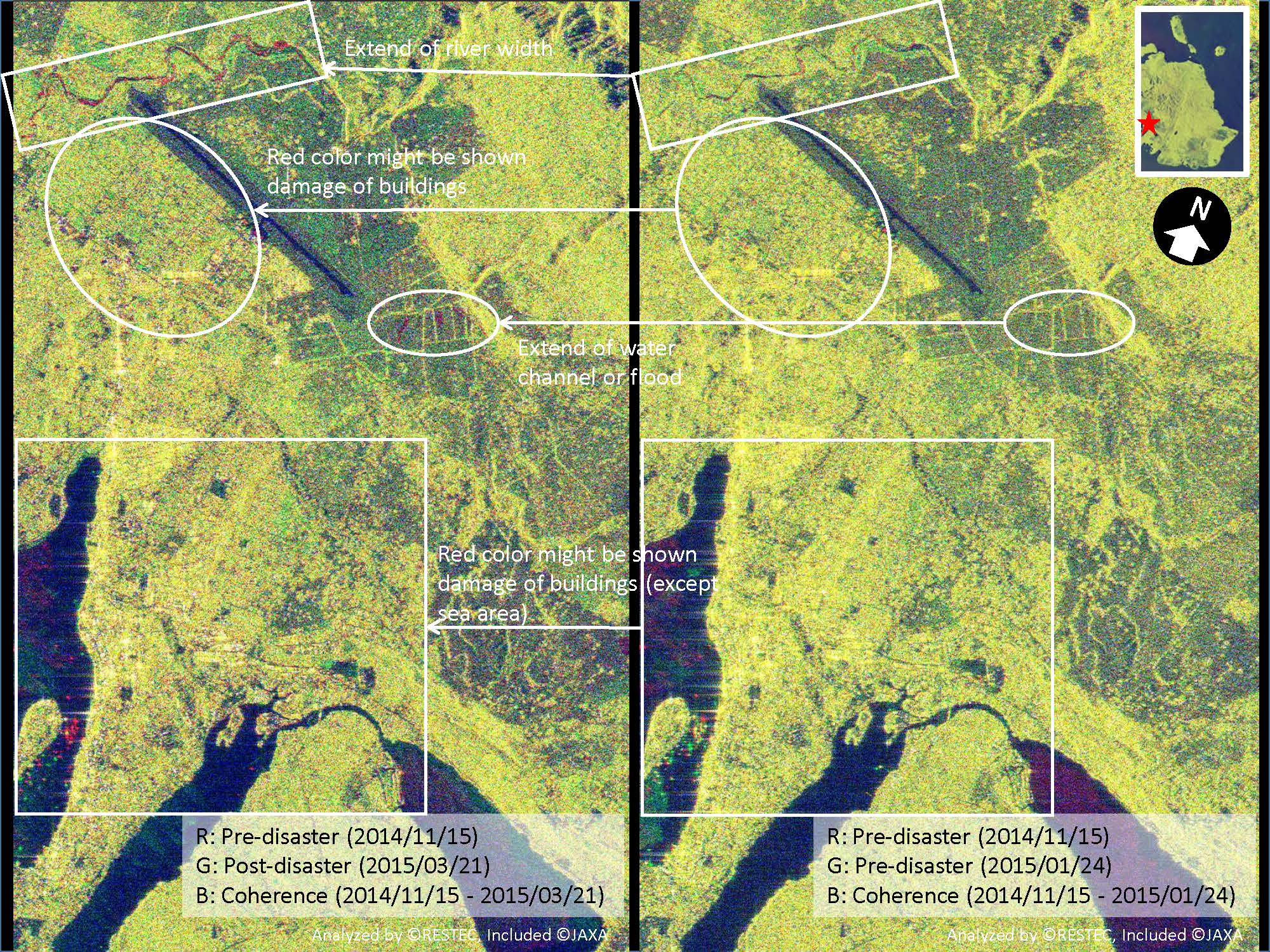
Analytical result of Cyclone Pam in Vanuatu
Download the full report
版权: RESTEC / JAXA
Report created by JAXA
Information about the Product
已获得: 15/11/2014, 24/01/2015, 21/03/2015
源: ALOS-2/PALSAR-2
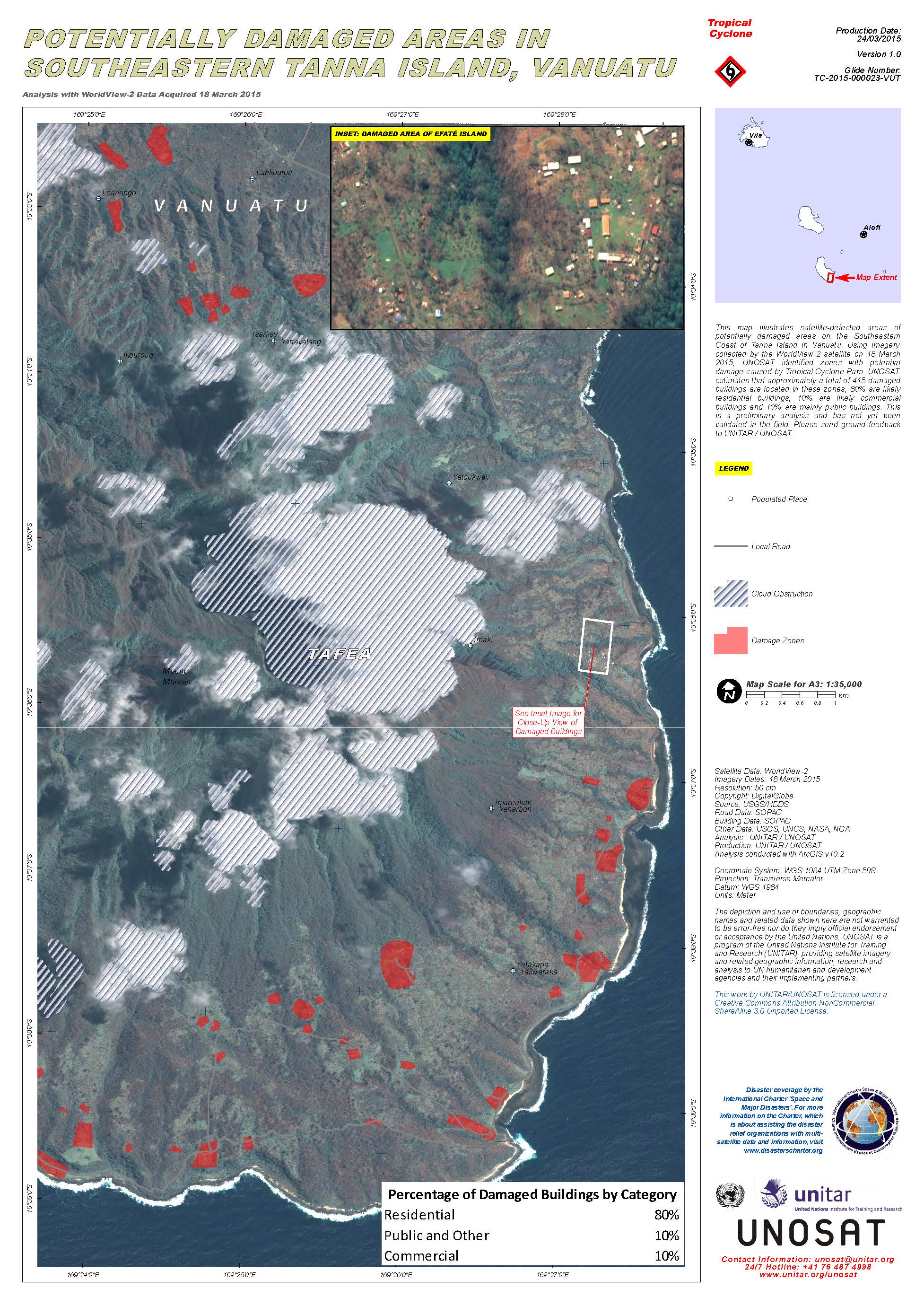
Potentially damaged areas in southeastern Tanna Island, Vanuatu
版权: DigitalGlobe Inc.
Map produced by UNITAR/UNOSAT
Information about the Product
已获得: 18/03/2015
源: WorldView-2
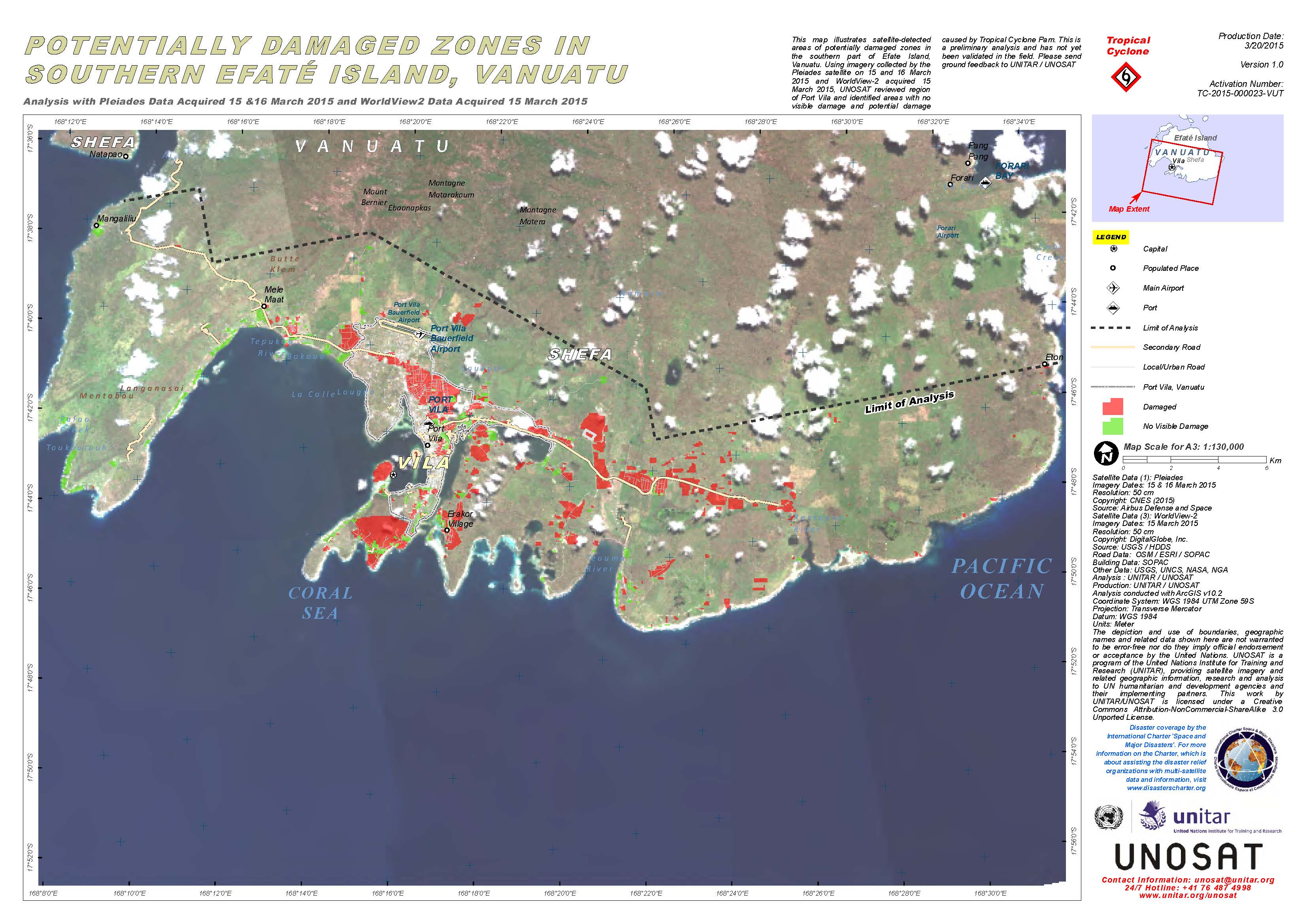
Potentially damages zones in southern Efate Island, Vanuatu
版权: Pleiades © CNES 2015 - Distribution: Airbus Defence and Space, all rights reserved
WorldView-2 © DigitalGlobe Inc.
Map produced by UNITAR/UNOSAT
Information about the Product
已获得: Pleiades: 15/03/2015 and 16/03/2015
WorldView-2: 15/03/2015
源: Pleiades / WorldView-2
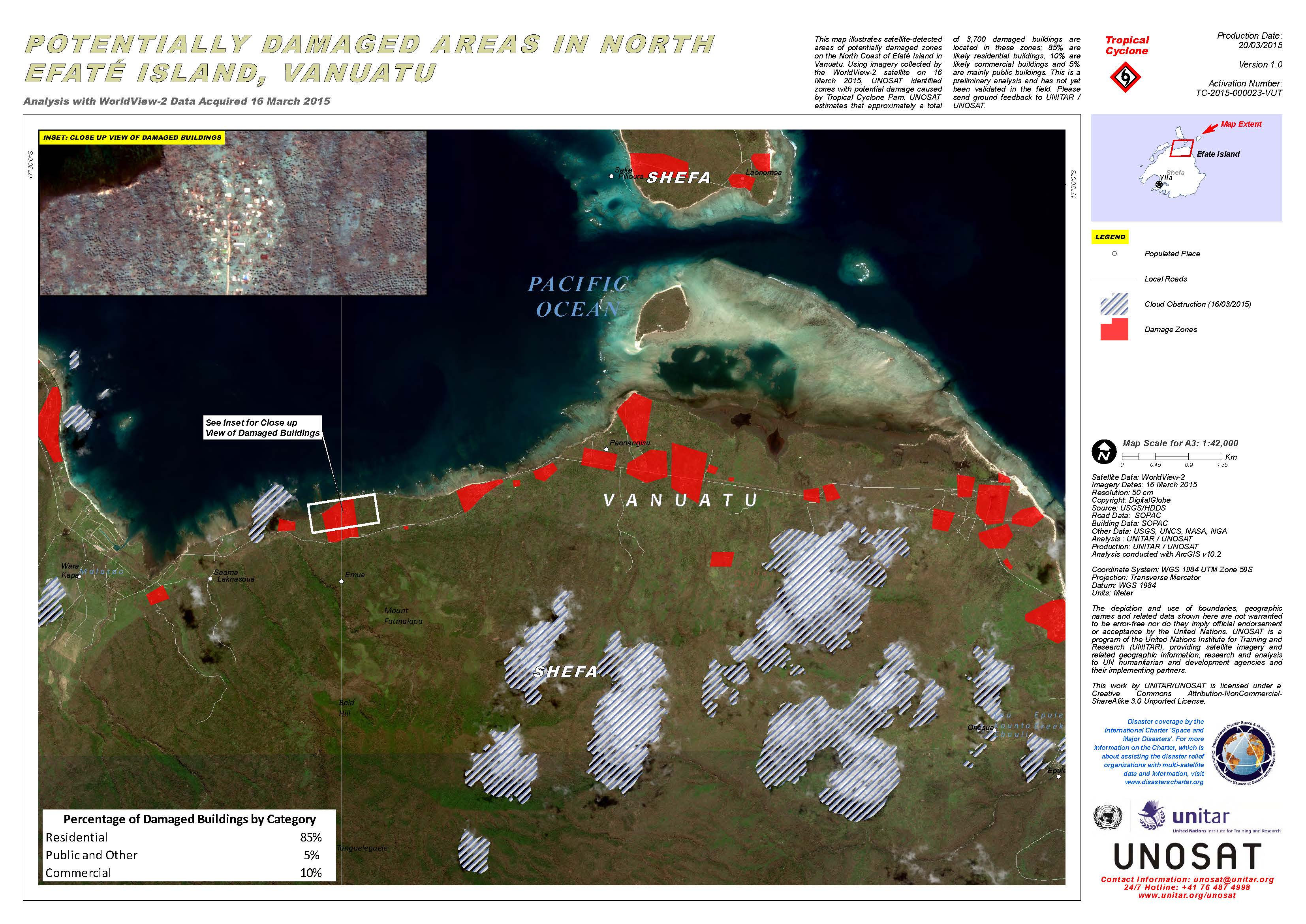
Potentially damaged areas in north Efate Island, Vanuatu
版权: DigitalGlobe
Map produced by UNITAR/UNOSAT
Information about the Product
已获得: 16/03/2015
源: WorldView-2
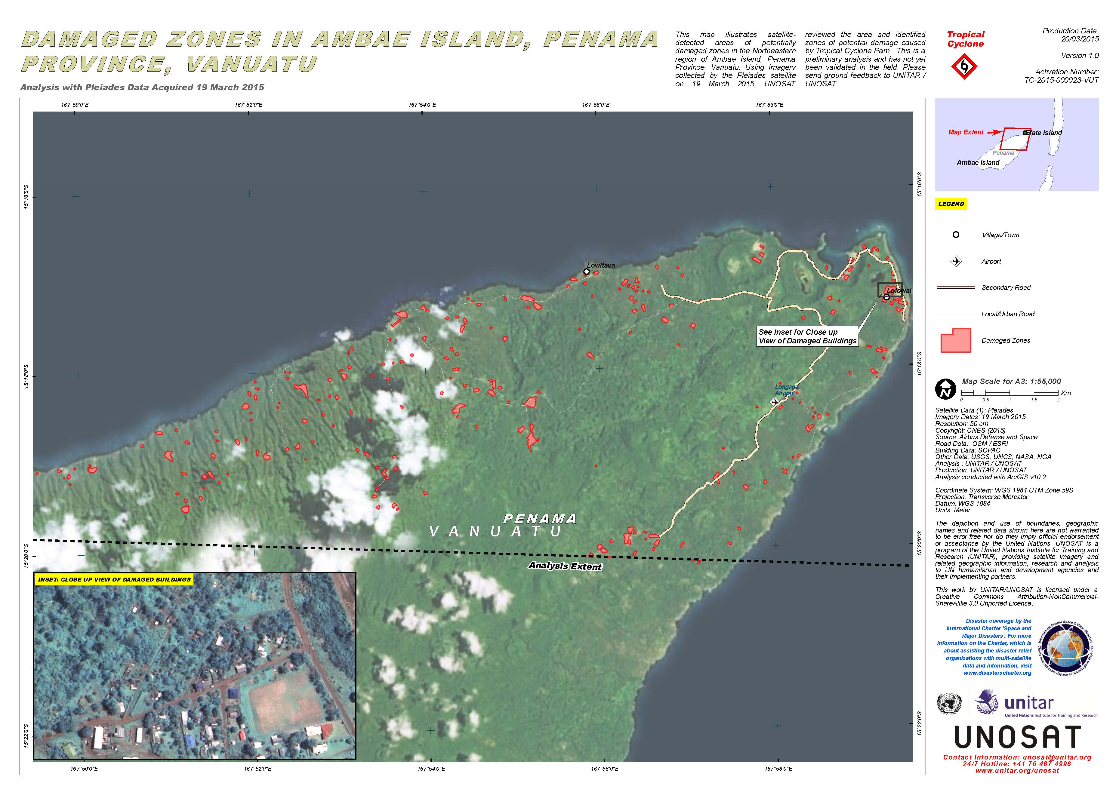
Damaged zones in Ambae Island, Penama Province, in Vanuatu
版权: CNES 2015 - Distribution: Airbus Defence and Space, all rights reserved
Map produced by UNITAR/UNOSAT
Information about the Product
已获得: 19/03/2015
源: Pleiades
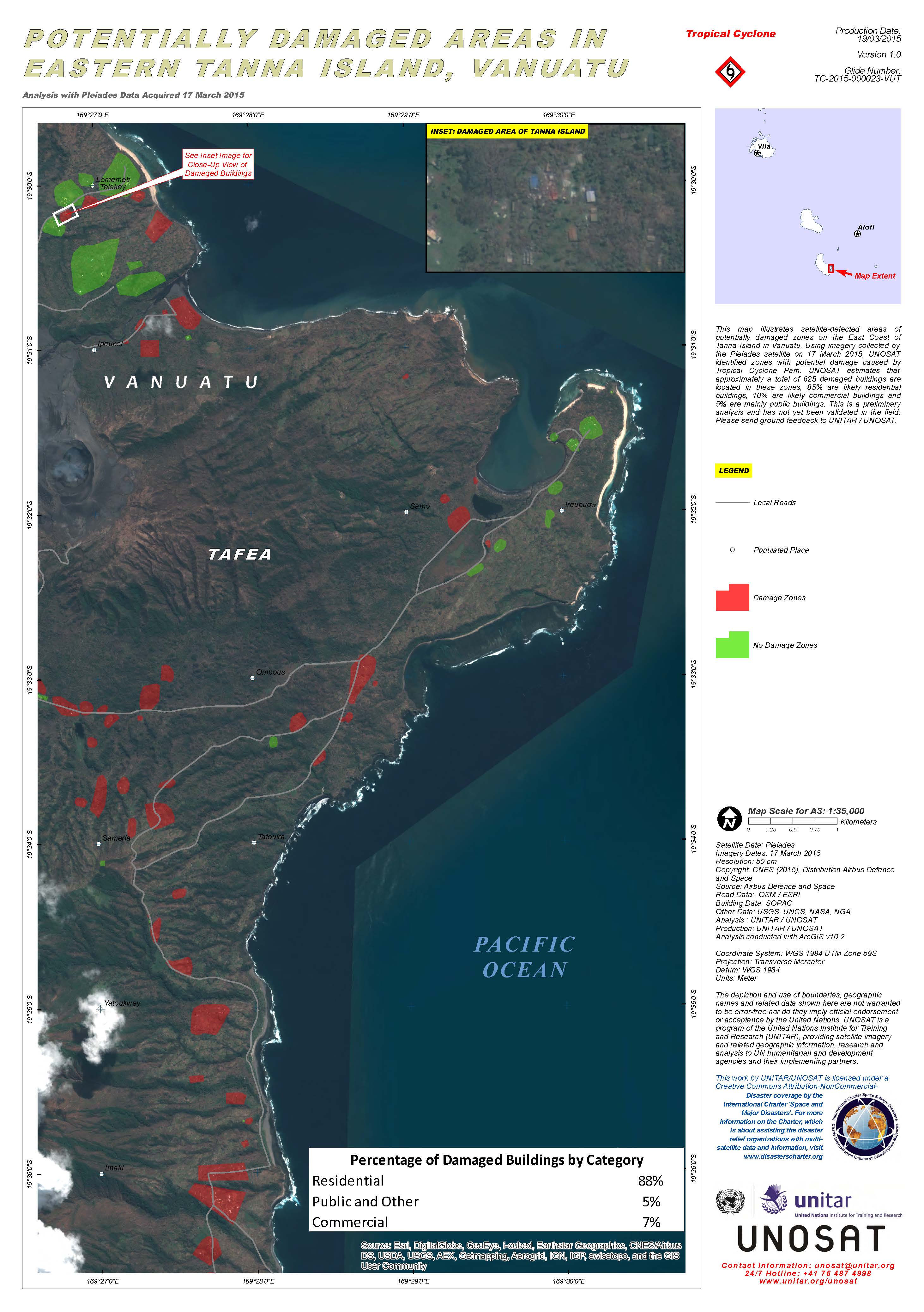
Potentially damaged areas in eastern Tanna Island, Vanuatu
版权: CNES 2015 - Distribution: Airbus Defence and Space, all rights reserved
Map produced by UNITAR/UNOSAT
Information about the Product
已获得: 17/03/2015
源: Pleiades
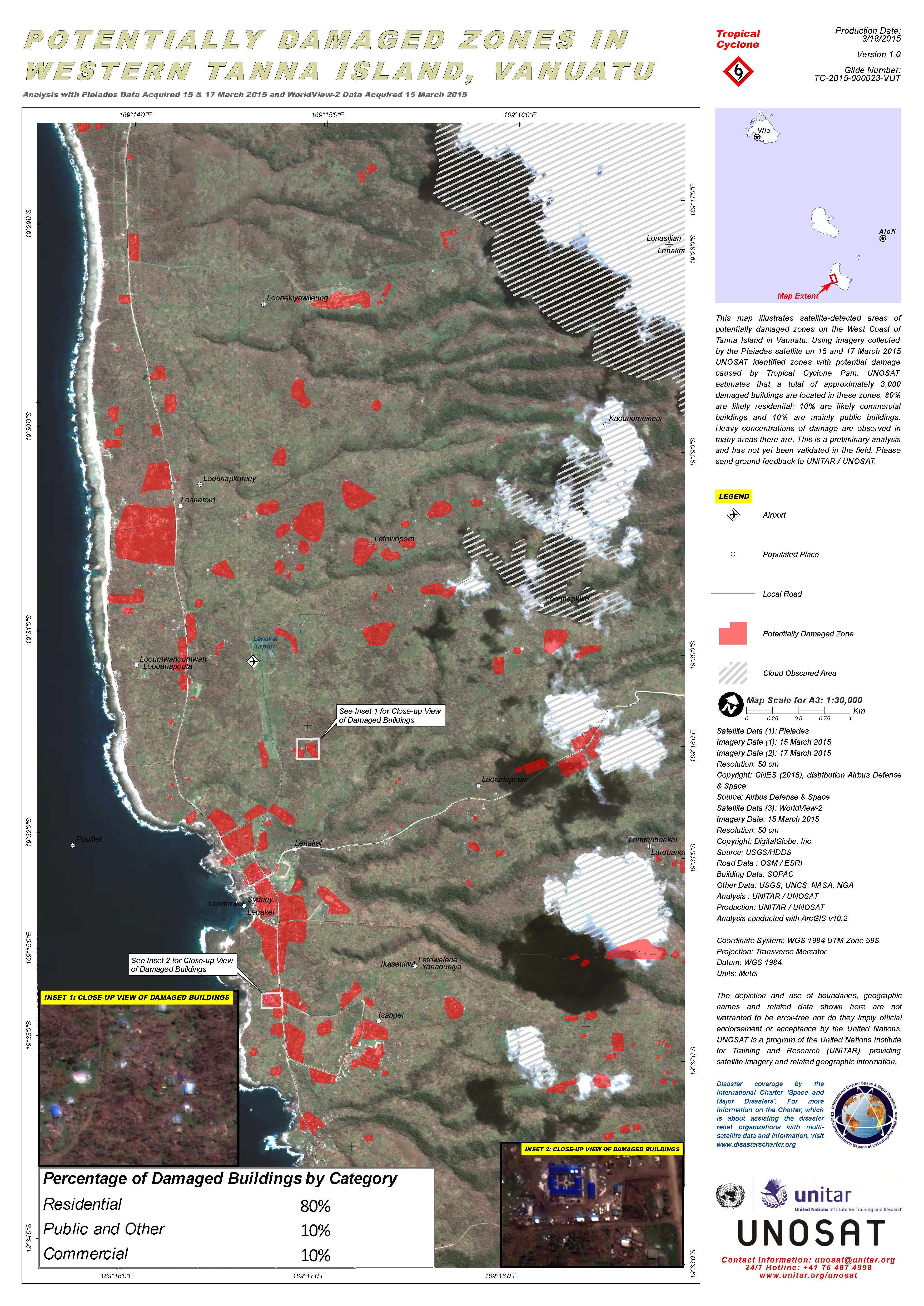
Potentially damaged zones in western Tanna Island, Vanuatu
版权: Pleiades © CNES 2015 - Distribution: Airbus Defence and Space, all rights reserved
WorldView-2 © DigitalGlobe Inc.
Map produced by UNITAR/UNOSAT
Information about the Product
已获得: Pleiades: 15/03/2015 and 17/03/2015
WorldView-2: 15/03/2015
源: Pleiades / WorldView-2
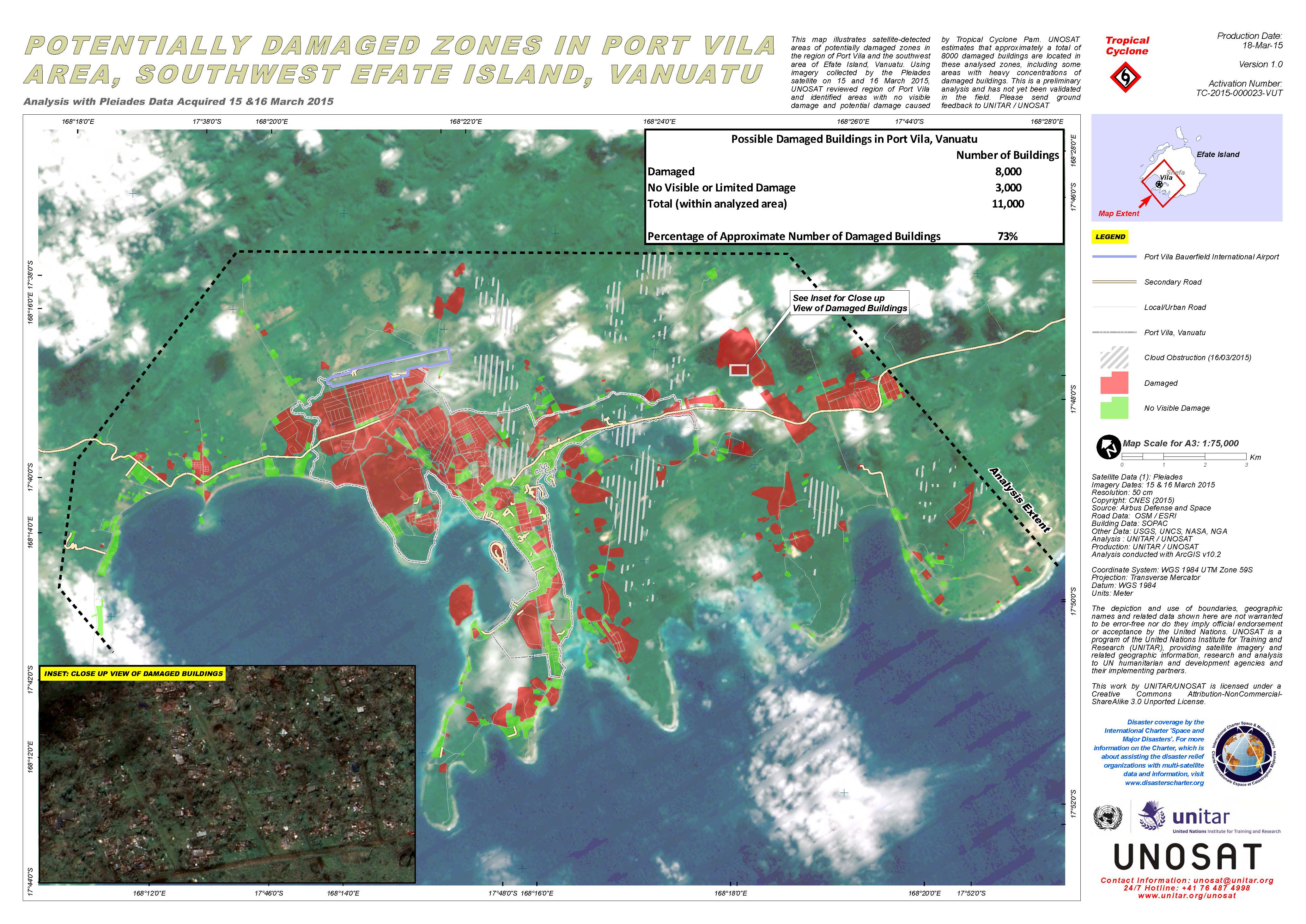
Potentially damaged zones in Port Vila, southwest Efate Island, Vanuatu
版权: CNES 2015 - Distribution: Airbus Defence and Space, all rights reserved
Map produced by UNITAR/UNOSAT
Information about the Product
已获得: 15/03/2015 and 16/03/2015
源: Pleiades
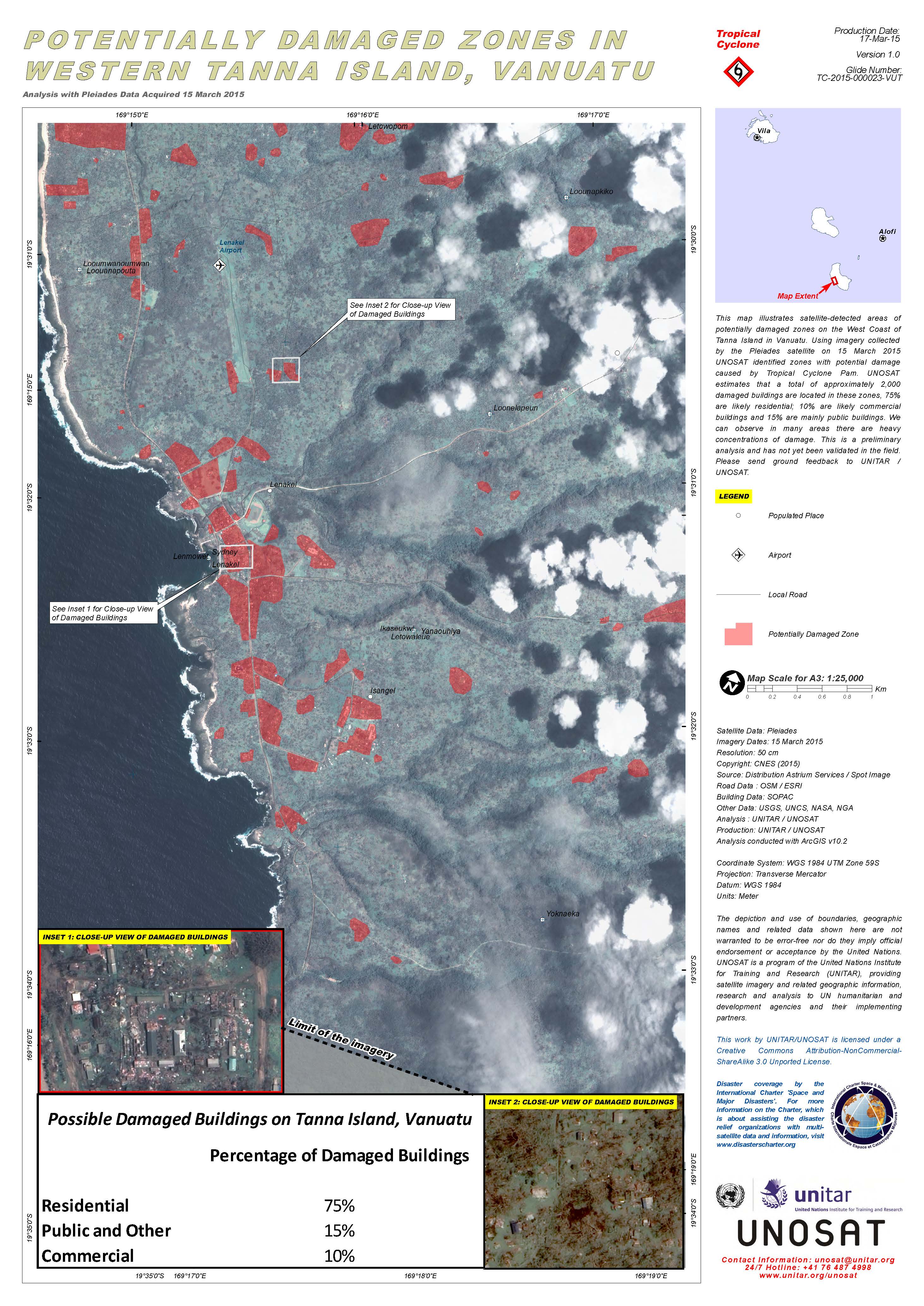
Potentially damaged zones in western Tanna island, Vanuatu
版权: CNES 2015 - Distribution: Airbus Defence and Space, all rights reserved
Map produced by UNITAR/UNOSAT
Information about the Product
已获得: 15/03/2015
源: Pleiades
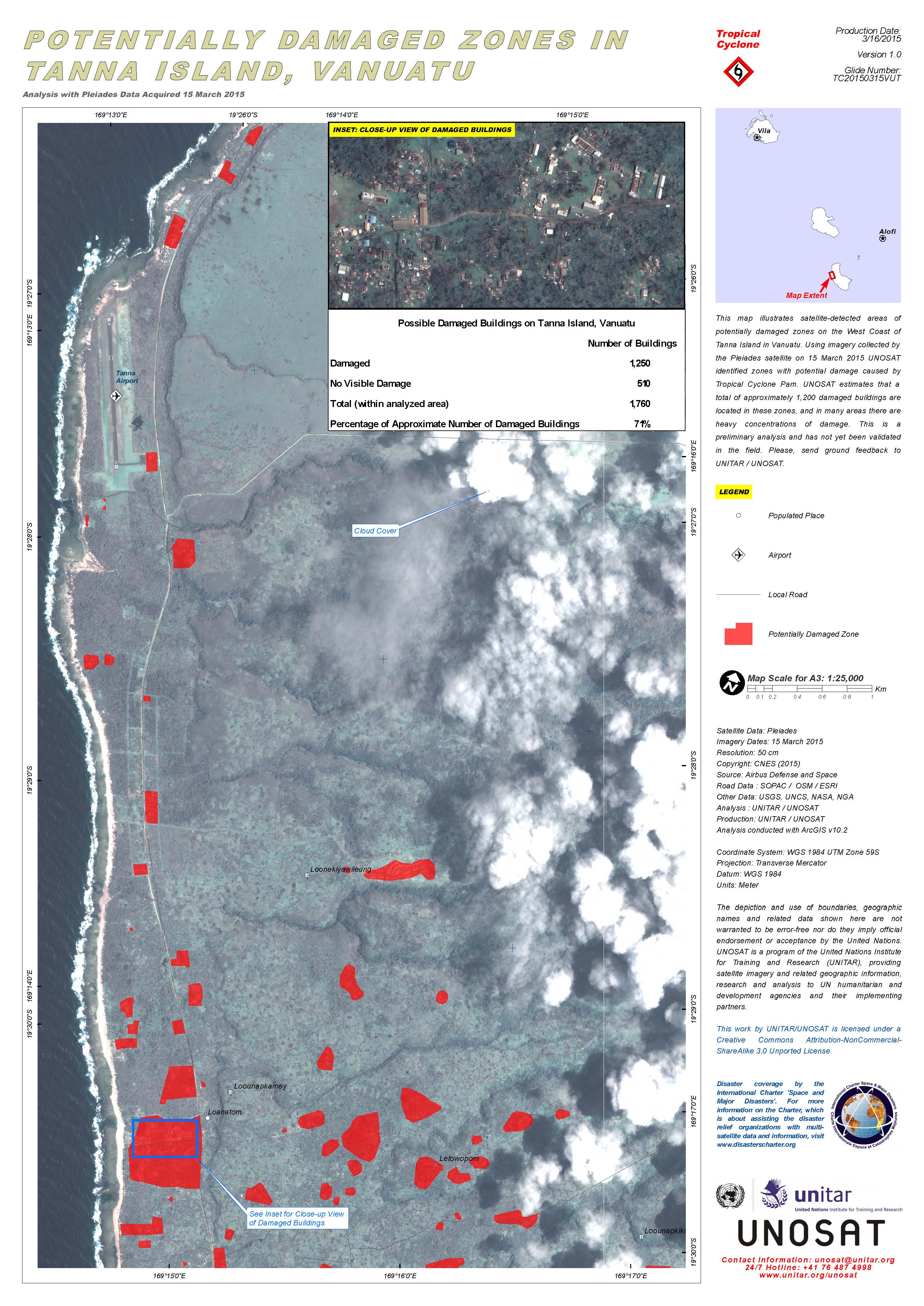
Potentially damaged zones in Tanna island, Vanuatu
版权: CNES 2015 - Distribution: Airbus Defence and Space, all rights reserved
Map produced by UNITAR/UNOSAT
Information about the Product
已获得: 15/03/2015
源: Pleiades
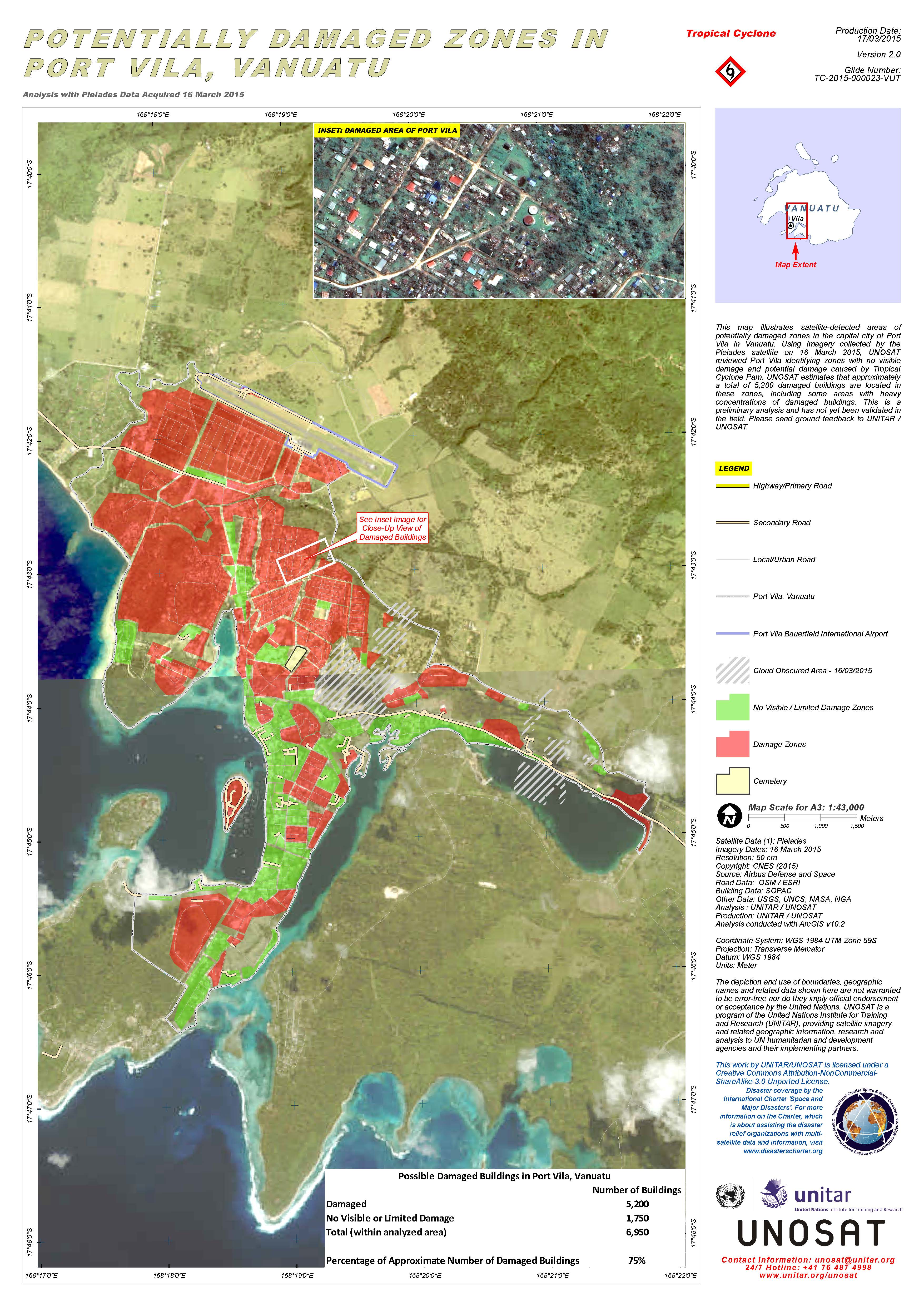
Potentially damaged zones in Port Vila, Vanuatu
版权: CNES 2015 - Distribution: Airbus Defence and Space, all rights reserved
Map produced by UNITAR/UNOSAT
Information about the Product
已获得: 16/03/2015
源: Pleiades
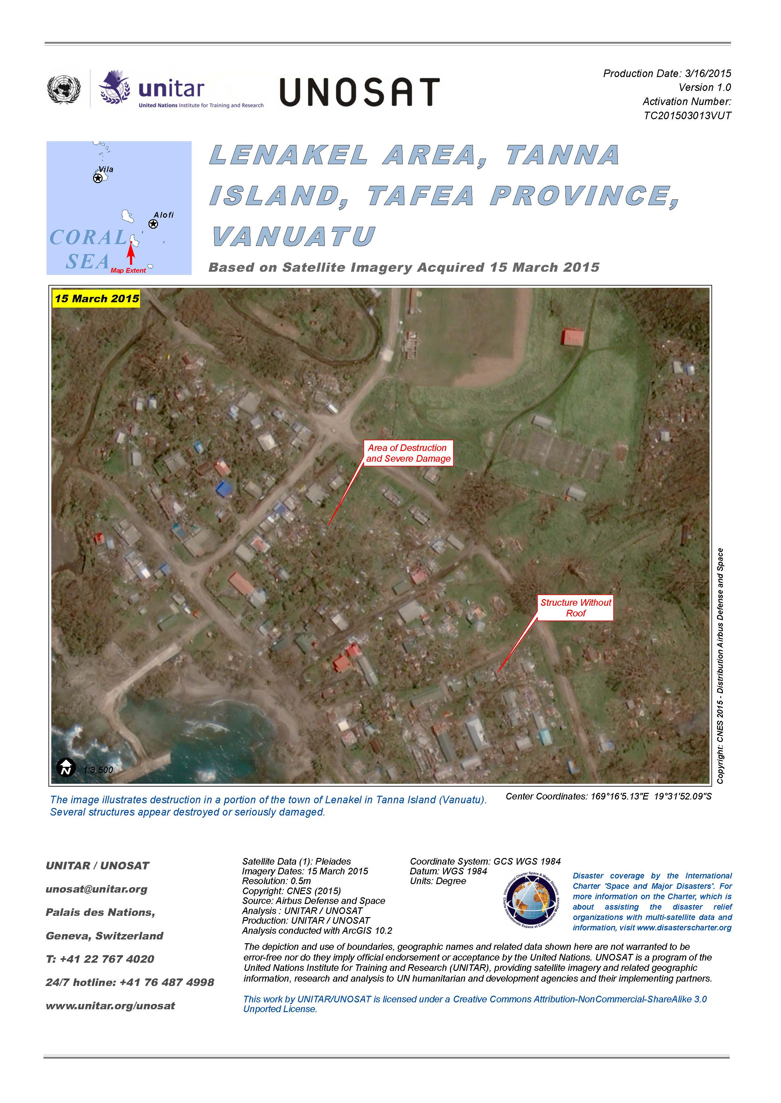
Destruction in the Lenakel area, Tanna island, in Tafea Province, Vanuatu, after Cyclone Pam.
版权: CNES 2015 - Distribution: Airbus Defence and Space, all rights reserved
Map produced by UNITAR/UNOSAT
Information about the Product
已获得: 15/03/2015
源: Pleiades
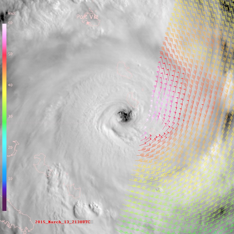
MTSAT view of the eye of Cyclone Pam on 13 March 2015, south of Port Vila.
Read more about the image in EUMETSAT's case study.
版权: EUMETSAT
Information about the Product
已获得: 13/03/2015
源: MTSAT / MetOp
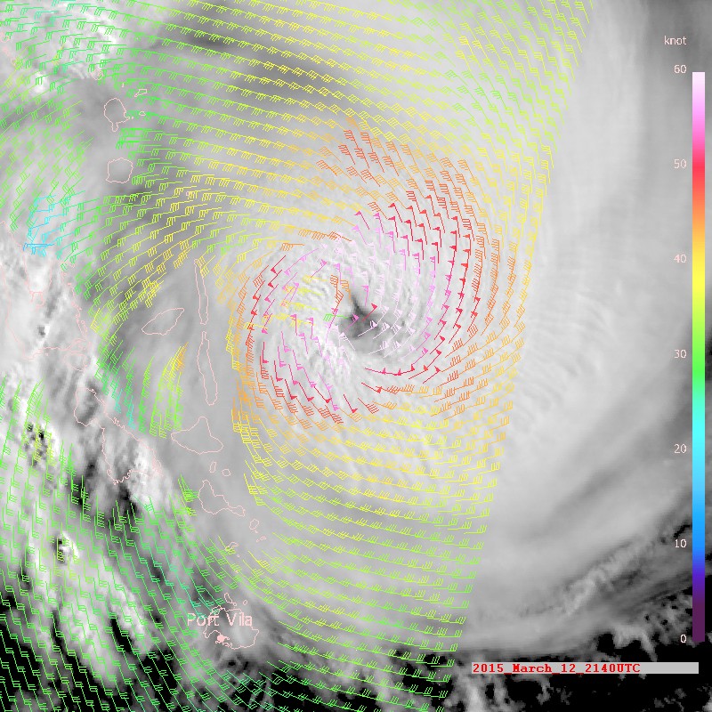
MTSAT view of Cyclone Pam on 12 March 2015 off the coast of Vanuatu.
Read more about the image in EUMETSAT's case study.
版权: EUMETSAT
Information about the Product
已获得: 12/03/2015
源: MTSAT / MetOp
 返回完整的响应档案

