 English
 Spanish
 French
 Chinese
 Russian
 Portuguese
 Latest Activation
Charter activations
Tropical Cyclone Lola in Vanuatu
Tropical Cyclone Lola formed over the South Pacific Ocean on 21 October 2023 and started moving towards Vanuatu.
Making landfall on the 24 of October 2023 the Vanuatu Meteorology Department upgraded the cyclone to category 5 and winds brought by Lola were estimated up to 230 kph at the centre of the storm. Multiple provinces in the country's north and central areas specifically Torba, Sanma, Penama, Malampa, and Shefa were badly affected. As the storm progressed it was downgraded to a category 4. Lola is Vanuatu's third major storm in seven months.
The eastern side of the Solomon islands was also at risk and weather warnings were issued for heavy rain, damaging winds and possible landslides.
Cyclone season typically runs from 1 November to 30 April, making Cyclone Lola only the seventh pre-season South Pacific cyclone to form in October since 1970.
Related News and Resources
| Type of Event: | Cyclones |
| Location of Event: | Vanuatu |
| Date of Charter Activation: | 2023-10-23 |
| Time of Charter Activation: | 10:50 |
| Time zone of Charter Activation: | UTC+02:00 |
| Charter Requestor: | UNITAR on behalf of United Nations Office for the Coordination of Humanitarian Affairs (OCHA) | Regional Office for Asia and the Pacific |
| Activation ID: | 845 |
| Project Management: | Ida Svendsen (UNOSAT) |
| Value Adding: | Copernicus EMS (Copernicus EMS) |
| Activation handled in collaboration with Copernicus Emergency Management Service |
Products
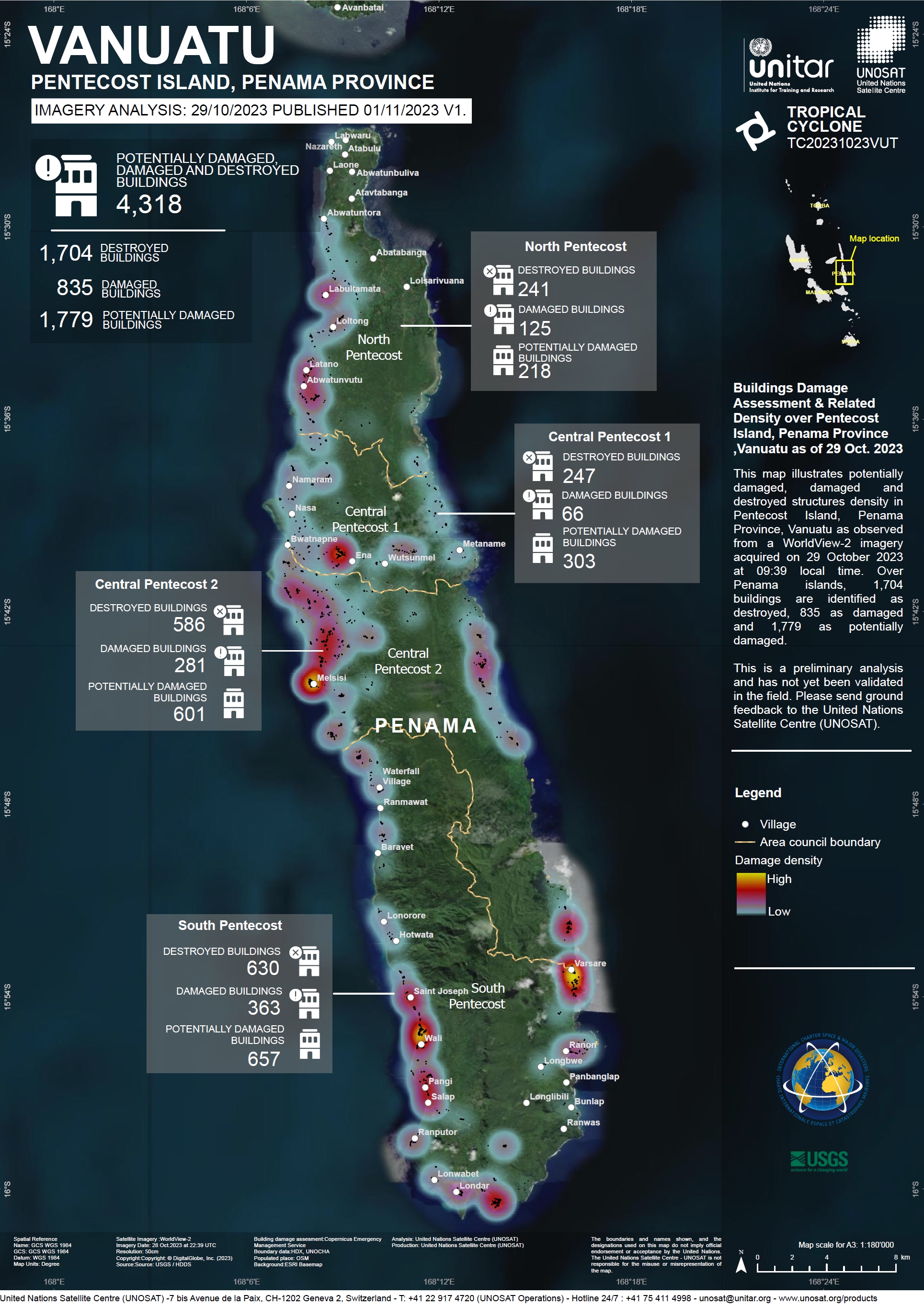
Damage Assessment of Buildings on Pentecost Island, Penama Province, Vanuatu
Copyright: WorldView-2 © (2023) DigitalGlobe, Inc., Longmont CO USA 80503.
DigitalGlobe and the DigitalGlobe logos are trademarks of DigitalGlobe, Inc. The use and/or dissemination of this data and/or of any product in any way derived there from are restricted. Unauthorized use and/or dissemination is prohibited.
Map produced by UNITAR/UNOSAT.
Information about the Product
Acquired: 28/10/2023
Source: WorldView-2
Category: Reference Map
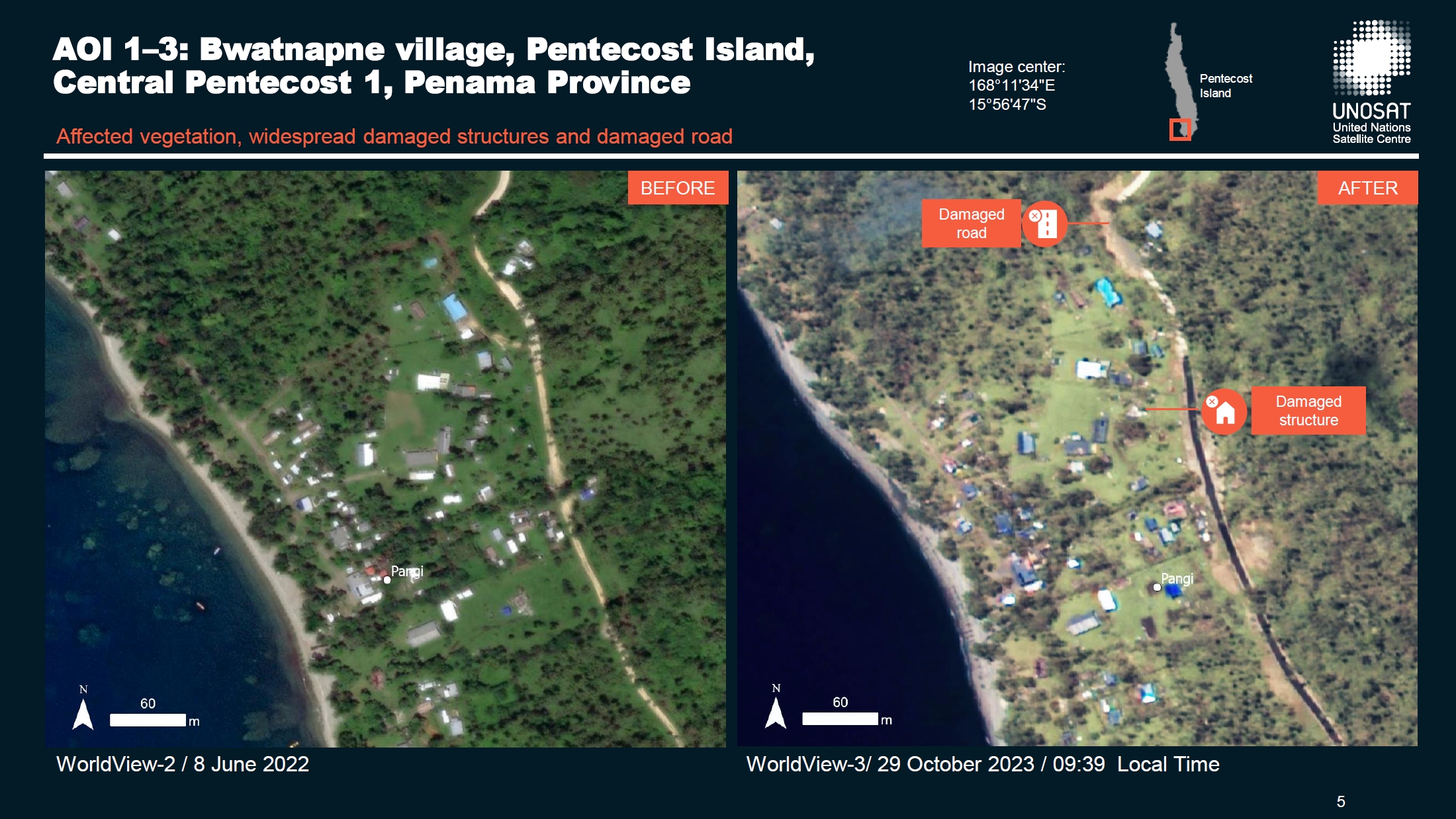
Preliminary Satellite Agricultural Damage Assessment of Ambrym Island in the Malampa Province and the Pentecost Islands in the Penama Province, Vanuatu
Download the Full Report
Copyright: WorldView-2 and WorldView-3 © (2023) DigitalGlobe, Inc., Longmont CO USA 80503.
DigitalGlobe and the DigitalGlobe logos are trademarks of DigitalGlobe, Inc. The use and/or dissemination of this data and/or of any product in any way derived there from are restricted. Unauthorized use and/or dissemination is prohibited.
Report produced by UNITAR/UNOSAT.
Information about the Product
Acquired: WorldView-2: 28/05/2022 and 08/06/2022
WorldView-3: 29/10/2023
Source: WorldView-2 and WorldView-3
Category: Reference Map
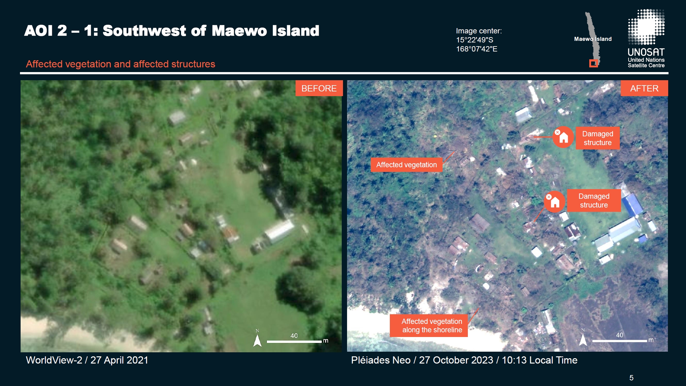
Preliminary Satellite Agricultural Damage Assessment of the Ambae and Maewo Islands, Penama Province, Vanuatu
Download the Full Report
Copyright: WorldView © (2023) DigitalGlobe, Inc., Longmont CO USA 80503.
DigitalGlobe and the DigitalGlobe logos are trademarks of DigitalGlobe, Inc. The use and/or dissemination of this data and/or of any product in any way derived there from are restricted. Unauthorized use and/or dissemination is prohibited.
Includes Pleiades material © CNES (2023), Distribution Airbus DS.
Report produced by UNITAR/UNOSAT.
Information about the Product
Acquired: WorldView-2: 27/04/2021
Pleiades: 26/10/2023 and 27/10/2023
Source: WorldView-2 and Pleiades
Category: Dossier
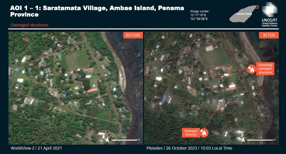
Tropical Cyclone Lola-23, Preliminary satellite-derived damage assessment, Penama Province, Vanuatu
Download the full report
Copyright: Includes Pleiades material © CNES (2023), Distribution Airbus DS.
Report produced by UNITAR/UNOSAT.
Information about the Product
Acquired: 25/10/2023
Source: Pleiades
Category: Dossier
 Back to the full activation archive

