 English
 Spanish
 French
 Chinese
 Russian
 Portuguese
 Последняя Активация
Charter activations
Flooding in Chile
Days of heavy rainfall swelled Chile's rivers, causing deadly widespread floods as the country sees the worst weather front in a decade.
The deluge blocked roads, prompted an evacuation in the centre of the country and a red alert has been issued by The Meteorological Directorate of Chile in some regions, warning of further heavy rains and the possibility of landslides.
The rains come just a few months after a period of wildfires amid a severe drought that destroyed hundreds of homes and left dozens of people dead.
| Тип события: | Floods |
| Место события: | Chile |
| Date of Charter Activation: | 2023-06-28 |
| Время активации Хартии: | 15:21 |
| TЧасовой пояс в районе активации Хартии: | UTC-04:00 |
| Запрос на активацию поступил от: | Ministry of Interior and Public Safety (ONEMI) |
| Номер активации: | 826 |
| Менеждер проекта от: | Marcelo Duran (Natural Resources Information Center (CIREN)) |
Products
Areas affected by Flooding and Landslides in the O'Higgins Region, El Guapi, Chile
Авторские права: © DLR e.V. (2010), Distribution Airbus DS Geo GmbH.
Map produced by the Natural Resources Information Centre (CIREN).
Information about the Product
Получено: 12/03/2023, 27/06/2023, 30/06/2023, 05/07/2023
Источник: TerraSAR-X
Категория: Delineation Map
Areas affected by Flooding and Landslides in the BioBio Region, Concepcion, Chile
Авторские права: RADARSAT-2 Data and Products © Maxar Technologies Ltd. (2023) – All Rights Reserved.
RADARSAT is an official mark of the Canadian Space Agency.
Map produced by the Natural Resources Information Centre (CIREN).
Information about the Product
Получено: 22/07/2023
Источник: RADARSAT-2
Категория: Delineation Map
Areas affected by Flooding and Landslides in the Ñuble Region, Treguaco, Chile
Авторские права: Includes Pleiades material © CNES (2023), Distribution Airbus DS.
Map produced by the Natural Resources Information Centre (CIREN).
Information about the Product
Получено: 08/07/2023
Источник: Pleiades
Категория: Delineation Map
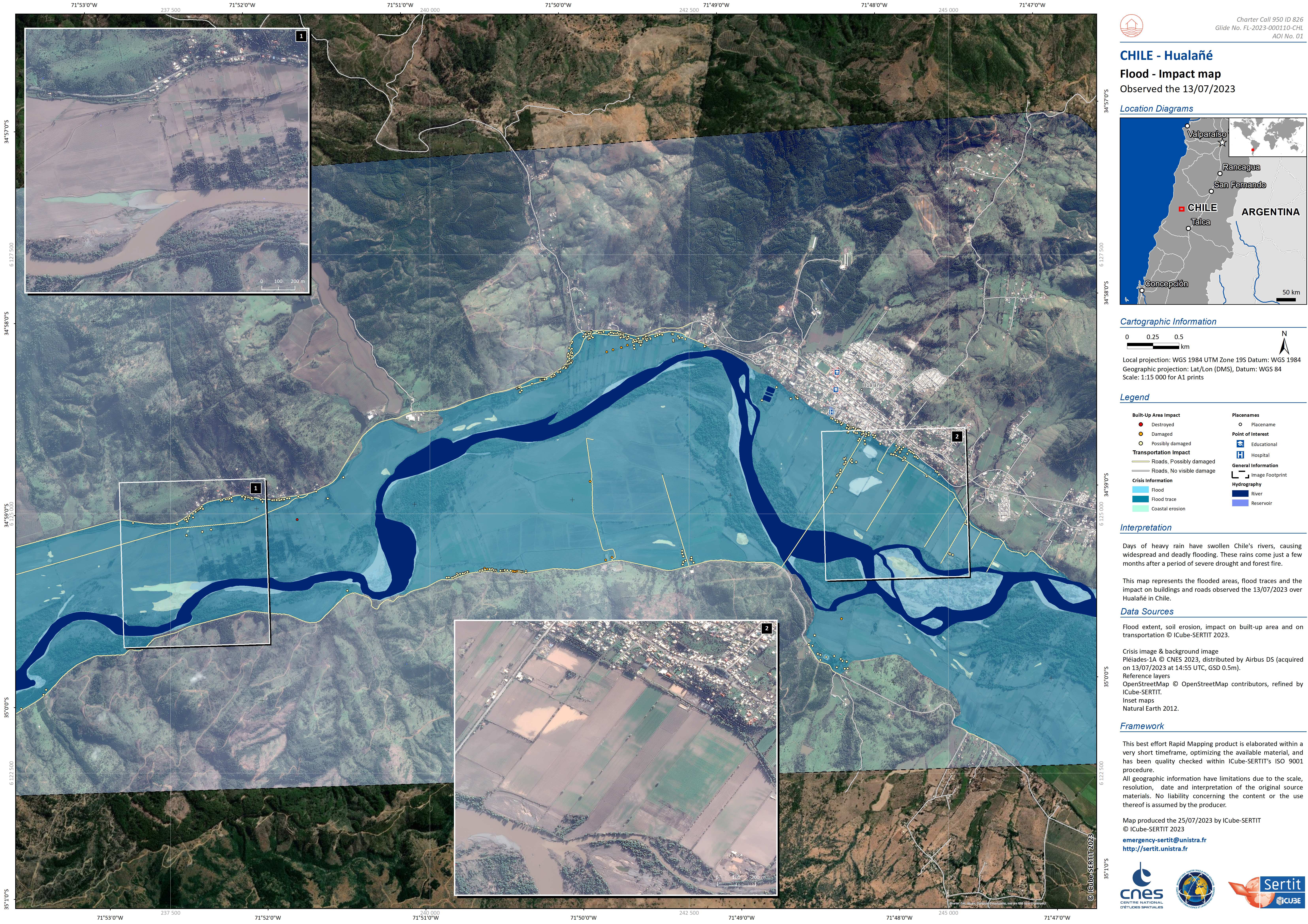
Areas affected by Flooding and Landslides in the Maule Region, Hualane, Chile
Авторские права: Includes Pleiades material © CNES (2023), Distribution Airbus DS.
Map produced by the Natural Resources Information Centre (CIREN).
Information about the Product
Получено: 06/07/2023
Источник: Pleiades
Категория: Delineation Map
Areas affected by Flooding and Landslides in the city of Las Cabras in the O'Higgins Region, Chile
Авторские права: © Planet Labs Inc. (2023)
Map produced by the Natural Resources Information Centre (CIREN).
Information about the Product
Получено: 05/07/2023
Источник: PlanetScope
Категория: Delineation Map
Areas affected by Flooding and Landslides in the city of Doñihue in the O'Higgins Region, Chile
Авторские права: © Planet Labs Inc. (2023)
Map produced by the Natural Resources Information Centre (CIREN).
Information about the Product
Получено: 05/07/2023
Источник: PlanetScope
Категория: Delineation Map
Areas affected by Flooding and Landslides in the Talhuenes area of the Maule Region, Chile
Авторские права: Contains modified Copernicus Sentinel data (2023)
Map produced by the Natural Resources Information Centre (CIREN).
Information about the Product
Получено: 29/06/2023
Источник: Sentinel-2
Категория: Delineation Map
Areas affected by Flooding and Landslides in the Ñuble Region, Ñiquen, Chile
Авторские права: Contains modified Copernicus Sentinel data (2023)
Map produced by the Natural Resources Information Centre (CIREN).
Information about the Product
Получено: 29/06/2023
Источник: Sentinel-2
Категория: Delineation Map
Areas affected by Flooding and Landslides in the O'Higgins Region of Chile
Авторские права: Contains modified Copernicus Sentinel data (2023)
Map produced by the Natural Resources Information Centre (CIREN).
Information about the Product
Получено: 26/06/2023
Источник: Sentinel-1
Категория: Delineation Map
Areas affected by Flooding and Landslides in the Metropolitana Region of Chile
Авторские права: Contains modified Copernicus Sentinel data (2023)
Map produced by the Natural Resources Information Centre (CIREN).
Information about the Product
Получено: 26/06/2023
Источник: Sentinel-1
Категория: Delineation Map
Areas affected by Flooding and Landslides in the BioBio Region, Chile
Авторские права: Contains modified Copernicus Sentinel data (2023)
Map produced by the Natural Resources Information Centre (CIREN).
Information about the Product
Получено: 26/06/2023
Источник: Sentinel-1
Категория: Delineation Map
Areas affected by Flooding and Landslides in the Ñuble Region of Chile
Авторские права: Contains modified Copernicus Sentinel data (2023)
Map produced by the Natural Resources Information Centre (CIREN).
Information about the Product
Получено: 26/06/2023
Источник: Sentinel-1
Категория: Delineation Map
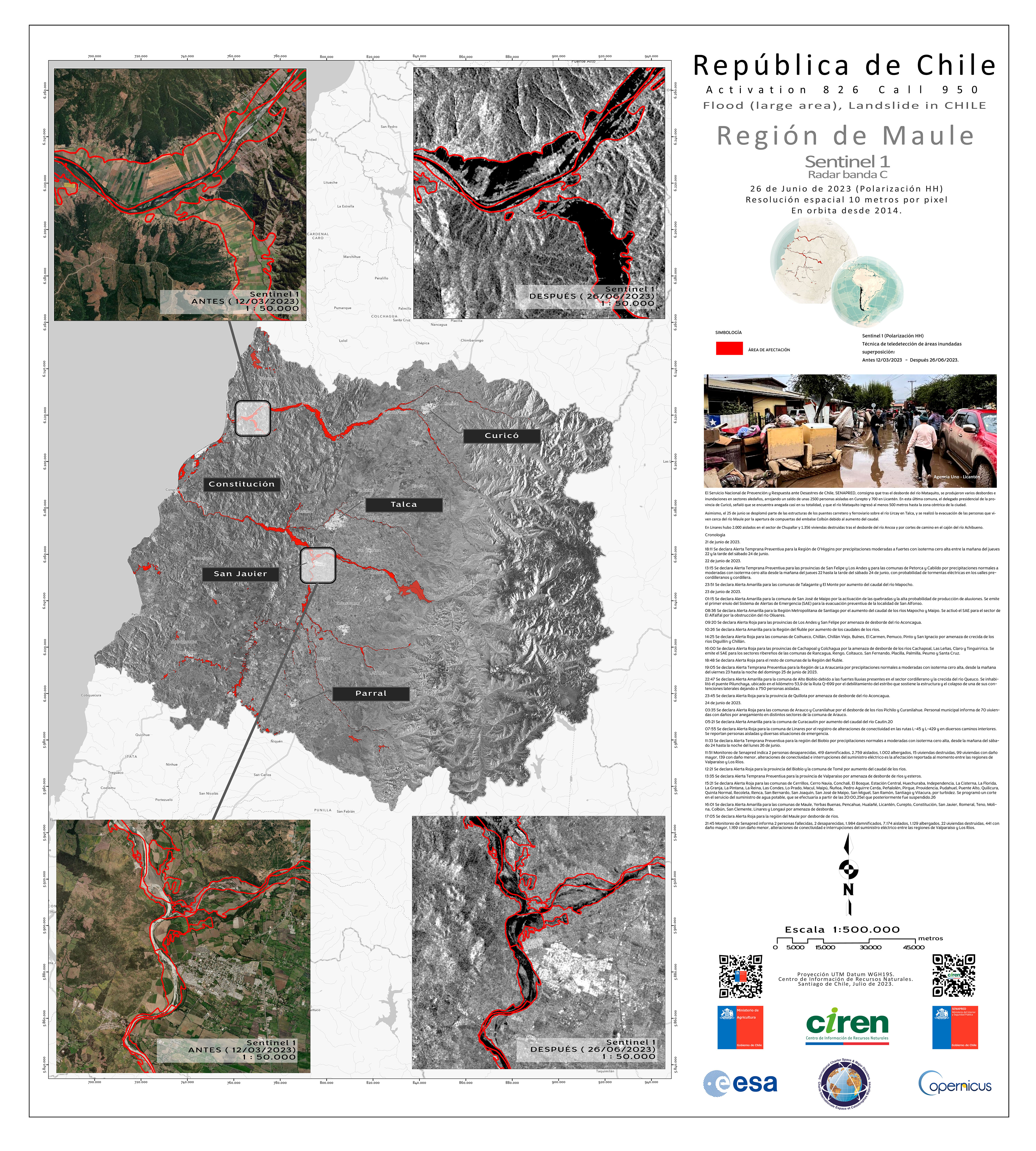
Areas affected by Flooding and Landslides in the Maule Region, Chile
Авторские права: Contains modified Copernicus Sentinel data (2023)
Map produced by the Natural Resources Information Centre (CIREN).
Information about the Product
Получено: 26/06/2023
Источник: Sentinel-1
Категория: Delineation Map
 Вернуться к полному архиву активаций

