 English
 Spanish
 French
 Chinese
 Russian
 Portuguese
 Последняя Активация
Charter activations
Flood in Bangladesh
Sixteen people have died in floods affecting Bangladesh.
An estimated 1.5 million people have been affected by the floods, which follow days of heavy rainfall in the region.
The torrential rain has affected several other countries in the region and caused rivers such as the Brahmaputra, which passes through Bangladesh, to flood. The Brahmaputra, Ganges (locally known as Padma) and Meghna Rivers - three of the largest in Asia - all meet in Bangladesh and form the Bengal Delta, which means that flood waters are travelling down-river towards Bangladesh. The Jamuna, Surma, Kushiyara and Dharla Rivers all reached dangerously high water levels, inundating inhabited areas in the country. There are also concerns that the Ganges may rise, contributing to floods in Rajbari, Manikganj, Munshiganj and Shariatpur districts.
The water levels in the major rivers are expected to begin receding over the next few days and forecasters expect little rain for Bangladesh during that time.
Despite the potential for an improved situation, it is estimated that thousands of homes and hundreds of villages have been flooded. Hundreds of people have also been left isolated by the floods, and road and railway lines have been blocked in some locations.
The government has established 70 evacuation shelters for those affected by the disaster, but many other areas are still facing difficulties in obtaining clean water and food. The flood waters have also damaged crops, particularly Aman rice seed-beds.
While the flooding began in the north-east of the country, it is now spreading toward the central and southern areas of Bangladesh, flowing along rivers and downhill.
| Тип события: | Flood |
| Место события: | Bangladesh |
| Date of Charter Activation: | 1 August 2016 |
| Время активации Хартии: | 10:05:00 |
| TЧасовой пояс в районе активации Хартии: | UTC+09:00 |
| Запрос на активацию поступил от: | ADRC on behalf of SPARRSO |
| Менеждер проекта от: | Asian Institute of Technology (AIT) |
Products
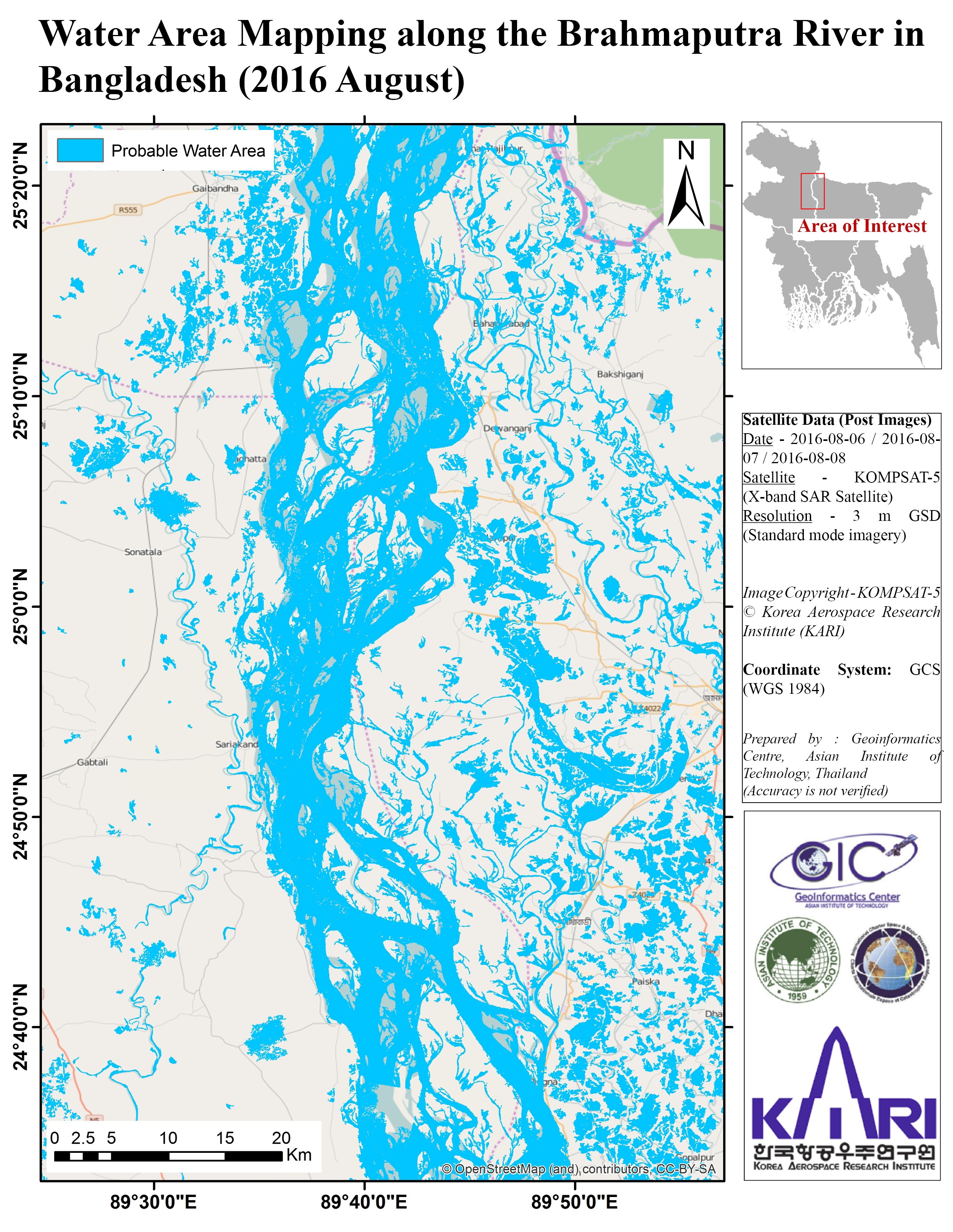
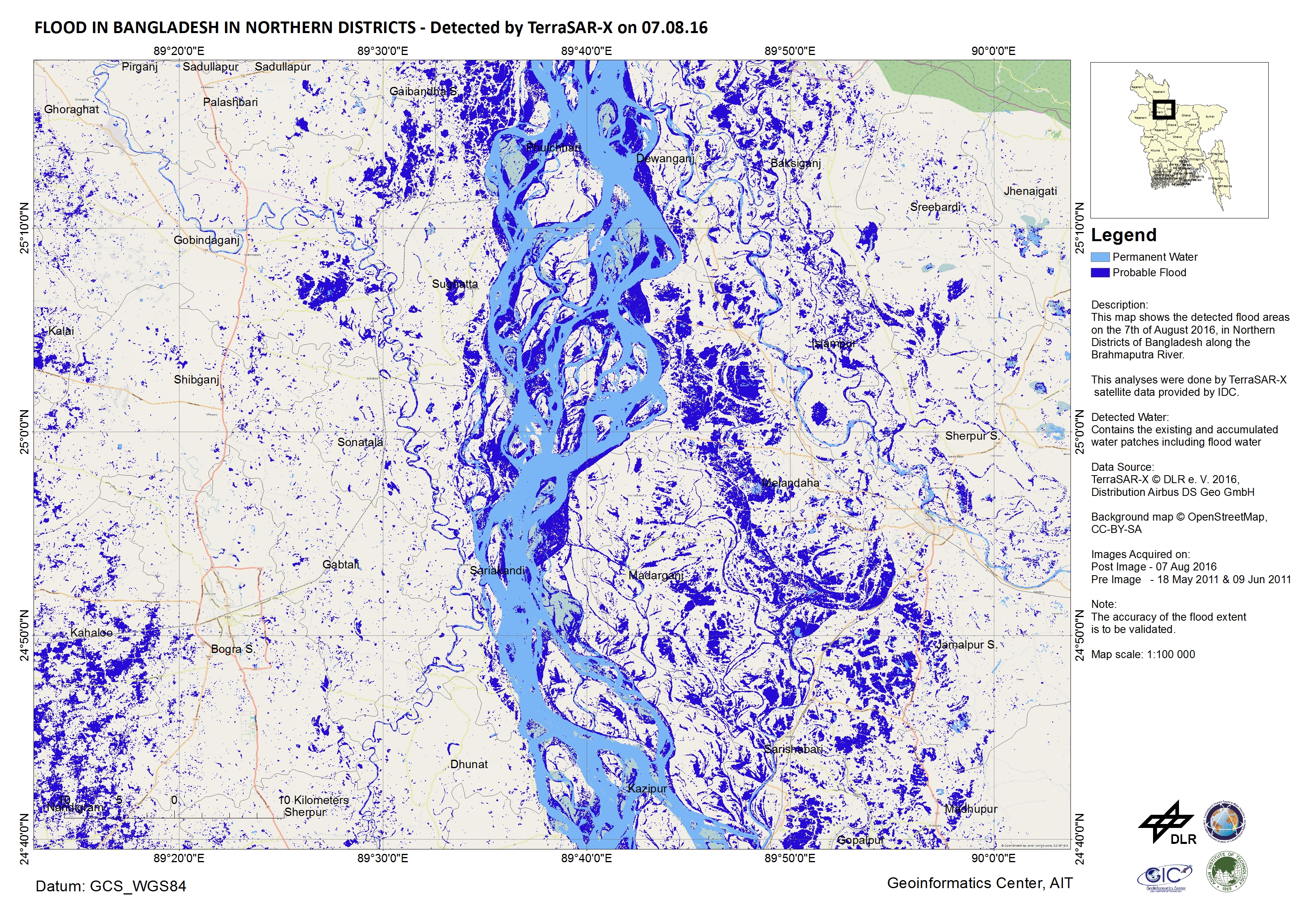
Flood waters in northern districts, Bangladesh
Авторские права: DLR e. V. 2016, Distribution: Airbus DS Geo GmbH
Map produced by Geoinformatics Center, Asian Institute of Technology
Information about the Product
Получено: Pre-disaster: 18/05/2011 and 09/06/2011
Post-disaster: 07/08/2016
Источник: TerraSAR-X
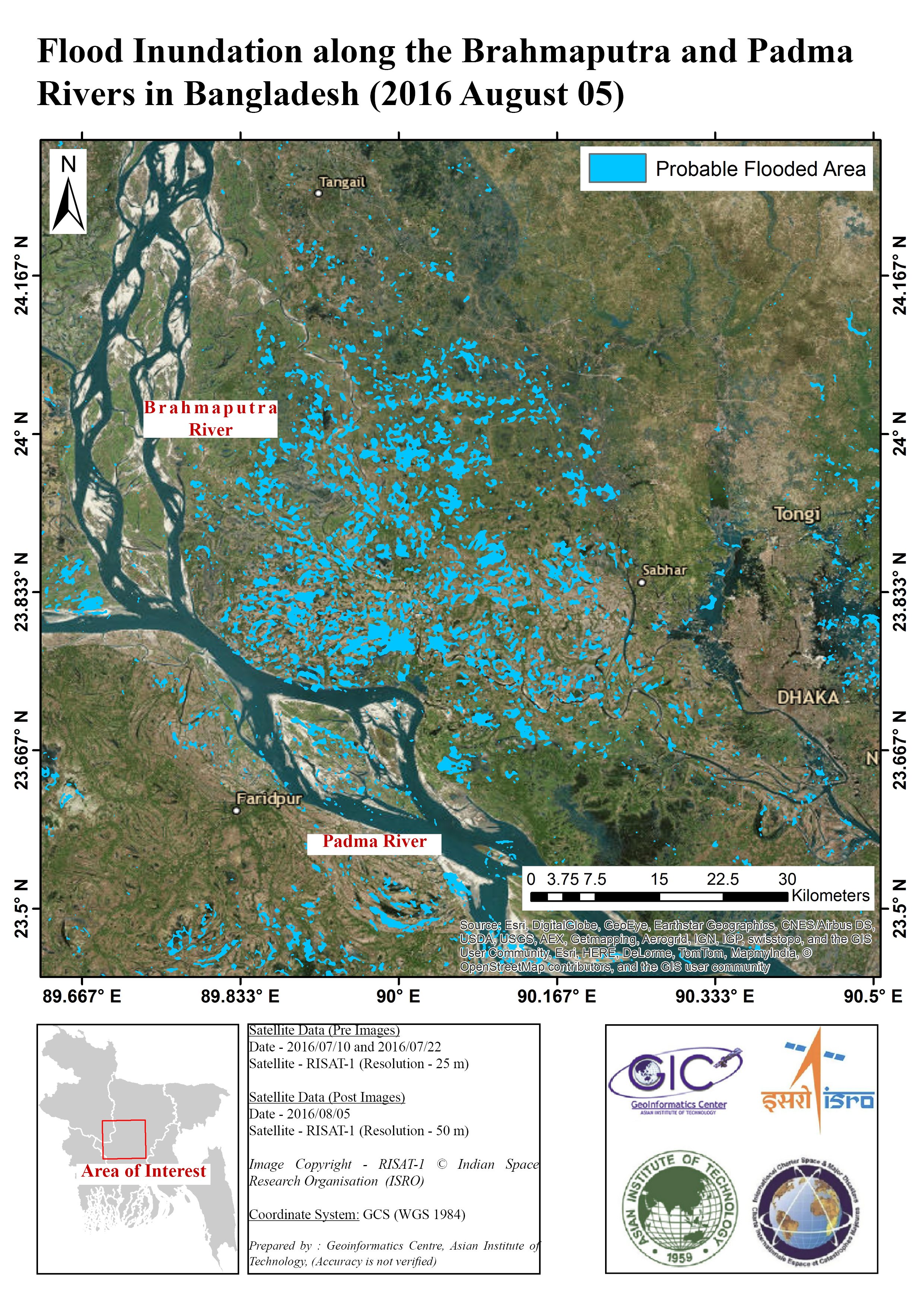
Flooding along the Brahmaputra and Padma Rivers, Bangladesh
Авторские права: ISRO (2016) - All rights reserved
Map produced by Geoinformatics Center, Asian Institute of Technology
Information about the Product
Получено: Pre-disaster: 10/07/2016 and 22/07/2016
Post-disaster: 05/08/2016
Источник: RISAT-1
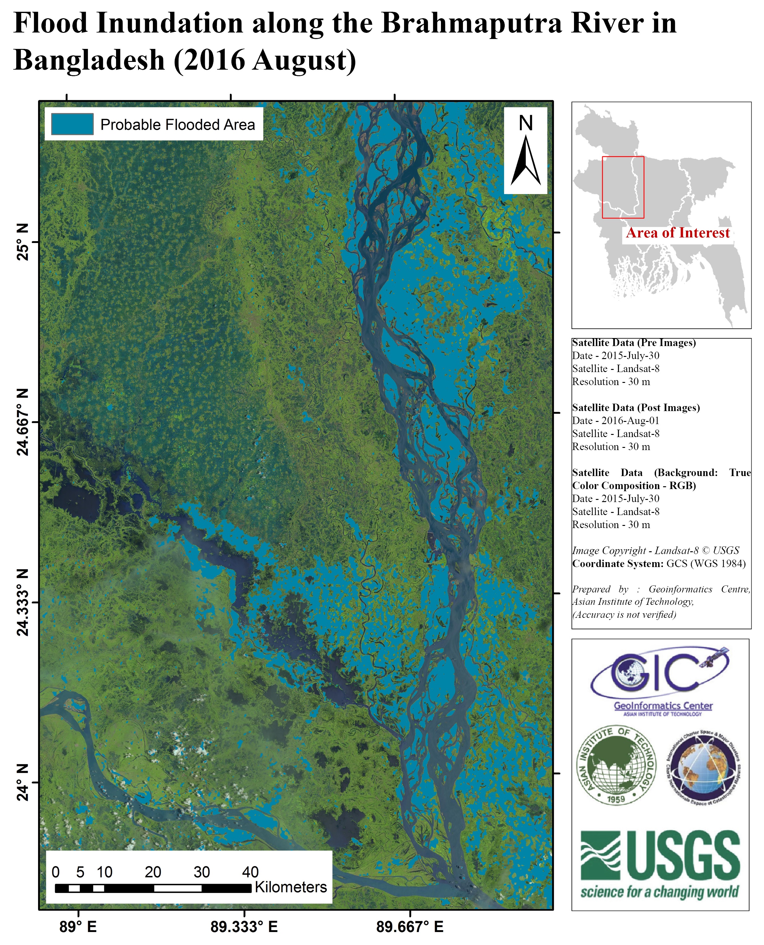
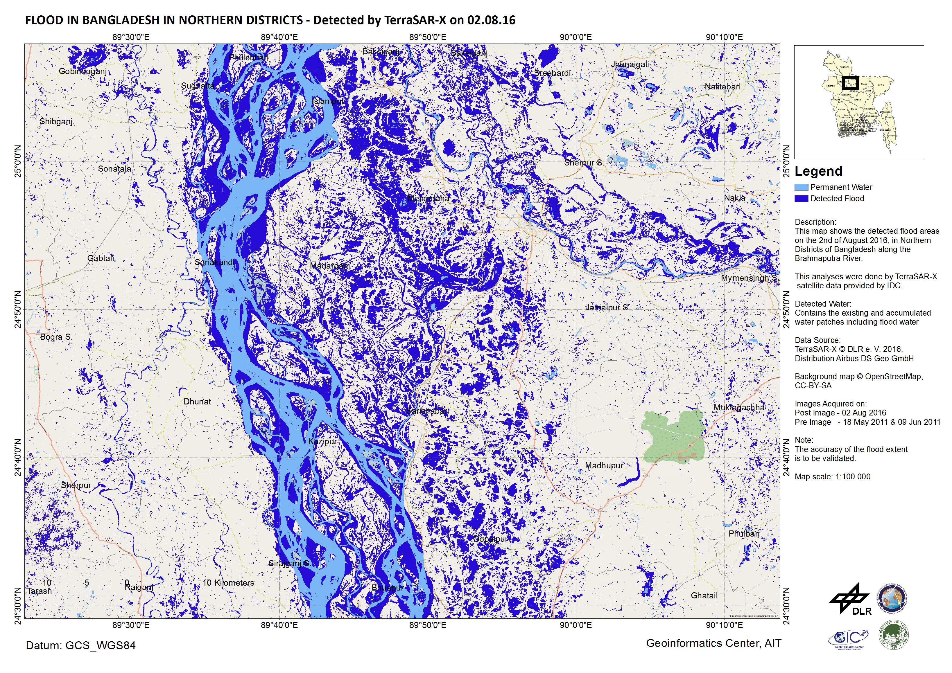
Flood in northern districts of Bangladesh
Авторские права: DLR e. V. 2016, Distribution: Airbus DS Geo GmbH
Map produced by Geoinformatics Center, Asian Institute of Technology
Information about the Product
Получено: Pre-disaster: 18/05/2011 and 09/06/2011
Post-disaster: 02/08/2016
Источник: TerraSAR-X
 Вернуться к полному архиву активаций

