 English
 Spanish
 French
 Chinese
 Russian
 Portuguese
 Latest Activation
Charter activations
Typhoon Khanun in Russia
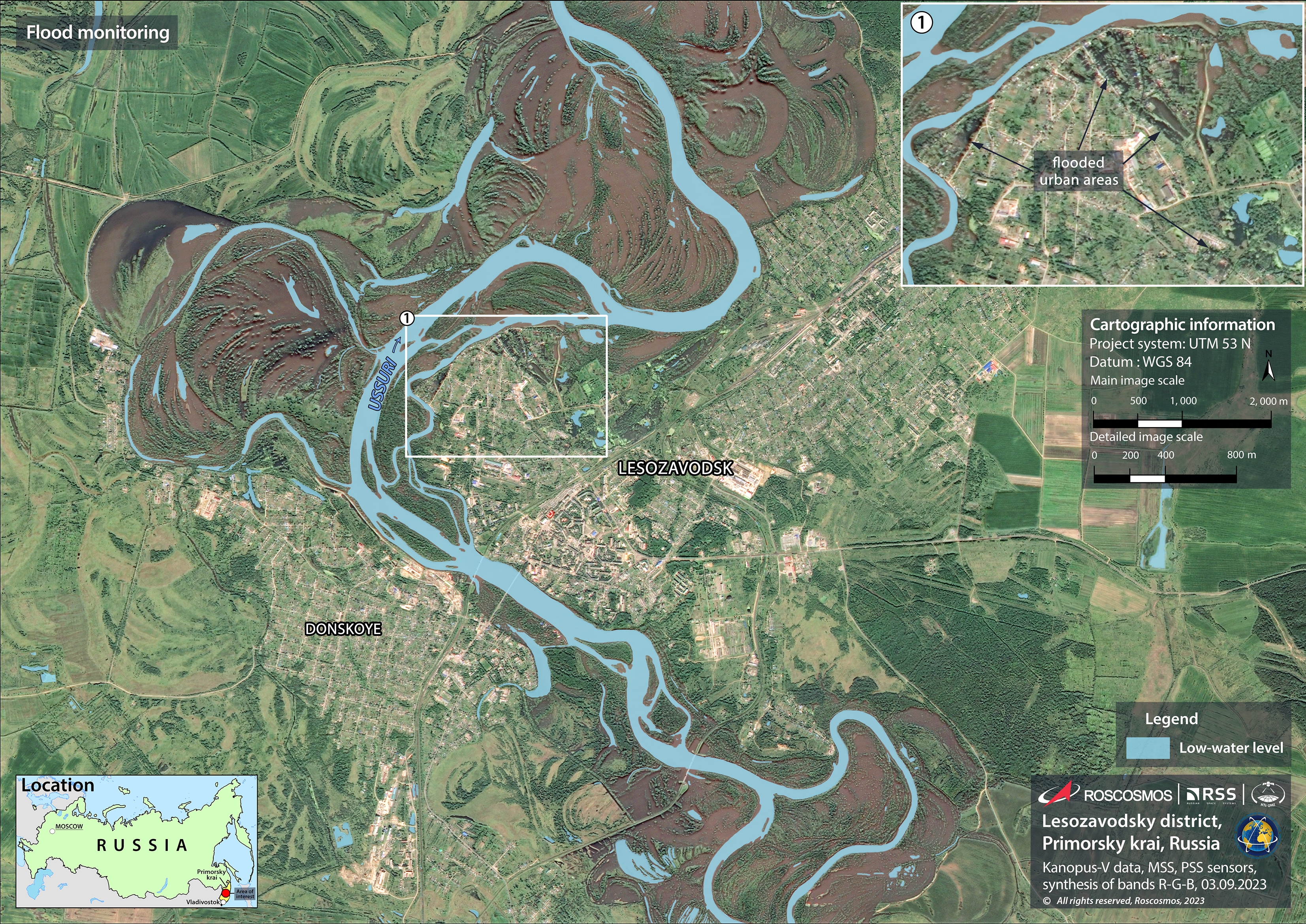
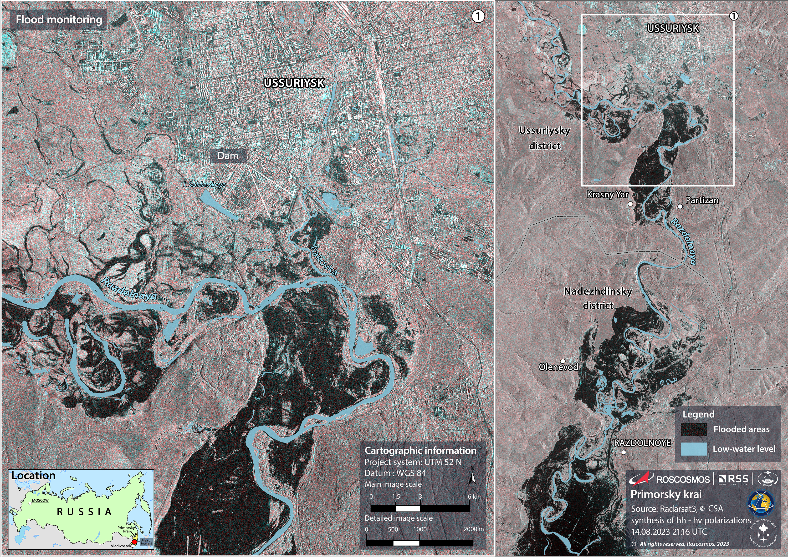
Tropical storm Khanun brought heavy rainfall which led to flooding in parts of the Primorye region in Russia's Far East at the start of August. More than 2,000 people, including 405 children, were evacuated from inundated areas.
The town of Ussuriysk, located some 75 kilometers from Primorye's capital Vladivostok, was badly affected and a dam that was necessary for holding back flood waters burst. Approximately 35-40% of Ussuriysk's territory was affected making this flood the worst in a decade.
28 settlements were cut off by stagnant water and over 4,300 residential buildings were flooded. 16 of the region's districts were affected but no casualties were reported.
A task force was sent to the Primorye region after the Typhoon had passed through to oversee a cleanup operation.
Tropical storm Khanun previously had swept over the Korean Peninsula, which borders the Primorye region, after travelling over Japan and China.
| Tipo de evento: | Floods |
| Local do evento: | Russian Federation |
| Data da Ativação da Carta: | 2023-08-14 |
| Tempo de Ativação da Carta: | 12:31 |
| Zona de Tempo da Ativação da Carta: | UTC+03:00 |
| Requisitante da Carta: | Ministry of the Russian Federation for Civil Defense, Emergencies and Elimination of Natural Disasters (EMERCOM) |
| ID da Ativação: | 835 |
| Gerenciamento de projeto: | Andrey Kuklin (ROSCOSMOS) |
| act-value-adders: | Georgy Korolyov (EMERCOM of Russia) |
Products
Flood Monitoring after Typhoon Khanun in Ussuriysk, Russia
Direitos autorais: RADARSAT Constellation Mission Imagery © Government of Canada (2023) - RADARSAT is an official mark of the Canadian Space Agency.
Map produced by ROSCOSMOS - The Russian Space Agency.
Information about the Product
Adquirida: 14/08/2023
Fonte: RCM
Categoria: Delineation Map
Quickviews
Quickviews are produced for illustration purposes only and do not contain any verified analysis of the disaster.


Radar images highlighting the extent of flooding caused by Typhoon Khanun in the Primorye region of eastern Russia. In the post-event image (left), the black shading to the right hand side indicates areas submerged by water.
Copyrights: RADARSAT Constellation Mission (RCM) Imagery © Government of Canada (2023) - RADARSAT is an official mark of the Canadian Space Agency.
SAOCOM Imagery © CONAE (2023).
Information about the Quickview
Acquired: 2023-08-15 / 2023-07-20
Source(s): RCM / SAOCOM
 Voltar ao arquivo completo da Ativação

