 English
 Spanish
 French
 Chinese
 Russian
 Portuguese
 最新宪章启动
Charter activations
西非洪灾
8月底至9月初的暴雨导致西非发生大面积洪灾。西非11个国家(马里、布基纳法索、毛里塔尼亚、尼日尔、科特迪瓦、塞内加尔、冈比亚、利比里亚、多哥、塞拉利昂和加纳)的50万人口受灾。
加纳的情况尤为严重,约有26万人受灾;布基纳法索有3.5万人受灾,多哥有20389人受灾。截至目前,加纳、布基纳法索和毛里塔尼亚已经请求国际援助或支持。
| 事件类型: | 洪灾 |
| 事件地点: | 西非 |
| 启动宪章的日期: | 2007年9月14日 |
| 宪章要求者: | UNOOSA代表UNOCHA |
| 项目经理: | UNOSAT |
Products
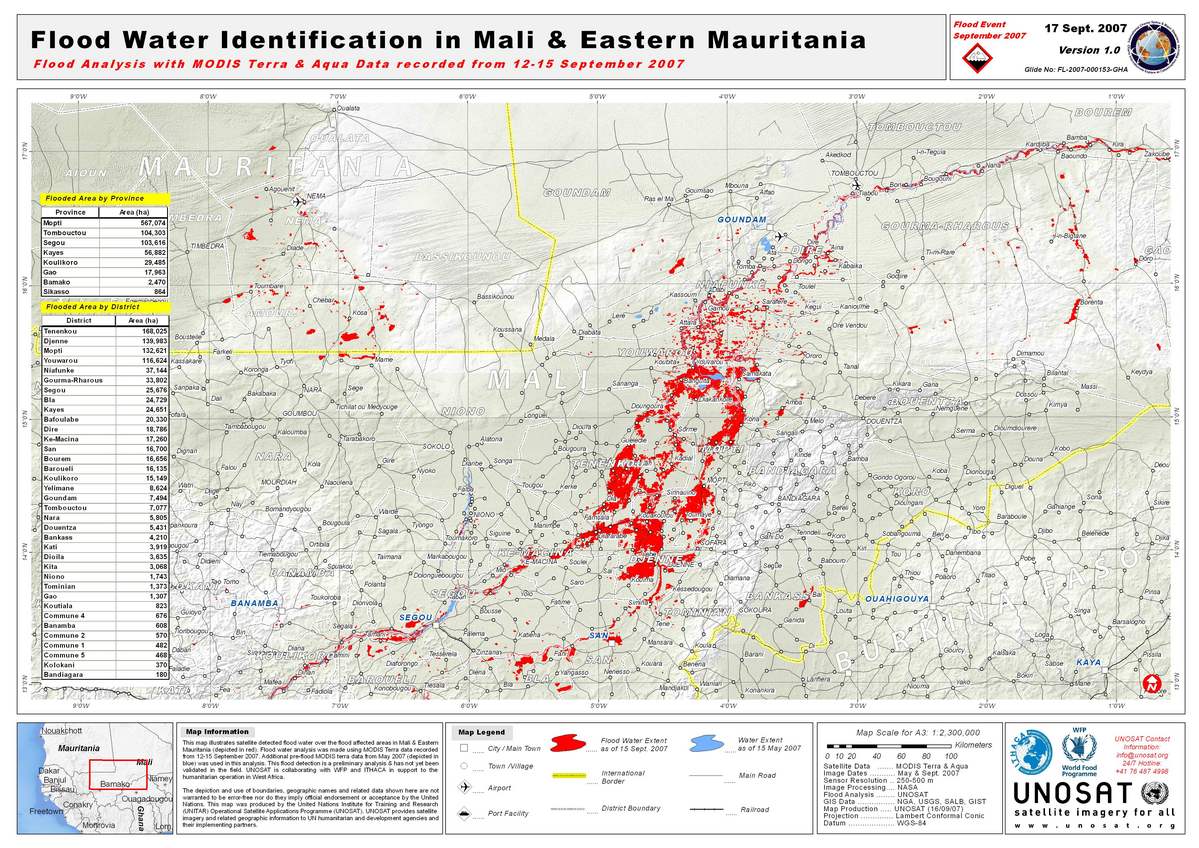
Mali Flood Map 17/09/2007
版权: NASA 2007 Image processing
Map created 17/09/2007 by UNOSAT
Information about the Product
已获得: 12-15/09/2007 and 05/2007 Satellite-detected flood water over the flood affected areas in Mali and eastern Mauritania (red). Flood water analysis was made using MODIS Terra data recorded from 12-15 September 2007, with additional pre-flood MODIS terra data from May 2007 (blue). Preliminary analysis not yet validated in the field.
源: MODIS Terra and Aqua, 250-500m/pixel resolution
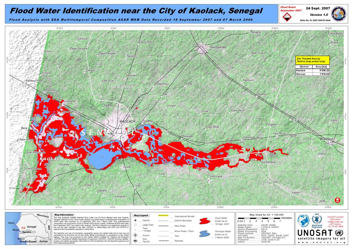
Envisat ASAR, Floods in Senegal
版权: ESA 2006, 2007; credit NASA 2007 Image processing, map created 21/09/2007 by UNOSAT.
Information about the Product
已获得: 07/03/2006 and 18/09/2007 Satellite-detected flood water over the flood-affected area near Kaolack, Senegal (in red). Flood water analysis was made using a multitemporal composition of ASAR radar data recorded on 18 September 2007 and 7 March 2006. The multitemporal composition was produced by ESA on behalf of the Space Charter. Additional MODIS terra data from September 2007 was used in this analysis. Preliminary analysis not yet validated in the field.
源: Envisat ASAR WSM; MODIS on Terra, 150m/pixel resolution.
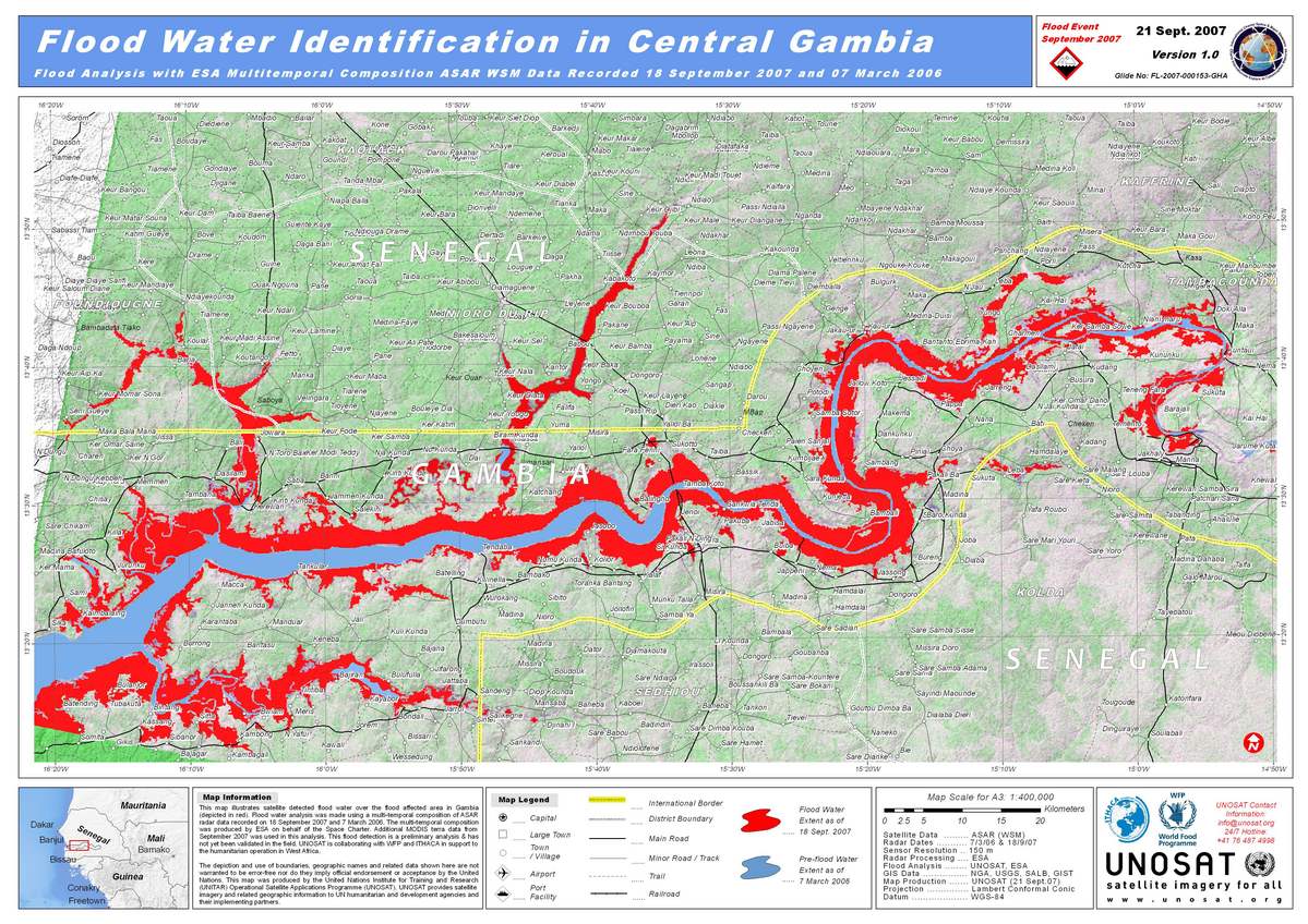
Envisat ASAR, Floods in Gambia
版权: ESA 2006, 2007; credit NASA 2007 Image processing, map created 21/09/2007 by UNOSAT.
Information about the Product
已获得: 07/03/2006 and 18/09/2007 Satellite-detected flood water over the flood-affected area in Gambia (in red). Flood water analysis was made using a multitemporal composition of ASAR radar data recorded on 18 September 2007 and 7 March 2006. The multitemporal composition was produced by ESA on behalf of the Space Charter. Additional MODIS Terra data from September 2007 was used in this analysis. Preliminary analysis not yet validated in the field.
源: Envisat ASAR WSM; MODIS on Terra, 150m/pixel resolution.
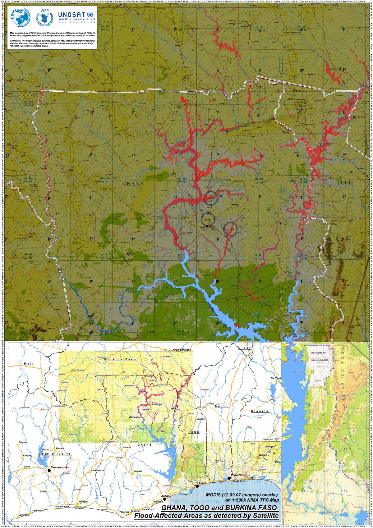
MODIS Overlay, Floods in Ghana, Togo, and Burkina
版权: NASA 2007 Image processing, map created 14/09/2007 by WFP ODAP.
Information about the Product
已获得: 12-14/09/2007 Satellite-detected flood water over the flood affected area over Ghana, Togo and Burkina Faso (red). Total population figures estimated by province and district admin. units (levels 1 and 2). Preliminary analysis not yet validated in the field.
源: MODIS on Aqua and Terra, 250-500m/pixel resolution.
 返回完整的响应档案

