 English
 Spanish
 French
 Chinese
 Russian
 Portuguese
 最新宪章启动
Charter activations
海地飓风马修
飓风马修是近年来最强大的大西洋飓风之一,目前正在肆虐加勒比地区,造成了严重破坏。飓风在海地已经夺走了170多人的生命,受灾人数达数万人。
10月4日,第四类风暴马修在海地西海岸附近的Les Anglais附近登陆。它带来了风速超过230公里/小时(145英里/小时)的强风和大雨,并引发了洪涝。数以万计的房屋被摧毁,一些村镇被彻底冲毁。成千上万的群众无家可归,正在搭起帐篷和救援中心为许多幸存者服务,据报道,有数百人在附近的洞穴中寻求庇护,同时等待援助的到来。据估计,有一百多万人受到了影响。
在连接该地区到首都太子港的拉迪格桥在风暴中崩塌后,海地南部也陷入了孤立状态。据报道,全国南部地区的莱凯港遭受了"灾难性"的破坏,有7万人的整个城镇被洪水淹没。当主要通路被切断时,南部地区受影响的人员何时可以从该国其他地方获得援助尚未可知。
灾难之后,饥荒也引起了额外的关注。许多作物被飓风马修摧毁,海地临时总统表示,除非情况发生变化,否则该国可能在未来几个月内将面临饥荒。
自马修袭击该岛以来,随着风暴的侵袭,霍乱病例呈上升趋势,已报告有二百多人染上了霍乱。医生担心如果没有足够的疫苗和清洁水供应,可能会出现疫情。
这场灾难已被描述为海地自2010年发生的毁灭性地震以来遭受的最严重的灾难,这个岛屿国家目前仍在恢复中。
飓风马修对加勒比地区的16个国家造成了影响。当海地遭受最严重损失的时候,飓风也影响到邻近的多米尼加共和国,并向北移动,影响到古巴、巴哈马和美国。
| 事件类型: | 海洋风暴 - 飓风 |
| 事件地点: | 海地 |
| 启动宪章的日期: | 2016年10月03日 |
| 宪章启动时间: | 22:00:00 |
| 宪章启动时区: | UTC+02:00 |
| 宪章要求者: | 美国地质调查局(USGS)代表太平洋灾害中心-跨部门应急指挥中心/-UNITAR(联合国调查训练研究所)- UNOSAT(联合国卫星应用计划训练与研究营运中心)代表联合国人道事务协调厅(UNOCHA) |
| 项目经理: | 太平洋灾害中心 |
Products
Preliminary damage assessment report of Grand Anse, South and Nippes in Haiti
Download the full report
版权: Report produced by UNITAR/UNOSAT
Information about the Product
已获得: Pre-disaster: 08/12/2014, 28/11/2014, 01/05/2015, 09/05/2015, 14/06/2015, 16/06/2015, 17/10/2015, 17/07/2016
Post-disaster: 07/10/2016, 09/10/2016, 12/10/2016, 17/10/2016, 09/11/2016
源: Pleiades / WorldView-1, -2 and -3

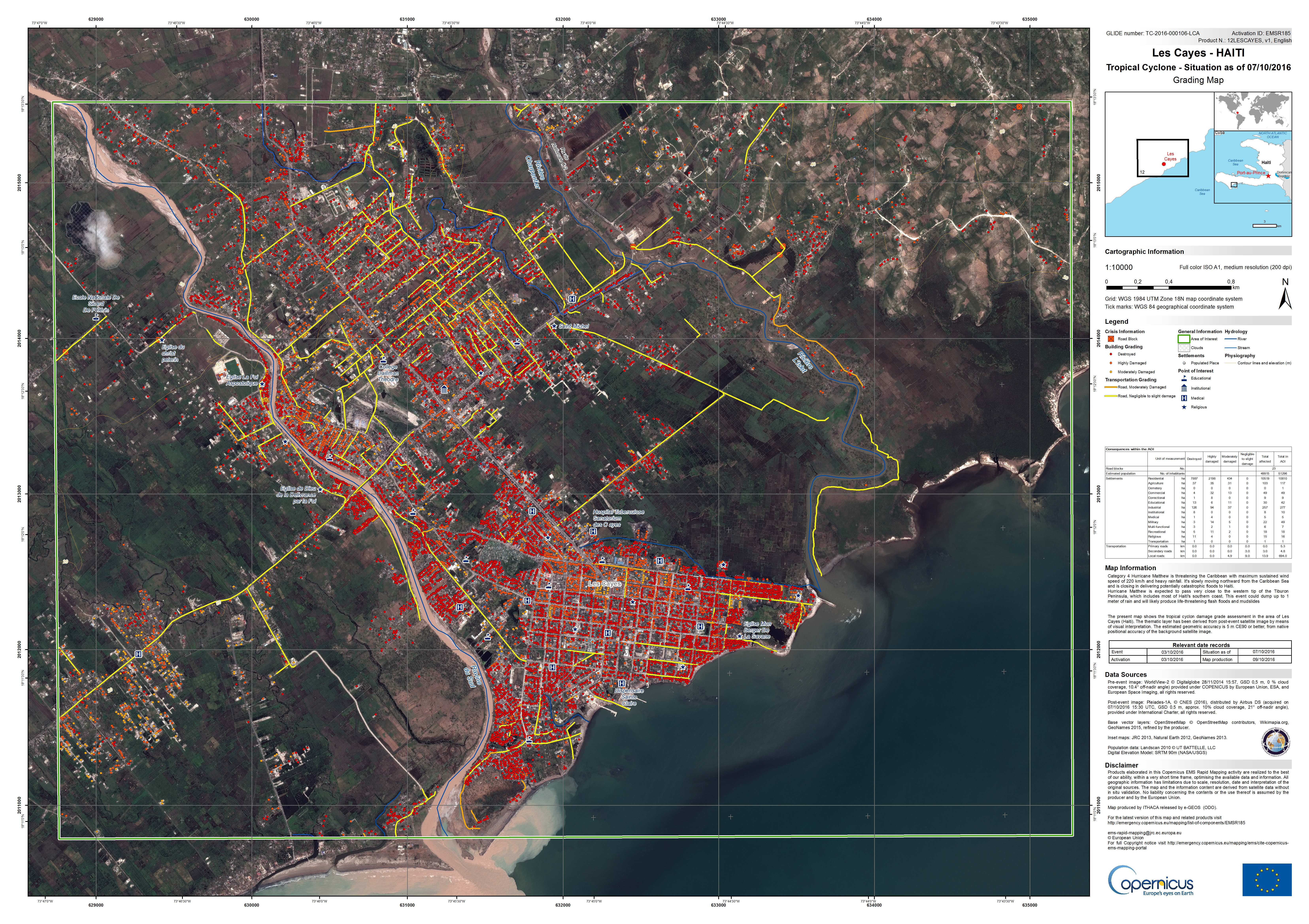
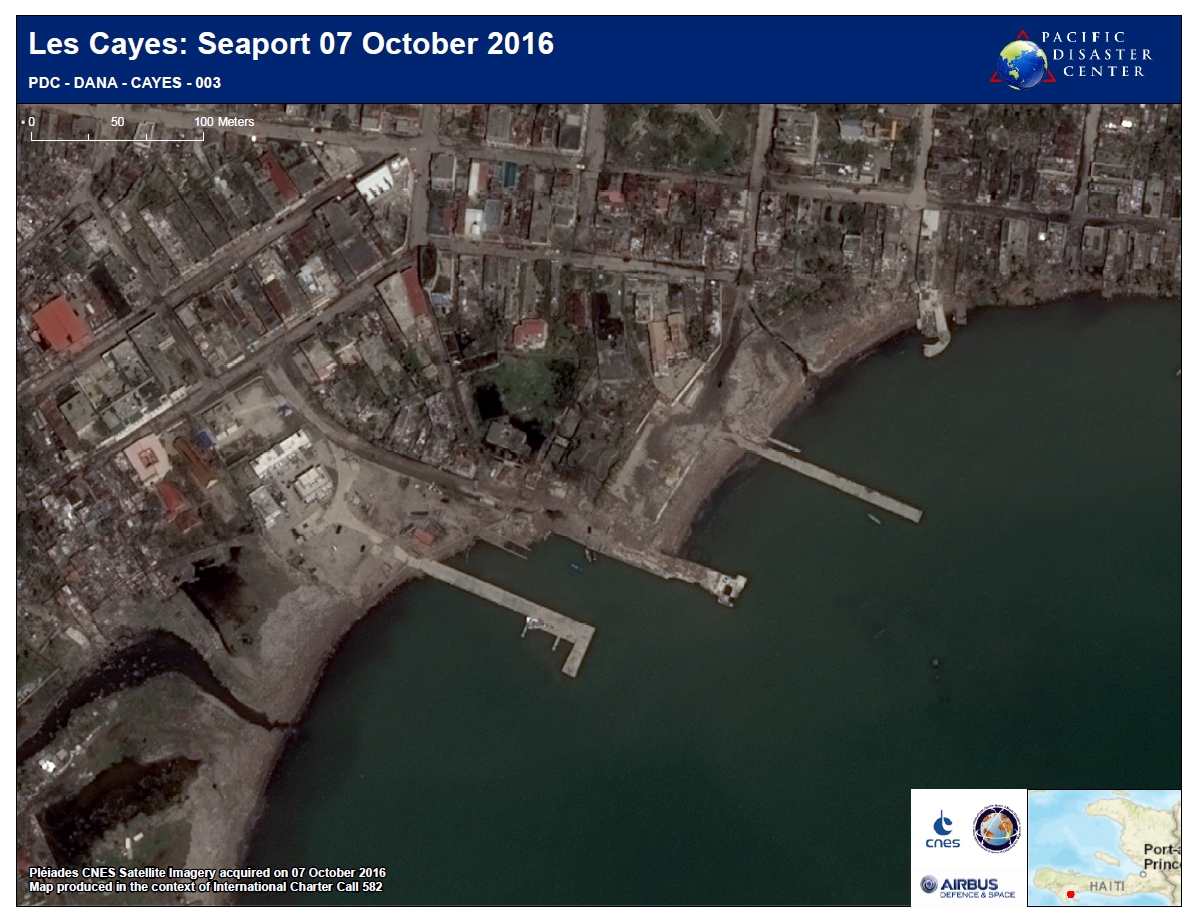
Situation in Les Cayes West, Haiti on 07/10/2016
版权: WorldView-2 © DigitalGlobe 2016
Pleiades © CNES 2016 - Distribution: Airbus Defence and Space, all rights reserved
Map produced by ITHACA
Information about the Product
已获得: Pre-disaster: 28/11/2014
Post-disaster: 07/10/2016
源: WorldView-2 / Pleiades
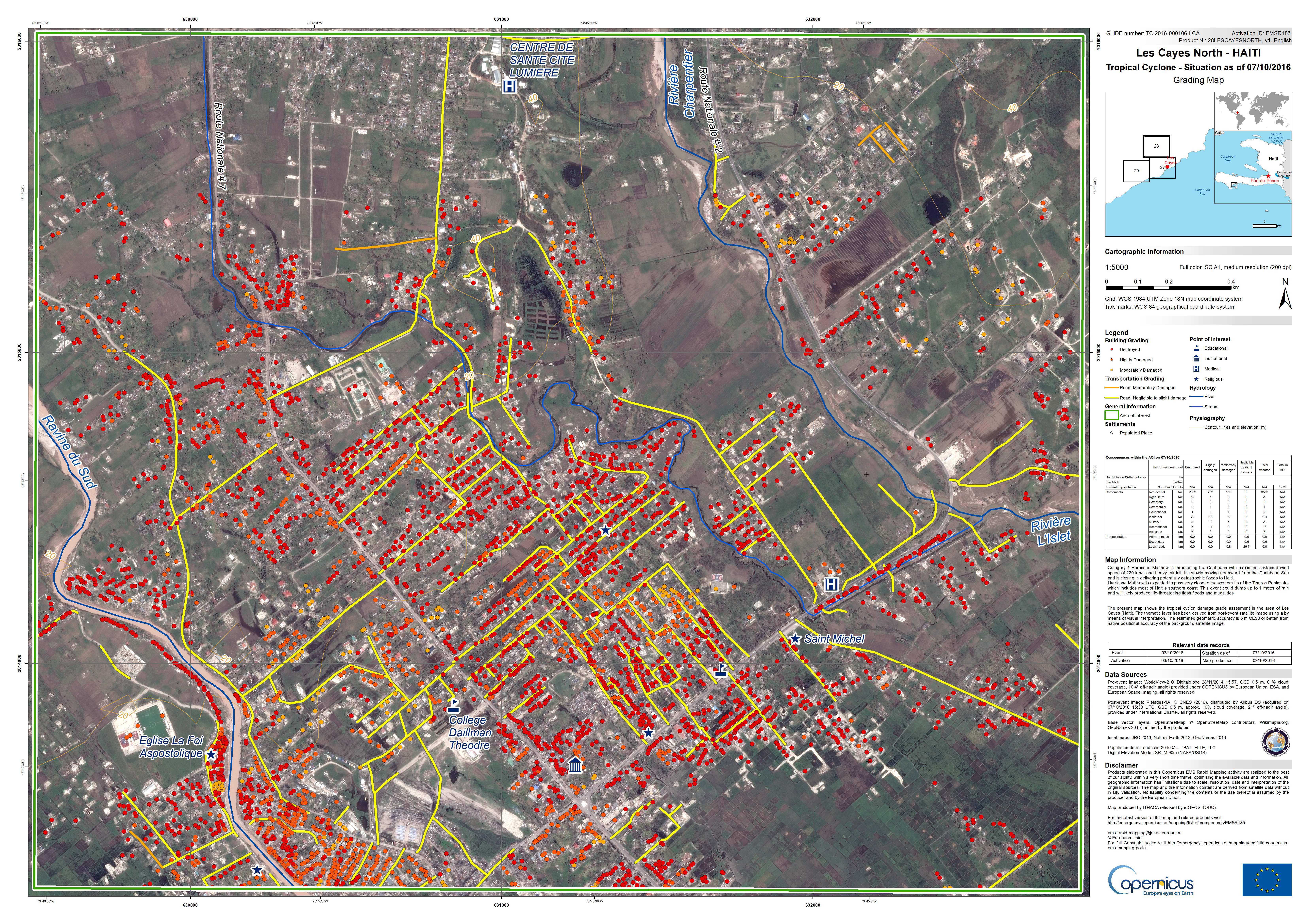
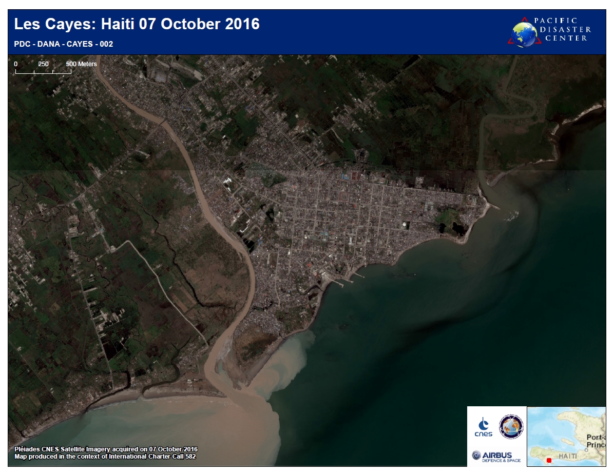
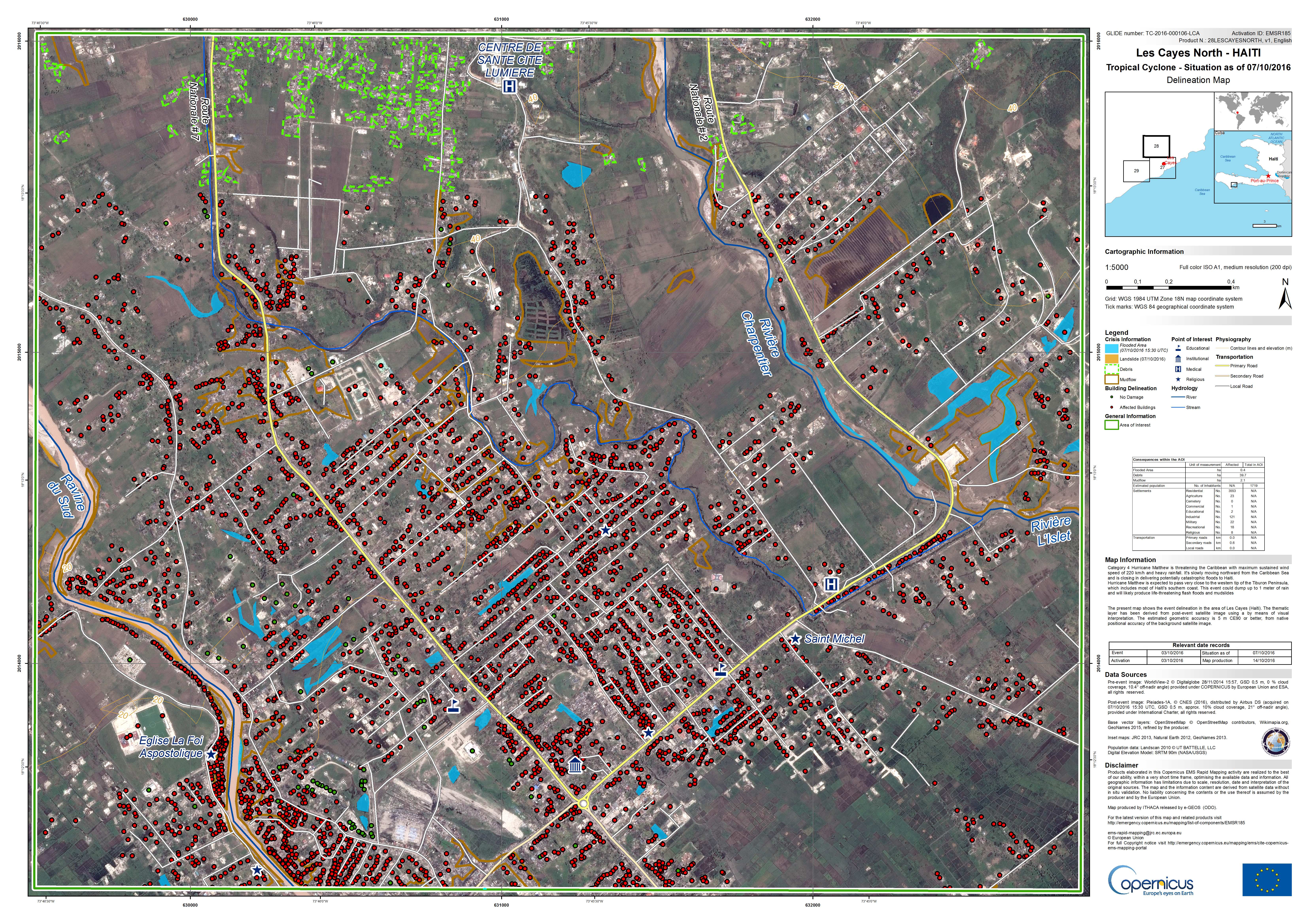
Situation in Les Cayes North, Haiti on 07/10/2016
版权: WorldView-2 © DigitalGlobe 2016
Pleiades © CNES 2016 - Distribution: Airbus Defence and Space, all rights reserved
Map produced by ITHACA
Information about the Product
已获得: Pre-disaster: 28/11/2014
Post-disaster: 07/10/2016
源: WorldView-2 / Pleiades
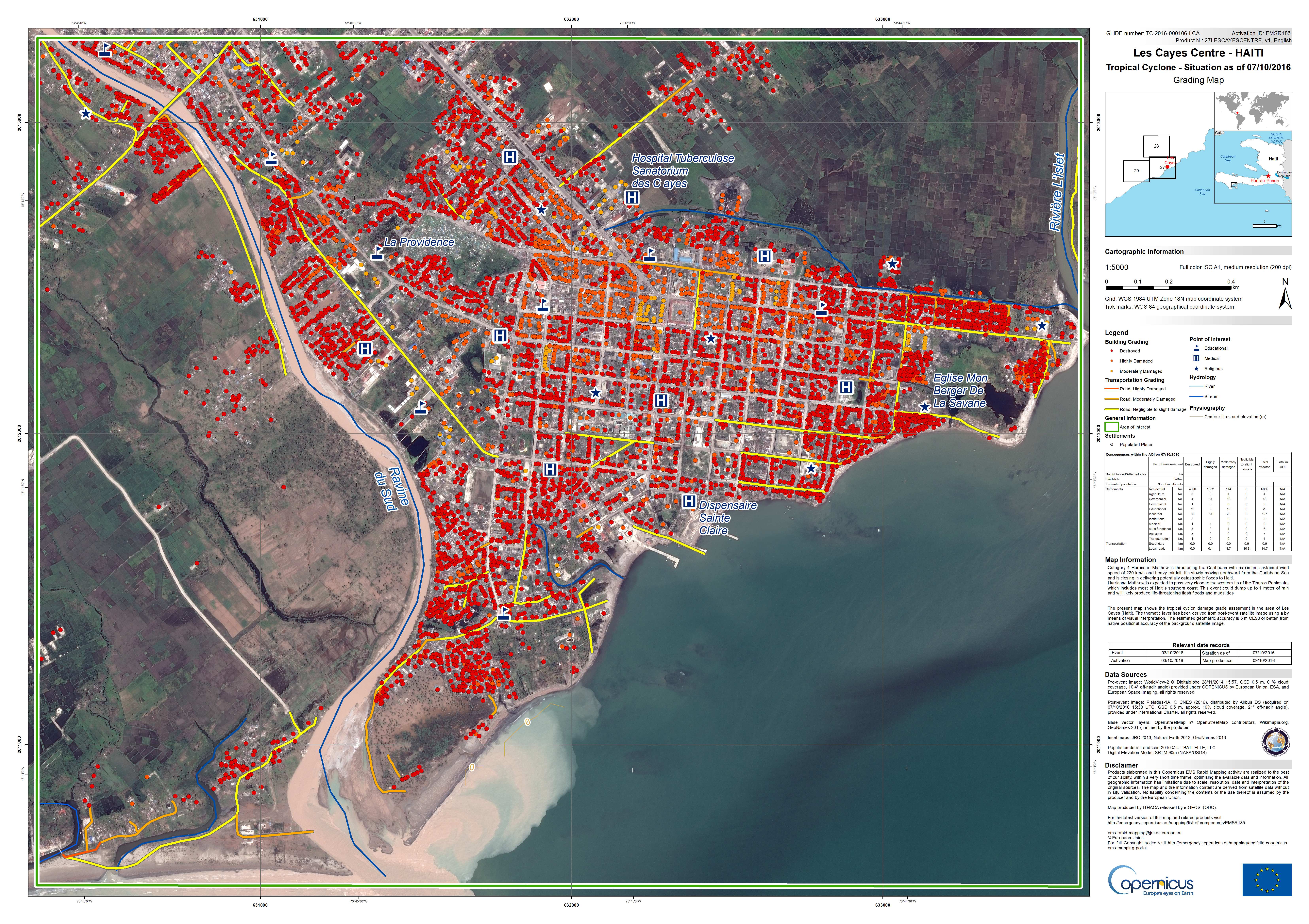
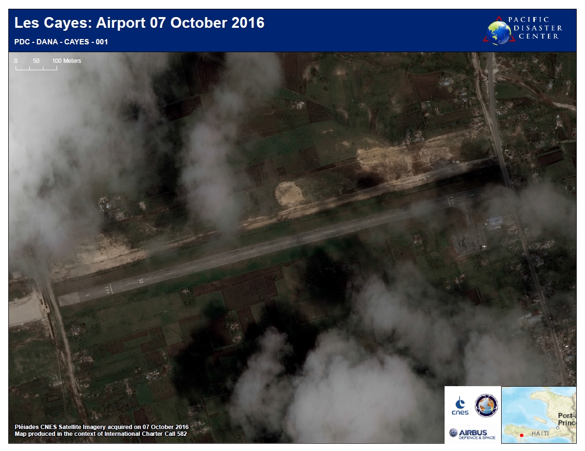
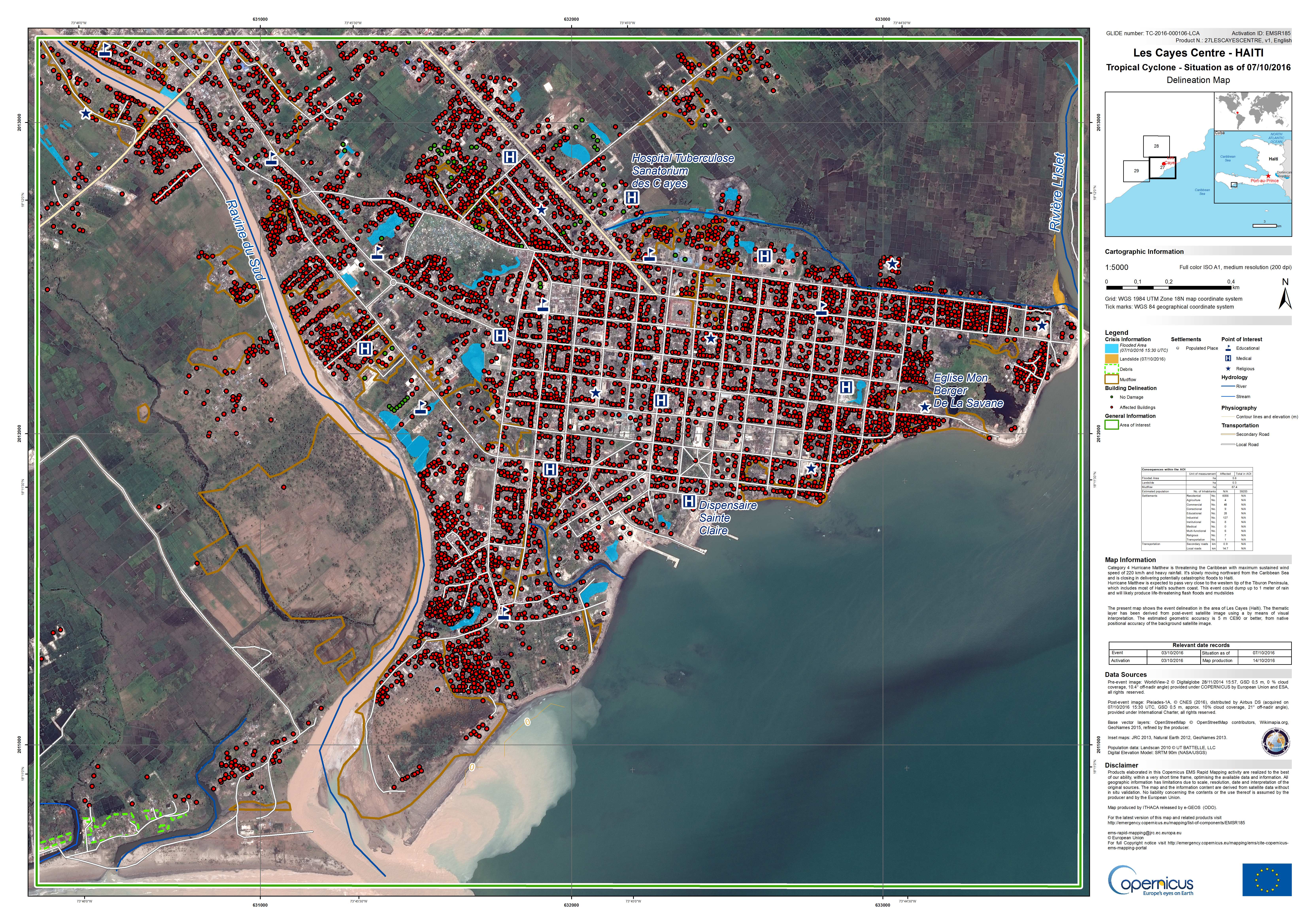
Situation in Les Cayes Centre, Haiti on 07/10/2016
版权: WorldView-2 © DigitalGlobe 2016
Pleiades © CNES 2016 - Distribution: Airbus Defence and Space, all rights reserved
Map produced by ITHACA
Information about the Product
已获得: Pre-disaster: 28/11/2014
Post-disaster: 07/10/2016
源: WorldView-2 / Pleiades

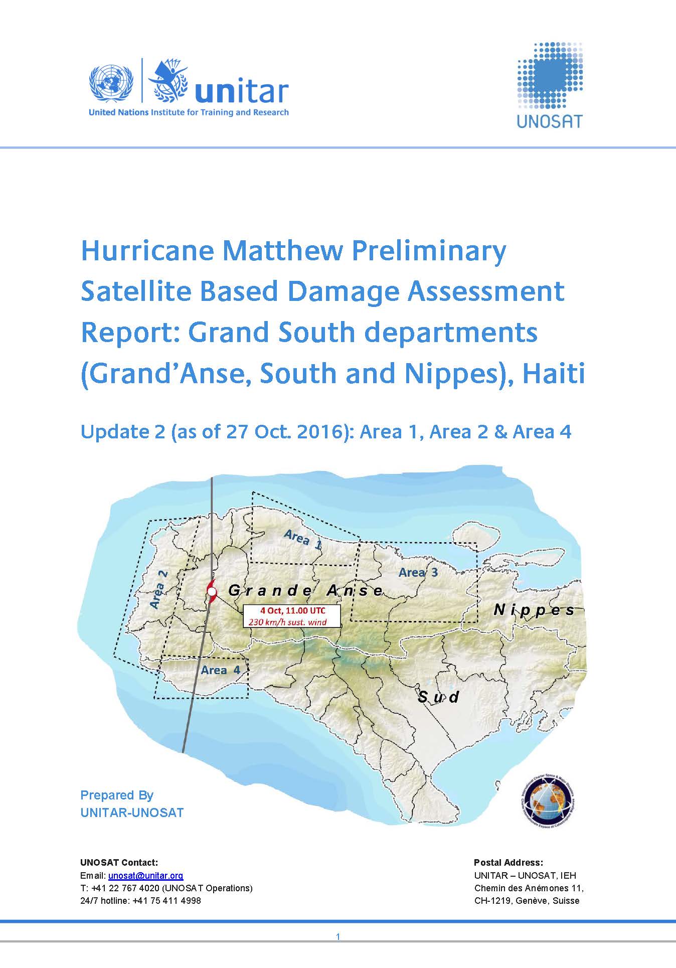
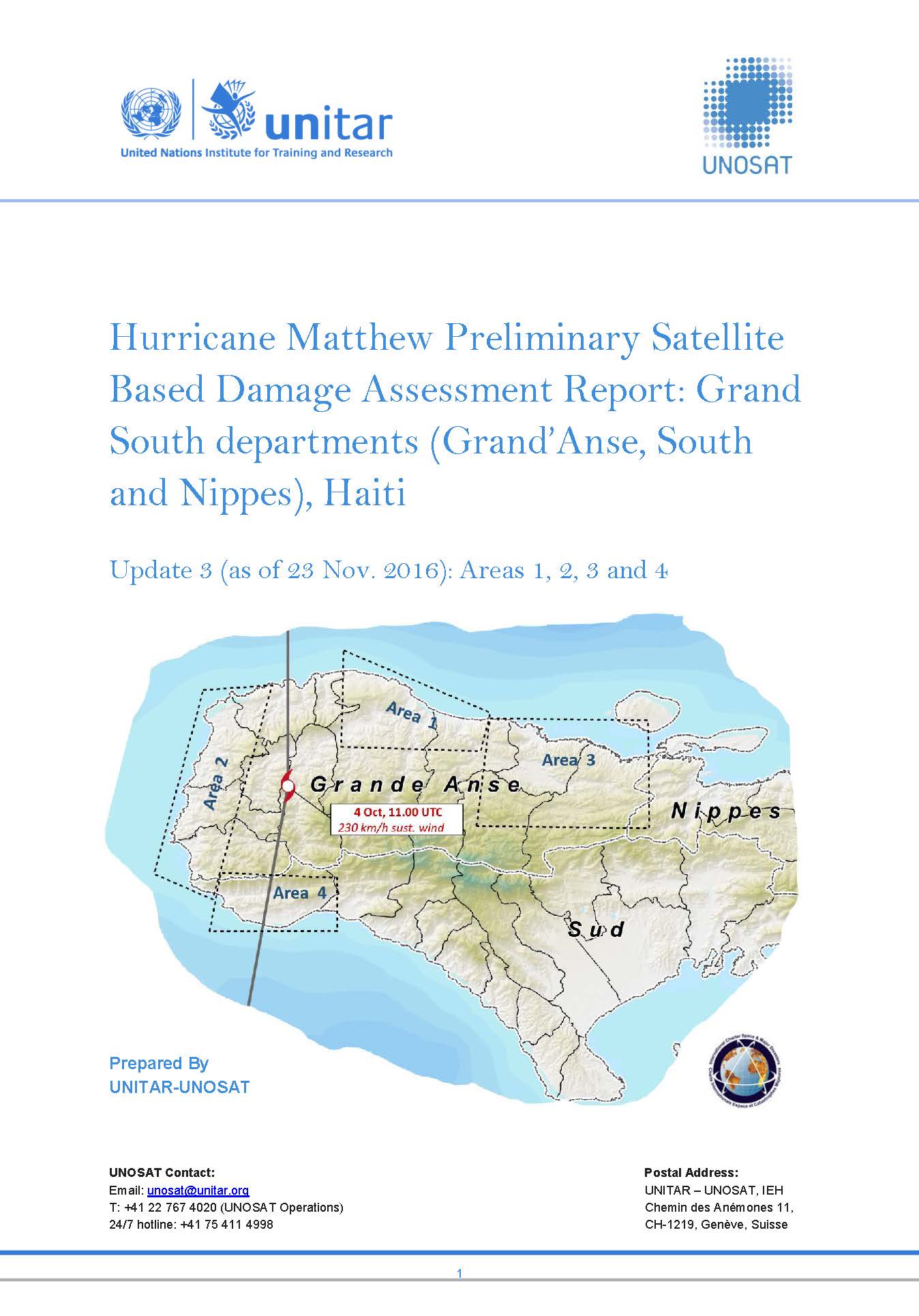
Hurricane Matthew Preliminary Satellite Based Damage Assessment Report: Grand South departments (Grand'Anse, South and Nippes), Haiti
Download the full report
版权: Report produced by: UNITAR/UNOSAT
Information about the Product
已获得: Pleiades: 12/10/2016 / WorldView-1: 08/12/2014, 01/05/2015, 09/05/2015 and 16/06/2015 / WorldView-2: 9/10/2016 & 17/10/2016 / WorldView-3: 17/10/2015
源: Pleiades / WorldView-1 / WorldView-2 / Worldview-3
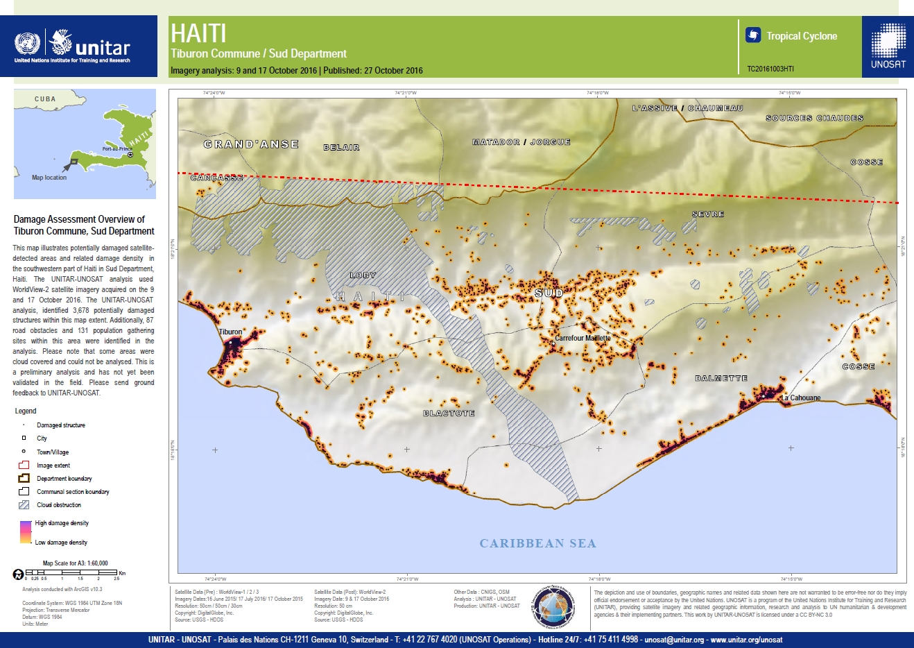
Damage assessment overview of Tiburon Commune, Sud Department
版权: Worldview © DigitalGlobe 2016
Map produced by UNITAR/UNOSAT
Information about the Product
已获得: WorldView-1 / 2 / 3: 16/06/2015, 17/07/2016, 17/10/2015
WorldView-2: 09/10/2016 and 17/10/2016
源: WorldView-1, 2 and 3
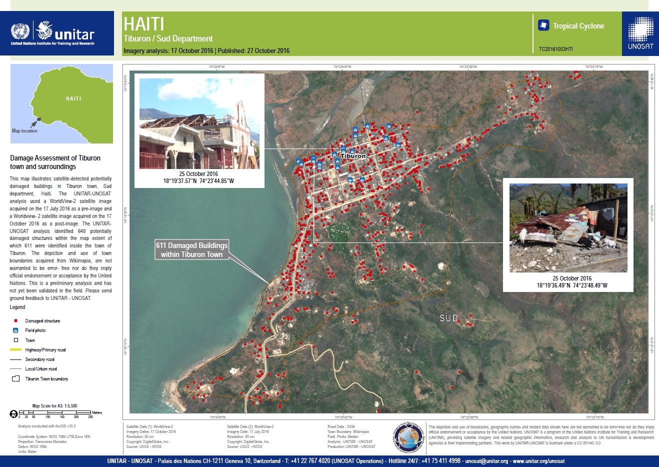
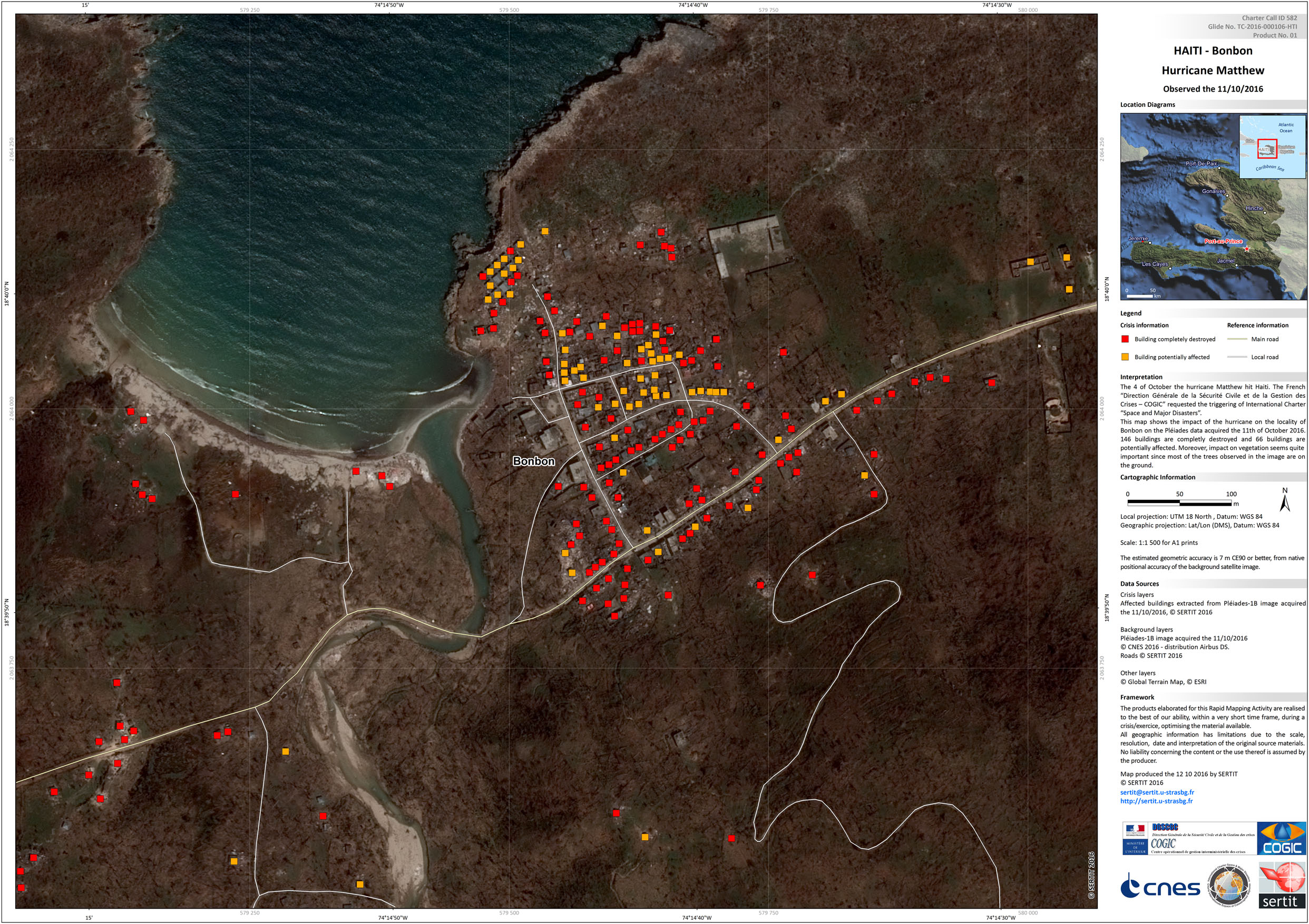
Damage assessment of Tiburon town and surroundings
版权: WorldView-2 © DigitalGlobe 2016
Map produced by UNITAR/UNOSAT
Information about the Product
已获得: Pre-disaster: 17/07/2016
Post-disaster: 17/10/2016
源: WorldView-2
Hurricane Matthew preliminary satellite damage report - Grand'Anse Département, Haiti - Update 1
Download the full report
版权: Report created by UNITAR/UNOSAT
Information about the Product
源: Pleiades: 07/10/2016 and 12/10/2016
WorldView-1: 01/05/2015, 09/05/2015 and 08/12/2014
WorldView-2: 17/07/2016
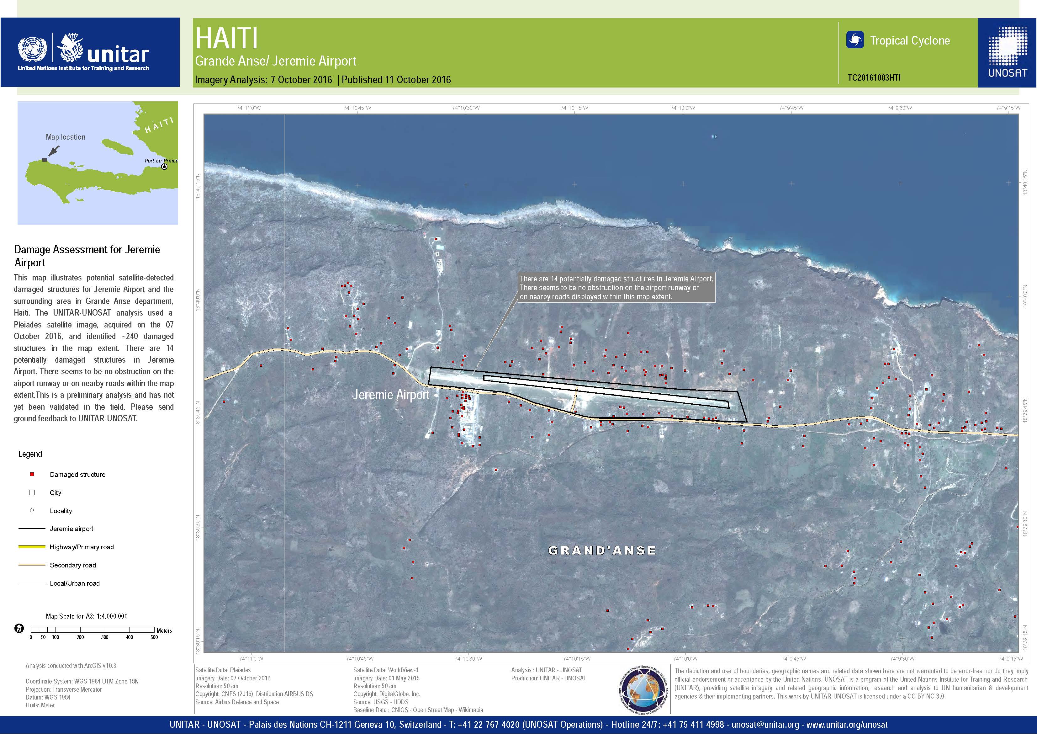
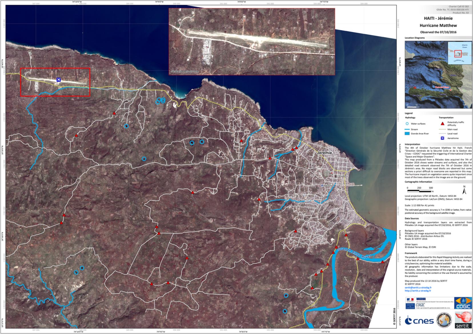
Damage assessment for Jeremie Airport
版权: Pleiades © CNES 2016 - Distribution: Airbus Defence and Space, all rights reserved
Map produced by UNITAR/UNOSAT
Information about the Product
已获得: 07/10/2016
源: Pleiades
Hurricane Matthew preliminary satellite damage report - Grand'Anse Département, Haiti
Download the full report
版权: Report produced by UNITAR/UNOSAT
Information about the Product
已获得: Pleiades: 07/10/2016
WorldView-1: 01/05/2015 and 08/12/2014
源: Pleiades / WorldView-1

Satellite detected waters in Corail and Pestel Communes, Grande Anse, Haiti
版权: RADARSAT-2 Data and Products © MacDonald, Dettwiler and Associates Ltd. (2016) - All Rights Reserved. RADARSAT is an official trademark of the Canadian Space Agency.
Map produced by UNITAR/UNOSAT
Information about the Product
已获得: 08/10/2016
源: RADARSAT-2

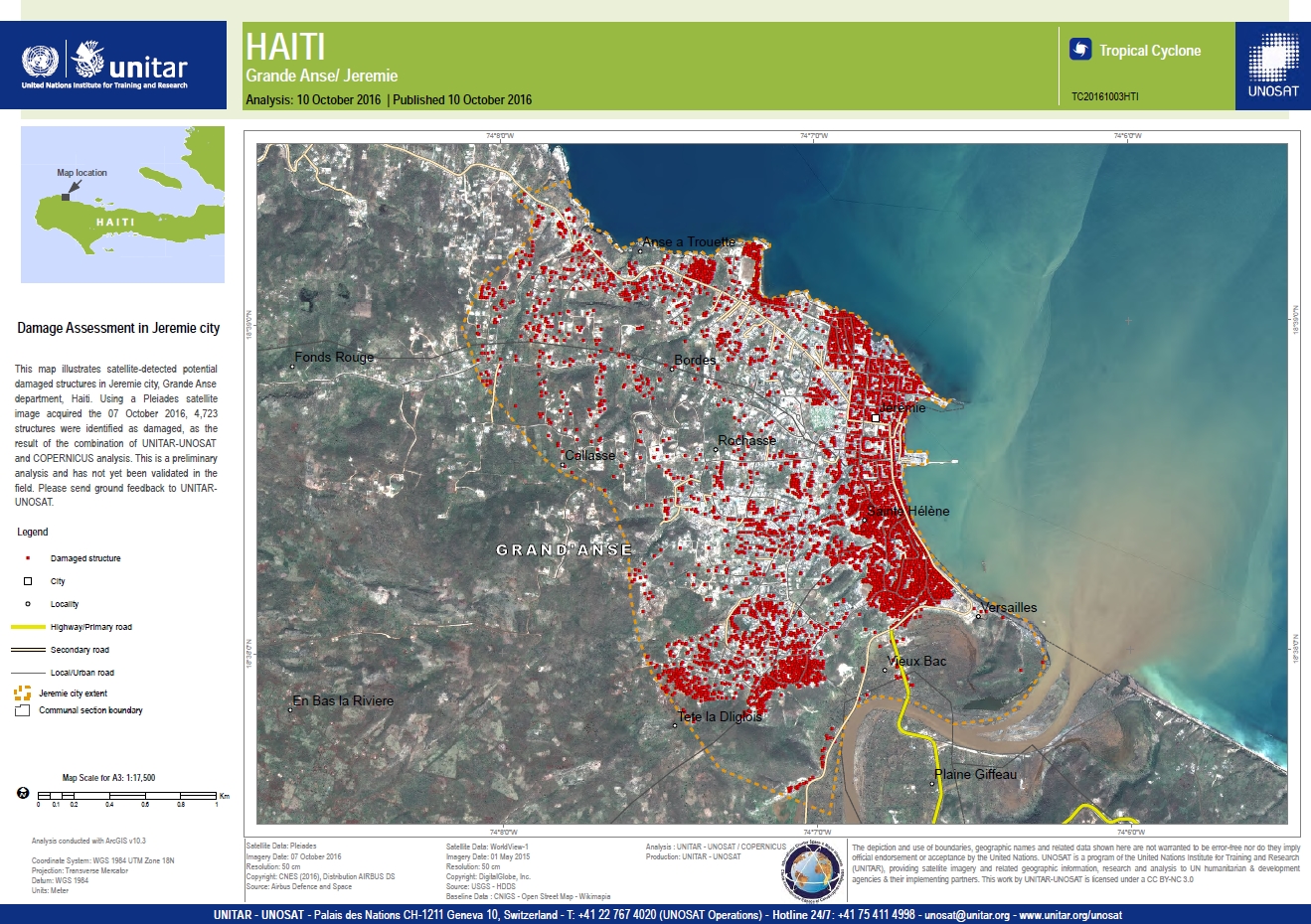
Damage assessment in Jeremie City
版权: Worldview-1 © DigitalGlobe 2016
Pleiades © CNES 2016 - Distribution: Airbus Defence and Space, all rights reserved
Map produced by UNITAR/UNOSAT
Information about the Product
已获得: WorldView-1: 01/05/2015
Pleiades: 07/10/2016
源: WorldView-1 / Pleiades
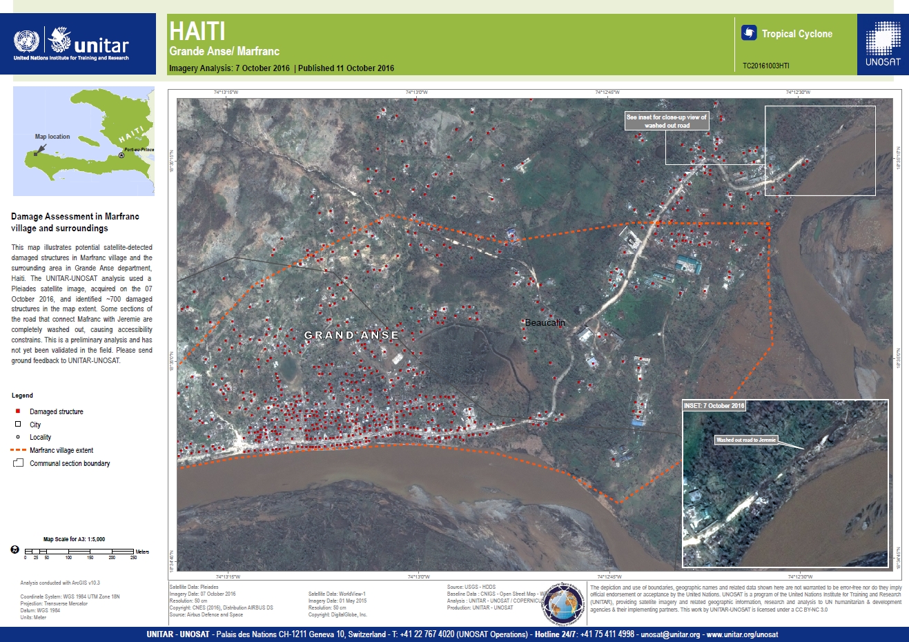
Damage assessment in Marfranc village and surroundings
版权: Worldview-1 © DigitalGlobe 2016
Pleiades © CNES 2016 - Distribution: Airbus Defence and Space, all rights reserved
Map produced by UNITAR/UNOSAT
Information about the Product
已获得: WorldView-1: 01/05/2015
Pleiades: 07/10/2016
源: WorldView-1 / Pleiades
Damage assessment of Grande Anse and Jeremie Airport, Haiti
版权: Worldview-1 © DigitalGlobe 2016
Pleiades © CNES 2016 - Distribution: Airbus Defence and Space, all rights reserved
Map produced by UNITAR/UNOSAT
Information about the Product
已获得: WorldView-1: 01/05/2015
Pleiades: 07/10/2016
源: WorldView-1 / Pleiades
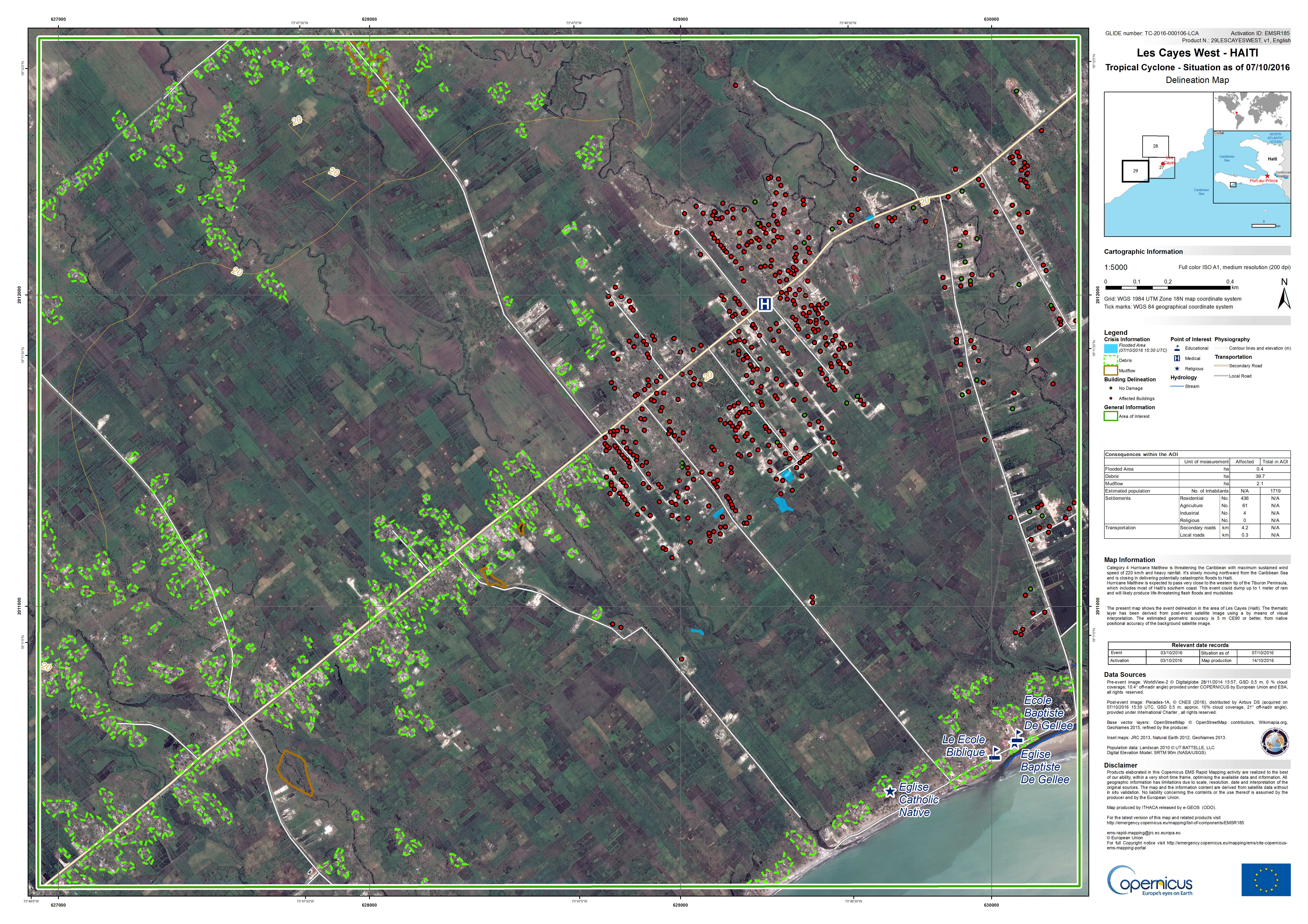
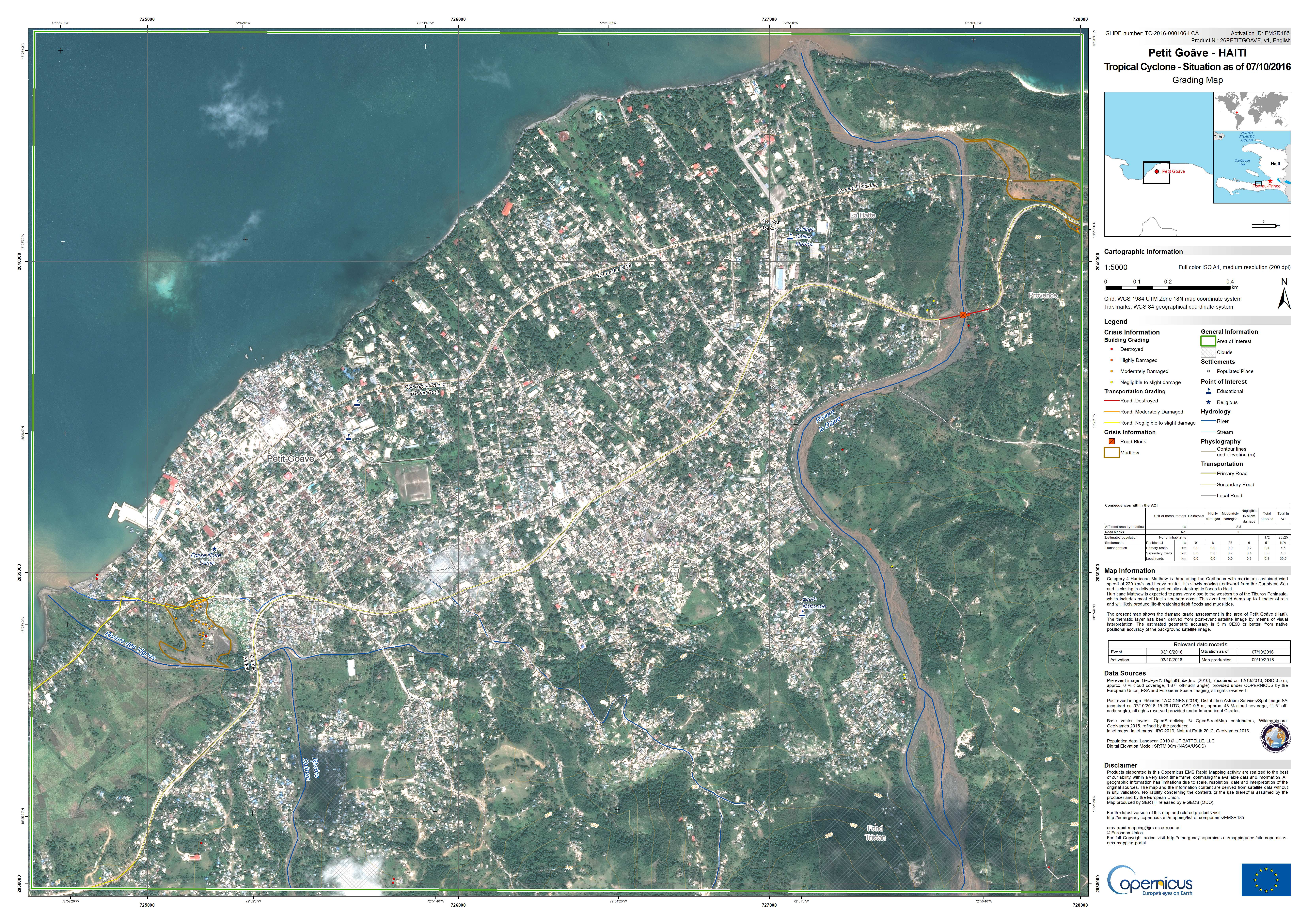
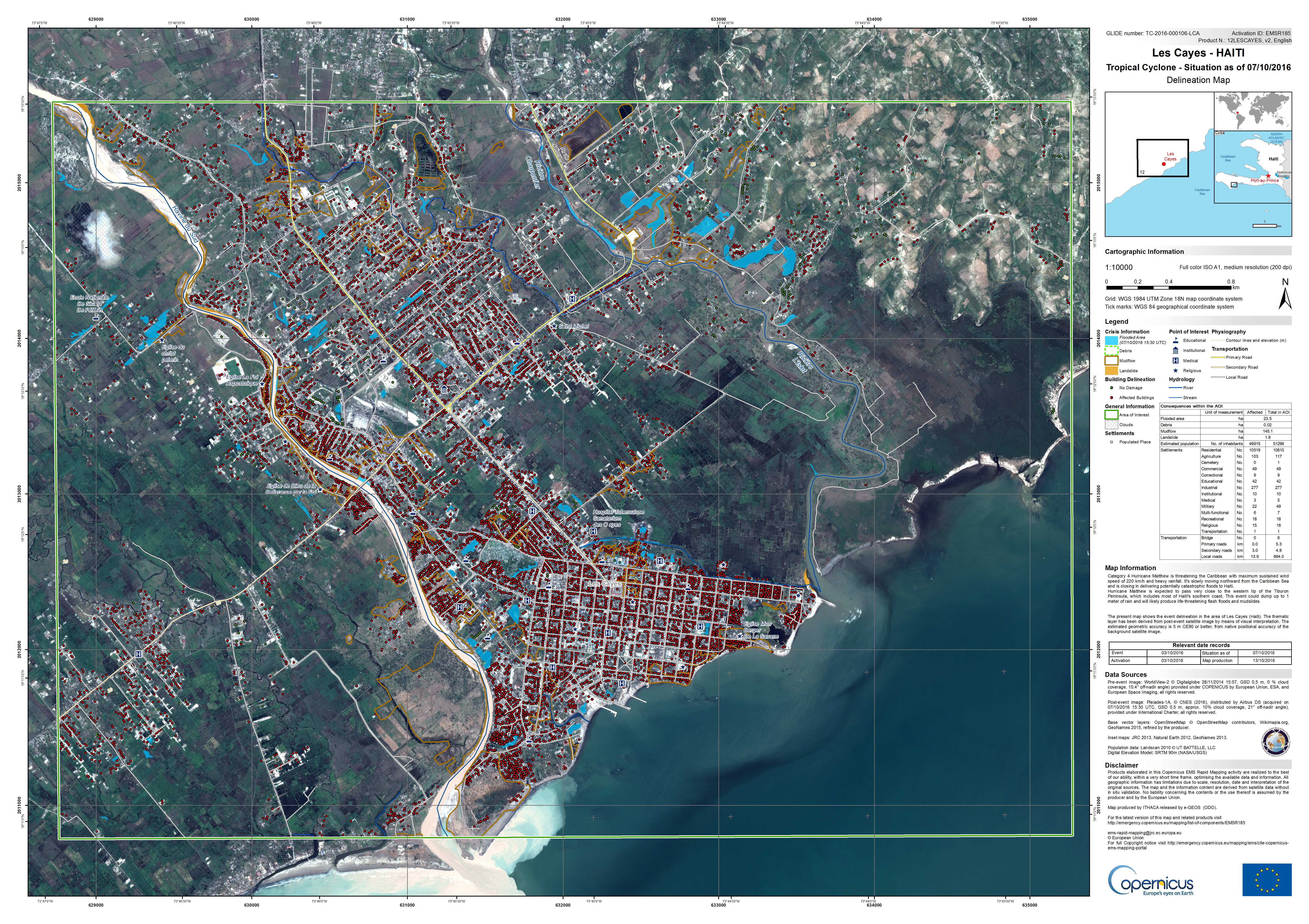
Situation map as of 07 Oct 2016, Les Cayes West, Haiti
版权: WorldView-2 © DigitalGlobe 2016
Pleiades © CNES 2016 - Distribution: Airbus Defence and Space, all rights reserved
Map produced by ITHACA
Information about the Product
已获得: Worldview-2: 28/11/2014
Pleiades: 07/10/2016
源: Worldview-2 / Pleiades-1A
Situation map as of 07 Oct 2016, Les Cayes North, Haiti
版权: WorldView-2 © DigitalGlobe 2016
Pleiades © CNES 2016 - Distribution: Airbus Defence and Space, all rights reserved
Map produced by ITHACA
Information about the Product
已获得: Worldview-2: 28/11/2014
Pleiades: 07/10/2016
源: Worldview-2 / Pleiades-1A
Situation map as of 07 Oct 2016, Les Cayes Centre, Haiti
版权: WorldView-2 © DigitalGlobe 2016
Pleiades © CNES 2016 - Distribution: Airbus Defence and Space, all rights reserved
Map produced by SERTIT
Information about the Product
已获得: Worldview-2: 28/11/2014
Pleiades: 07/10/2016
源: Worldview-2 / Pleiades-1A
 返回完整的响应档案

