 English
 Spanish
 French
 Chinese
 Russian
 Portuguese
 Latest Activation
Charter activations
Flooding in West Africa
Torrential rains in late August and early September have caused a wide area flooding in West Africa. Over 500,000 people have been affected in 11 countries in West Africa (Mali, Burkina Faso, Mauritania, Niger, Côte d'Ivoire, Senegal, the Gambia, Liberia, Togo, Sierra Leone and Ghana).
The situation is especially worrisome in Ghana with 260,000 people affected; Burkina Faso with 35,000 and Togo with 20,389. So far, Ghana, Burkina Faso and Mauritania have requested international assistance or solidarity.
| Type of Event: | Flooding |
| Location of Event: | West Africa |
| Date of Charter Activation: | 14/09/2007 |
| Charter Requestor: | UNOOSA on behalf of UNOCHA |
| Project Management: | UNOSAT |
Products
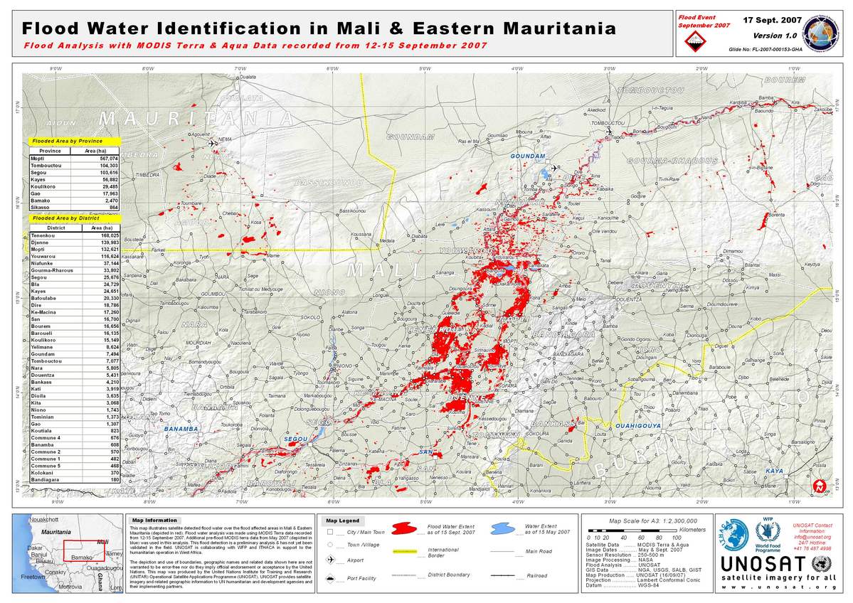
Mali Flood Map 17/09/2007
Copyright: NASA 2007 Image processing
Map created 17/09/2007 by UNOSAT
Information about the Product
Acquired: 12-15/09/2007 and 05/2007 Satellite-detected flood water over the flood affected areas in Mali and eastern Mauritania (red). Flood water analysis was made using MODIS Terra data recorded from 12-15 September 2007, with additional pre-flood MODIS terra data from May 2007 (blue). Preliminary analysis not yet validated in the field.
Source: MODIS Terra and Aqua, 250-500m/pixel resolution
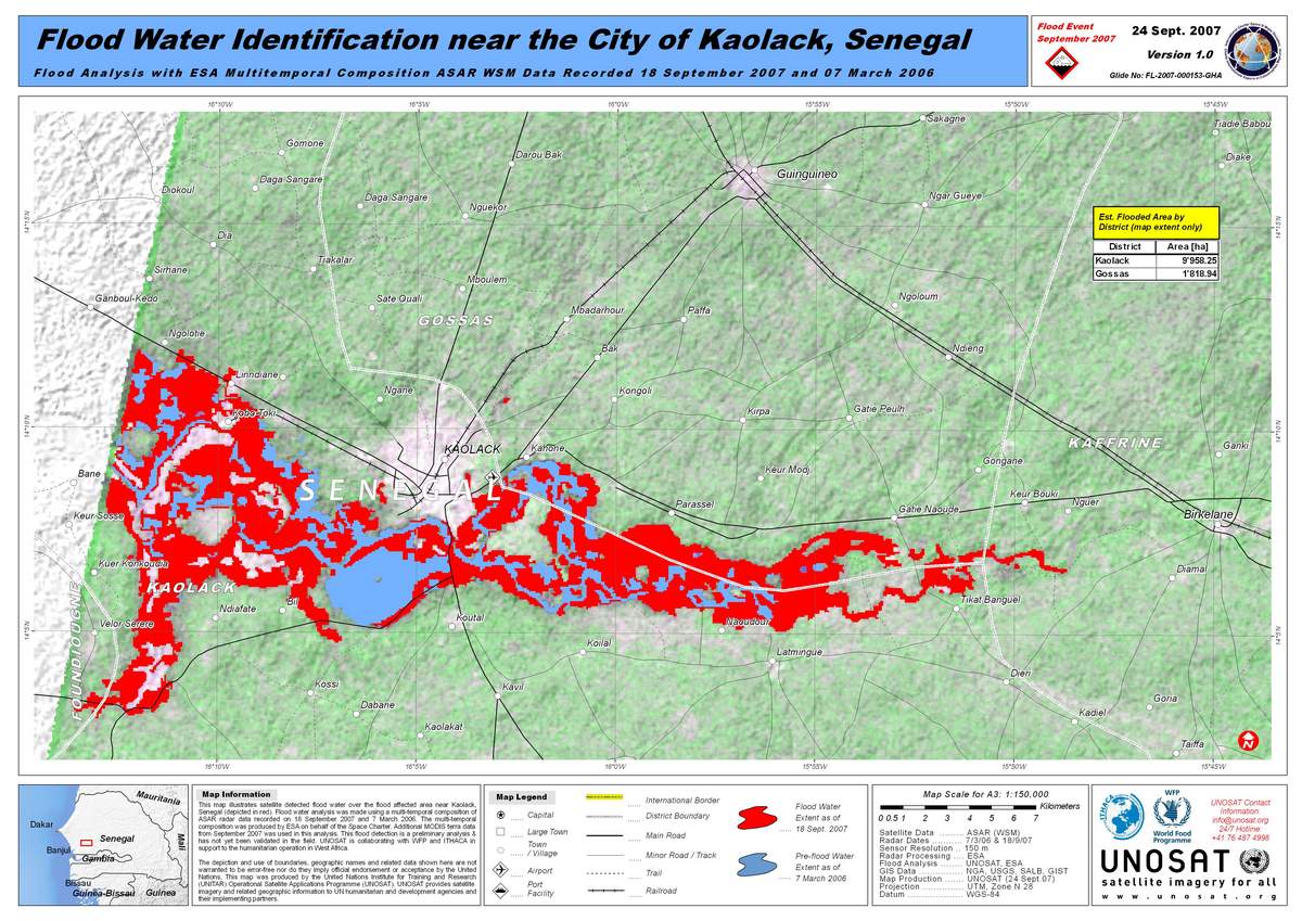
Envisat ASAR, Floods in Senegal
Copyright: ESA 2006, 2007; credit NASA 2007 Image processing, map created 21/09/2007 by UNOSAT.
Information about the Product
Acquired: 07/03/2006 and 18/09/2007 Satellite-detected flood water over the flood-affected area near Kaolack, Senegal (in red). Flood water analysis was made using a multitemporal composition of ASAR radar data recorded on 18 September 2007 and 7 March 2006. The multitemporal composition was produced by ESA on behalf of the Space Charter. Additional MODIS terra data from September 2007 was used in this analysis. Preliminary analysis not yet validated in the field.
Source: Envisat ASAR WSM; MODIS on Terra, 150m/pixel resolution.
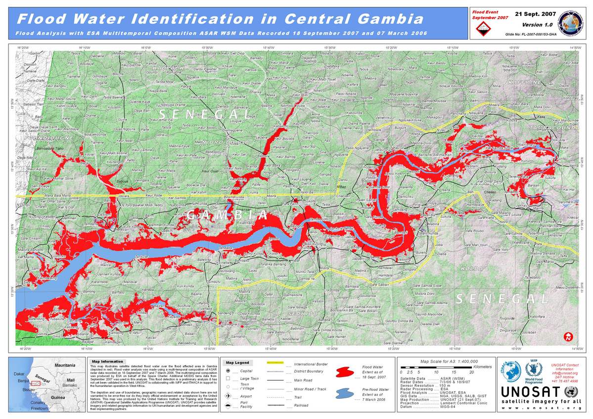
Envisat ASAR, Floods in Gambia
Copyright: ESA 2006, 2007; credit NASA 2007 Image processing, map created 21/09/2007 by UNOSAT.
Information about the Product
Acquired: 07/03/2006 and 18/09/2007 Satellite-detected flood water over the flood-affected area in Gambia (in red). Flood water analysis was made using a multitemporal composition of ASAR radar data recorded on 18 September 2007 and 7 March 2006. The multitemporal composition was produced by ESA on behalf of the Space Charter. Additional MODIS Terra data from September 2007 was used in this analysis. Preliminary analysis not yet validated in the field.
Source: Envisat ASAR WSM; MODIS on Terra, 150m/pixel resolution.
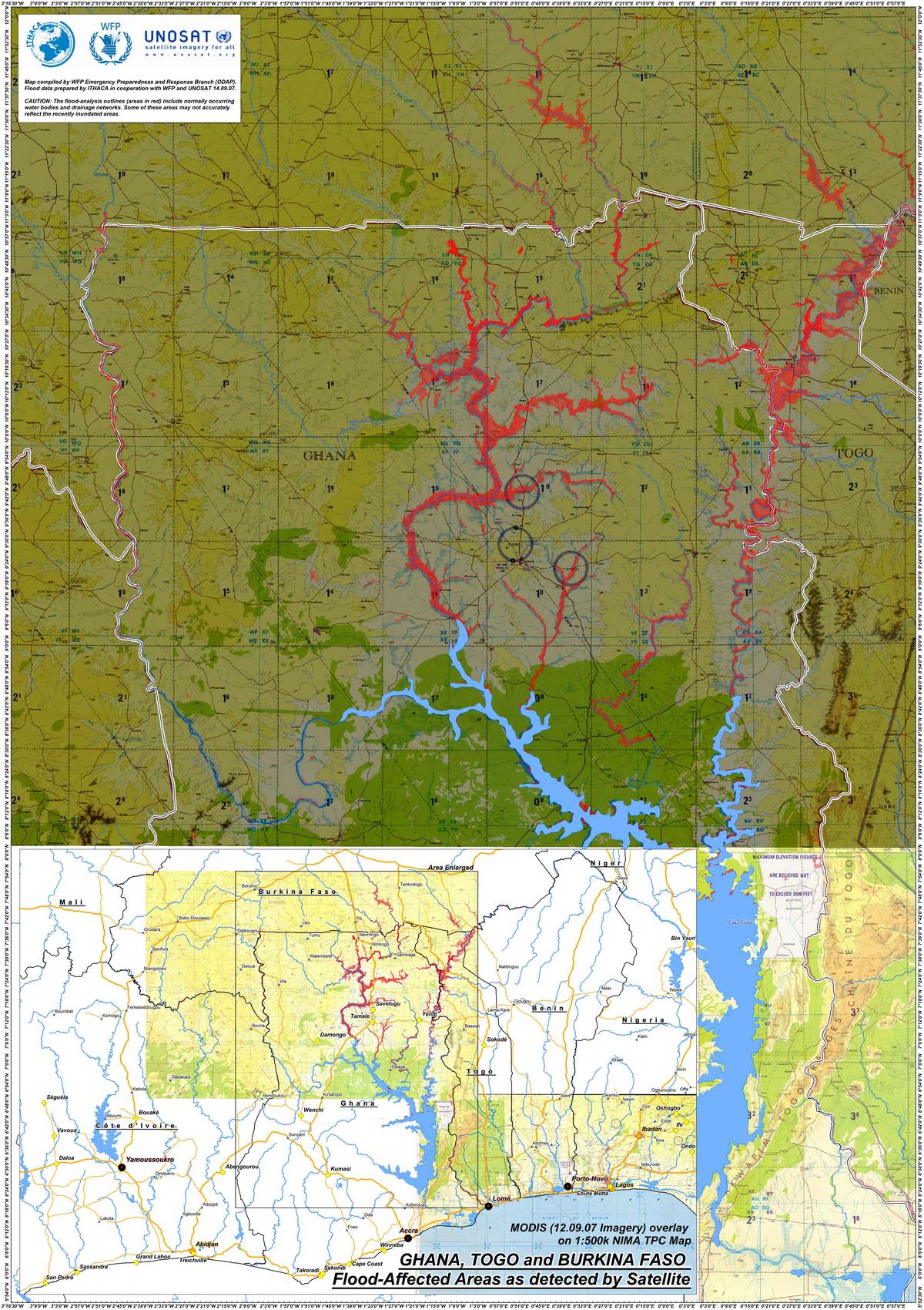
MODIS Overlay, Floods in Ghana, Togo, and Burkina
Copyright: NASA 2007 Image processing, map created 14/09/2007 by WFP ODAP.
Information about the Product
Acquired: 12-14/09/2007 Satellite-detected flood water over the flood affected area over Ghana, Togo and Burkina Faso (red). Total population figures estimated by province and district admin. units (levels 1 and 2). Preliminary analysis not yet validated in the field.
Source: MODIS on Aqua and Terra, 250-500m/pixel resolution.
 Back to the full activation archive

