 English
 Spanish
 French
 Chinese
 Russian
 Portuguese
 Последняя Активация
Charter activations
Typhoon Hagupit in the Philippines
Typhoon Hagupit (known locally as Ruby) made landfall in the Philippines on 6 December.
On landfall in the eastern Philippines, the storm was Category Three and left 21 people dead. It has been estimated that almost a million people were affected by Hagupit.
In the days before the storm made landfall, Hagupit had strengthened to a Category Five storm, the highest category on the Saffir-Simpson scale, but weakened to Category Three shortly before it hit the Philippines. In November last year, the Category Five Typhoon Haiyan had a devastating effect on the Philippines, leaving over seven thousand dead, millions homeless, and a great deal of destruction. The archipelago was still recovering from this disaster when Hagupit struck.
Due to fears over the threat posed by the typhoon, hundreds of thousands of people evacuated in the days before Hagupit arrived. They took refuge in emergency shelters set up by the government, or moved to safer locations during the storm. This early evacuation, in combination with Hagupit's weaker than expected strength, has been given credit for saving many lives.
After landfall Hagupit moved slowly in a north-west direction, passing over the northern part of the Philippines over a period of two days. The storm has been causing heavy rain and bringing strong winds to the islands, which has caused major damage to homes in the eastern part of the Philippines, and resulted in flooding. Reports indicate that nearly 20,000 tonnes of rice crops have been destroyed by the storm, which has prompted the Philippines to look for supplies elsewhere to ensure there is an adequate supply in 2015.
Analysis of the damage lists 38 thousands homes were destroyed by Hagupit and the typhoon affected almost four million people.
| Тип события: | Flood, Ocean Storm - Typhoon |
| Место события: | The Philippines |
| Date of Charter Activation: | 4 December 2014 |
| Время активации Хартии: | 12:35:00 |
| TЧасовой пояс в районе активации Хартии: | UTC+01:00 |
| Запрос на активацию поступил от: | UNITAR/UNOSAT on behalf of UN OCHA Philippines |
| Менеждер проекта от: | ESA |
Products
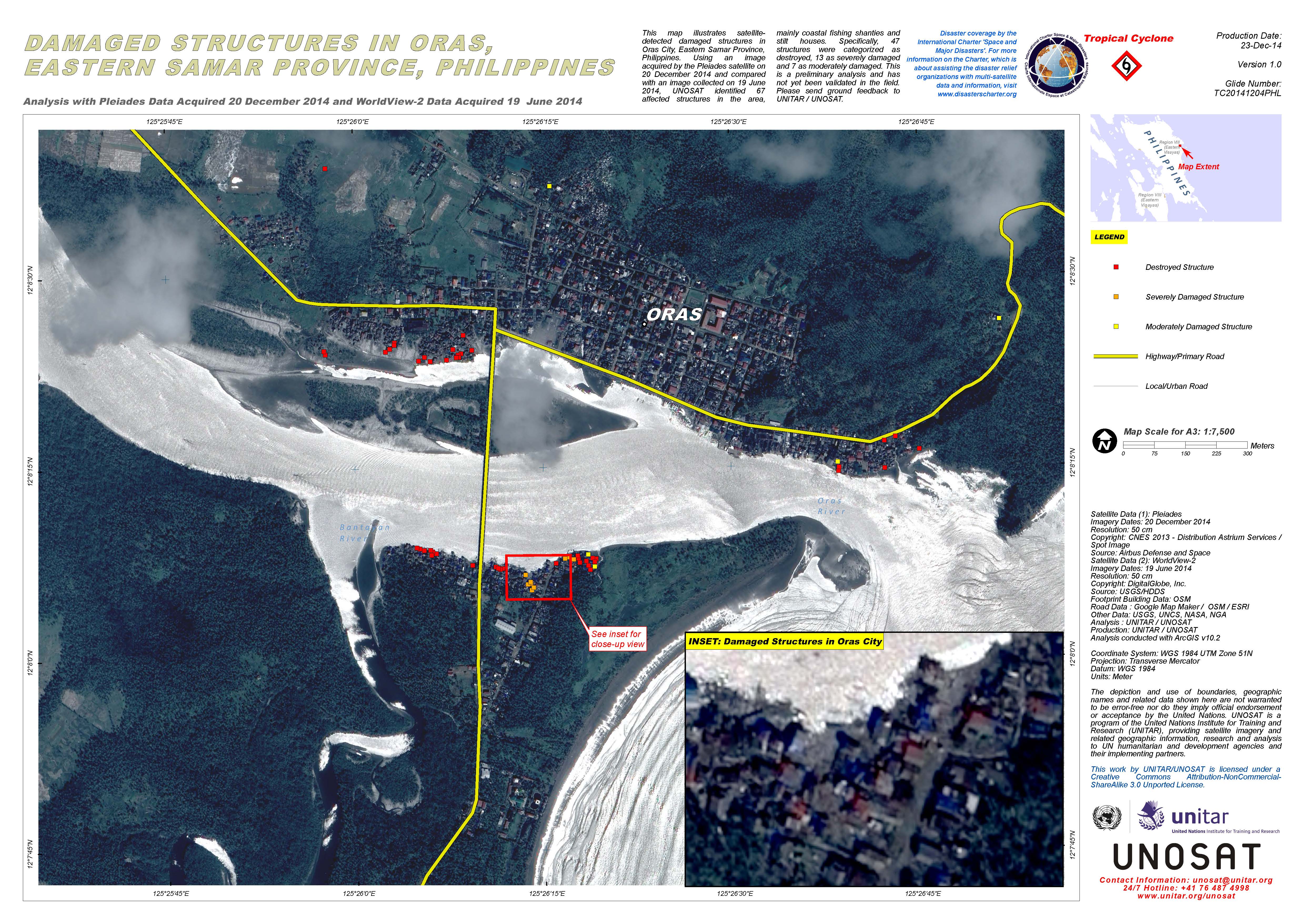
Damaged structures in Oras, Eastern Samar Province, in the Philippines
Авторские права: Pleiades © CNES 2014 - Distribution: Airbus Defence and Space, all rights reserved
WorldView-2 © DigitalGlobe Inc.
Map produced by UNITAR/UNOSAT
Information about the Product
Получено: Pleiades: 20/12/2014
WorldView-2: 19/06/2014
Источник: Pleiades / WorldView-2
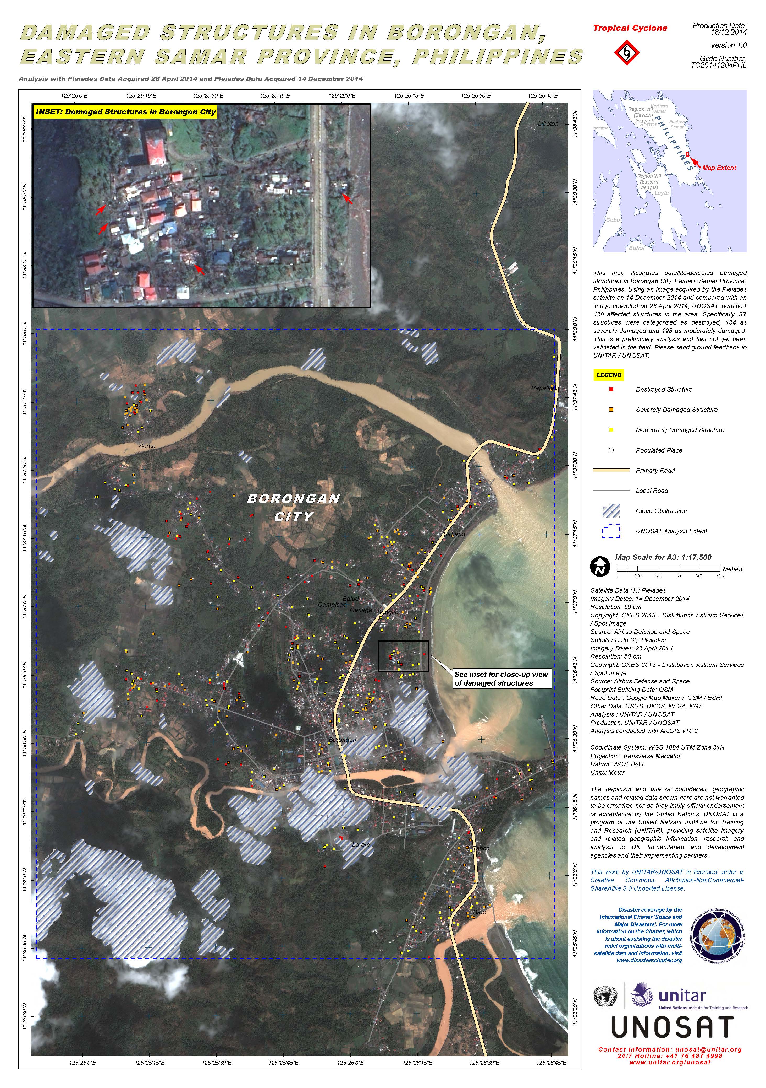
Damaged structures in Borongan, Eastern Samar Province, in the Philippines
Авторские права: Pleiades © CNES 2014 - Distribution: Airbus Defence and Space, all rights reserved
Map produced by UNITAR/UNOSAT
Information about the Product
Получено: Pre-disaster: 26/04/2014
Post-disaster: 14/12/2014
Источник: Pleiades
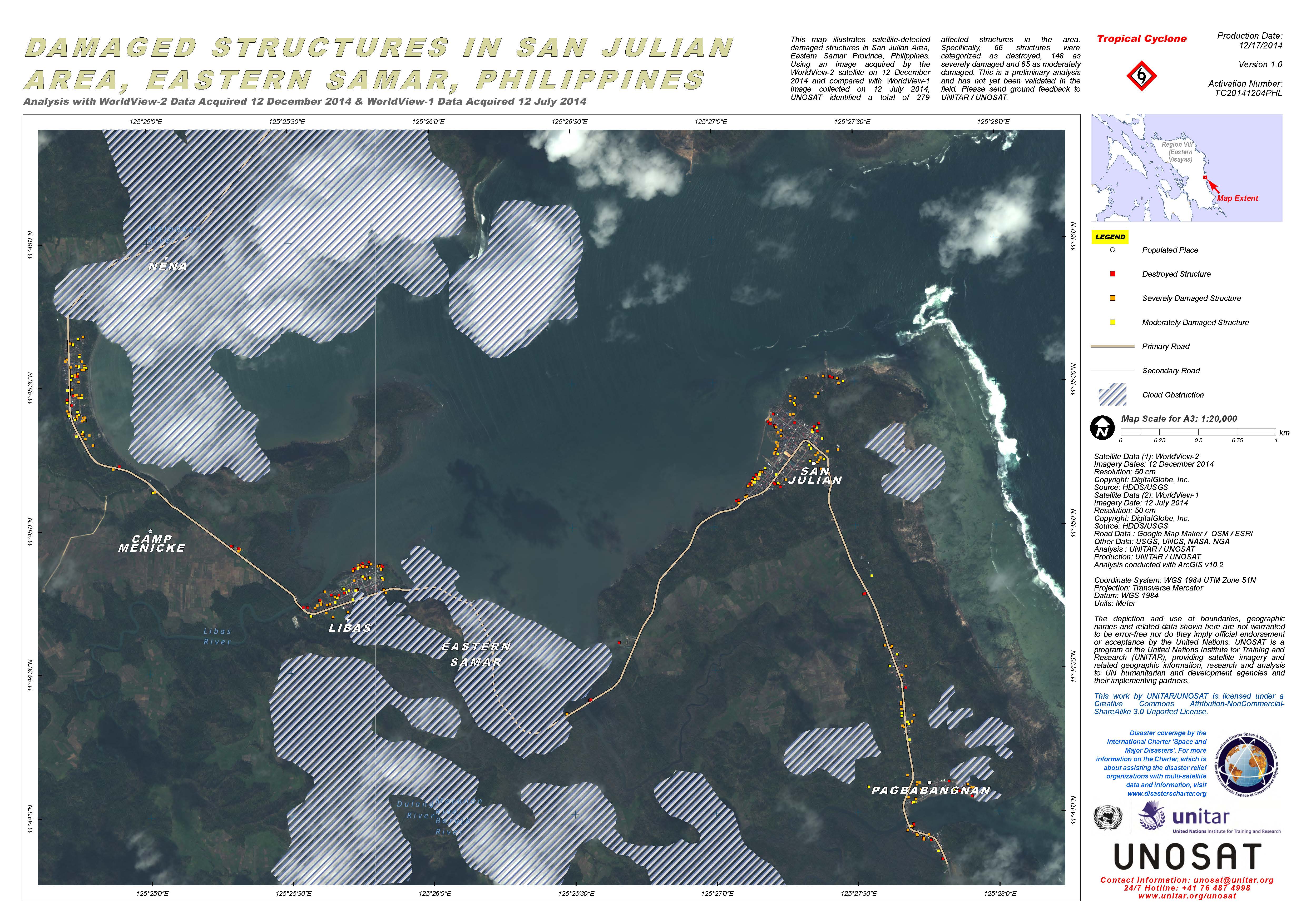
Damaged structures in San Julian area, Eastern Samar, in the Philippines
Авторские права: DigitalGlobe Inc.
Map produced by UNITAR/UNOSAT
Information about the Product
Получено: WorldView-2: 12/12/2014
WorldView-1: 12/07/2014
Источник: WorldView-2 / WorldView-1
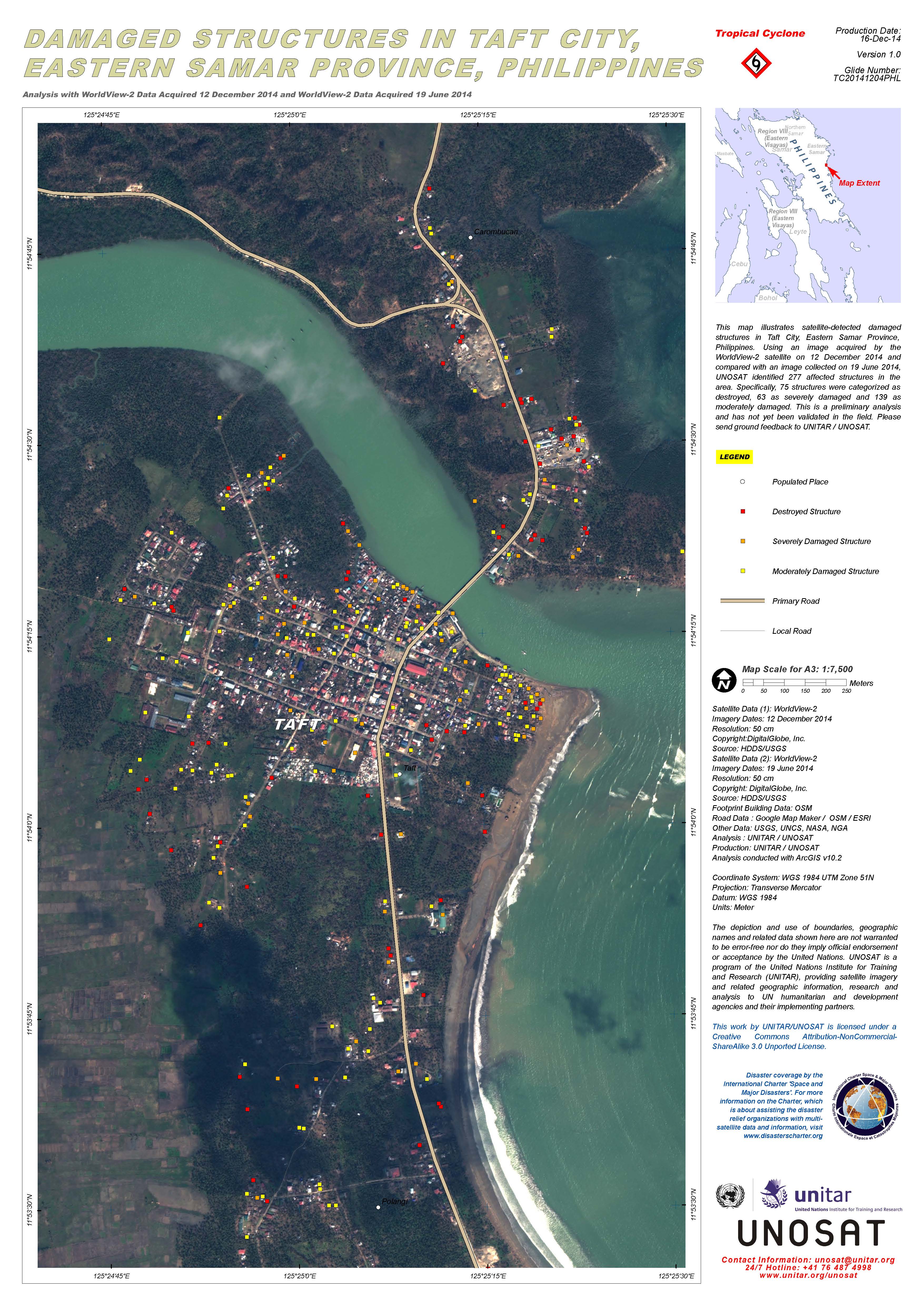
Damaged structures in Taft City, Eastern Samar Province, in the Philippines
Авторские права: DigitalGlobe Inc.
Map produced by UNITAR/UNOSAT
Information about the Product
Получено: Pre-disaster: 19/06/2014
Post-disaster: 12/12/2014
Источник: WorldView-2
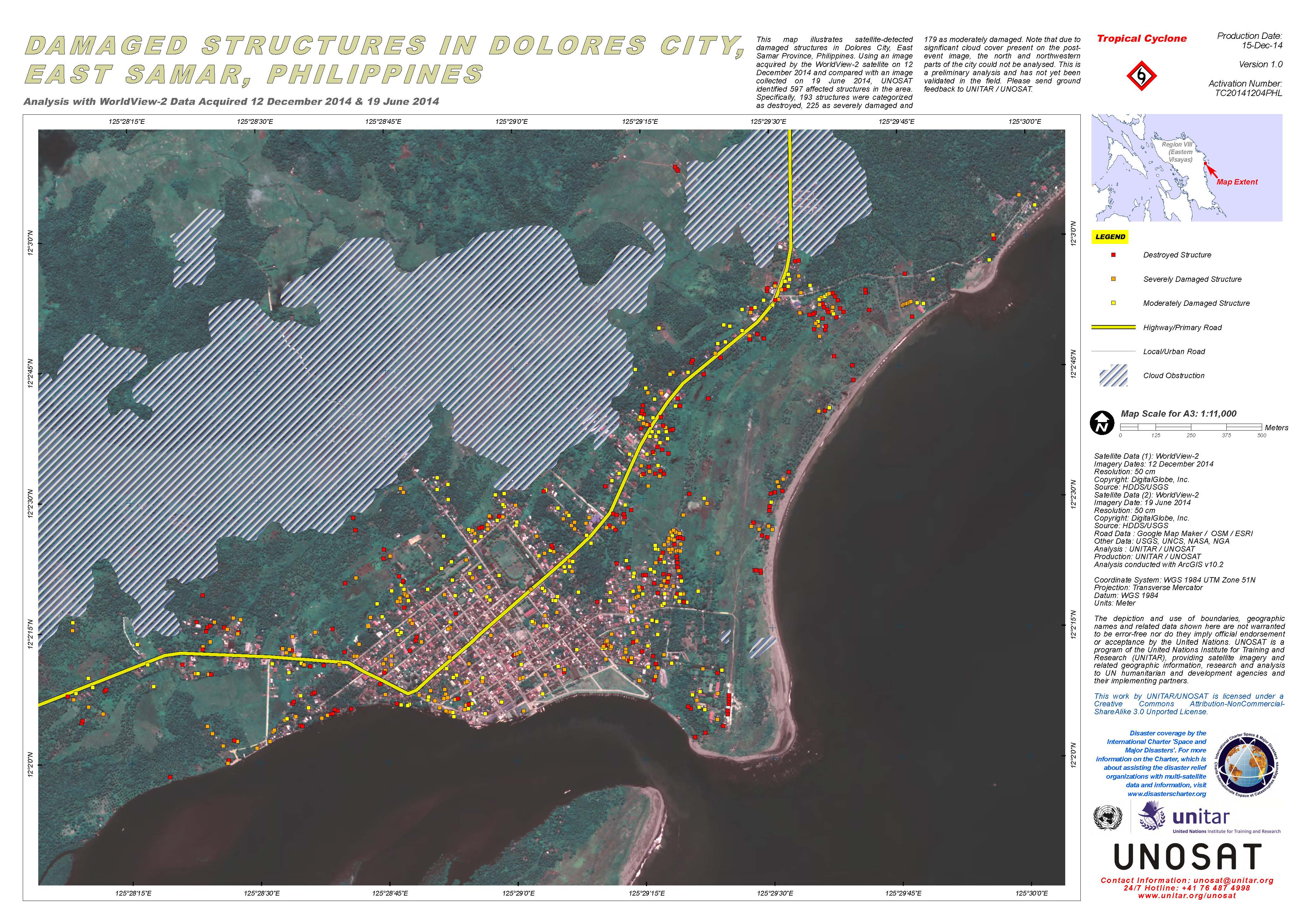
Damaged structures in Dolores City, East Samar, in the Philippines
Авторские права: DigitalGlobe Inc.
Map produced by UNITAR/UNOSAT
Information about the Product
Получено: Pre-disaster: 19/06/2014
Post-disaster: 12/12/2014
Источник: WorldView-2
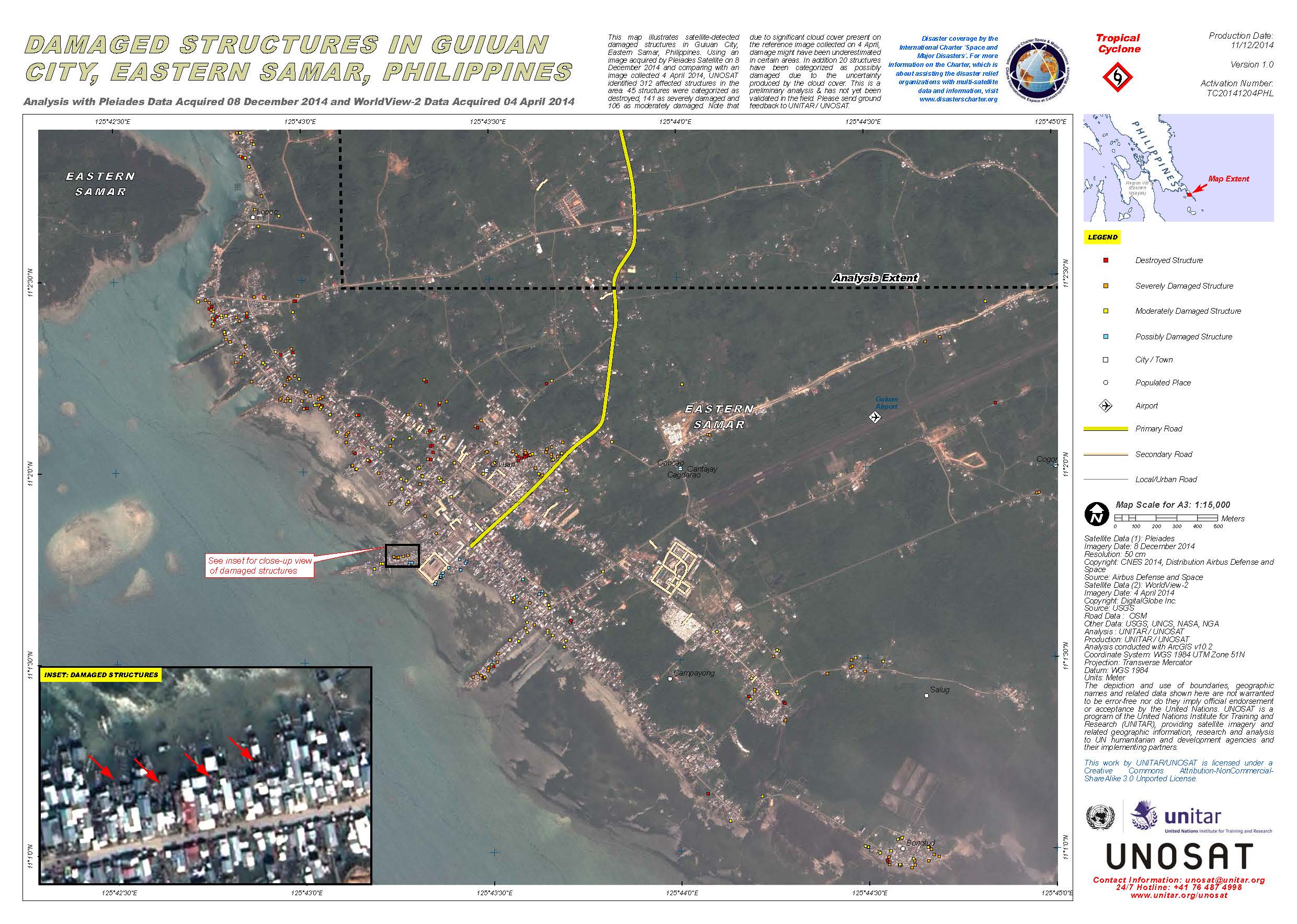
Damaged structures in Guiuan City, Eastern Samar, in the Philippines
Авторские права: Pleiades © CNES 2014 - Distribution: Airbus Defence and Space, all rights reserved
WorldView-2 © DigitalGlobe Inc.
Map produced by UNITAR/UNOSAT
Information about the Product
Получено: Pleiades: 08/12/2014
WorldView-2: 04/04/2014
Источник: Pleiades / WorldView-2
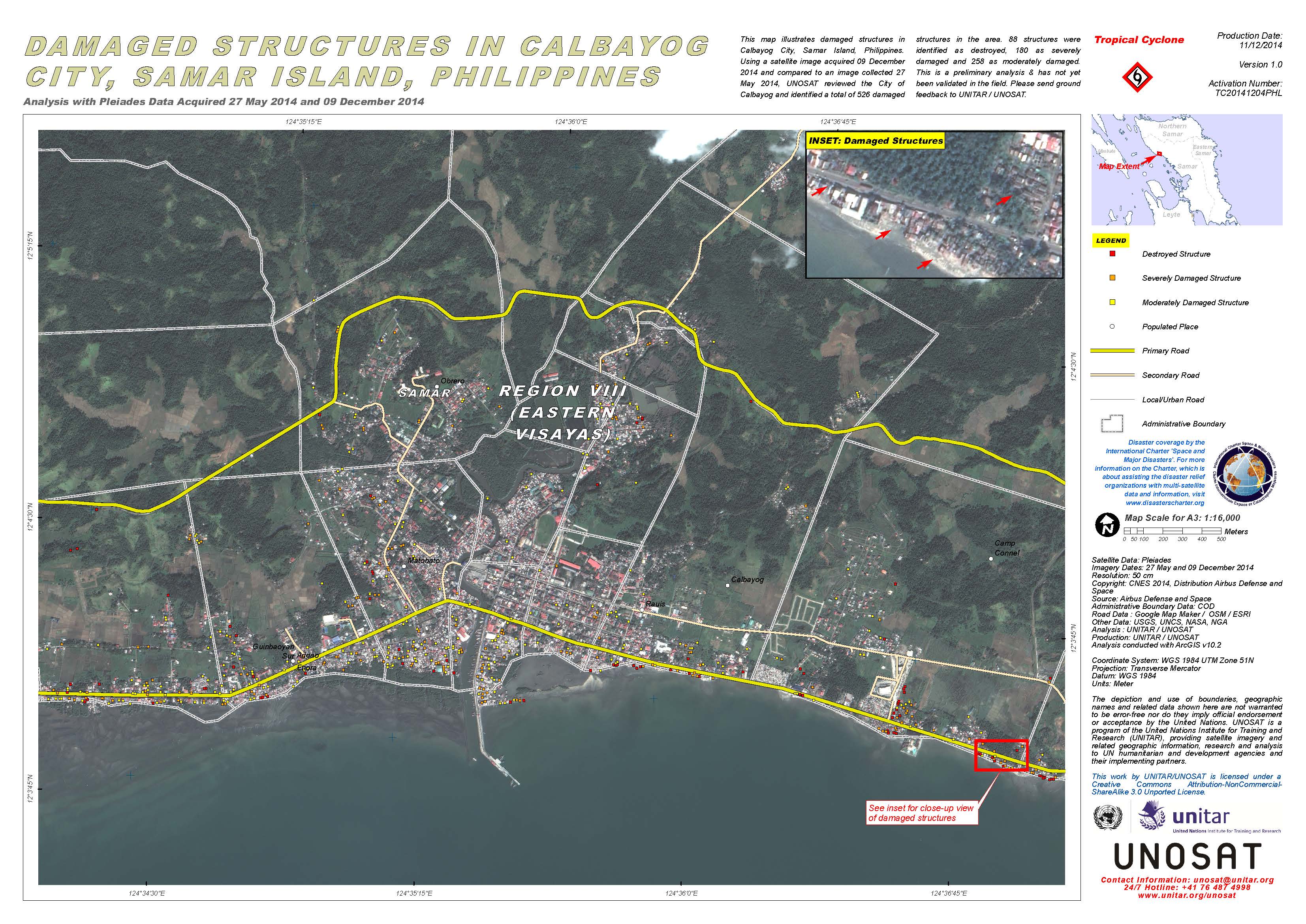
Damaged structures in Calbayog City, Samar Island, in the Philippines
Авторские права: Pleiades © CNES 2014 - Distribution: Airbus Defence and Space, all rights reserved
Map produced by UNITAR/UNOSAT
Information about the Product
Получено: Pre-disaster: 27/05/2014
Post-disaster: 09/12/2014
Источник: Pleiades
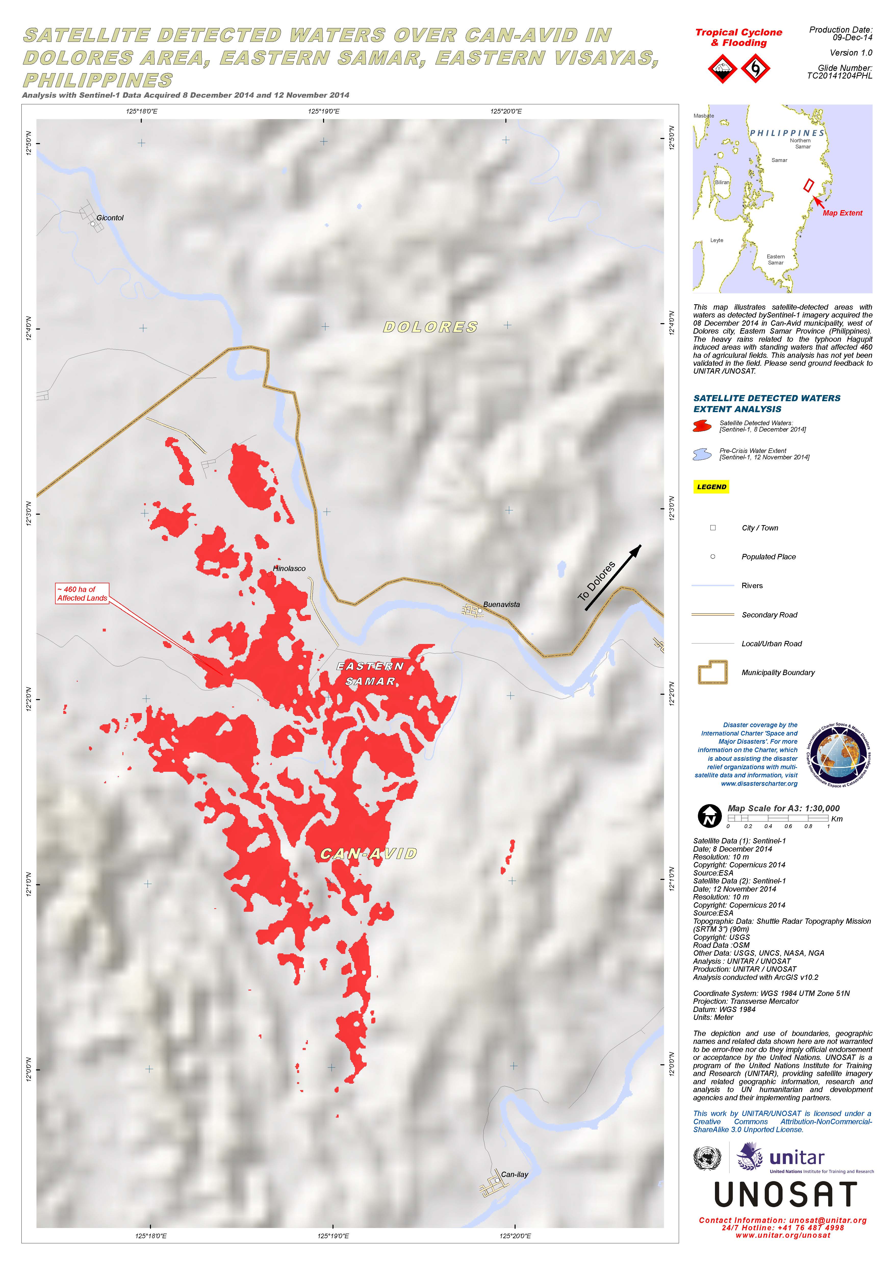
Satellite detected waters over Can-Avid in the Dolores area of Eastern Samar, in the Eastern Visayas region of the Philippines
Авторские права: Copernicus 2014 / ESA
Map produced by UNITAR/UNOSAT
Information about the Product
Получено: Pre-disaster: 12/11/2014
Post-disaster: 08/12/2014
Источник: Sentinel-1
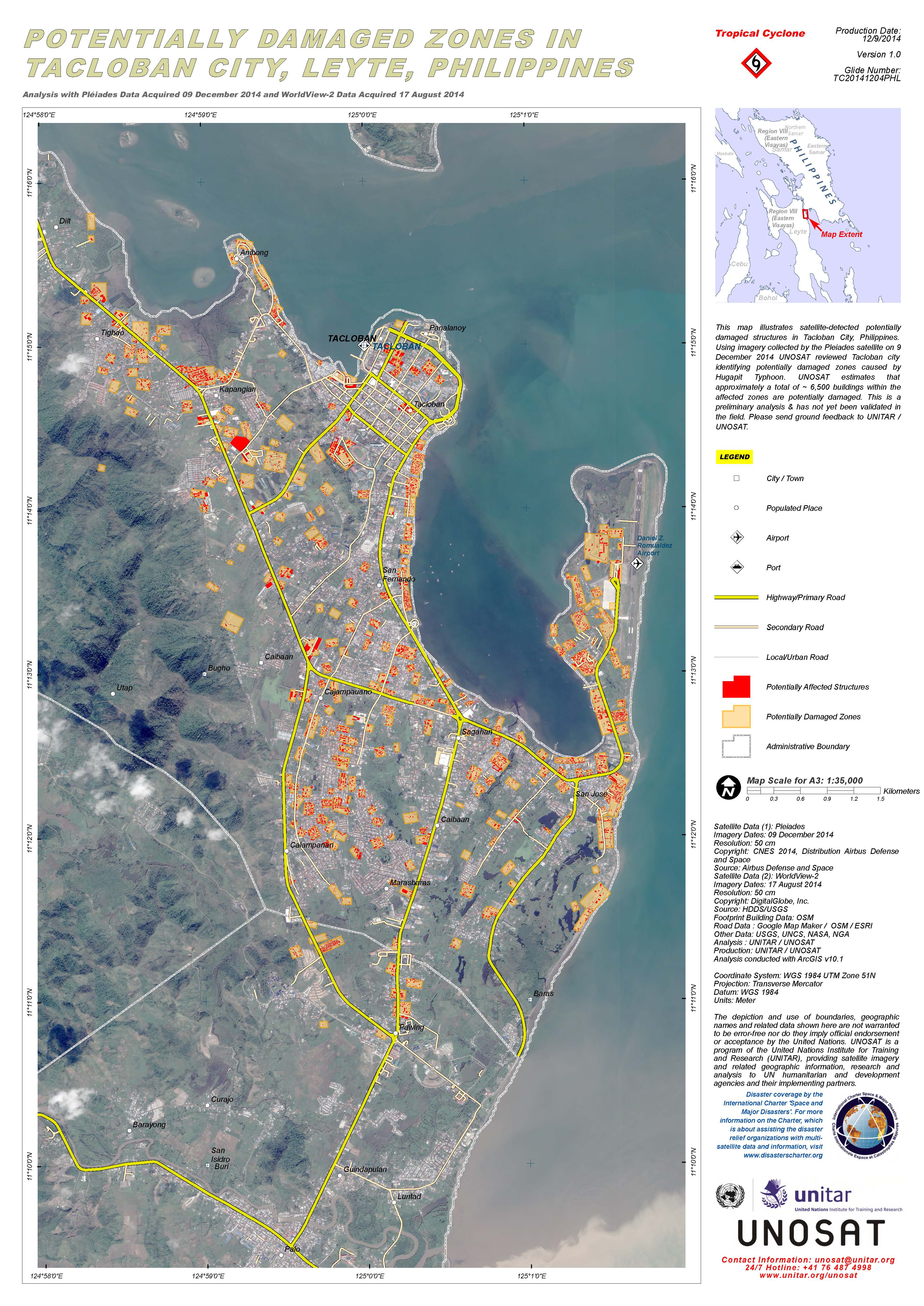
Potentially damaged zones in Tacloban City, Leyte, in the Philippines after Typhoon Hagupit
Авторские права: Pleiades © CNES 2014 - Distribution: Airbus Defence and Space, all rights reserved
WorldView-2 © DigitalGlobe Inc.
Map produced by UNITAR/UNOSAT
Information about the Product
Получено: Pleiades: 09/12/2014
WorldView-2: 17/08/2014
Источник: Pleiades / WorldView-2
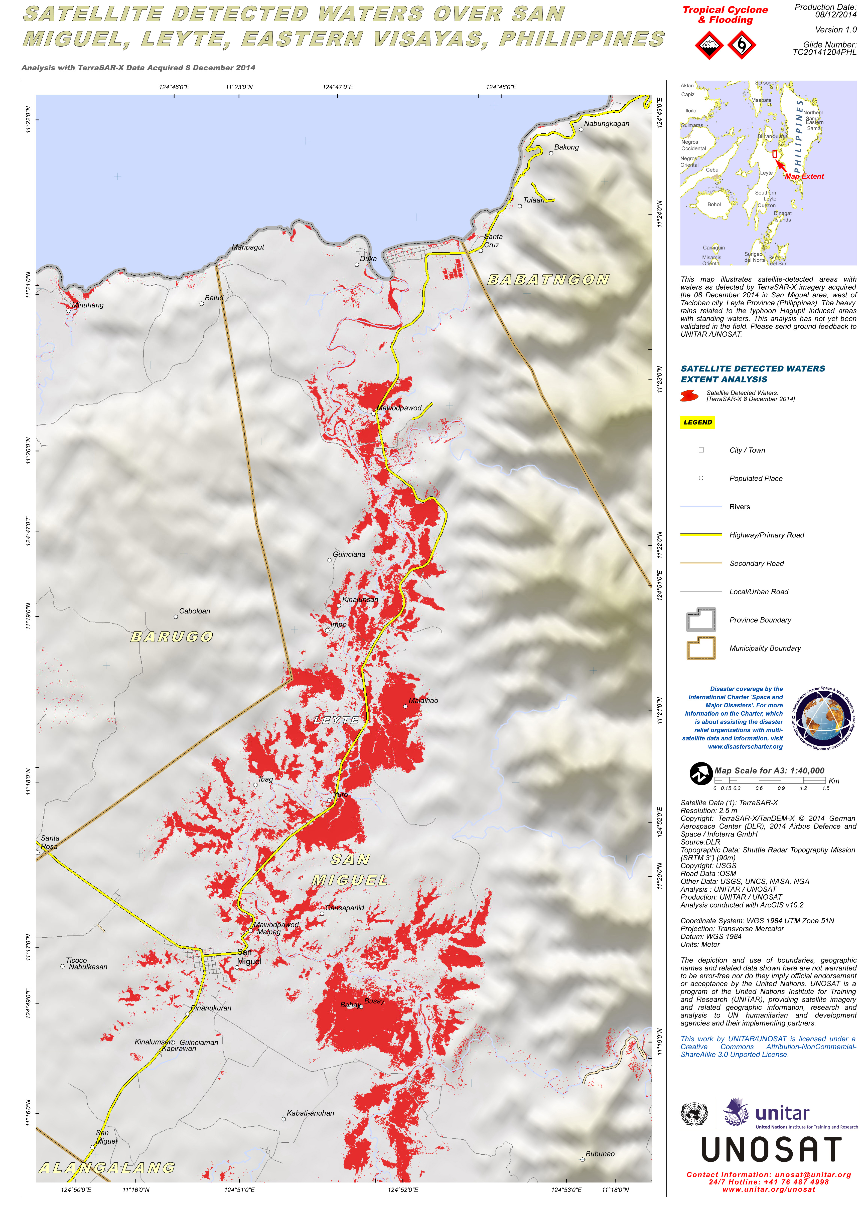
Map illustrating satellite-detected areas with waters as detected by TerraSAR-X imagery acquired over the San Miguel area, west of Tacloban city, Leyte Province in the Philippines.
Авторские права: TerraSAR-X © German Aerospace Center (DLR), 2014 Airbus Defence and Space / Infoterra GmbH
SRTM 3 © USGS
Map produced by UNITAR/UNOSAT
Information about the Product
Получено: 08/12/2014
Источник: TerraSAR-X / SRTM
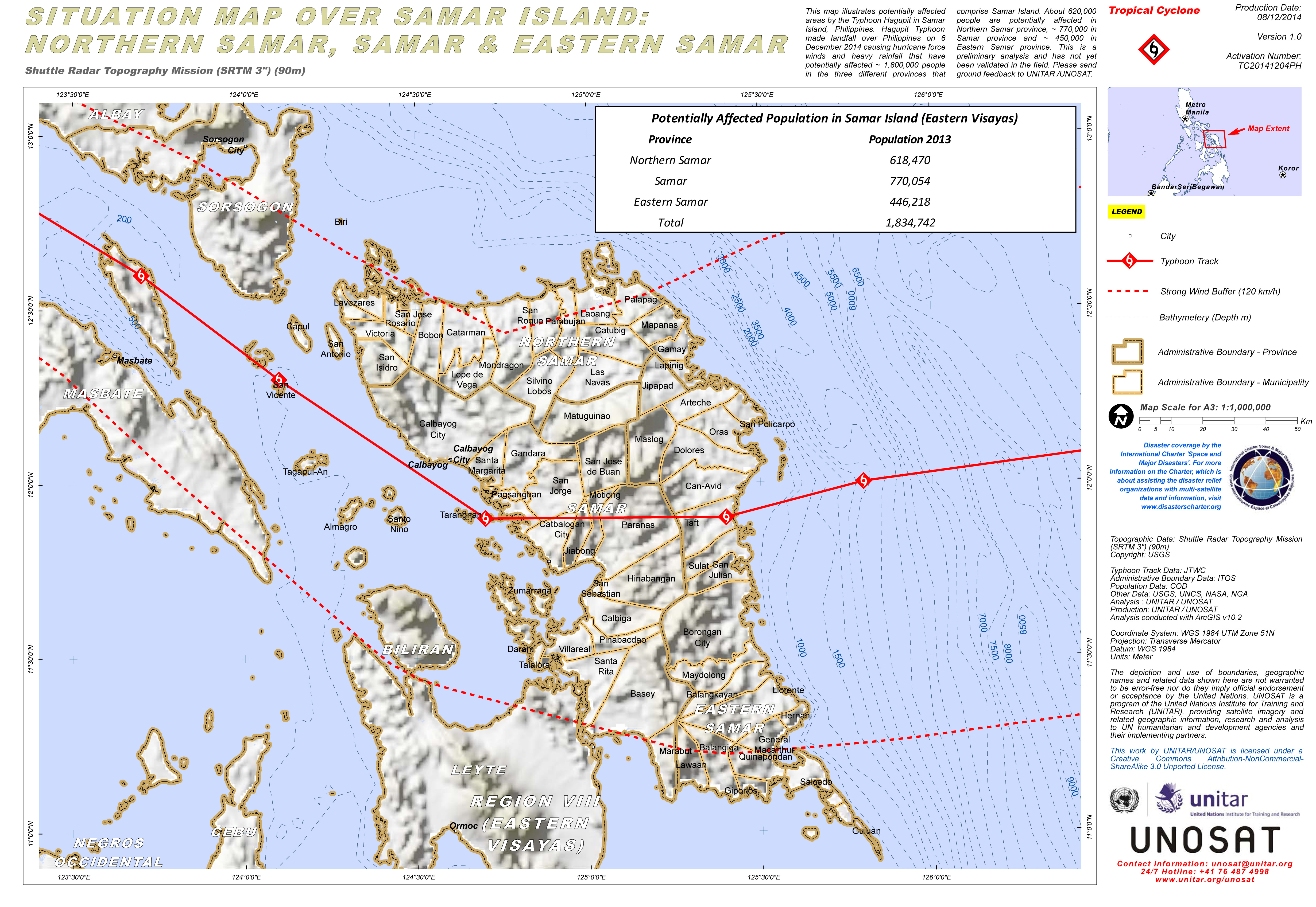
Situation map illustrating potentially affected areas of Samar Island, in the Philippines, by Typhoon Hagupit.
Авторские права: USGS
Map produced by UNITAR/UNOSAT
Information about the Product
Источник: SRTM 3
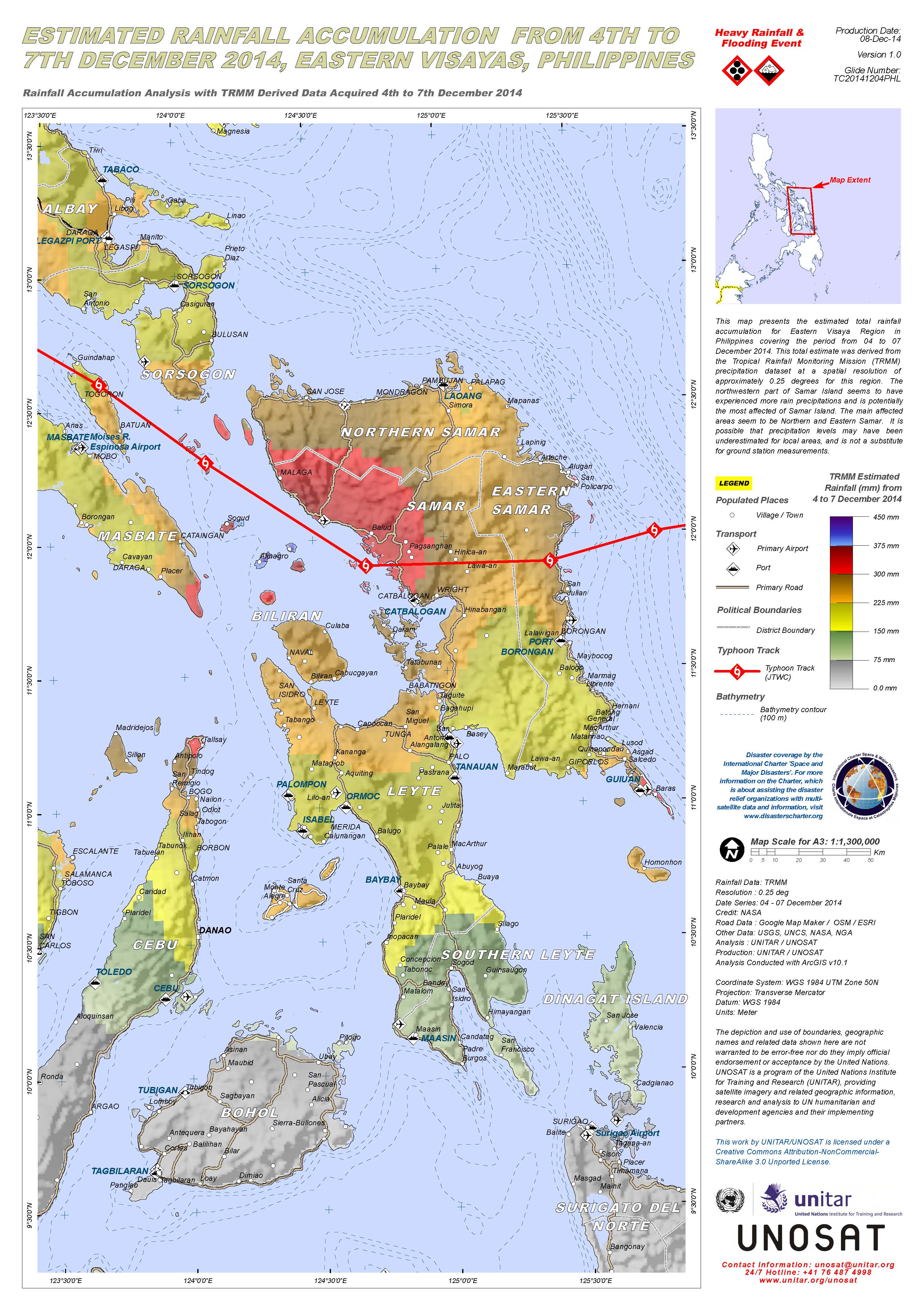
Estimated rainfall accumulation from Typhoon Hagupit over Eastern Visayas, the Philippines
Авторские права: NASA
Map produced by UNITAR/UNOSAT
Information about the Product
Получено: 04/12/2014-07/12/2014
Источник: TRMM
 Вернуться к полному архиву активаций

