 English
 Spanish
 French
 Chinese
 Russian
 Portuguese
 Последняя Активация
Charter activations
Flood in Colombia
Heavy rain caused three rivers to burst their banks in Colombia on 1 April 2017. The flood waters swept into the city of Mocoa, bringing mud and debris surging through the streets and flattening entire neighbourhoods.
Mocoa is located in southern Colombia, in the Andes Mountains. The mountainous terrain makes landslides a common occurrence in this region, but the damage to Mocoa has been described as the worst the city has experienced on record. Much of the city is covered with mud, rocks and trees drawn along by the flood.
A state of emergency has been declared and search efforts are ongoing to find any survivors buried under the mud and debris. More than 200 people are still missing and over 500 were left homeless, but the Colombian President has announced a commitment to helping all of those affected by the disaster and to rebuild parts of the city which were destroyed.
| Тип события: | Flood |
| Место события: | Colombia |
| Date of Charter Activation: | 01 April 2017 |
| Время активации Хартии: | 19:30:00 |
| TЧасовой пояс в районе активации Хартии: | UTC+02:00 |
| Запрос на активацию поступил от: | National Unit for Disaster Risk Management (UNGRD) / Unidad Nacional para la Gestión del Riesgo de Desastres, IDEAM |
| Номер активации: | 524 |
| Менеждер проекта от: | ESA |
Products
Animation of Landslide and Debris Flow Detection in Mocoa
Авторские права: RapidEye data © Planet Labs Inc. (2017) - All rights reserved
Map produced by Remote Sensing Section, Helmholtz Centre Potsdam - GFZ German Research Centre for Geosciences
Information about the Product
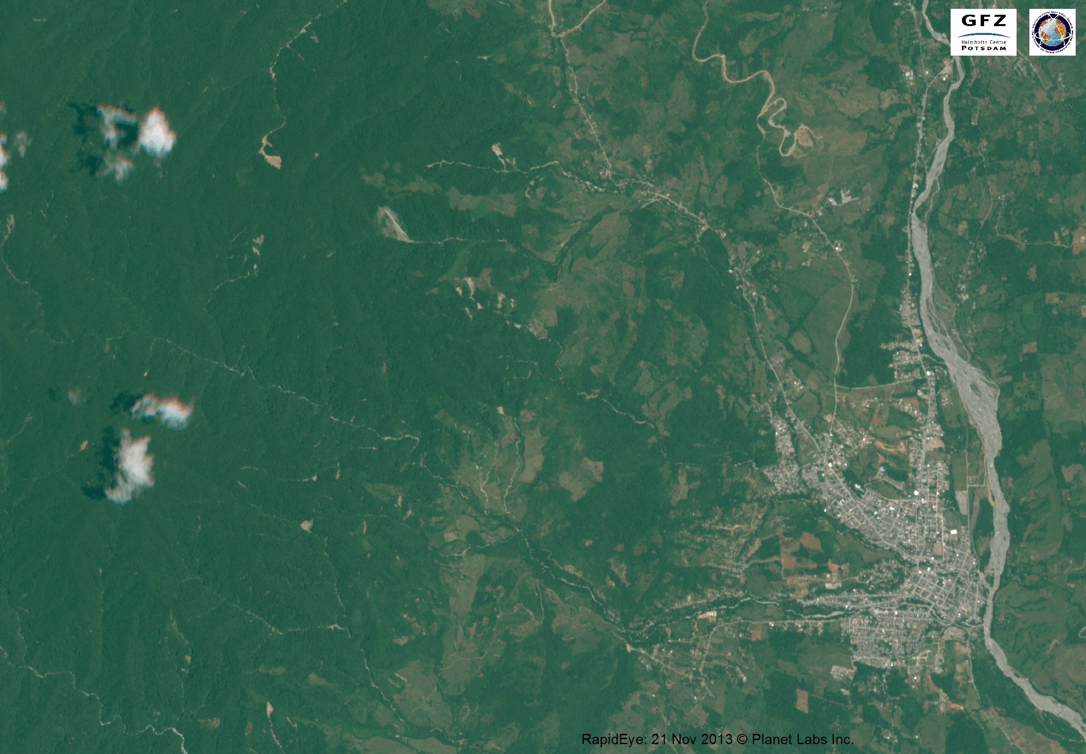
Получено: Before-image: 21/11/2013
After-image: 10/04/2017
Источник: RapidEye
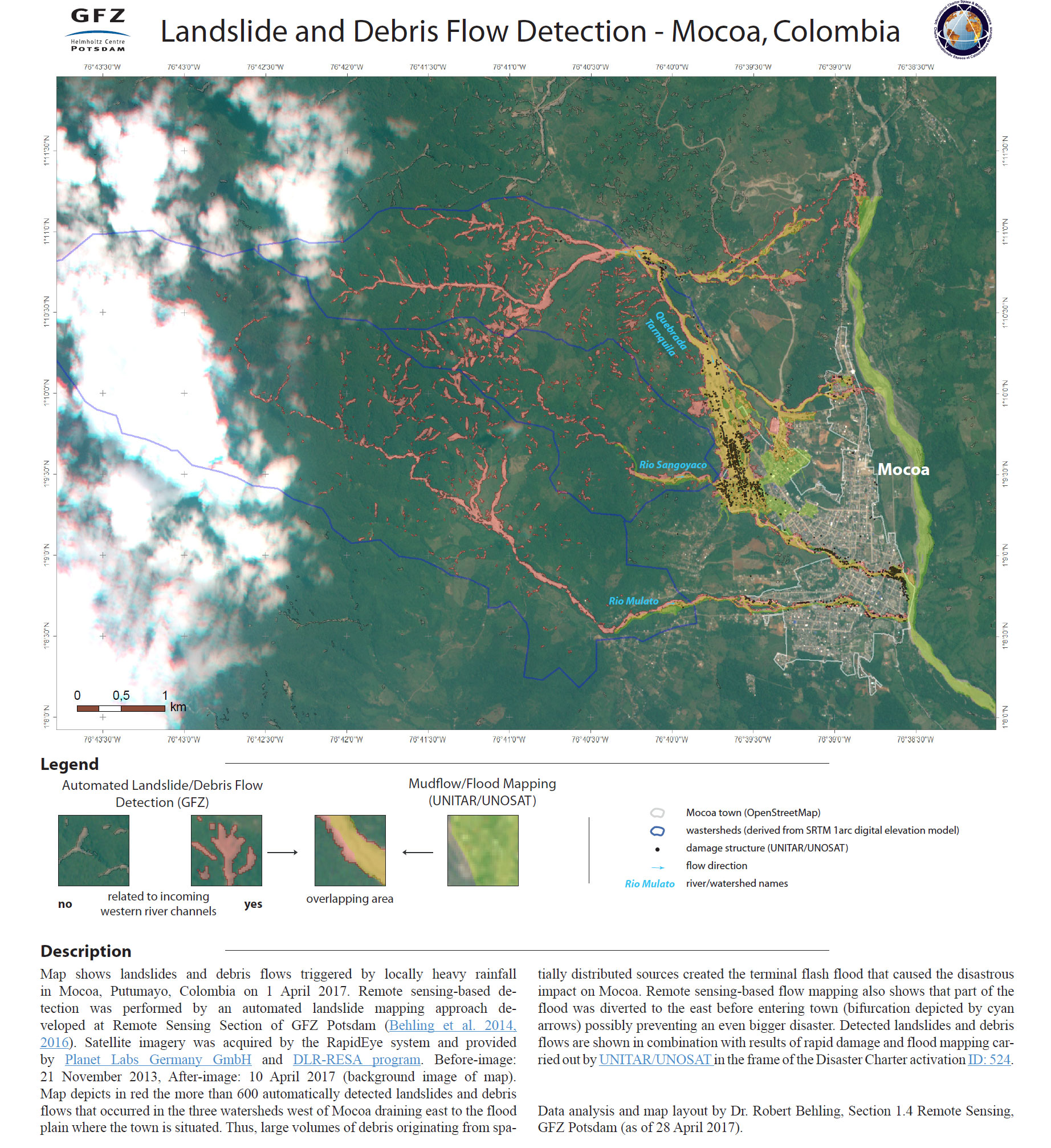
Automated landslide and debris flow detection in Mocoa
Download a PDF version of this map
Авторские права: RapidEye data © Planet Labs Inc. (2017) - All rights reserved
Map produced by Remote Sensing Section, Helmholtz Centre Potsdam - GFZ German Research Centre for Geosciences
Information about the Product
Получено: Before-image: 21/11/2013
After-image: 10/04/2017
Источник: RapidEye
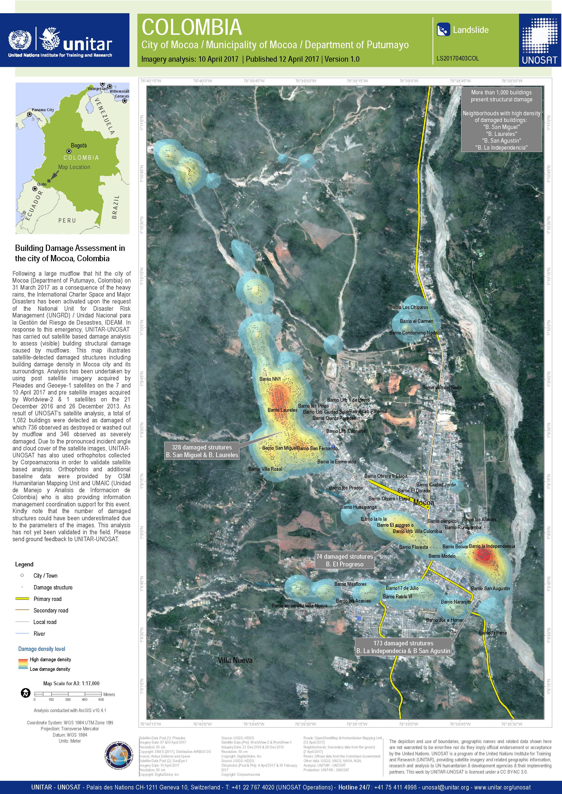
Damage assessment of buildings in Mocoa
Авторские права: Pleiades © CNES (2017) - Distribution: Airbus Defence and Space, all rights reserved
GeoEye-1, WorldView-1 and WorldView-2 © DigitalGlobe Inc.
Map produced by UNITAR/UNOSAT
Information about the Product
Получено: Pleiades: 07/04/2017 and 10/04/2017
GeoEye-1: 10/04/2017
WorldView-1: 26/12/2013
WorldView-2: 21/12/2016
Источник: Pleiades / GeoEye-1 / WorldView-1 and -2
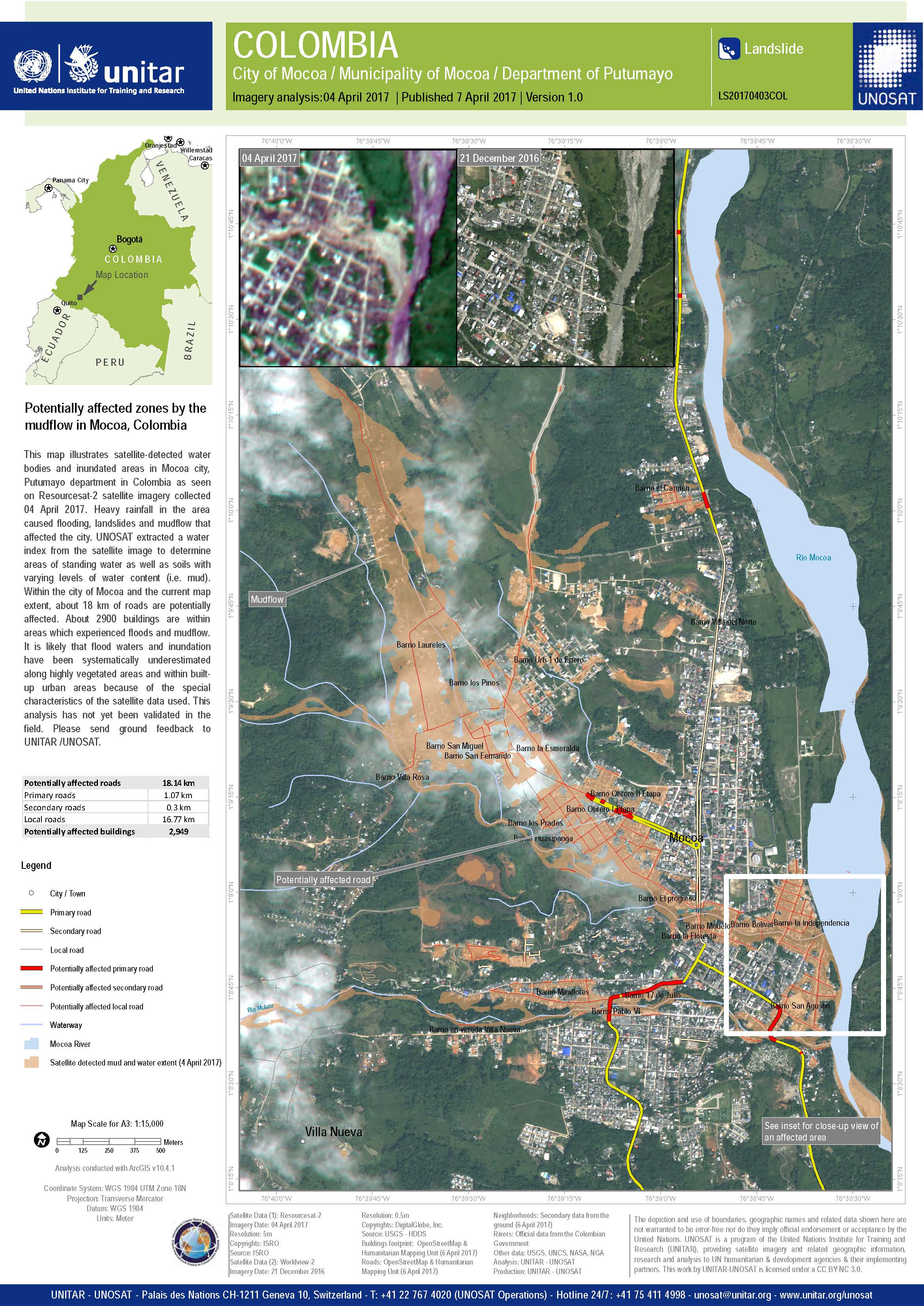
Areas potentially affected by the mudflow in Mocoa
Авторские права: ResourceSat-2 data and products © ISRO (2017) - All rights reserved
WorldView-3 © DigitalGlobe Inc.
Map produced by UNITAR/UNOSAT
Information about the Product
Получено: ResourceSat-2: 04/04/2017
WorldView-2: 21/12/2016
Источник: ResourceSat-2 / WorldView-2
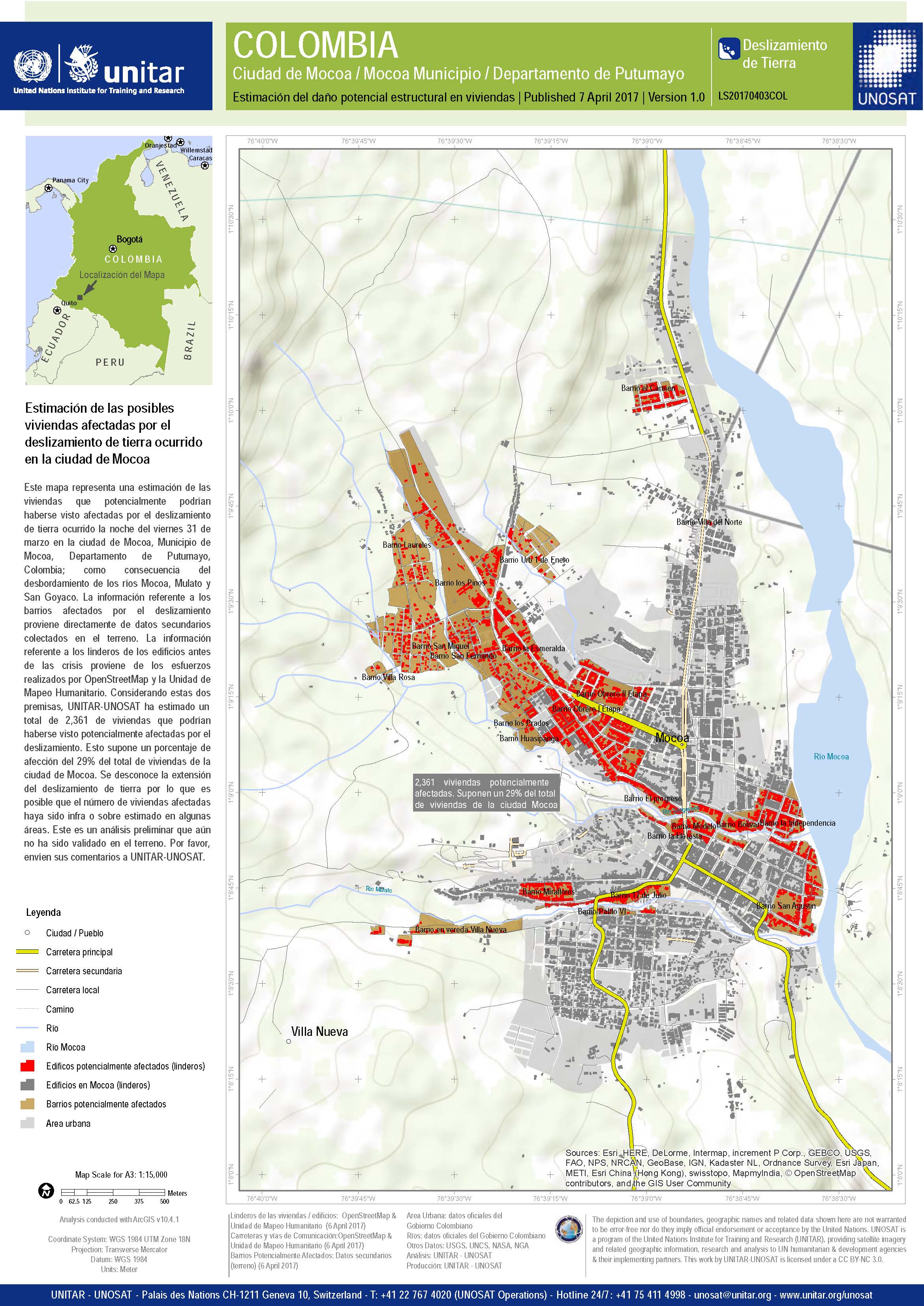
Estimated damage to buildings in Mocoa following the landslide
Авторские права: Map produced by UNITAR/UNOSAT
Information about the Product
Получено: 06/04/2017
Источник: OpenStreetMap & Humanitarian Mapping Unit and ground data from authorities
 Вернуться к полному архиву активаций

