 English
 Spanish
 French
 Chinese
 Russian
 Portuguese
 Последняя Активация
Charter activations
Earthquake in Philippines
A powerful 6.8 magnitude undersea earthquake rocked the Philippines in the afternoon of 17 November. The epicentre of the earthquake was located 26 kilometres (16 miles) from Burias at the southern tip of the Philippines.
Although initially logged as having a magnitude of 7.2, the Philippine Institute of Volcanology and Seismology (PHIVOLCS) later downgraded the earthquake to 6.8. At least 11 people were killed while 730 others were injured and authorities reported that more than 1,500 households were impacted and damaged.
There was no tsunami warning issued, but residents were advised to be on alert for aftershocks which can cause more serious damage.
The Philippines lies on the "Ring of Fire", a belt of volcanoes circling the Pacific Ocean that is prone to earthquakes.
| Тип события: | Earthquake |
| Место события: | Philippines |
| Date of Charter Activation: | 2023-11-18 |
| Время активации Хартии: | 09:10 |
| TЧасовой пояс в районе активации Хартии: | UTC+09:00 |
| Запрос на активацию поступил от: | ADRC on behalf of PHIVOLCS |
| Номер активации: | 850 |
| Менеждер проекта от: | Abigail Pidlaoan (Philippine Institute of Volcanology and Seismology (PHIVOLCS)) |
| act-value-adders: | Dalia Laoubi (CSA) |
Products
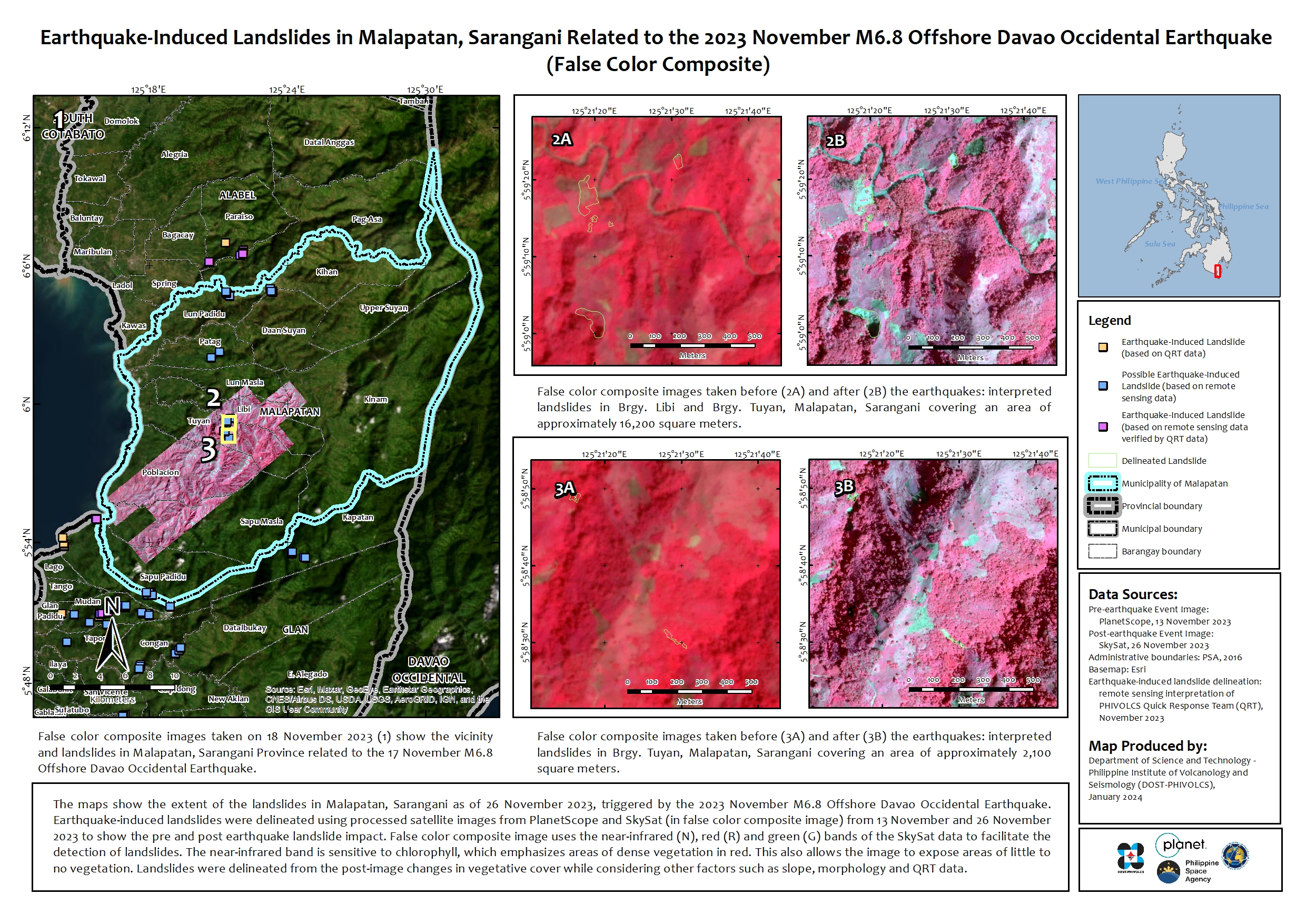
Earthquake-Induced Landslides in Malapatan, Sarangani Related to the 2023 November M6.8 Offshore Davao Occidental Earthquake (False Color Composite)
Авторские права: © Planet Labs Inc. (2023)
Philippine Copyright 2024 by the PhilSA
Map produced by the department of Science and Technology - Philippine Institute of Volcanology and Seismology (DOST-PHIVOLCS)
Information about the Product
Получено: PlanetScope: 13/11/2023
SkySat: 26/11/2023
Источник: PlanetScope / SkySat
Категория: Delineation Map
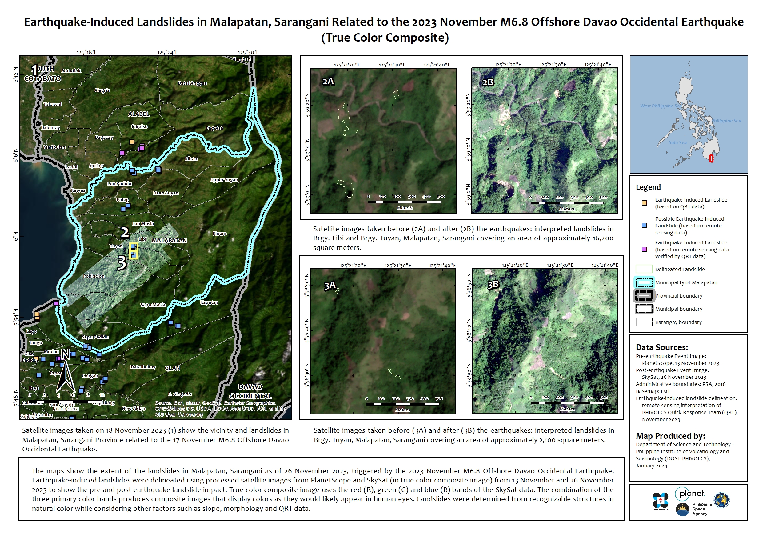
Earthquake-Induced Landslides in Malapatan, Sarangani Related to the 2023 November M6.8 Offshore Davao Occidental Earthquake (True Color Composite).
Авторские права: © Planet Labs Inc. (2023)
Philippine Copyright 2024 by the PhilSA
Map produced by the department of Science and Technology - Philippine Institute of Volcanology and Seismology (DOST-PHIVOLCS)
Information about the Product
Получено: PlanetScope: 13/11/2023
SkySat: 26/11/2023
Источник: PlanetScope / SkySat
Категория: Delineation Map
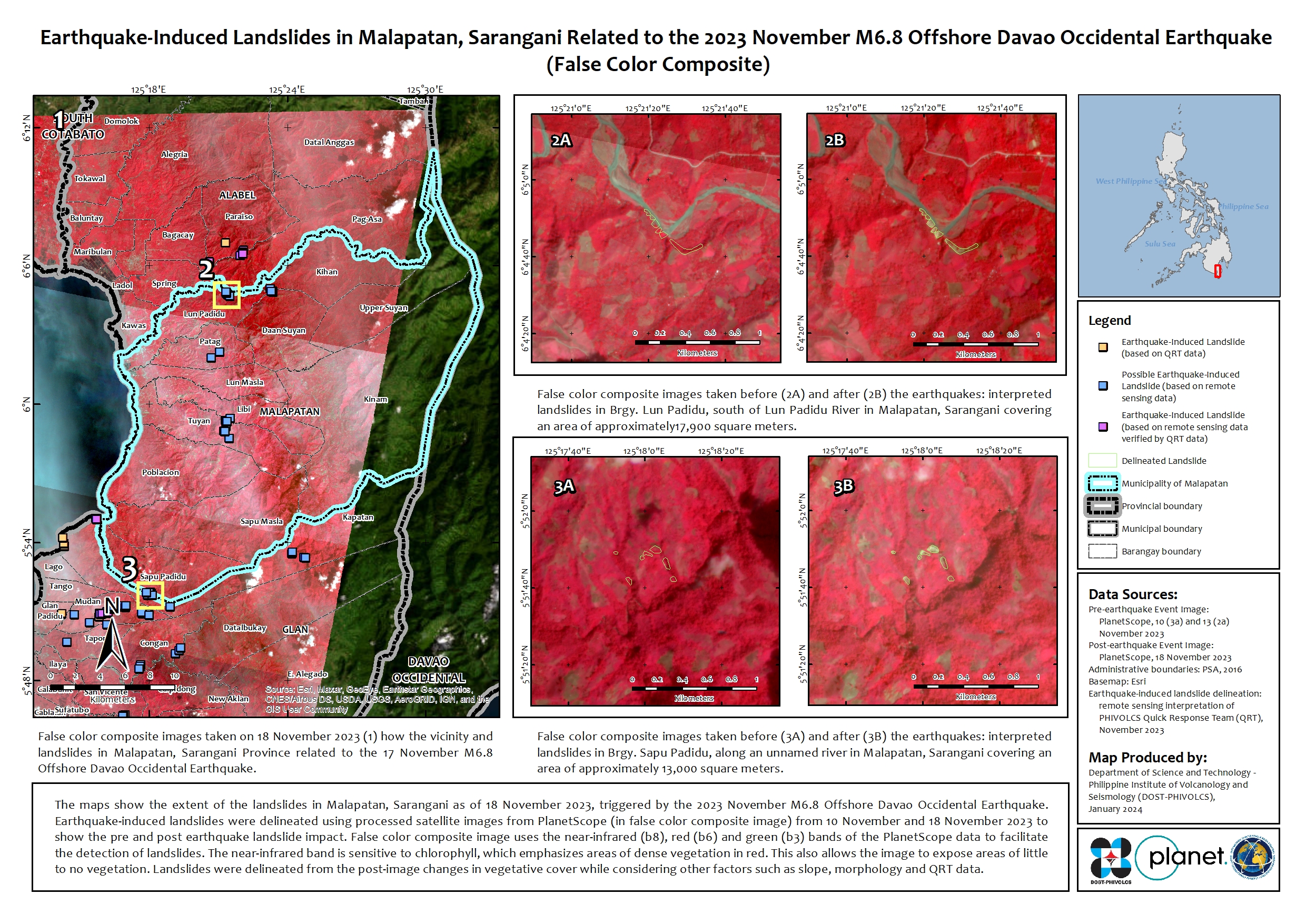
Earthquake-Induced Landslides in Malapatan, Sarangani Related to the 2023 November M6.8 Offshore Davao Occidental Earthquake (False Color Composite)
Авторские права: © Planet Labs Inc. (2023)
Map produced by the department of Science and Technology - Philippine Institute of Volcanology and Seismology (DOST-PHIVOLCS)
Information about the Product
Получено: PlanetScope: 18/11/2023
Источник: PlanetScope
Категория: Delineation Map
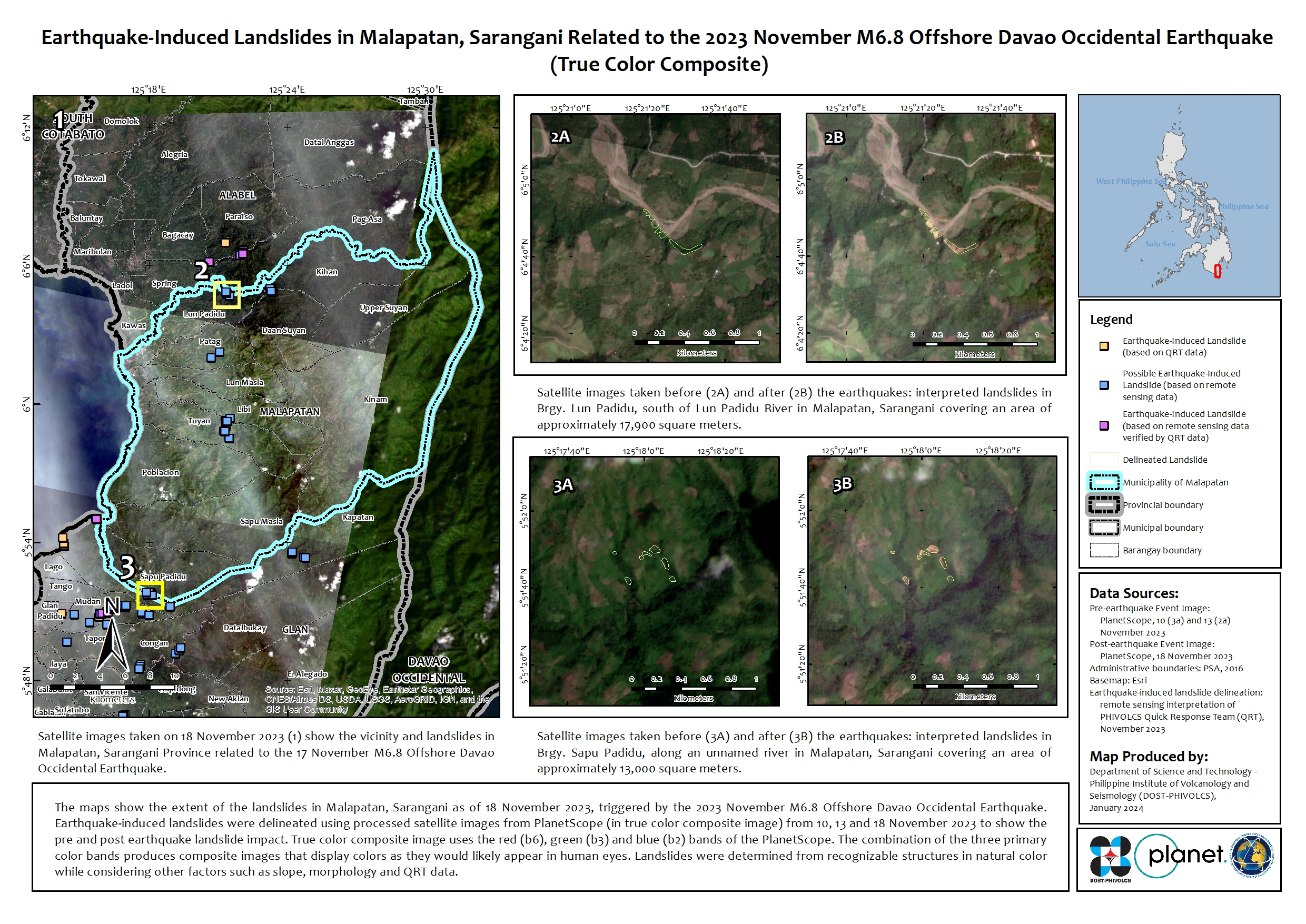
Earthquake-Induced Landslides in Malapatan, Sarangani Related to the 2023 November M6.8 Offshore Davao Occidental Earthquake (True Color Composite)
Авторские права: © Planet Labs Inc. (2023)
Map produced by the department of Science and Technology - Philippine Institute of Volcanology and Seismology (DOST-PHIVOLCS)
Information about the Product
Получено: PlanetScope: 18/11/2023
Источник: PlanetScope
Категория: Delineation Map
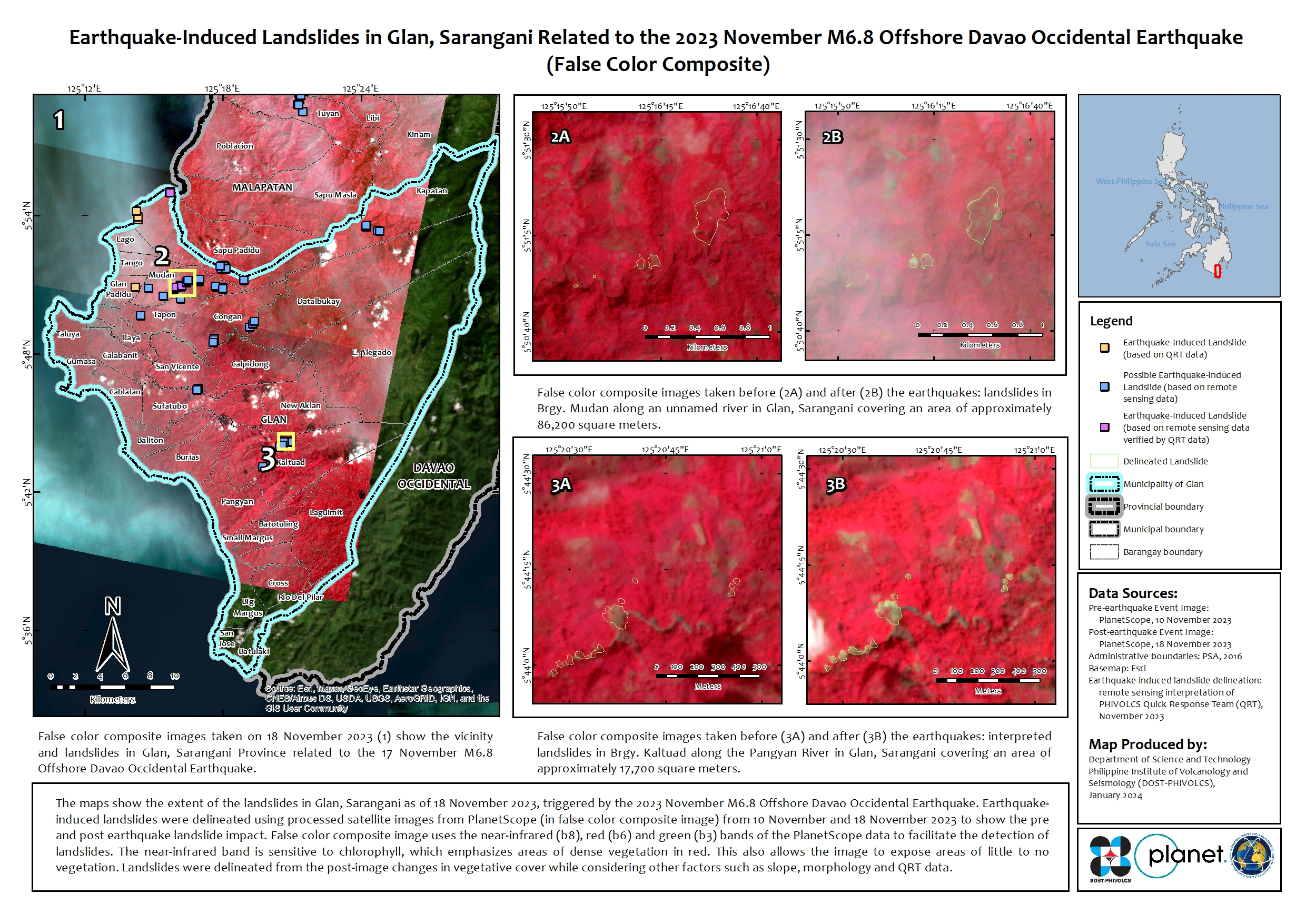
Earthquake-Induced Landslides in Glan, Sarangani Related to the 2023 November M6.8 Offshore Davao Occidental Earthquake (False Color Composite)
Авторские права: © Planet Labs Inc. (2023)
Map produced by the department of Science and Technology - Philippine Institute of Volcanology and Seismology (DOST-PHIVOLCS)
Information about the Product
Получено: PlanetScope: 18/11/2023
Источник: PlanetScope
Категория: Delineation Map
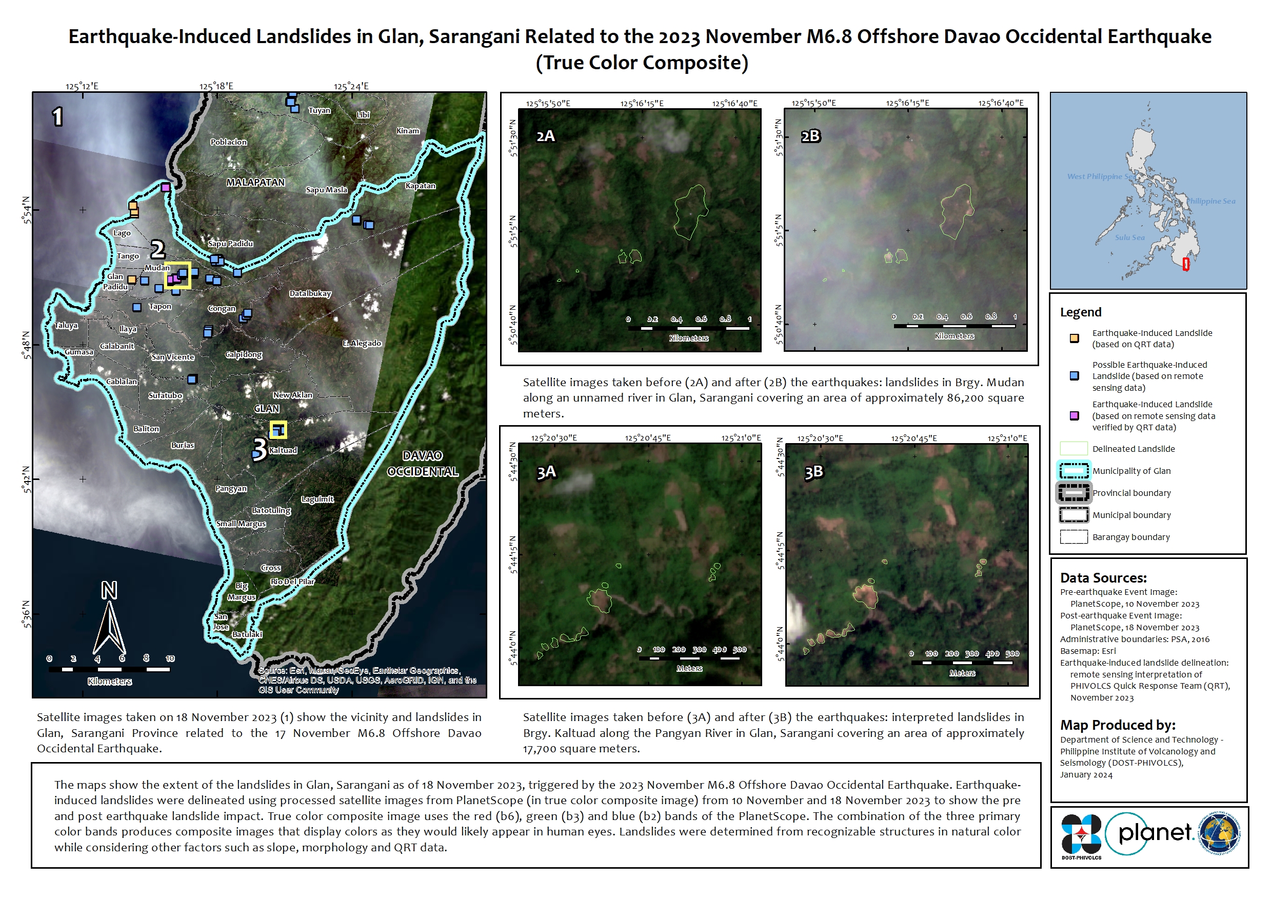
Earthquake-Induced Landslides in Glan, Sarangani Related to the 2023 November M6.8 Offshore Davao Occidental Earthquake (True Color Composite)
Авторские права: © Planet Labs Inc. (2023)
Map produced by the department of Science and Technology - Philippine Institute of Volcanology and Seismology (DOST-PHIVOLCS)
Information about the Product
Получено: PlanetScope: 18/11/2023
Источник: PlanetScope
Категория: Delineation Map
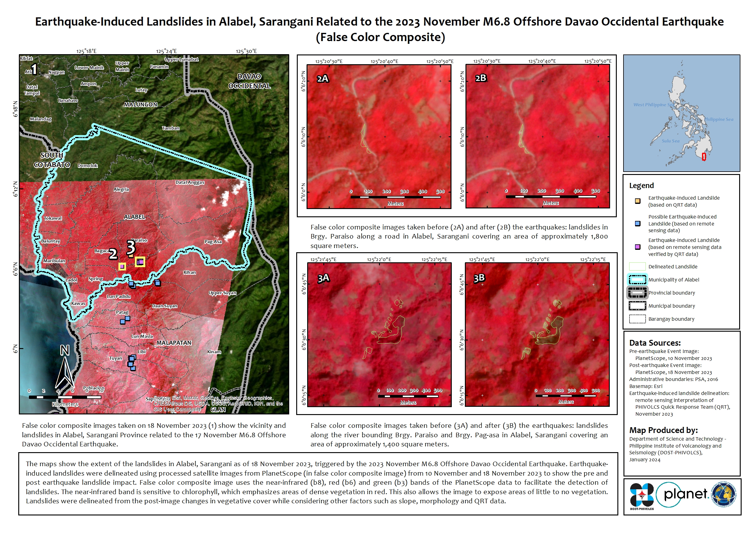
Earthquake-Induced Landslides in Alabel, Sarangani Related to the 2023 November M6.8 Offshore Davao Occidental Earthquake (False Color Composite)
Авторские права: © Planet Labs Inc. (2023)
Map produced by the department of Science and Technology - Philippine Institute of Volcanology and Seismology (DOST-PHIVOLCS)
Information about the Product
Получено: PlanetScope: 19/11/2023
Источник: PlanetScope
Категория: Delineation Map
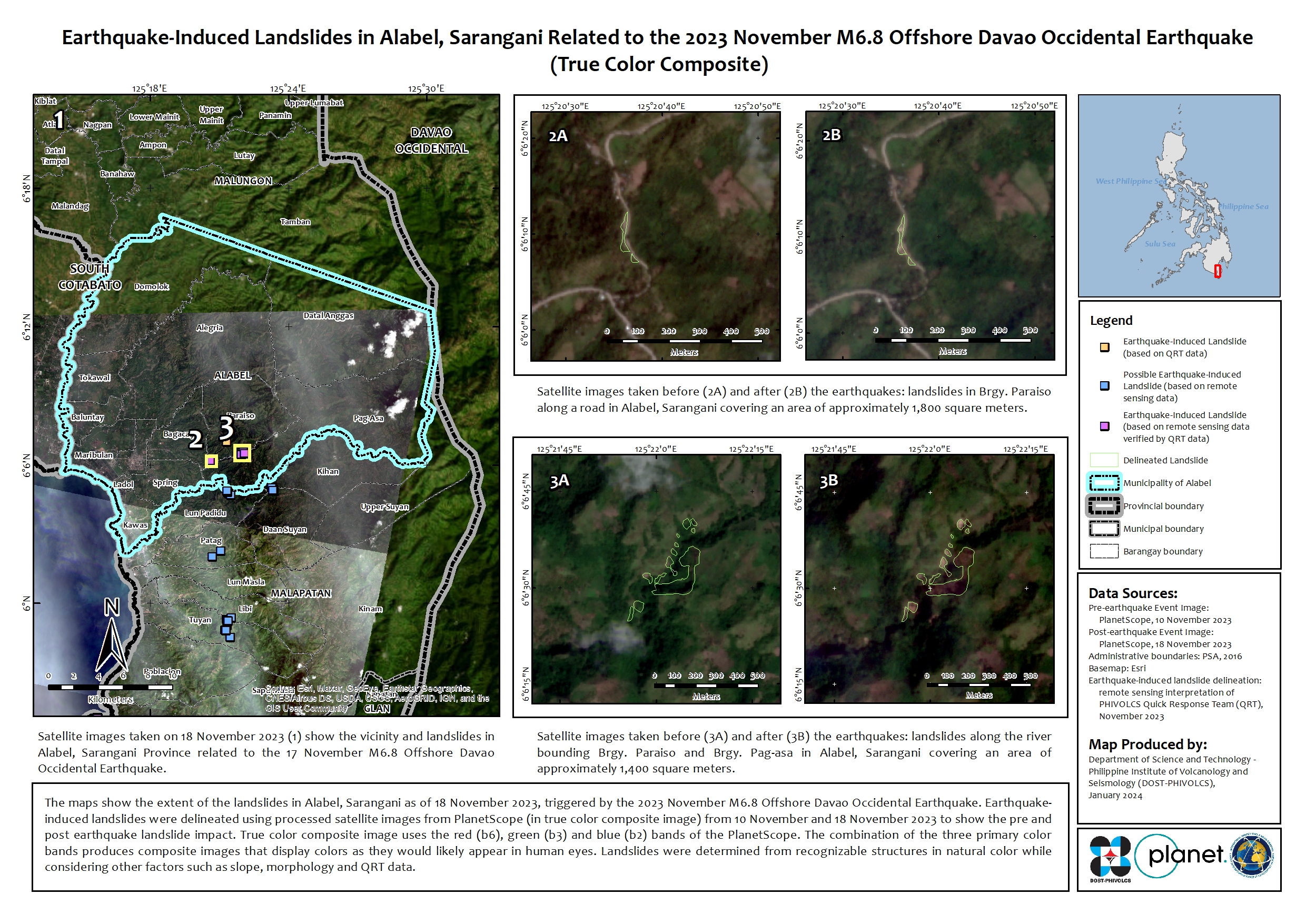
Earthquake-Induced Landslides in Alabel, Sarangani Related to the 2023 November M6.8 Offshore Davao Occidental Earthquake (True Color Composite).
Авторские права: © Planet Labs Inc. (2023)
Map produced by the department of Science and Technology - Philippine Institute of Volcanology and Seismology (DOST-PHIVOLCS)
Information about the Product
Получено: 18/11/2023
Источник: PlanetScope
Категория: Delineation Map
 Вернуться к полному архиву активаций

