 English
 Spanish
 French
 Chinese
 Russian
 Portuguese
 Latest Activation
Charter activations
Tropical Storm Nalgae in the Philippines
Tropical Storm Nalgae (known as Paeng in the Philippines) unleashed floods and landslides in the Philippines, killing at least 45 people.
Provinces and cities in the south were hit the hardest by the storm. The Bangsamoro Autonomous Region in Muslim Mindanao (BARMM) was put under a state of emergency due to severe flooding.
Authorities reported that close to 185,000 people across the country were affected by the storm.
Related News and Resources
| Tipo de evento: | Ocean Storm |
| Local do evento: | Philippines |
| Data da Ativação da Carta: | 2022-10-29 |
| Tempo de Ativação da Carta: | 22:22 |
| Zona de Tempo da Ativação da Carta: | UTC+05:30 |
| Requisitante da Carta: | UNOOSA/UN-SPIDER on behalf of Philippines Space Agency on behalf of the National Disaster Risk Reduction and Managment Council (NDRRMC) |
| ID da Ativação: | 789 |
| Gerenciamento de projeto: | Chathumal Madhuranga (Asia Institute of Technology) |
| act-value-adders: | Shielo Muta (PhilSA Space Mission Control and Operations Division) Konstantin Homenkov (Geoniformation systems) Jakrapong Tawala (UNITAR) |
Products
Landslides and Mud-flows in Maguindanao province Philippines 3
Direitos autorais: Contains modified Copernicus Sentinel data (2022)
Includes Pleiades material © CNES (2022), Distribution Airbus DS.
Map produced by GIC AIT
Information about the Product
Adquirida: Sentinel-2: 01/05/2022
Pleiades: 08/11/2022
Fonte: Sentinel-2 / Pleiades
Categoria: Reference Map
Landslides and Mud-flows in Maguindanao province Philippines 2
Direitos autorais: Contains modified Copernicus Sentinel data (2022)
Includes Pleiades material © CNES (2022), Distribution Airbus DS.
Map produced by GIC - AIT
Information about the Product
Adquirida: Sentinel-2: 01/05/2022
Pleiades: 08/11/2022
Fonte: Sentinel-2 / Pleiades
Categoria: Reference Map
Landslides and Mud-flows in Maguindanao province Philippines 1
Direitos autorais: Contains modified Copernicus Sentinel data (2022)
Includes Pleiades material © CNES (2022), Distribution Airbus DS.
Map produced by GIC-AIT
Information about the Product
Adquirida: Sentinel-2: 01/05/2022
Pleiades: 08/11/2022
Fonte: Sentinel-2 / Pleiades
Categoria: Reference Map
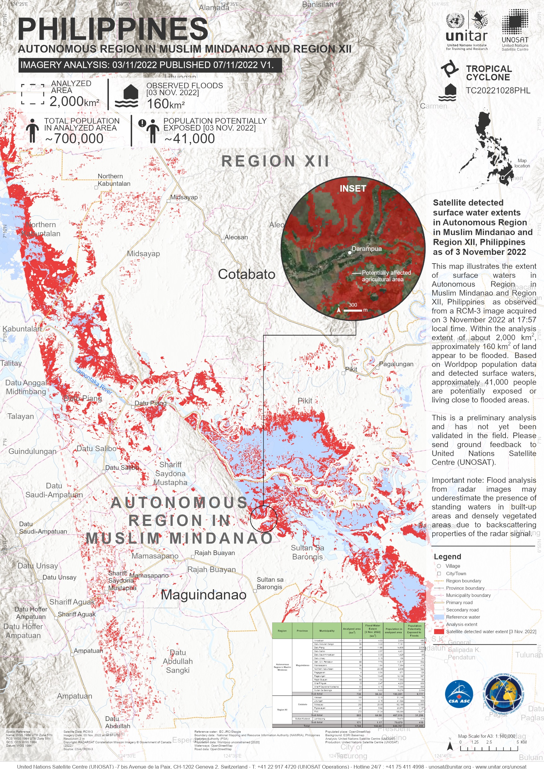
Satellite detected surface water extents in Autonomous Region in Muslim Mindanao and Region XII, Philippines
Direitos autorais: RADARSAT Constellation Mission Imagery © Government of Canada (2022) - RADARSAT is an official mark of the Canadian Space Agency
Map produced by UNITAR / UNOSAT
Information about the Product
Adquirida: 03/11/2022
Fonte: RCM
Categoria: Delineation Map
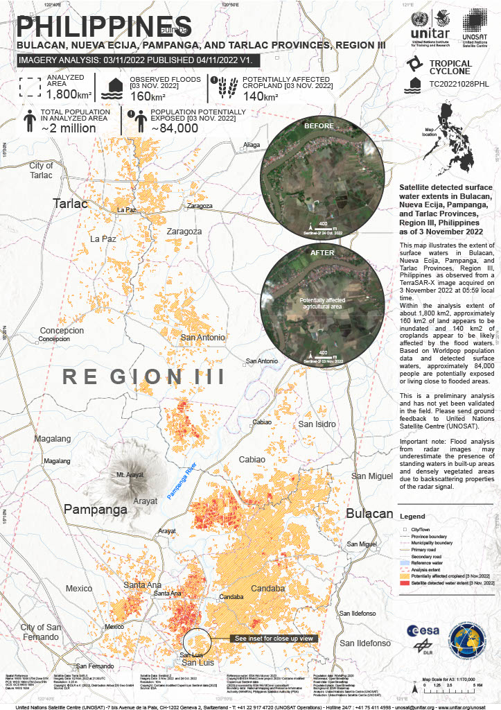
Satellite detected surface water extent in Bulacan, Nueva Ecija, Pampanga, and Tarlac Provinces, Region III, Philippines
Direitos autorais: © DLR e.V. (2022), Distribution Airbus DS Geo GmbH
Map produced by UNITAR / UNOSAT
Information about the Product
Adquirida: 02/11/2022
Fonte: TerraSAR-X
Categoria: Delineation Map

Flooding in Maguindanao province, the Philippines
Direitos autorais: WorldView-2 © (2022) DigitalGlobe, Inc., Longmont CO USA 80503. DigitalGlobe and the DigitalGlobe logos are trademarks of DigitalGlobe, Inc. The use and/or dissemination of this data and/or of any product in any way derived there from are restricted. Unauthorized use and/or dissemination is prohibited
Includes Pleiades material © CNES (2022), Distribution Airbus DS.
Map produced by GIC-AIT
Information about the Product
Adquirida: WorldView-2: 12/09/2022
Pleiades: 01/11/2022
Fonte: WorldView-2 / Pleiades
Categoria: Reference Map
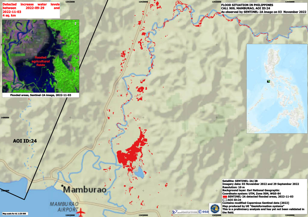
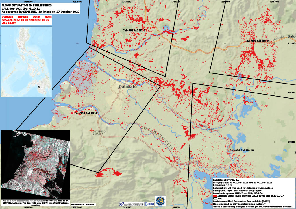
Flood situation in Philippines
Direitos autorais: Contains modified Copernicus Sentinel data (2022)
USGS/NASA Landsat Program
Map produced by Geo-Information Systems
Information about the Product
Adquirida: Sentinel-1 27/10/2022, Landsat 9: 30/10/2022
Fonte: Sentinel-1, Landsat 9
Categoria: Delineation Monitoring Maps
 Voltar ao arquivo completo da Ativação

