 English
 Spanish
 French
 Chinese
 Russian
 Portuguese
 Latest Activation
Charter activations
Cyclone Biparjoy in India
Cyclone Biparjoy, India's first severe cyclone of the year, made landfall in Western India near the Pakistan border on Thursday 15 June 2023.
The Cyclone was initially classified as a very severe cyclonic storm however the IMD have since reduced this classification to severe.
The India Meteorological Department (IMD) issued an orange alert for the Saurashtra and Kutch coasts in Gujarat prior to the disaster as the storm was predicted to cross the Jakhau Port area. The port was the first to be hit with winds of up to 125 km/h (78 mph) on 15 June. The storm weakened once it reached the Gujarat state however it continues to move across the state taking strong wind and rain with it.
Currently, two people have been reported as deceased and 22 injured. Vegetation, infrastructure and transport links have all been destroyed but the true extent of the damage is still not fully known. Additionally, coastal areas of the Sindh province have been inundated due to high sea levels. Rescue operations are yet to begin due to the bad weather.
Fortunately, 170,000 people living in coastal areas were evacuated to safer areas prior to the storm hitting with temporary makeshift shelters set up in schools and government buildings. These people have started to head home now that the storm has weakened.
The cause of the cyclone is thought to be due to rising sea surface temperatures across the Arabian Sea in more recent years due to climate change. This has made the region more vulnerable to freak weather and extreme storms.
| Tipo de evento: | Cyclones |
| Local do evento: | India |
| Data da Ativação da Carta: | 2023-06-13 |
| Tempo de Ativação da Carta: | 20:22 |
| Zona de Tempo da Ativação da Carta: | UTC+05:30 |
| Requisitante da Carta: | ISRO |
| ID da Ativação: | 823 |
| Gerenciamento de projeto: | AV SureshBabu (NRSC) |
Products

View of Tahera, Hamankhudi and Rodasar Lakki Villages and Surroundings, Part of Kachchh District, Gujarat State
Direitos autorais: © (2023) DigitalGlobe, Inc., Longmont CO USA 80503. DigitalGlobe and the DigitalGlobe logos are trademarks of DigitalGlobe, Inc. The use and/or dissemination of this data and/or of any product in any way derived there from are restricted. Unauthorized use and/or dissemination is prohibited
Map produced by the National Remote Sensing Centre, ISRO.
Information about the Product
Adquirida: 18/06/2023
Fonte: WorldView-2
Categoria: Reference Map
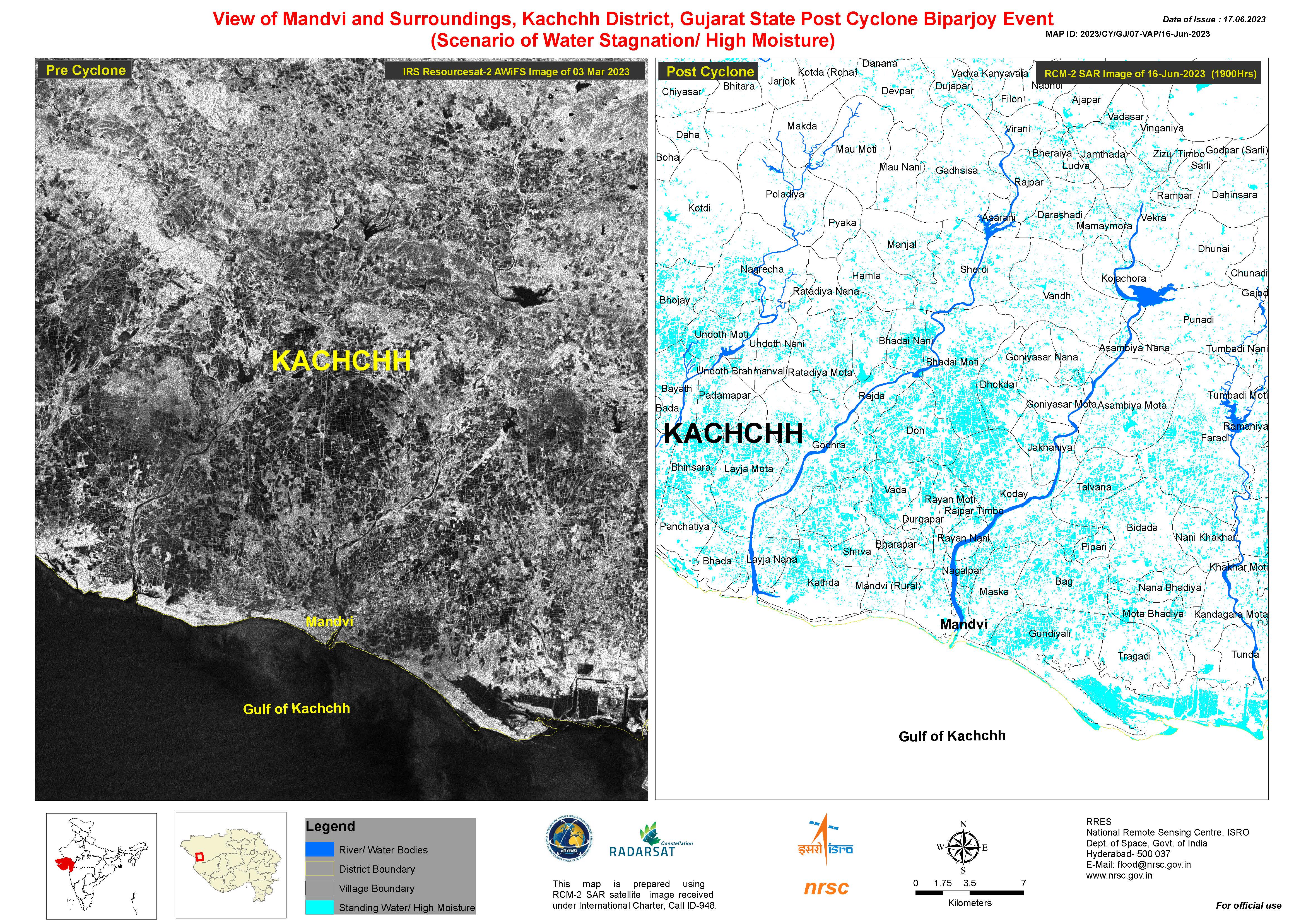
View of Mandvi and Surroundings, Kachchh District, Gujarat State Post Cyclone Biparjoy
Direitos autorais: ResourceSat-2 (IRS-R2) © ISRO
RADARSAT Constellation Mission Imagery © Government of Canada (2023) - RADARSAT is an official mark of the Canadian Space Agency
Map produced by the National Remote Sensing Centre, ISRO.
Information about the Product
Adquirida: ResourceSat-2: 03/03/2023
RCM: 16/06/2023
Fonte: ResourceSat-2 and RCM
Categoria: Reference Map
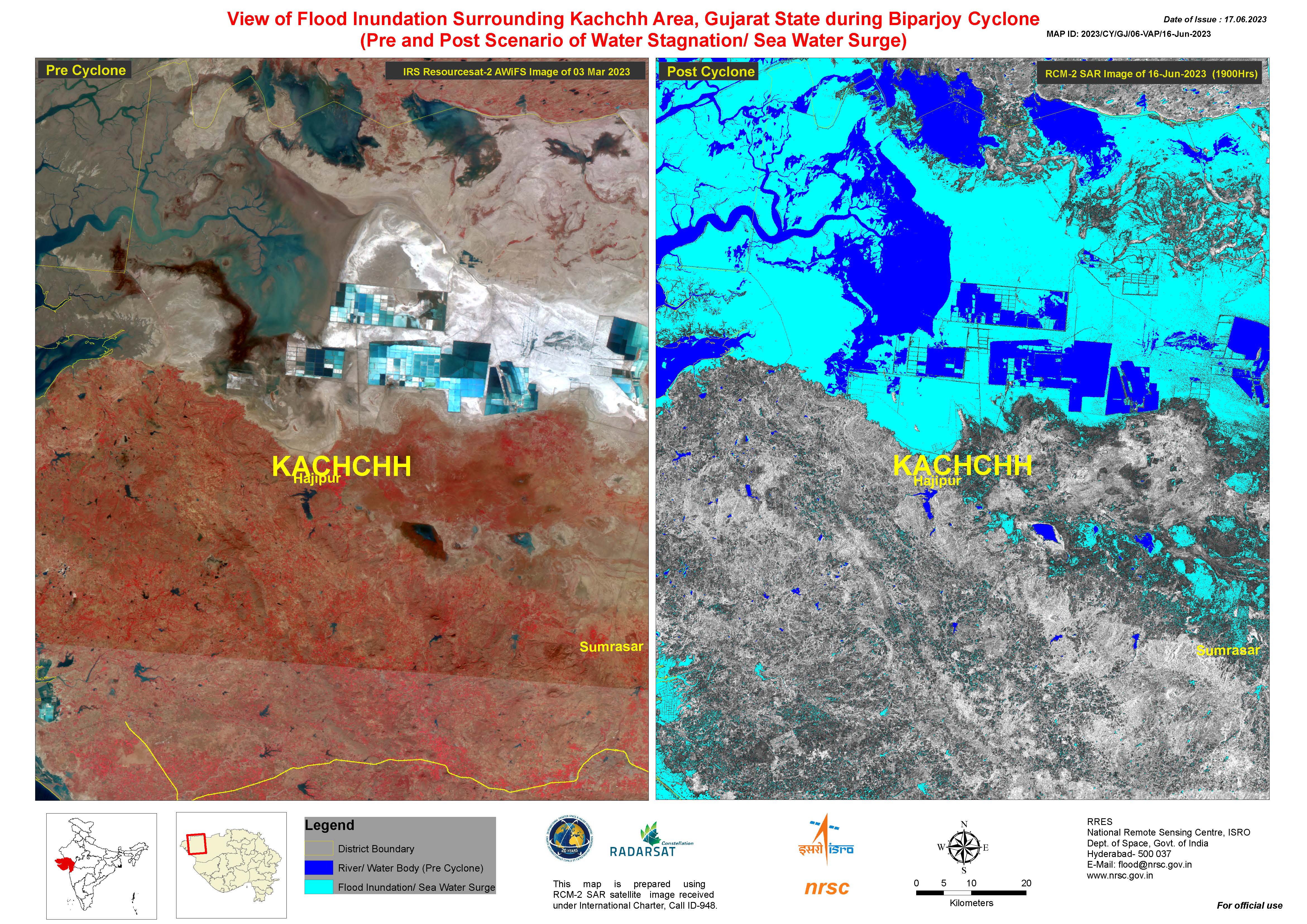
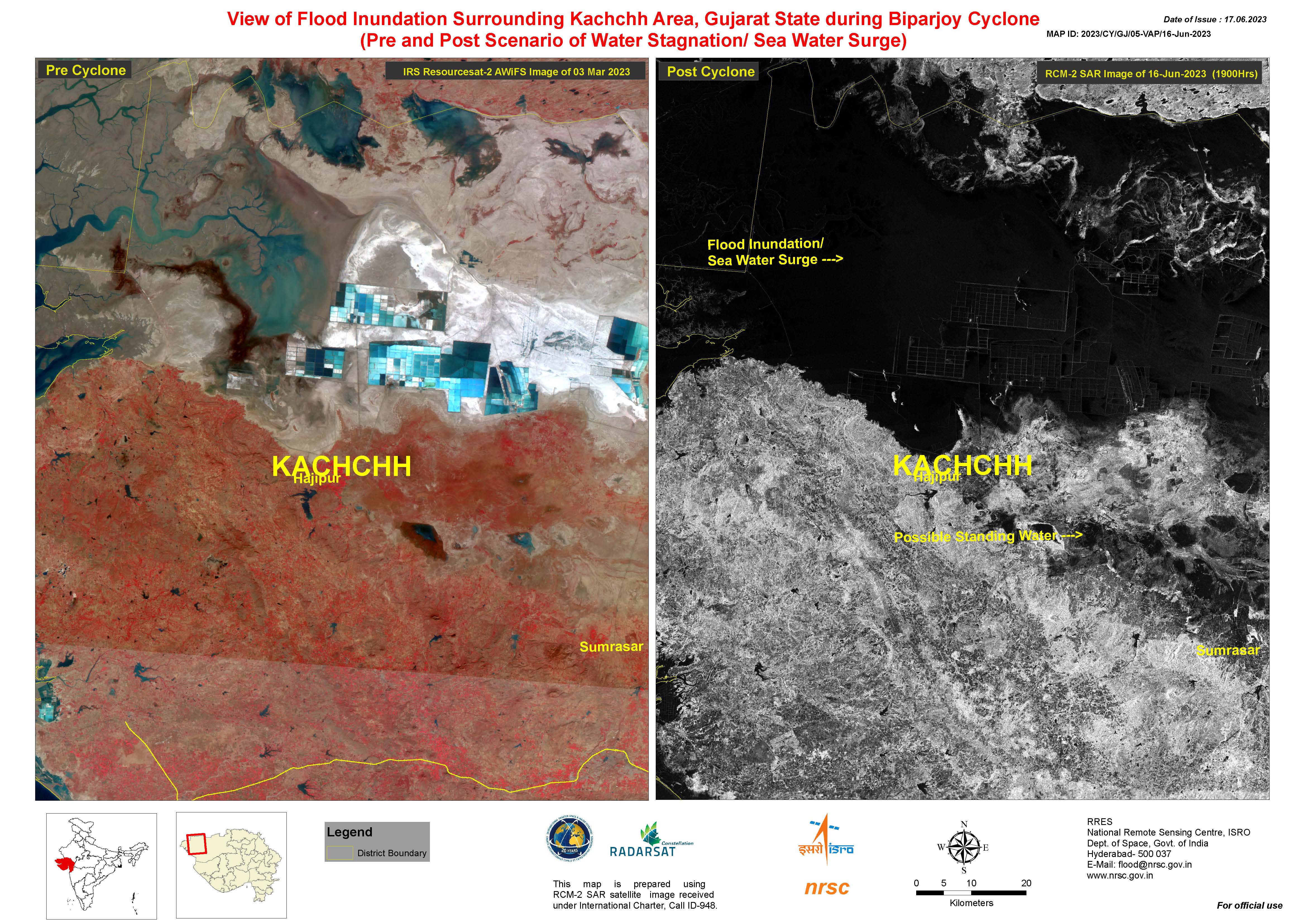
View of Flood Inundation Surrounding Kachchh Area, Gujarat State during Cyclone Biparjoy
Direitos autorais: ResourceSat-2 (IRS-R2) © ISRO
RADARSAT Constellation Mission Imagery © Government of Canada (2023) - RADARSAT is an official mark of the Canadian Space Agency
Map produced by the National Remote Sensing Centre, ISRO.
Information about the Product
Adquirida: ResourceSat-2: 03/03/2023
RCM: 16/06/2023
Fonte: ResourceSat-2 and RCM
Categoria: Reference Map
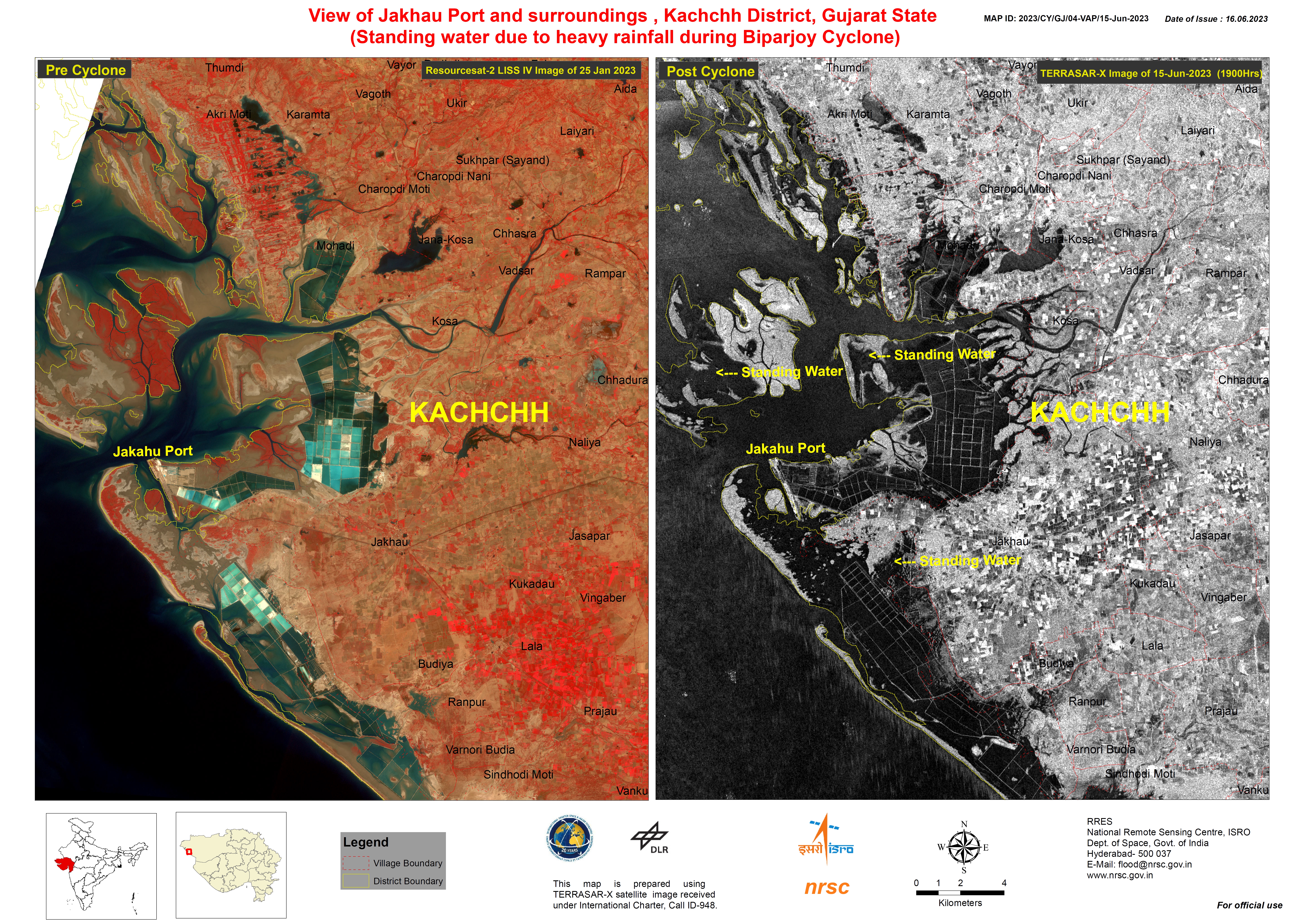
Areas affected by Heavy Rainfall around the Jakhau Port, Kachchh District, Gujarat State
Direitos autorais: ResourceSat-2 (IRS-R2) © ISRO
TerraSAR-X © DLR e.V. (2023), Distribution Airbus DS Geo GmbH
Map produced by the National Remote Sensing Centre, ISRO.
Information about the Product
Adquirida: ResourceSat-2: 25/01/2023
TerraSAR-X: 15/06/2023
Fonte: ResourceSat-2 and TerraSAR-X
Categoria: Reference Map
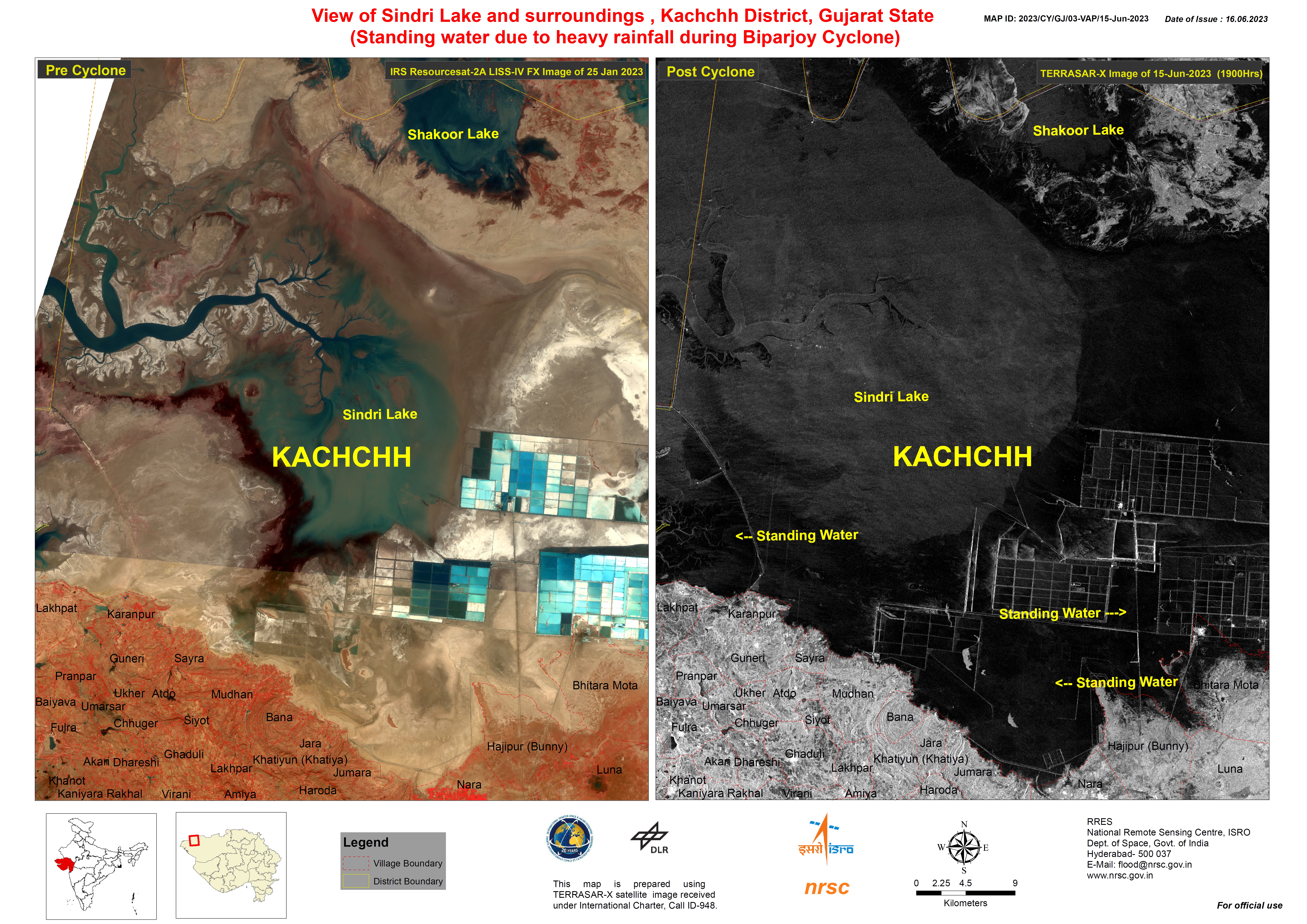
Areas affected by Heavy Rainfall around the Sindri Lake, Kachchh District, Gujarat State
Direitos autorais: ResourceSat-2 (IRS-R2) © ISRO
TerraSAR-X © DLR e.V. (2023), Distribution Airbus DS Geo GmbH
Map produced by the National Remote Sensing Centre, ISRO.
Information about the Product
Adquirida: ResourceSat-2: 25/01/2023
TerraSAR-X: 15/06/2023
Fonte: ResourceSat-2 and TerraSAR-X
Categoria: Reference Map
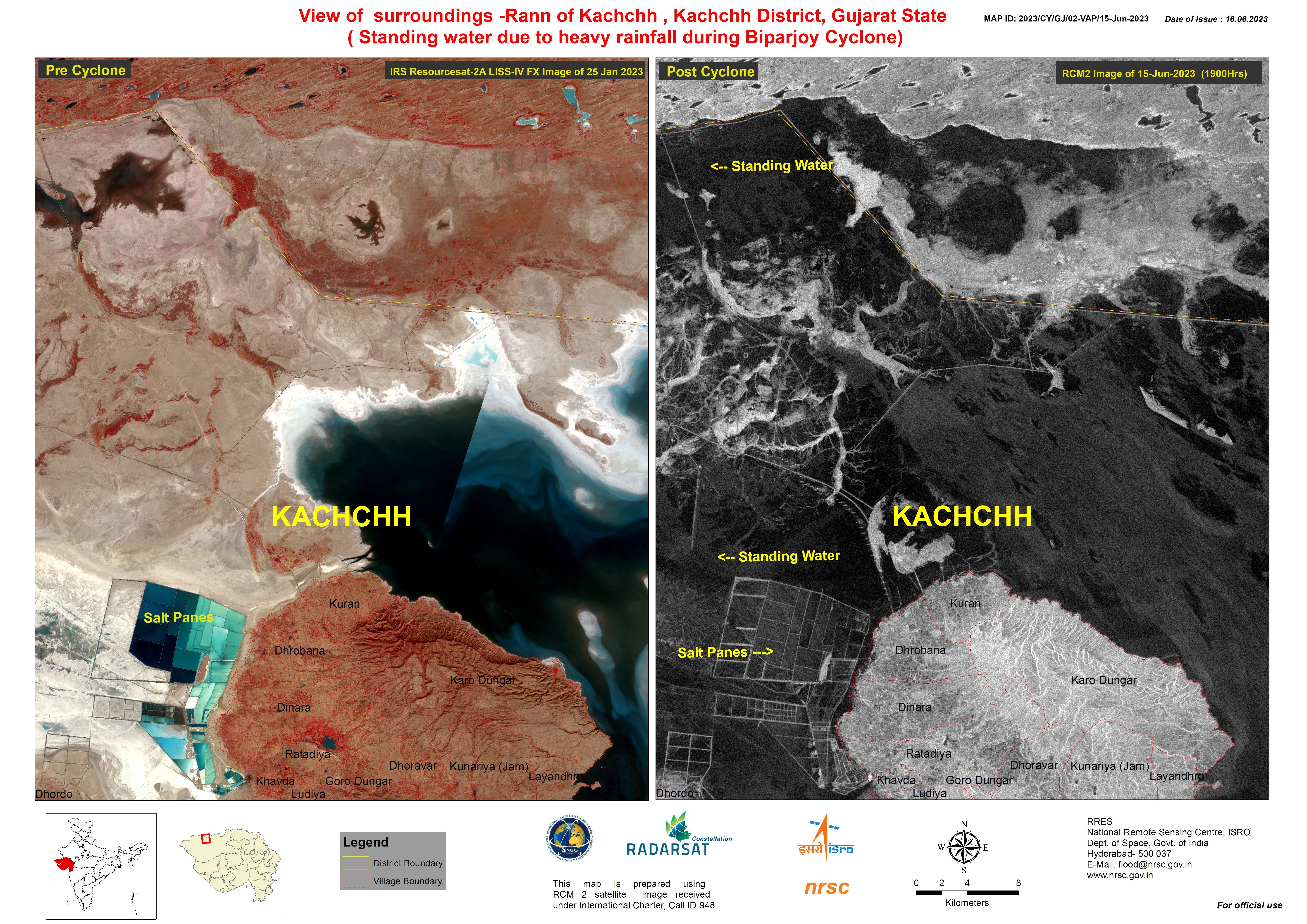
Areas affected by Heavy Rainfall in Rann of Kachchh, Kachchh District, Gujarat State
Direitos autorais: ResourceSat-2 (IRS-R2) © ISRO
RADARSAT Constellation Mission Imagery © Government of Canada (2023) - RADARSAT is an official mark of the Canadian Space Agency
Map produced by the National Remote Sensing Centre, ISRO.
Information about the Product
Adquirida: ResourceSat-2: 25/01/2023
RCM: 15/06/2023
Fonte: ResourceSat-2 and RCM
Categoria: Reference Map
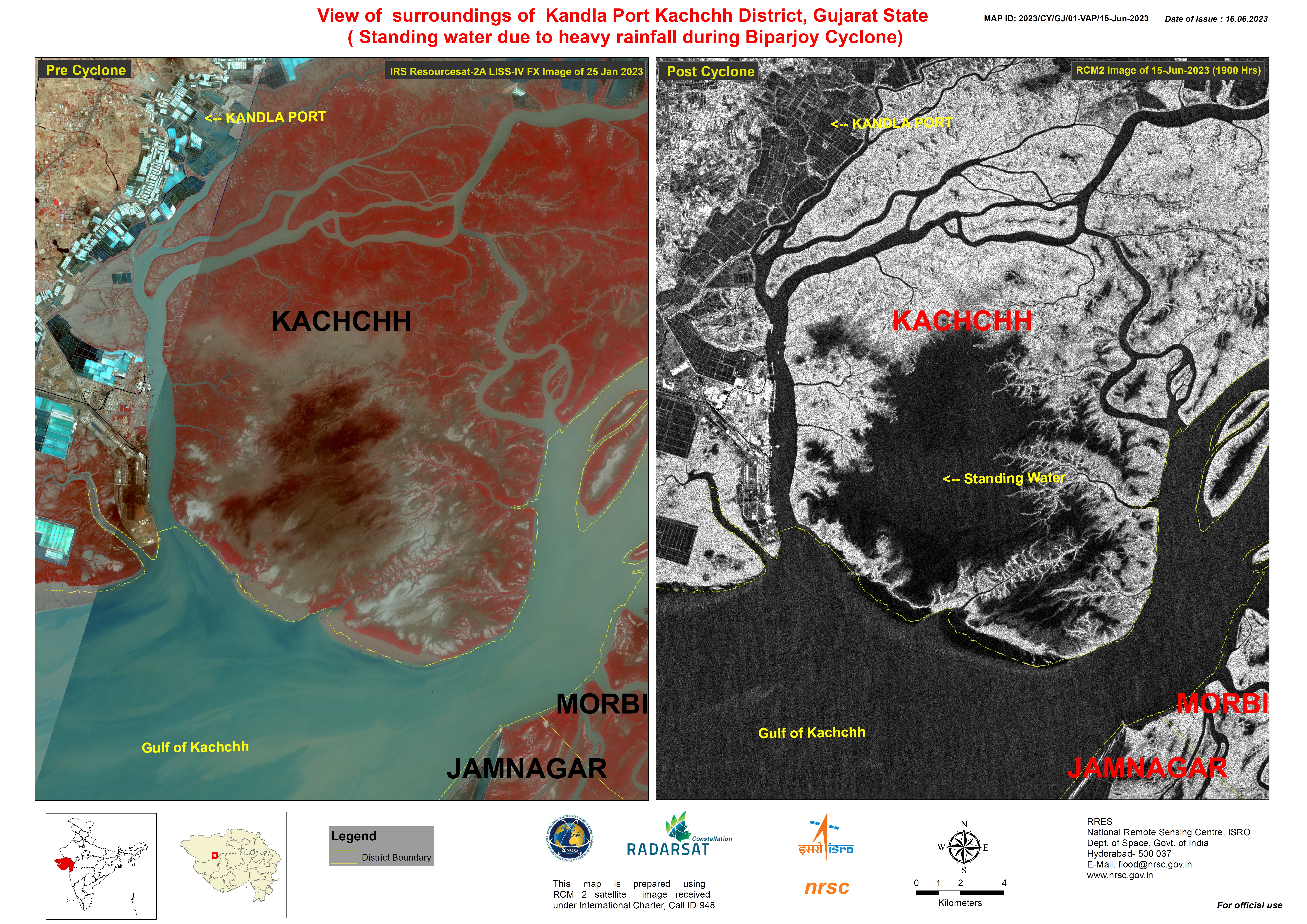
Areas affected by Heavy Rainfall in Kandla Port, Kachchh District, Gujarat State
Direitos autorais: ResourceSat-2 (IRS-R2) © ISRO
RADARSAT Constellation Mission Imagery © Government of Canada (2023) - RADARSAT is an official mark of the Canadian Space Agency
Map produced by the National Remote Sensing Centre, ISRO.
Information about the Product
Adquirida: ResourceSat-2: 25/01/2023
RCM: 15/06/2023
Fonte: ResourceSat-2 and RCM
Categoria: Reference Map
 Voltar ao arquivo completo da Ativação

