 English
 Spanish
 French
 Chinese
 Russian
 Portuguese
 Latest Activation
Charter activations
Landslide in Colombia
The River Liboriana in Colombia burst its banks on 19 May 2015, causing a landslide that has left 78 people dead, and hundreds injured.
It is reportedly the worst natural disaster Colombia has suffered since 1999.
The landslide occurred at 03:00 local time in the Antioquia Province, while most people were asleep, taking residents by surprise. It was caused by heavy rain which affected the Liboriana. When the river flooded, mud and debris was swept through the region, driving through houses alongside the river and leaving hundreds homeless.
The town of Salgar was badly affected by the landslide, and the neighbourhood of Las Margaritas was almost demolished. Houses and other buildings were swept away by the force of the mud and debris.
Search and rescue efforts are continuing along a 40 km stretch of the Liboriana River, to find survivors who were buried under the mud, but it is unknown how many people are still missing in the disaster.
Antioquia is a mountainous region of Colombia, and often experiences landslides during periods of heavy rain.
| Tipo de evento: | Landslide |
| Local do evento: | Colombia |
| Data da Ativação da Carta: | 20 May 2015 |
| Tempo de Ativação da Carta: | 10:30:43 |
| Zona de Tempo da Ativação da Carta: | UTC-06:00 |
| Requisitante da Carta: | USGS on behalf of UNGRG |
| Gerenciamento de projeto: | CENAD (Brazilian National Risk and Disaster Management Center) |
Products
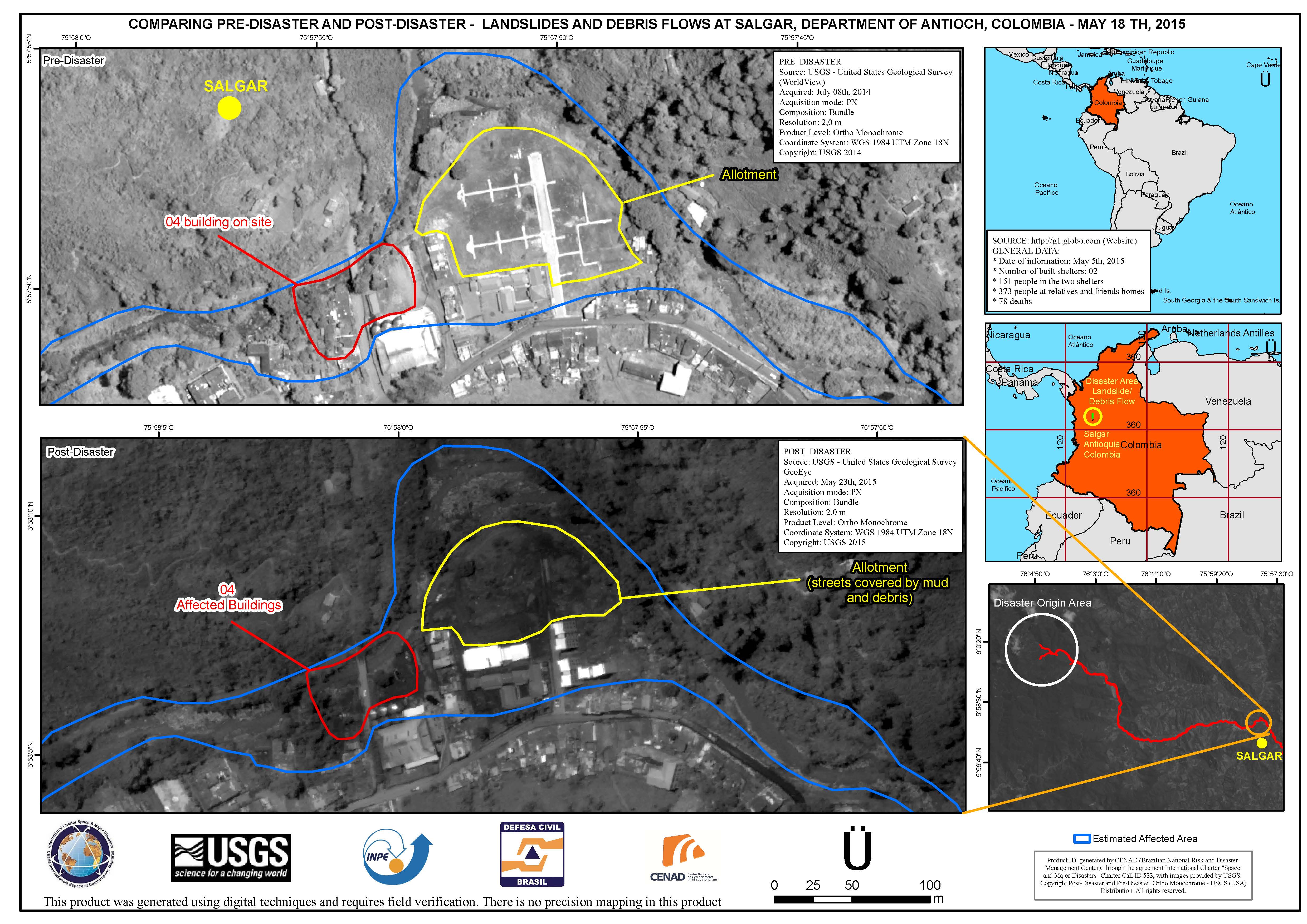
Comparison of landslides and debris flow at Salgar, in the Department of Antioch, Colombia
Direitos autorais: DigitalGlobe Inc.
Map produced by CENAD (Brazilian National Risk and Disaster Management Center)
Information about the Product
Adquirida: WorldView: 08/07/2014
GeoEye: 23/05/2015
Fonte: WorldView / GeoEye
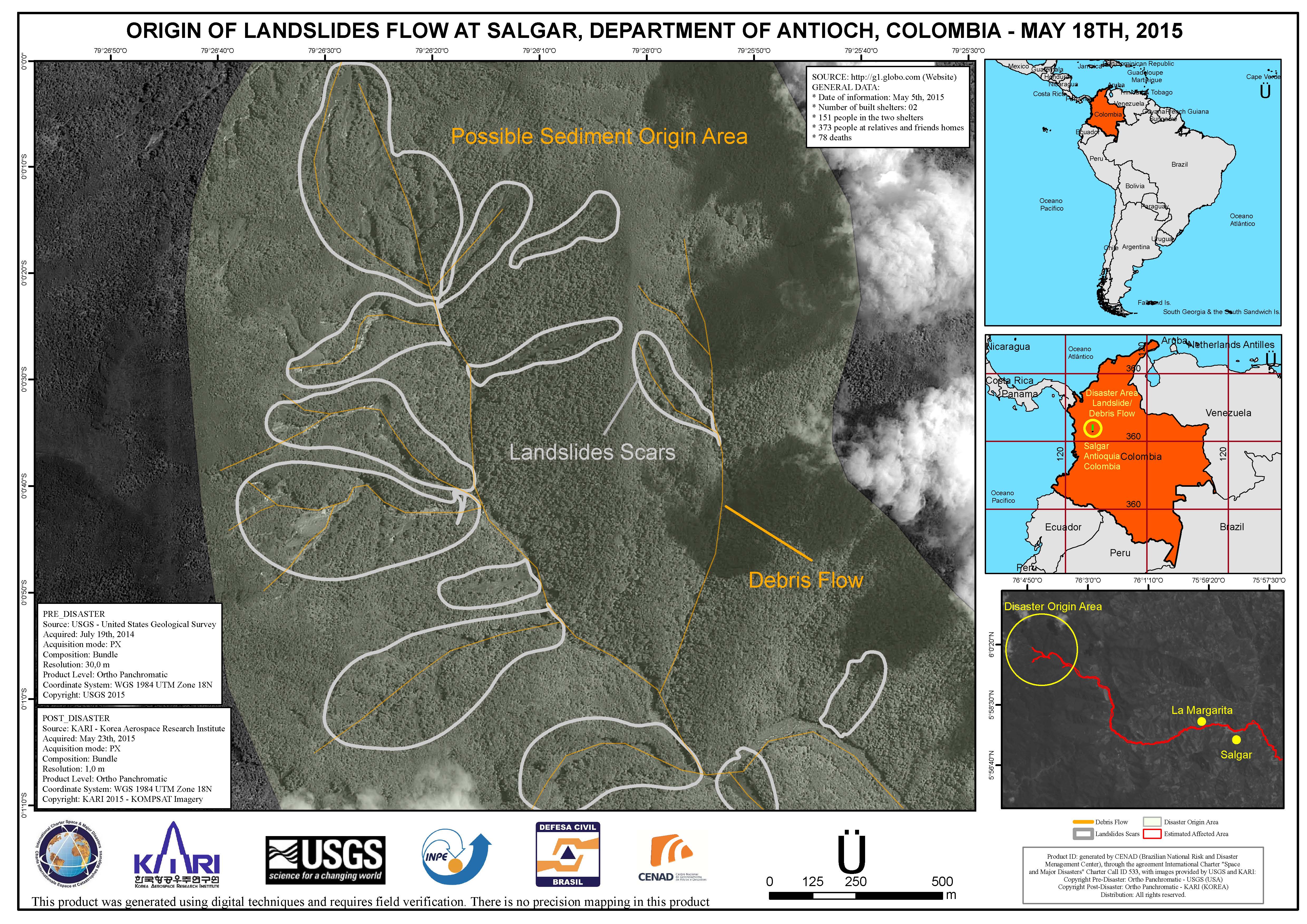
Origin point of the landslide at Salgar in the Department of Antioch, Colombia - Landslide scars and debris flows are indicated
Direitos autorais: USGS
KOMPSAT © Korea Aerospace Research Institute (KARI)
Map produced by CENAD (Brazilian National Risk and Disaster Management Center)
Information about the Product
Adquirida: Pre-disaster: 19/07/2014
Post-disaster: 23/05/2015
Fonte: USGS / KOMPSAT
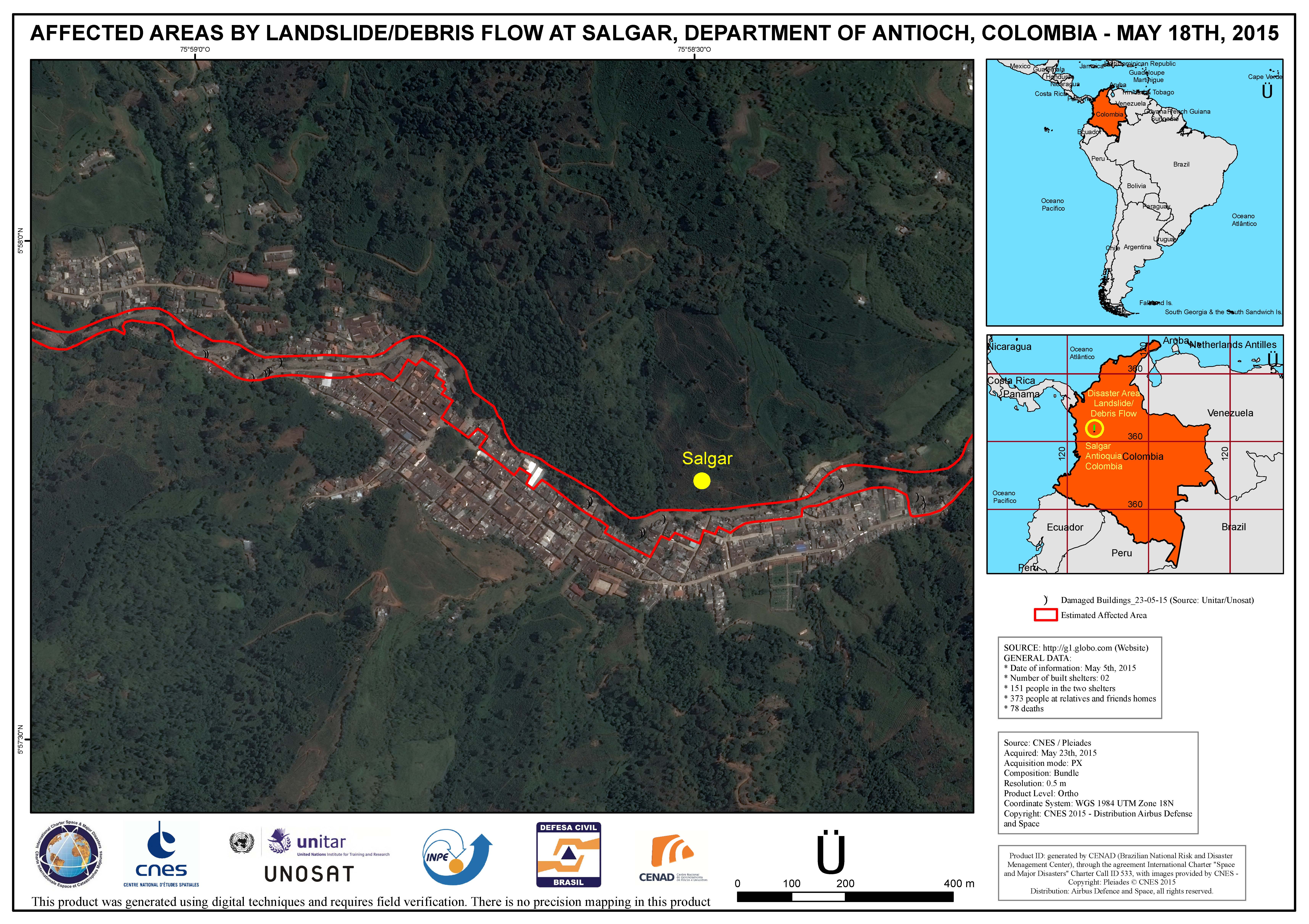
Estimated area affected by landslide/debris flow at Salgar, in the Department of Antioch, Colombia
Direitos autorais: CNES 2015 - Distribution: Airbus Defense and Space, all rights reserved
Map produced by CENAD (Brazilian National Risk and Disaster Management Center)
Information about the Product
Adquirida: 23/05/2015
Fonte: Pleiades
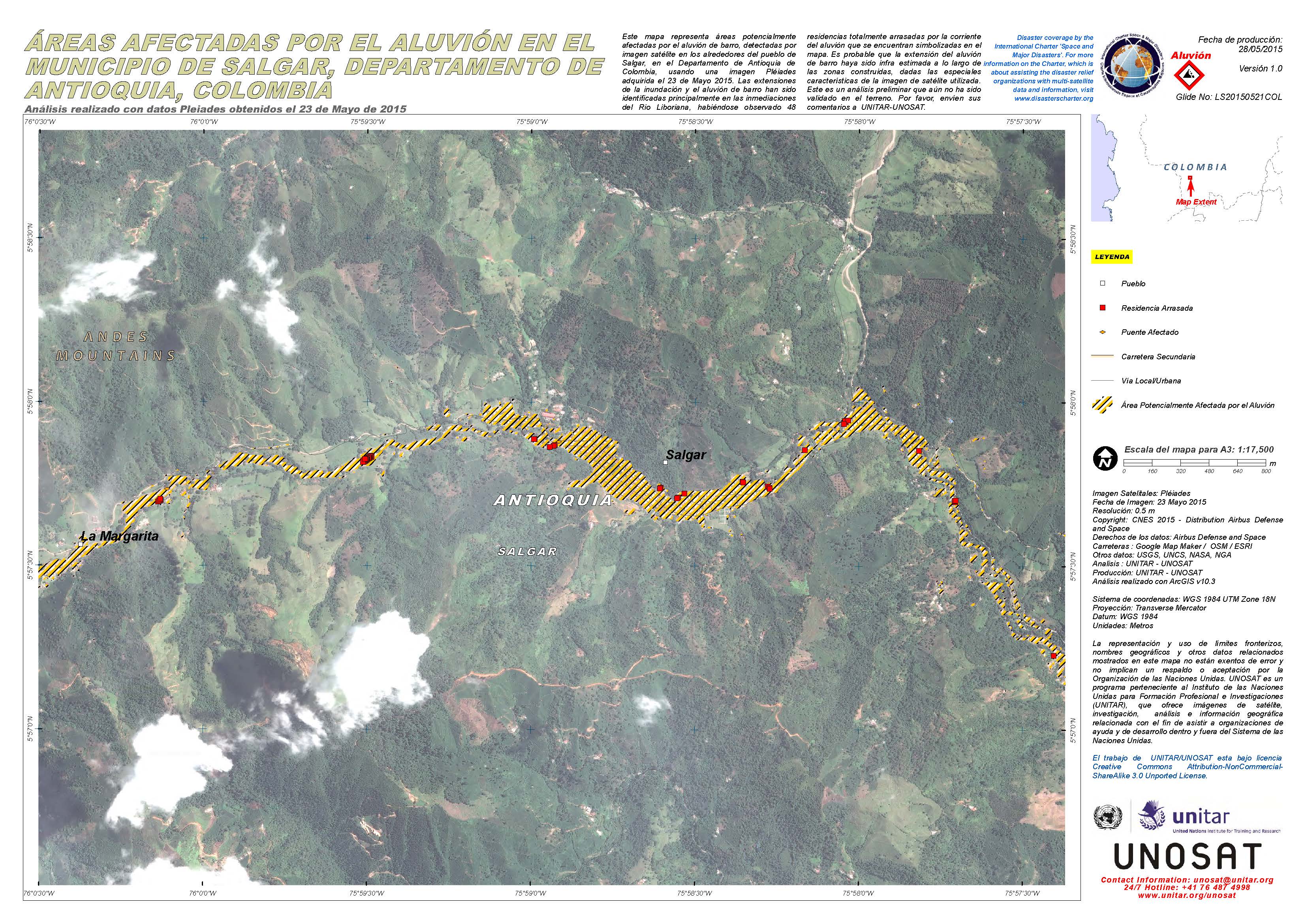
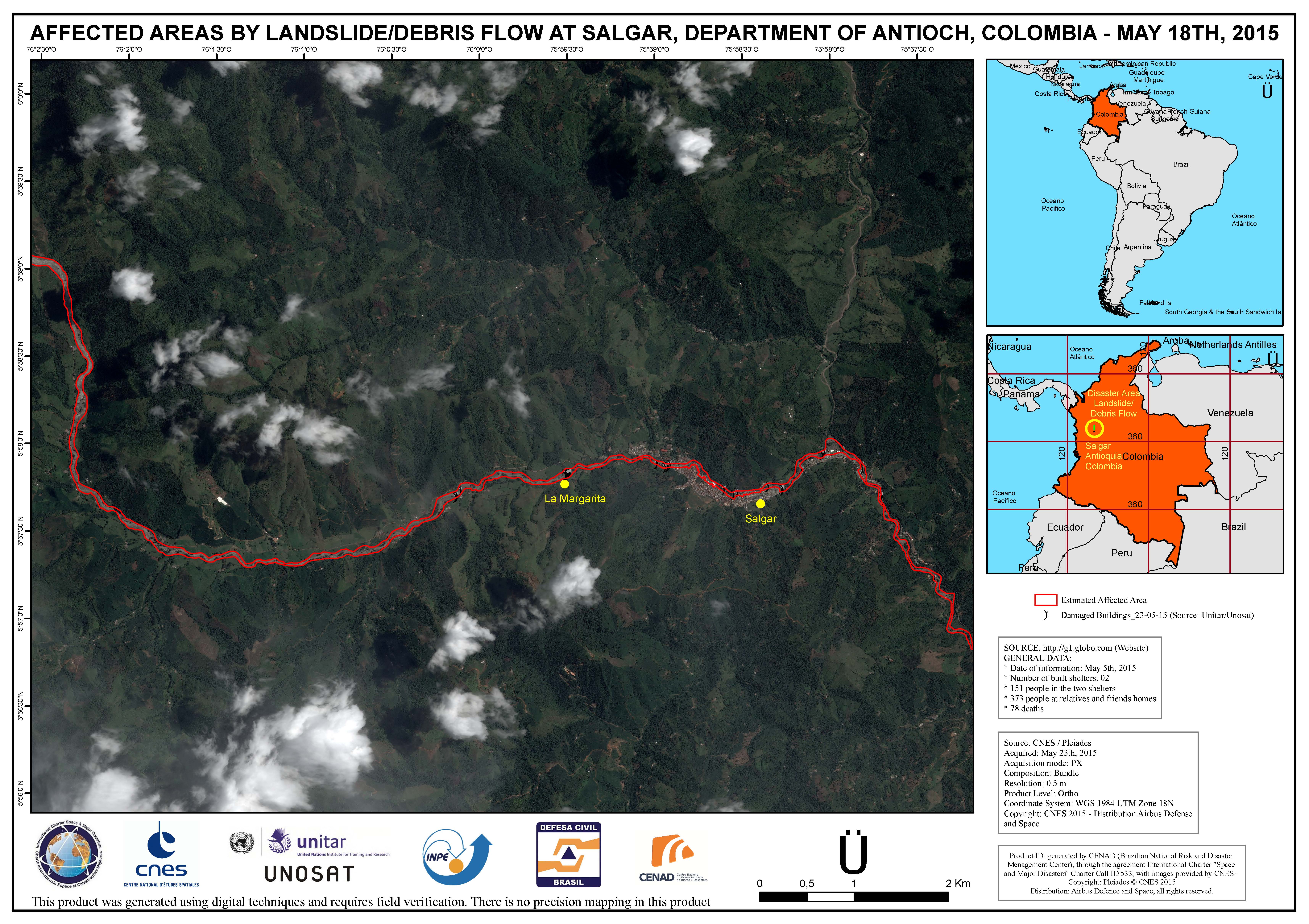
Areas affected by landslide/debris flow at Salgar, in the Department of Antioch, Colombia
Direitos autorais: CNES 2015 - Distribution: Airbus Defense and Space, all rights reserved
Map produced by CENAD (Brazilian National Risk and Disaster Management Center)
Information about the Product
Adquirida: 23/05/2015
Fonte: Pleiades
 Voltar ao arquivo completo da Ativação

