Charter activations
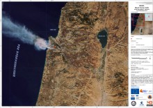
Forest Fire in Israel
About 40 people have died in what is thought to be Israel's largest ever forest fire, police have said. Many of the victims were prison guards travelling on a bus which was caught in the inferno in the Carmel Mountains near the northern city of Haifa.
Thousands of people, including prison inmates, have been evacuated from the area. Scores more have been injured, the ambulance service said. The cause of the blaze was not immediately known.
Israel's Prime Minister Benjamin Netanyahu, who has visited the affected area, said it was an "unprecedented disaster".
For this activation, value adding support has been provided by the European project GMES SAFER.
| Tipo de evento: | Fire |
| Local do evento: | Israel |
| Data da Ativação da Carta: | 02/12/2010 |
| Requisitante da Carta: | COGIC |
| Gerenciamento de projeto: | CNES |
Products

Disaster assessment map at 1:12 500, detail of the potential impact within urbanised areas, within the maximum potential fire affected area.
Direitos autorais: SERTIT 2010 - Map produced by SERTIT in the frame of the GMES/Safer project
Information about the Product
Adquirida: 08/12/2010
Fonte: SPOT 5

Disaster monitoring map at 1:12 500, detail of the fire dynamics viewed the 03 December 2010 (Landsat 5), the 04 December 2010 (RapidEye) and the 08 December 2010 just after the fire had been put out.
Direitos autorais: SERTIT 2010 - Map produced by SERTIT in the frame of the GMES/Safer project
Information about the Product
Adquirida: 08/12/2010
Fonte: Landsat 5, RaipdEye, SPOT5

Crisis map at a scale of 1: 12 500, view of Mont Carmel derived derived from a RapidEye acquired the 4 December 2010. This false colour composite image, allows a better distinguishing between badly affected areas, and safer ones. Safe vegetation appears in redish colour whereas burnt areas are in blue grey colour.
Direitos autorais: SERTIT 2010, ESRI - Map produced by SERTIT in the frame of the GMES/Safer project
Information about the Product
Adquirida: 04/12/2010
Fonte: RapidEye (provided in the frame of the GMES/Safer project)

Crisis map at a scale of 1: 25 000, view of Mount Carmel, an area very affected by fire, and the southern neighbourhoods of Haifa town derived from a RapidEye acquired the 4 December 2010
Direitos autorais: SERTIT 2010, ESRI - Map produced by SERTIT in the frame of the GMES/Safer project
Information about the Product
Adquirida: 04/12/2010
Fonte: RapidEye (provided in the frame of the GMES/Safer project)

Reference map at a scale of 1: 25 000, view of Mont Carmel and the southern neighbourhoods of Haifa town , derived from a SPOT5 acquired the 25 December 2009
Direitos autorais: SERTIT 2010, ESRI - Map produced by SERTIT in the frame of the GMES/Safer project
Information about the Product
Adquirida: 04/12/2010
Fonte: SPOT 5

Disaster location map at 1 : 200 000, overview derived from medium resolution MERIS data acquired the 3rd of December 2010 at 08 :35 (UTC)
Direitos autorais: SERTIT 2010, ESRI - Map produced by SERTIT in the frame of the GMES/Safer project
Information about the Product
Adquirida: 03/12/2010
Fonte: MERIS
 Voltar ao arquivo completo da Ativação

 English
 Spanish
 French
 Chinese
 Russian
 Portuguese


