 English
 Spanish
 French
 Chinese
 Russian
 Portuguese
 Latest Activation
Charter activations
Flash Floods in India
Northern India was hit by flash floods and landslides caused by heavy rainfall on Sunday 9th July 2023. According to authorities and local reports, this was the country's wettest July day in more than 40 years (1982) with 153 millimeters (6 inches) of rain recorded by the Indian Meterological Department.
Red alerts were issued, indicating the highest threat level, for the Northern states of Himachal Pradesh, Uttarakhand, Punjab and Haryana. Landslide warnings were also issued for Uttarakhand and Himachal Pradesh.
41 people have passed away since flooding began in Himachal Pradesh and Punjab and 2000 people have been temporarily evacuated as further rain is expected until the 16th July but will, eventually, ease. District teams, the Indian army and the National Disaster Response Force are currently coordinating relief efforts and are working to reopen roads affected by landslides.
For the first time since 1978, Delhi's Yamuna River surpassed the highest flood level mark with levels reaching 207.55 meters according to the Central Water Commission.
| Tipo de evento: | Floods |
| Local do evento: | India |
| Data da Ativação da Carta: | 2023-07-13 |
| Tempo de Ativação da Carta: | 12:00 |
| Zona de Tempo da Ativação da Carta: | UTC+05:30 |
| Requisitante da Carta: | ISRO |
| ID da Ativação: | 827 |
| Gerenciamento de projeto: | AV SureshBabu (NRSC) |
Products
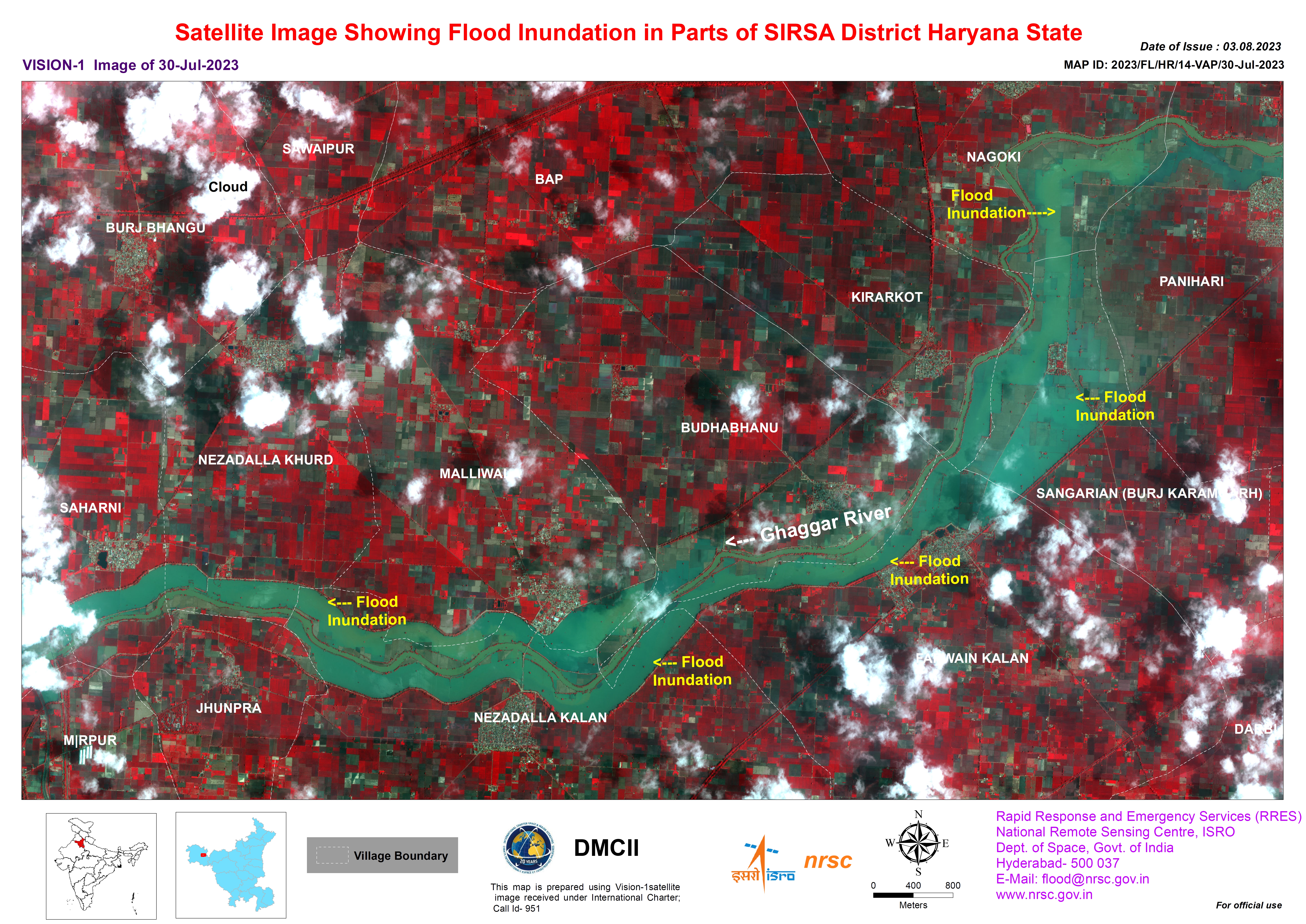
Areas of Flood Inundation in parts of the Haryana State
Direitos autorais: RADARSAT Constellation Mission Imagery © Government of Canada (2023) - RADARSAT is an official mark of the Canadian Space Agency
Map produced by the National Remote Sensing Centre, ISRO.
Information about the Product
Adquirida: 15/07/2023
Fonte: RCM
Categoria: Reference Map
Areas of Flood Inundation in parts of the Punjab State, India
Direitos autorais: RADARSAT Constellation Mission Imagery © Government of Canada (2023) - RADARSAT is an official mark of the Canadian Space Agency
Map produced by the National Remote Sensing Centre, ISRO.
Information about the Product
Adquirida: 15/07/2023
Fonte: RCM
Categoria: Reference Map
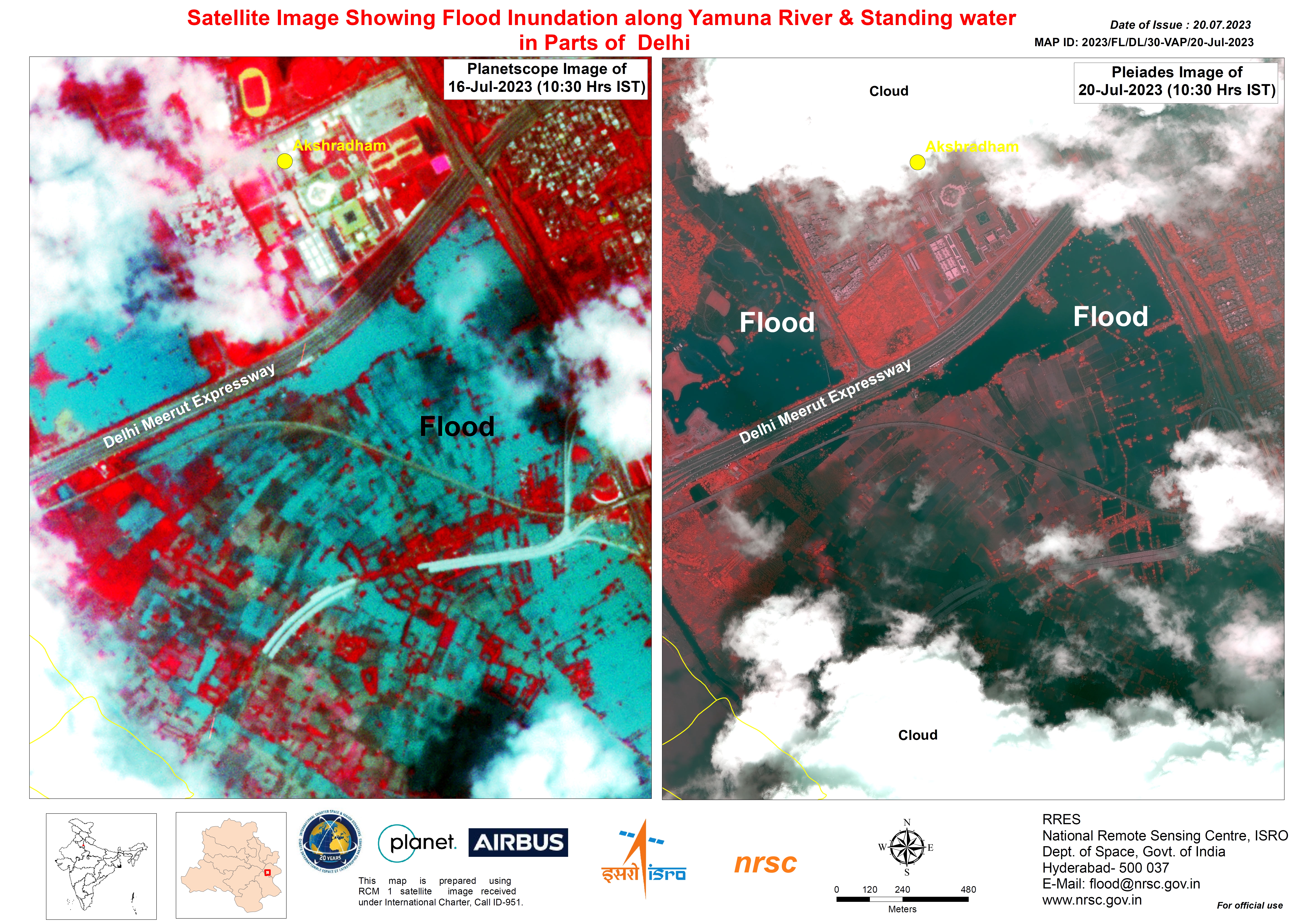
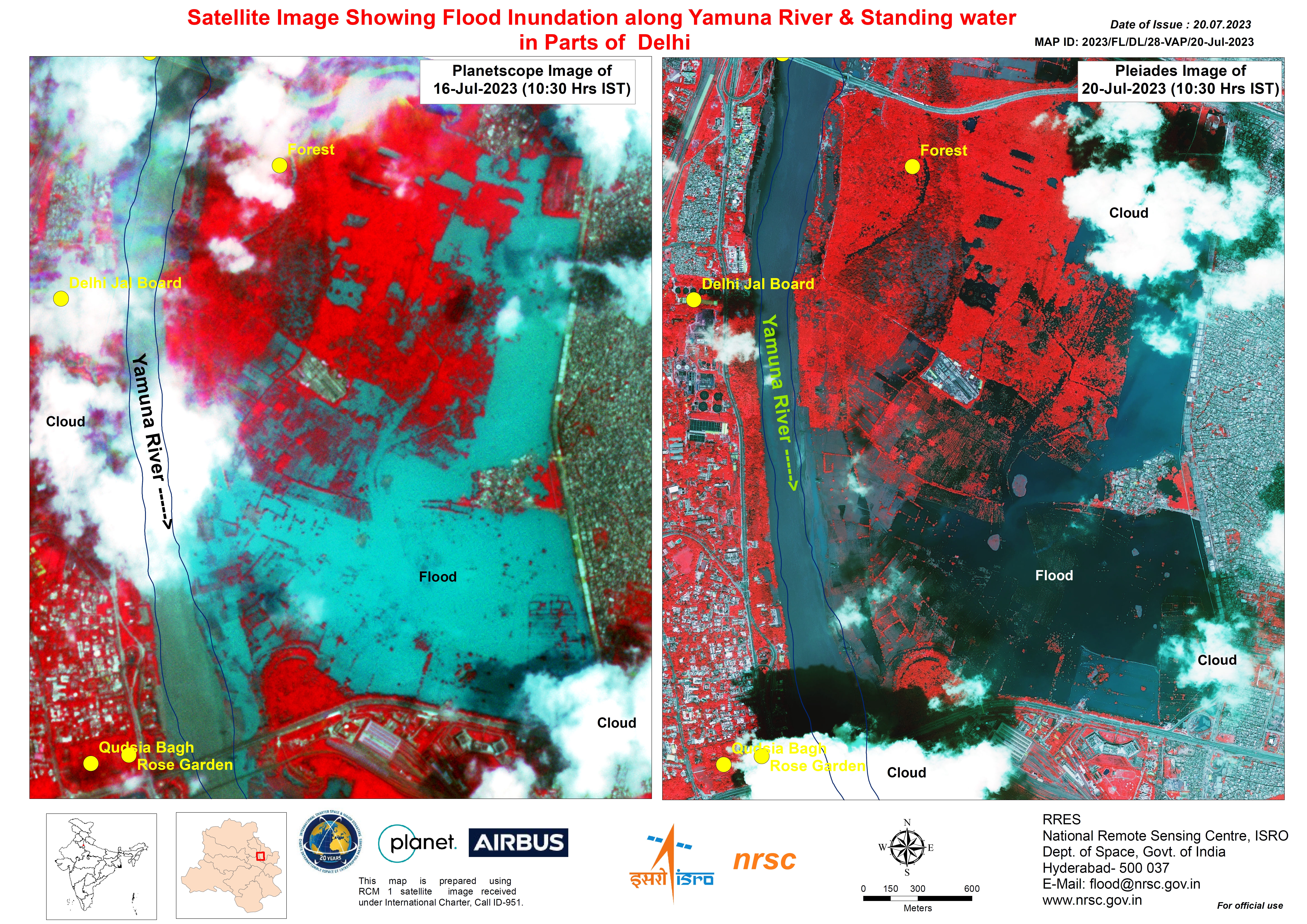
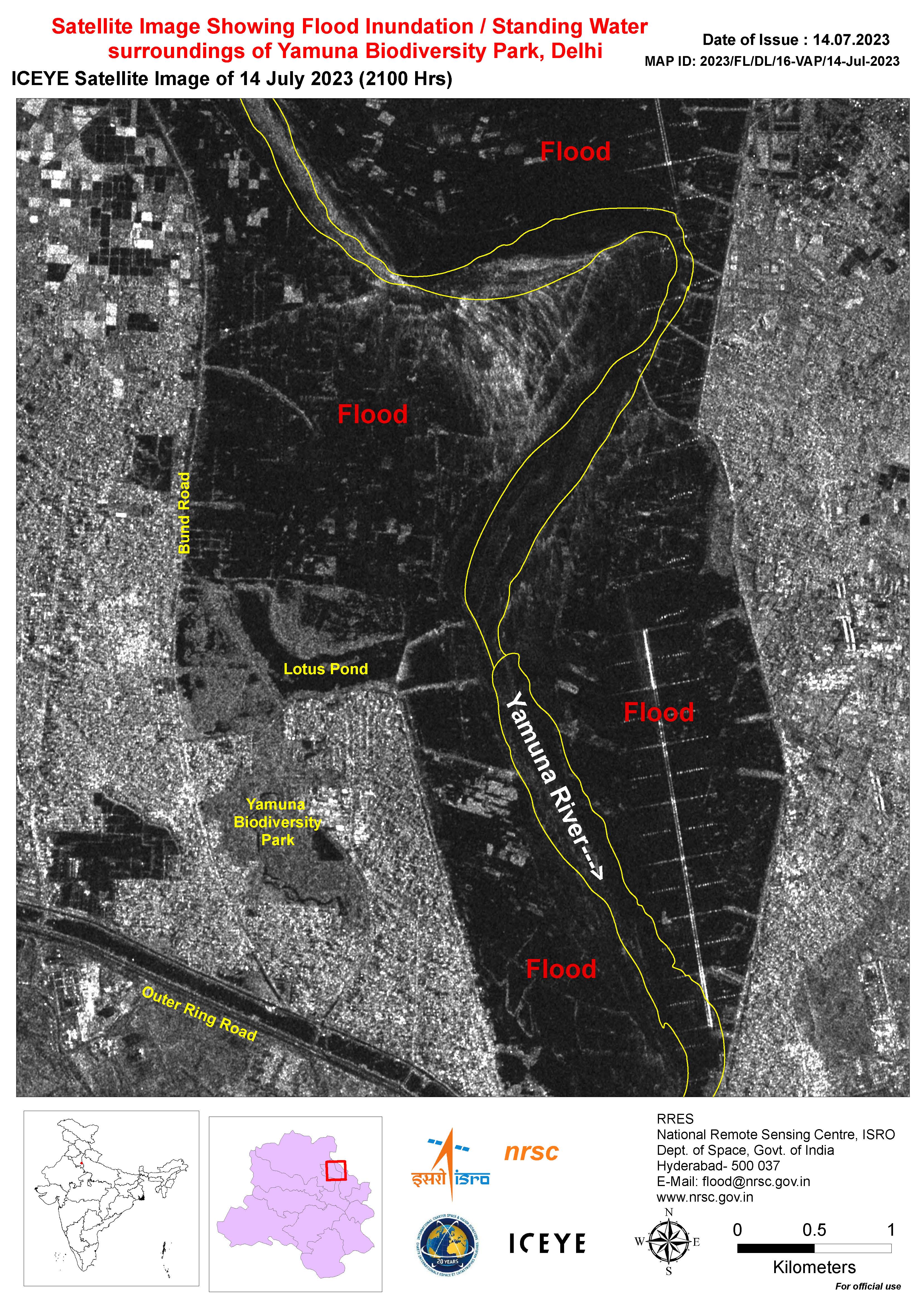
Flood Inundation along the Yamuna River and Standing Water in Parts of Delhi
Direitos autorais: © Planet Labs Inc. (2023)
Includes Pleiades material © CNES (2023), Distribution Airbus DS.
Map produced by the National Remote Sensing Centre, ISRO.
Information about the Product
Adquirida: PlanetScope: 16/07/2023
Pleiades: 20/07/2023
Fonte: PlanetScope and Pleiades
Categoria: Reference Map
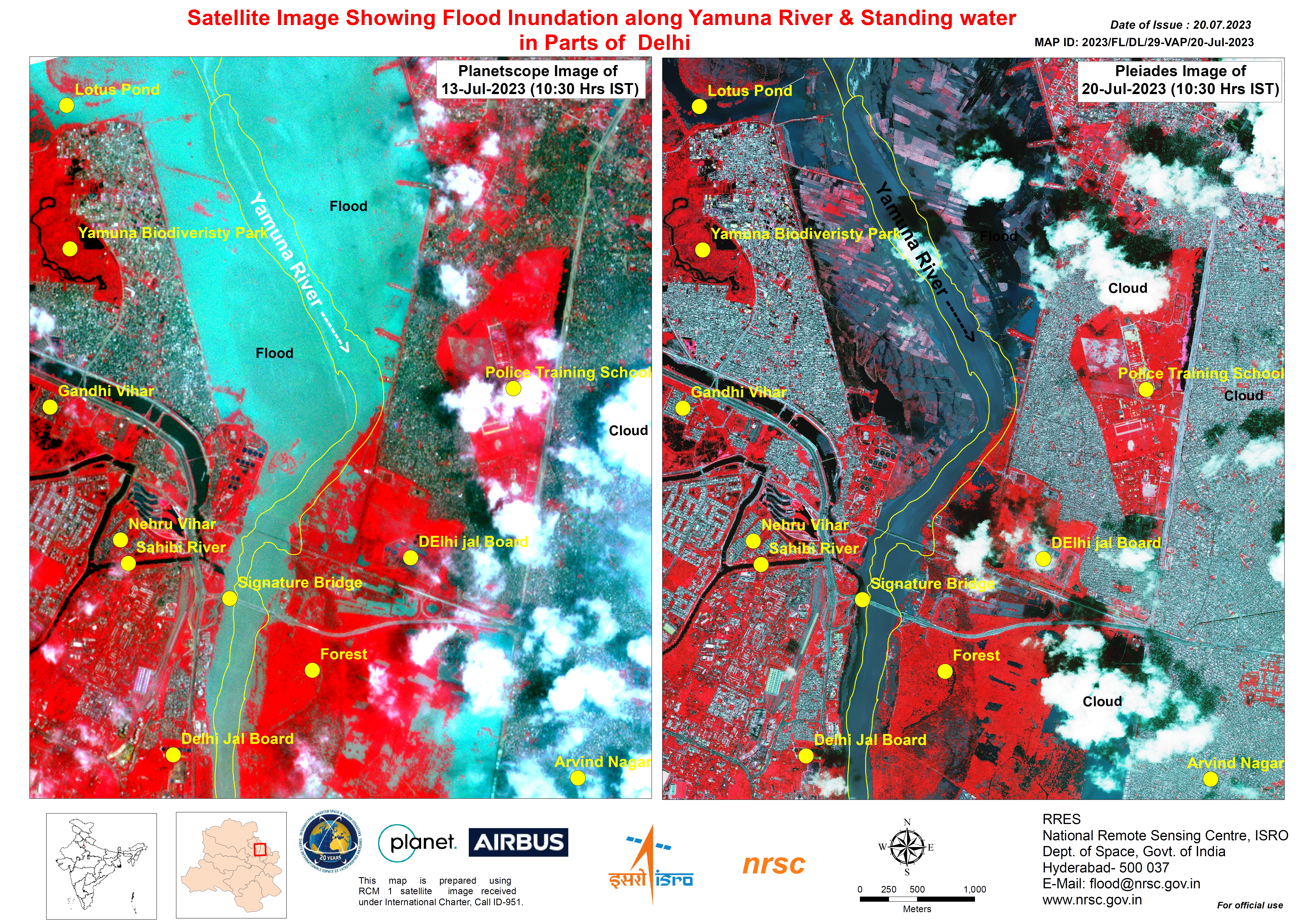
Flood Inundation along the Yamuna River and Standing Water in Parts of Delhi
Direitos autorais: © Planet Labs Inc. (2023)
Includes Pleiades material © CNES (2023), Distribution Airbus DS.
Map produced by the National Remote Sensing Centre, ISRO.
Information about the Product
Adquirida: PlanetScope: 13/07/2023
Pleiades: 20/07/2023
Fonte: PlanetScope and Pleiades
Categoria: Reference Map
Flood Inundation along the Yamuna River and Standing Water in Parts of Delhi
Direitos autorais: © Planet Labs Inc. (2023)
Includes Pleiades material © CNES (2023), Distribution Airbus DS.
Map produced by the National Remote Sensing Centre, ISRO.
Information about the Product
Adquirida: PlanetScope: 16/07/2023
Pleiades: 20/07/2023
Fonte: PlanetScope and Pleiades
Categoria: Reference Map
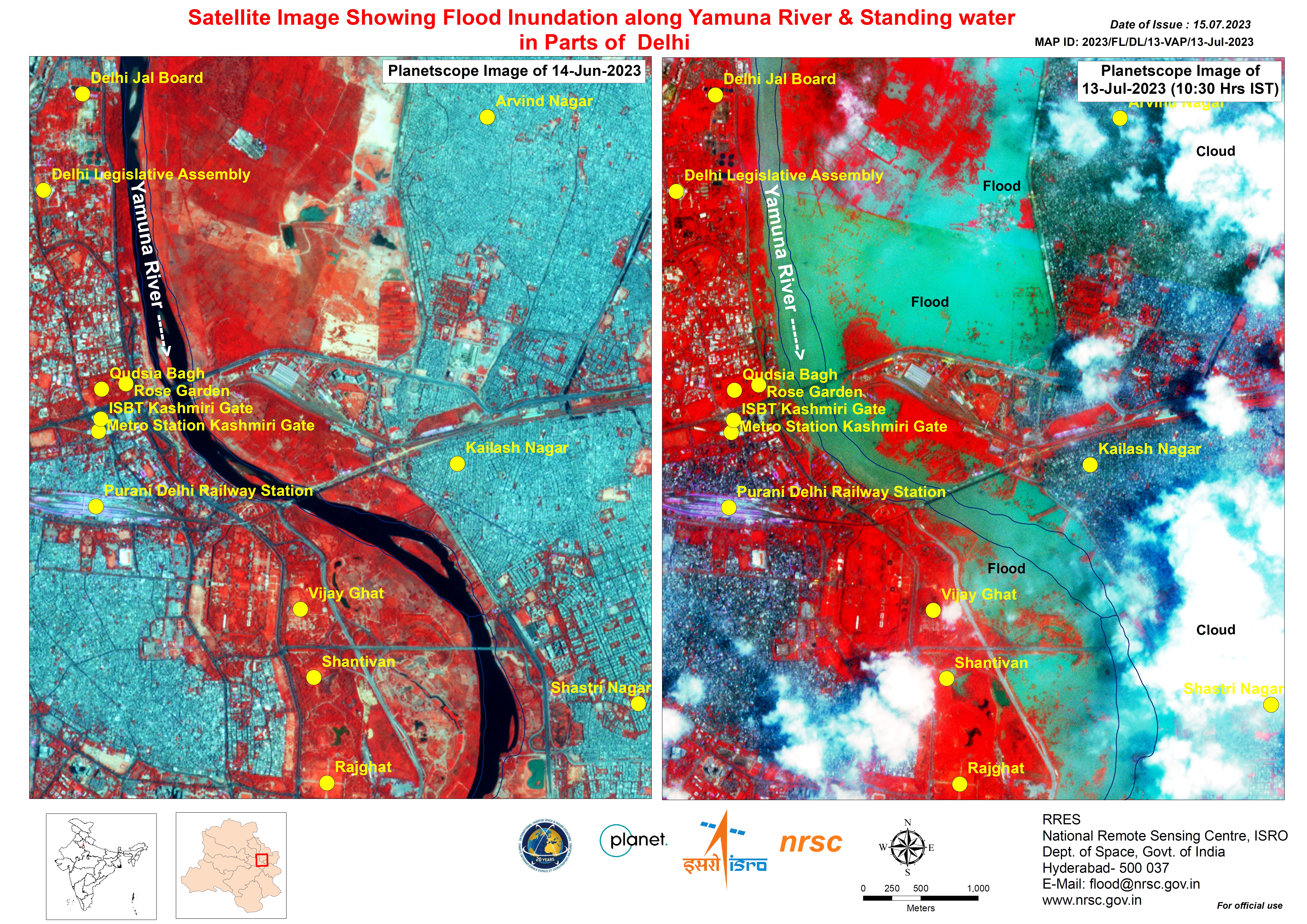
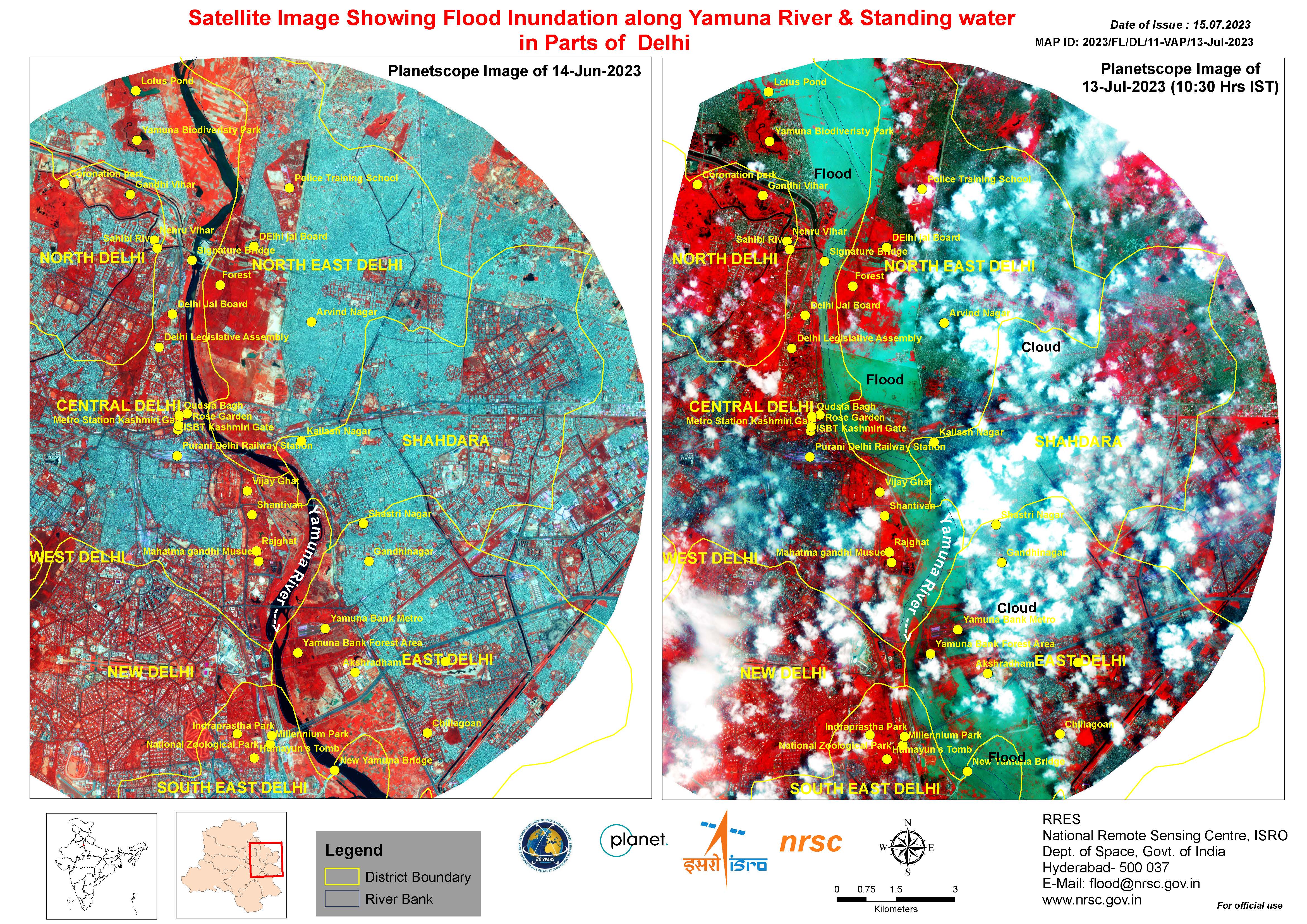
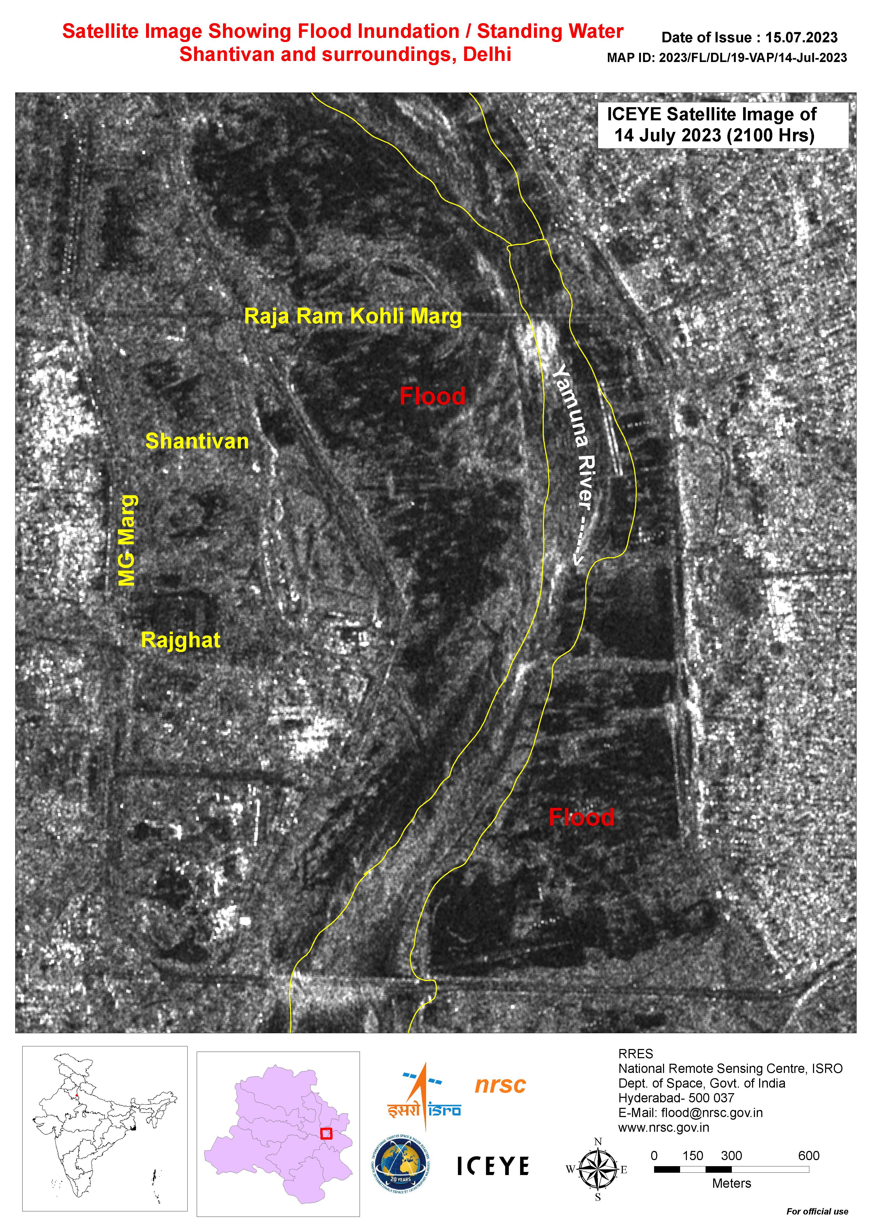
Satellite Image Showing Flood Inundation along the Yamuna River and Standing water in Parts of Delhi
Direitos autorais: © Planet Labs Inc. (2023)
Map produced by the National Remote Sensing Centre, ISRO.
Information about the Product
Adquirida: 13/07/2023 and 16/07/2023
Fonte: PlanetScope
Categoria: Reference Map
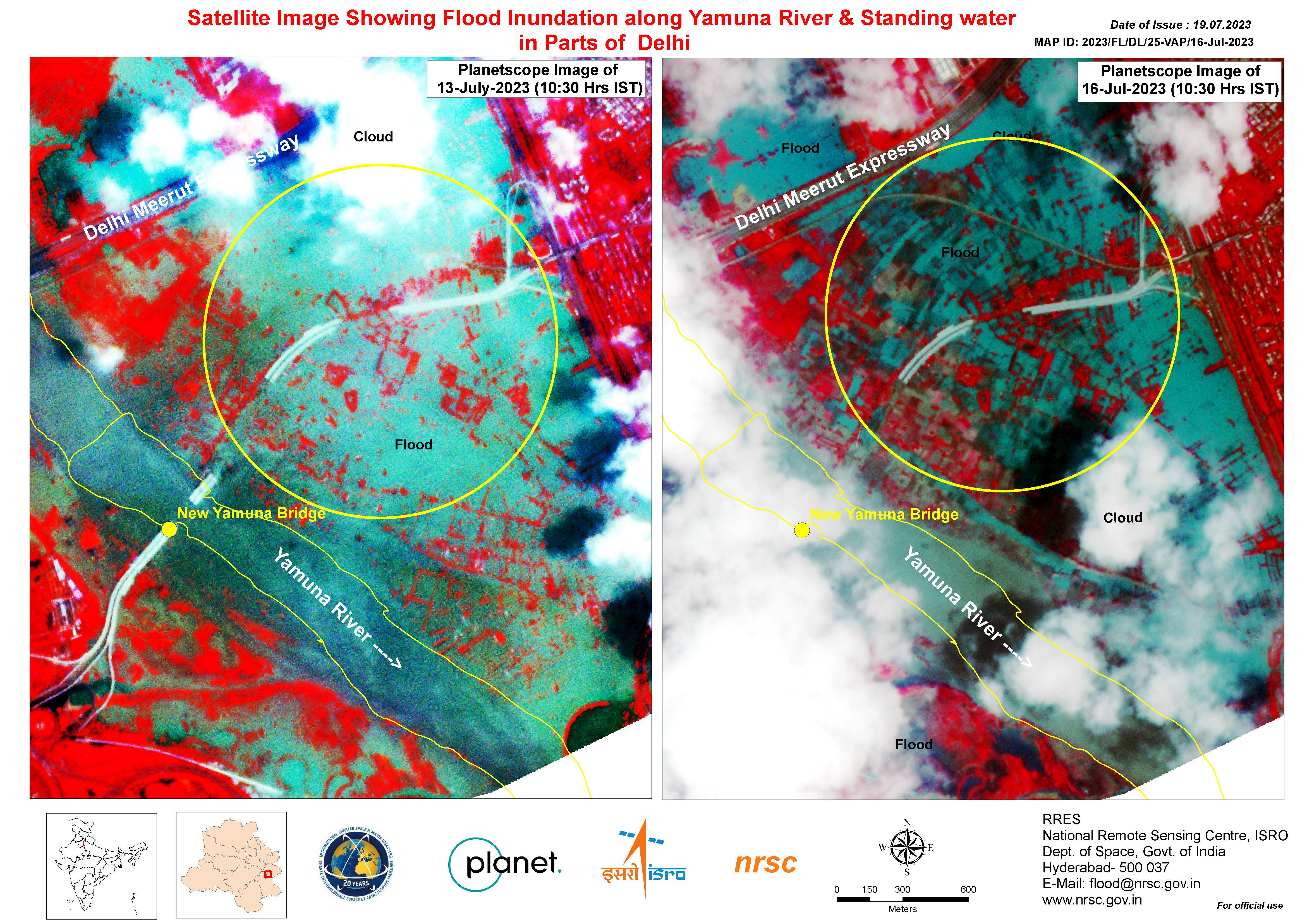
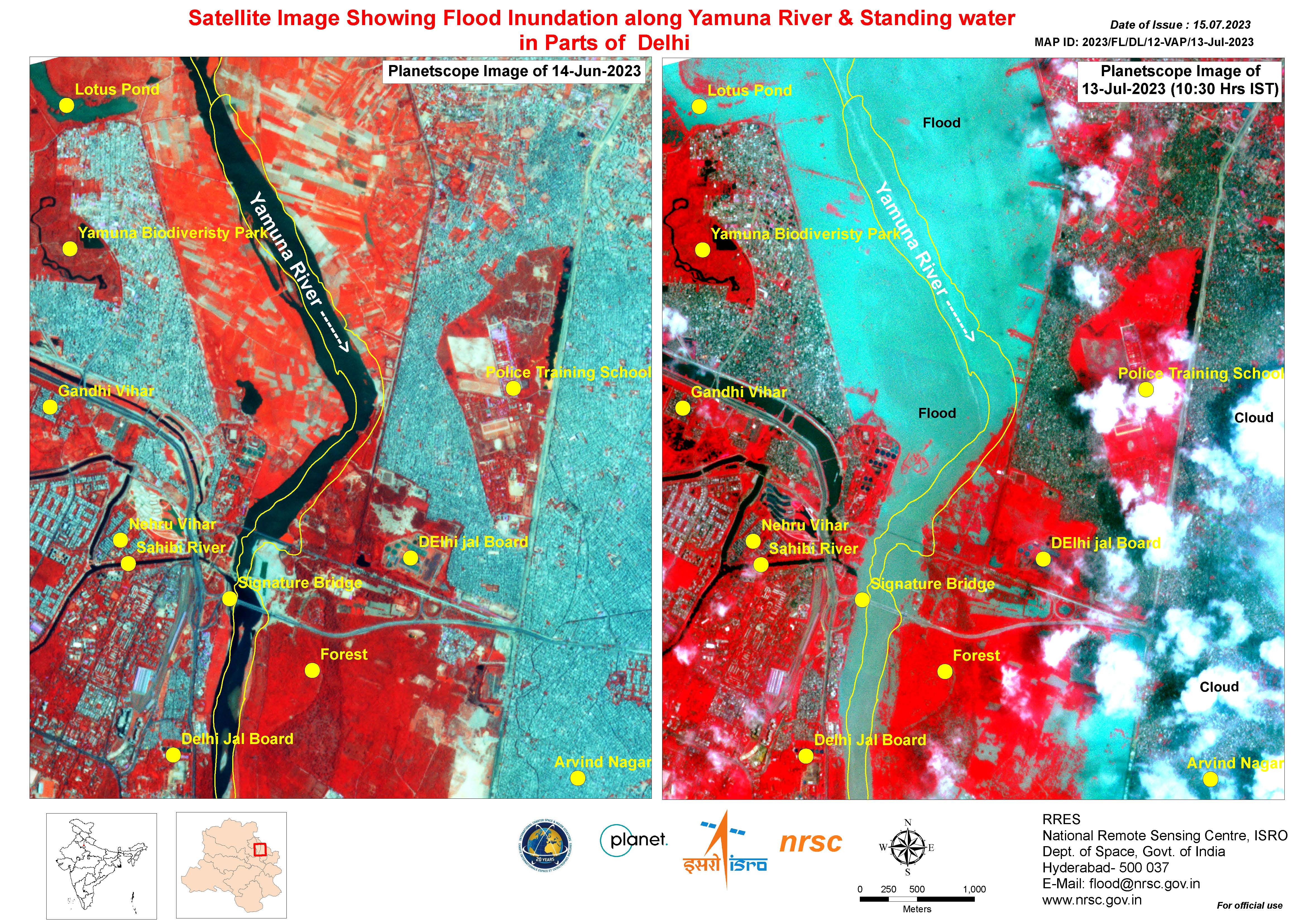
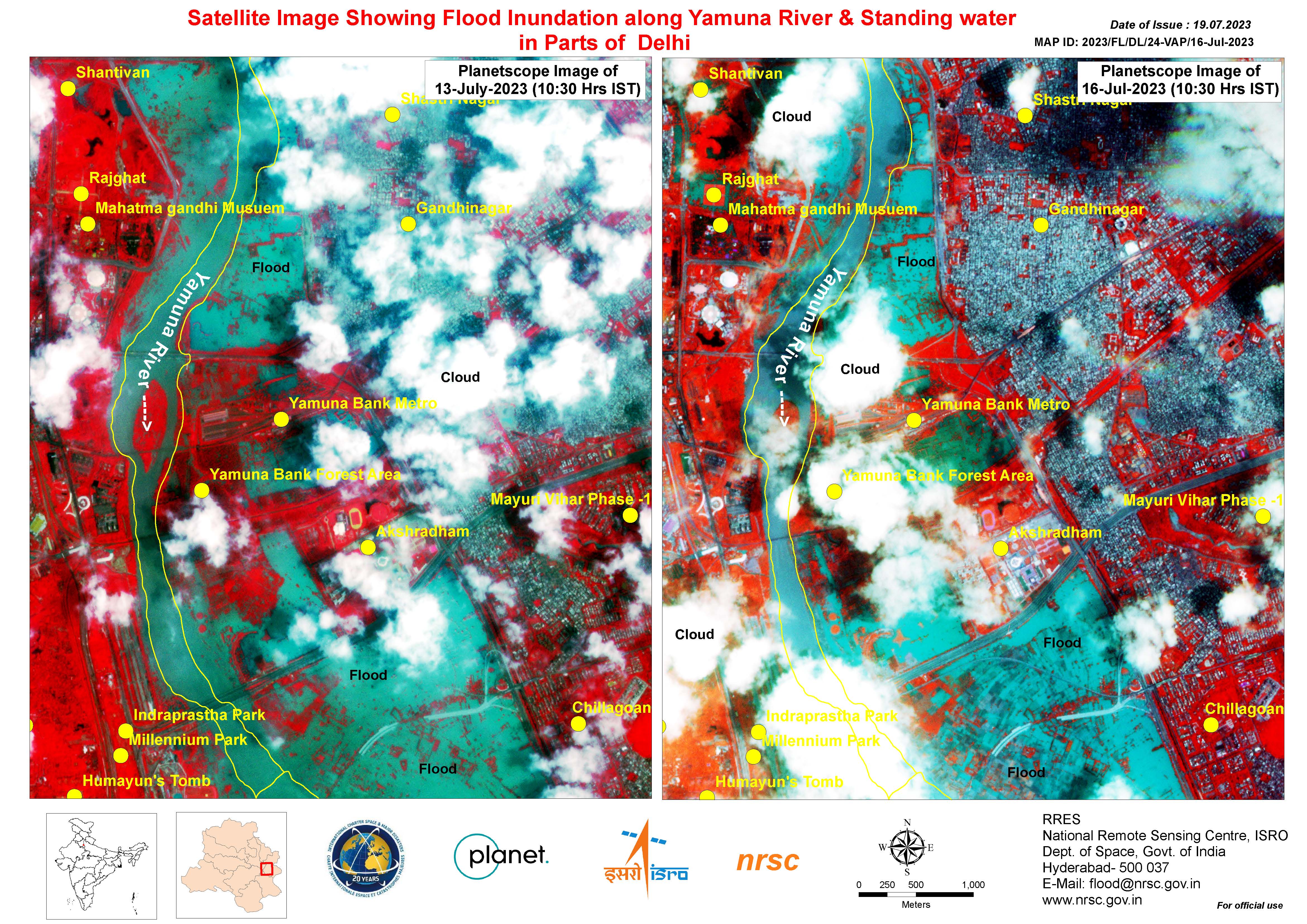
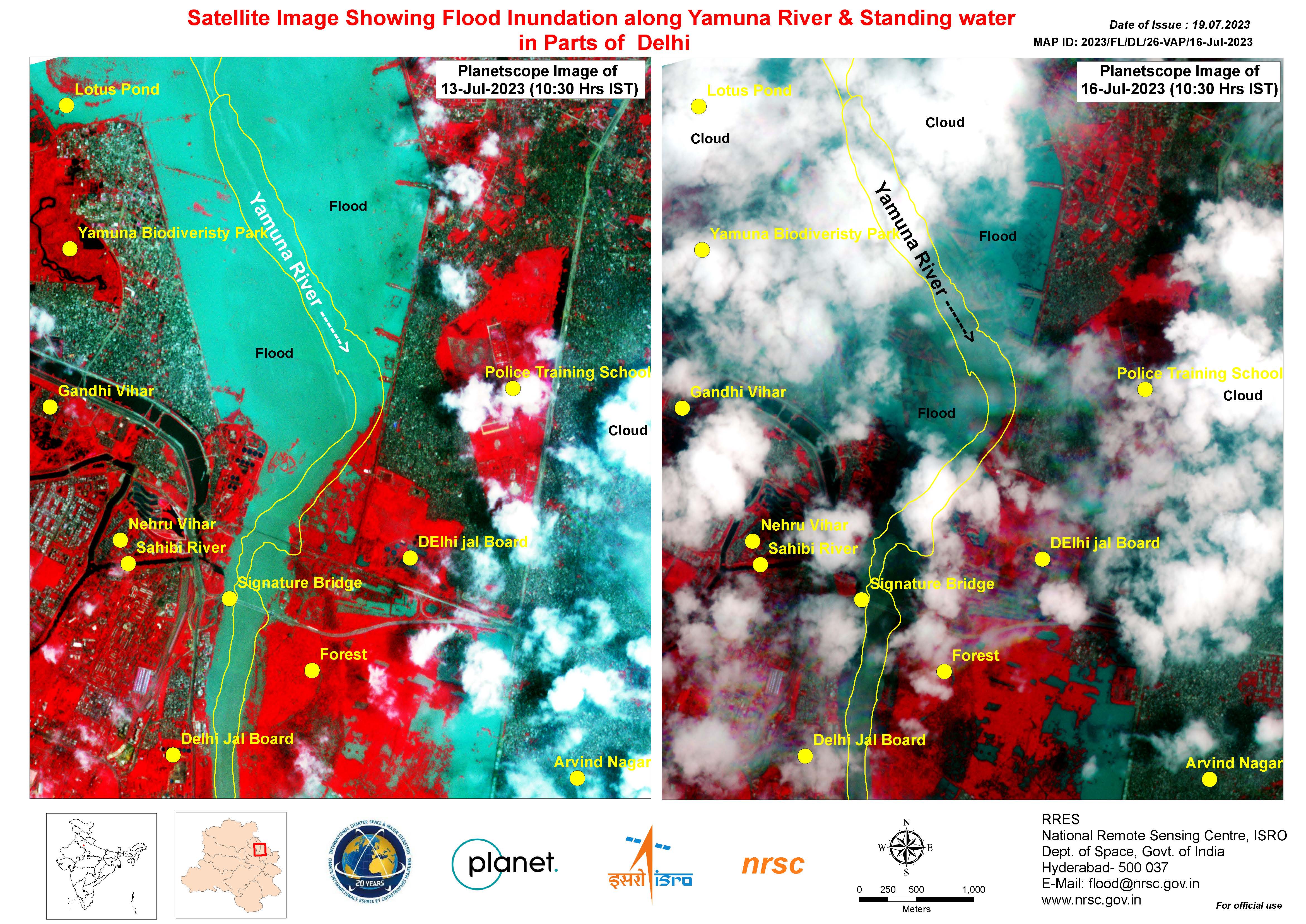
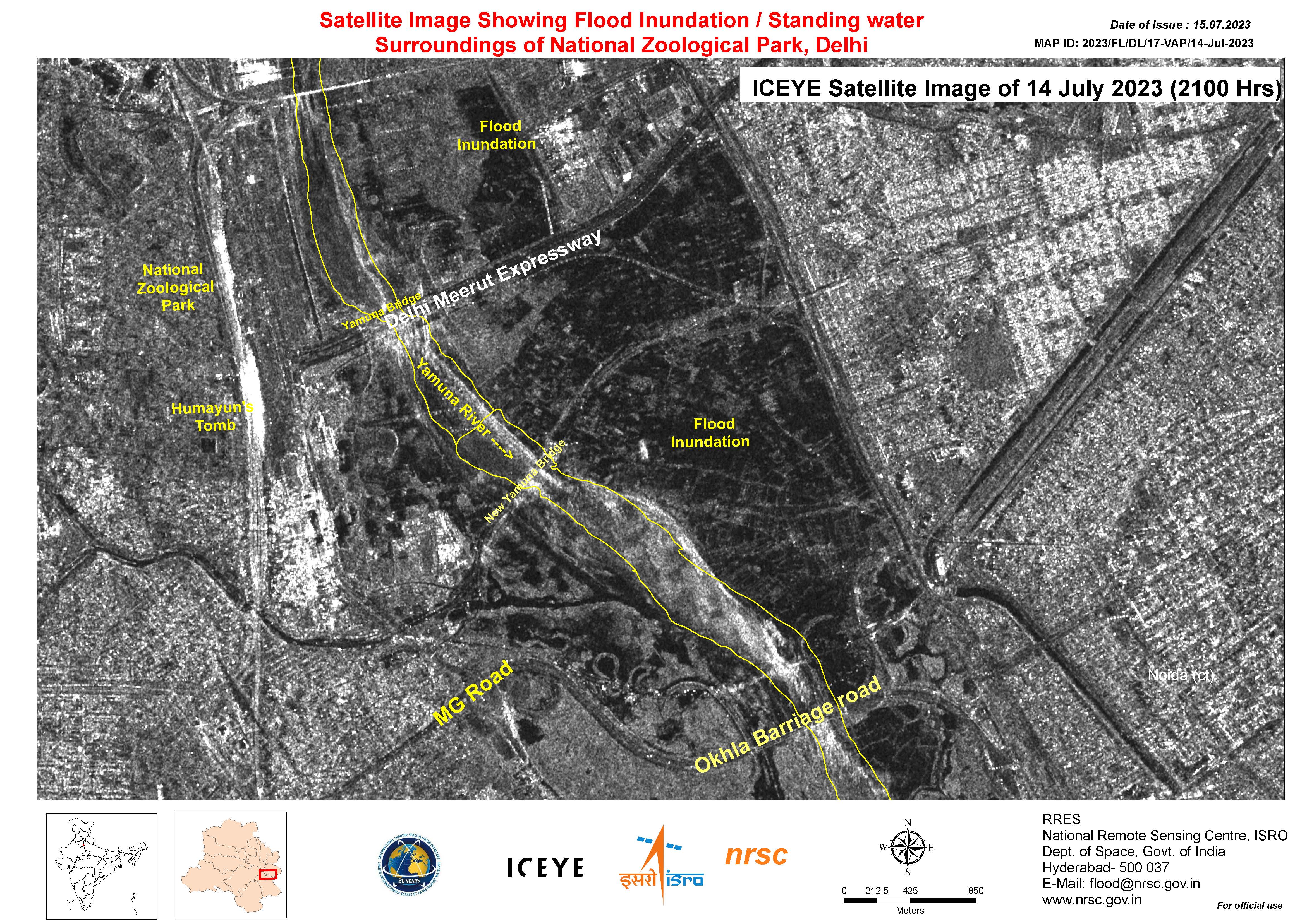
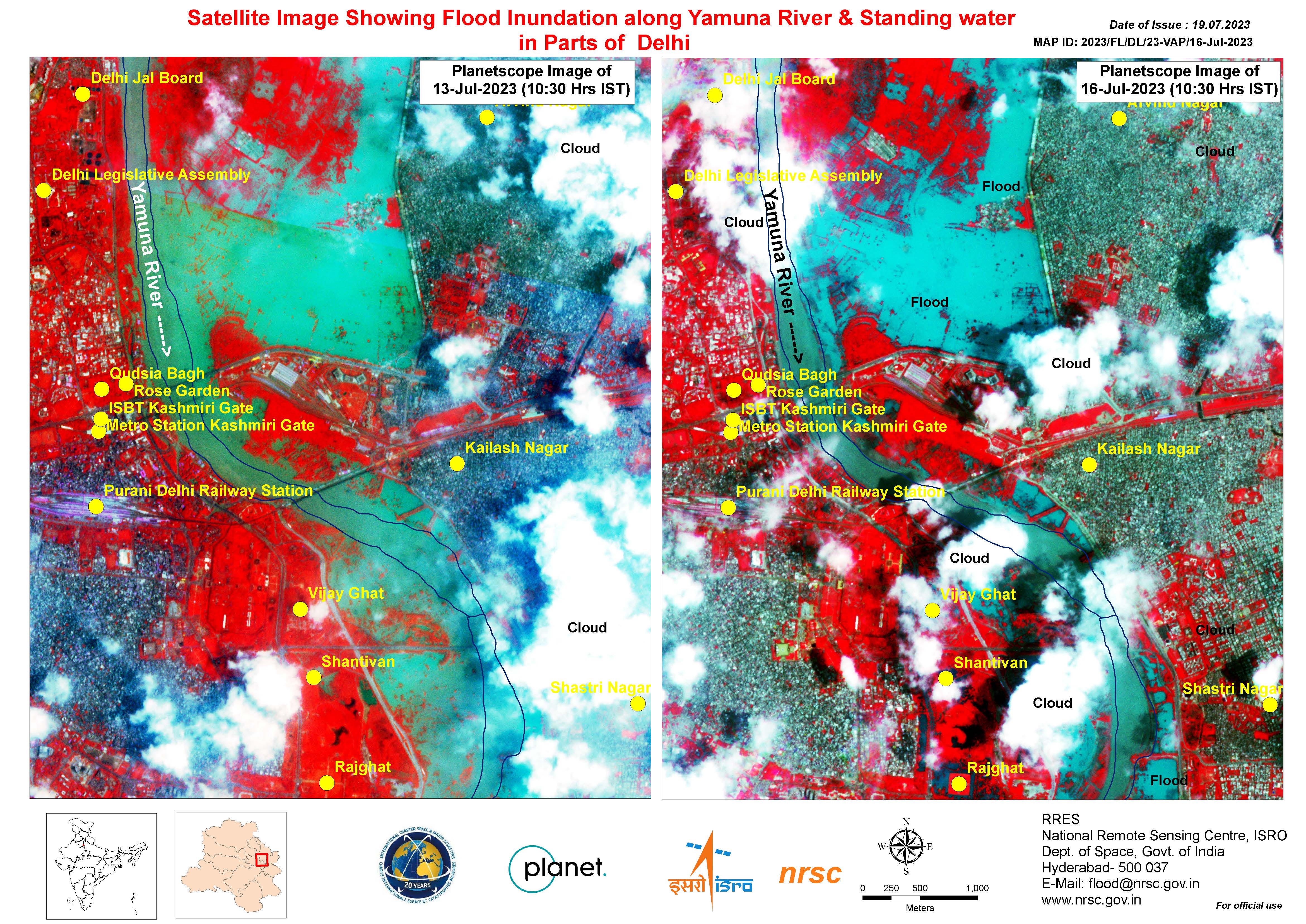
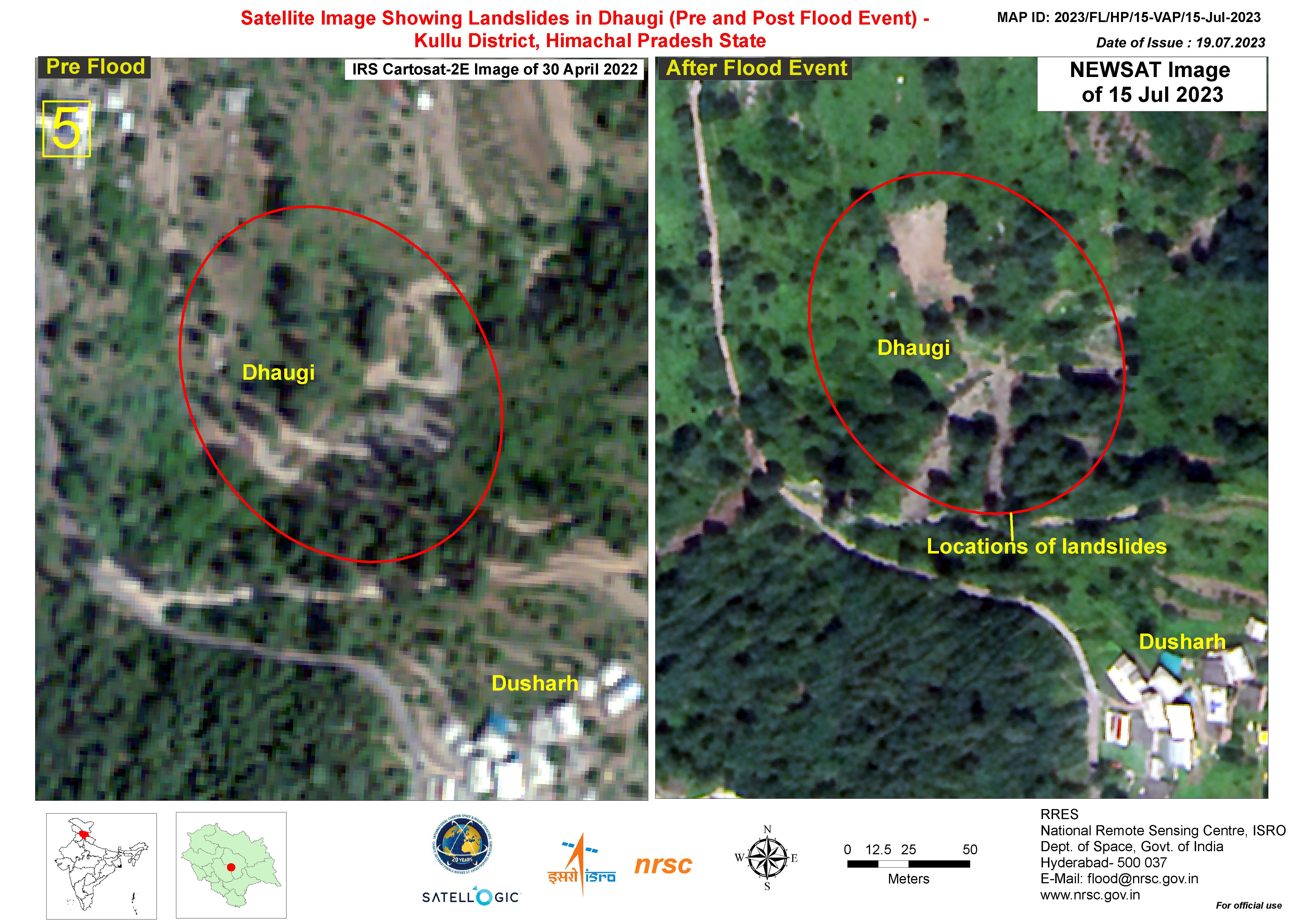
Satellite Image Showing Landslides in Dhaugi (Pre and Post Flood Event) - Kullu District, Himachal Pradesh State
Direitos autorais: © Satellogic (2023)
Map produced by the National Remote Sensing Centre, ISRO.
Information about the Product
Adquirida: 15/07/2023
Fonte: NewSat
Categoria: Reference Map
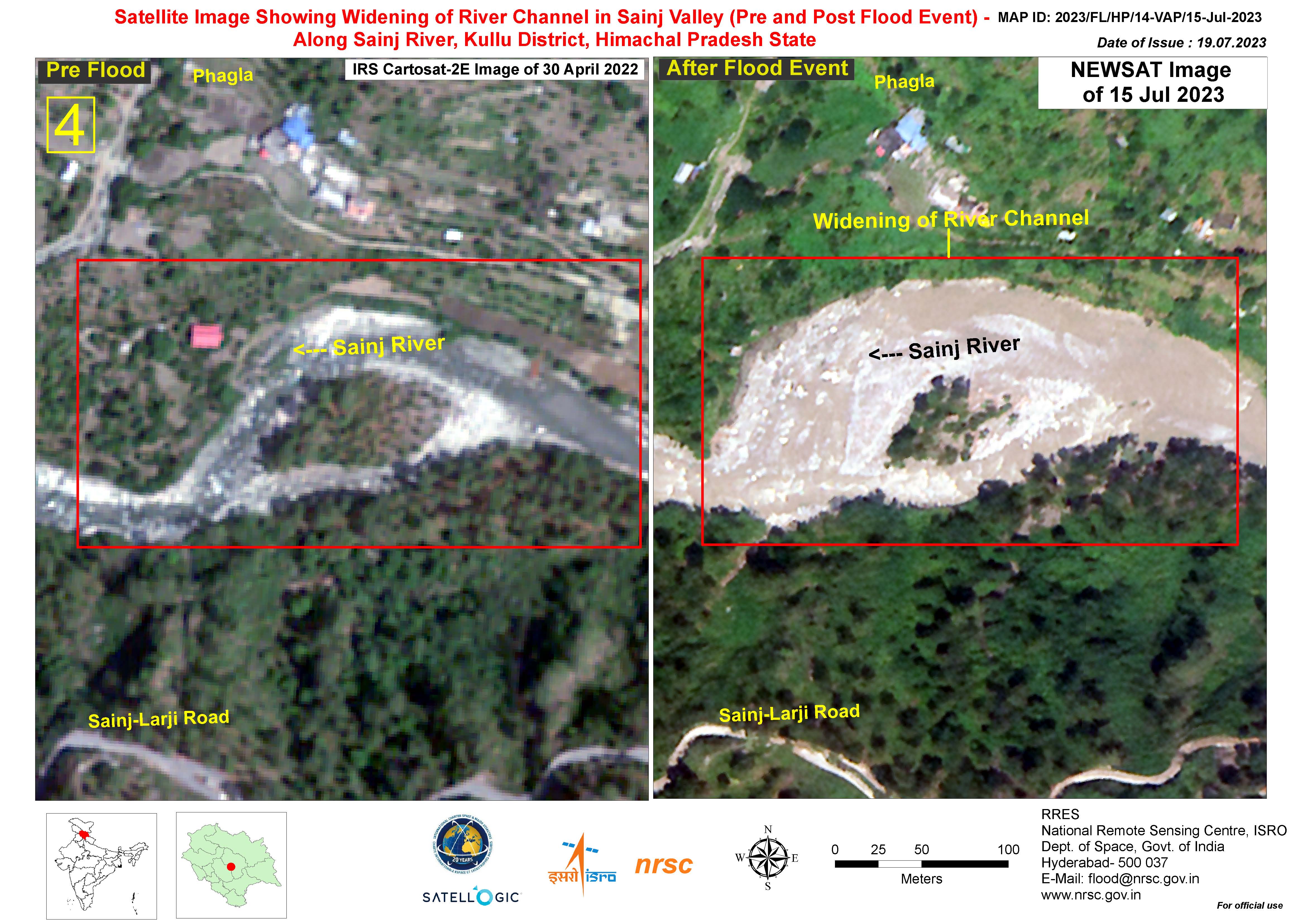
Satellite Image Showing Widening of River Channel in Sainj Valley (Pre and Post Flood Event) - Along Sainj River, Kullu District, Himachal Pradesh State
Direitos autorais: © Satellogic (2023)
Map produced by the National Remote Sensing Centre, ISRO.
Information about the Product
Adquirida: 15/07/2023
Fonte: NewSat
Categoria: Reference Map
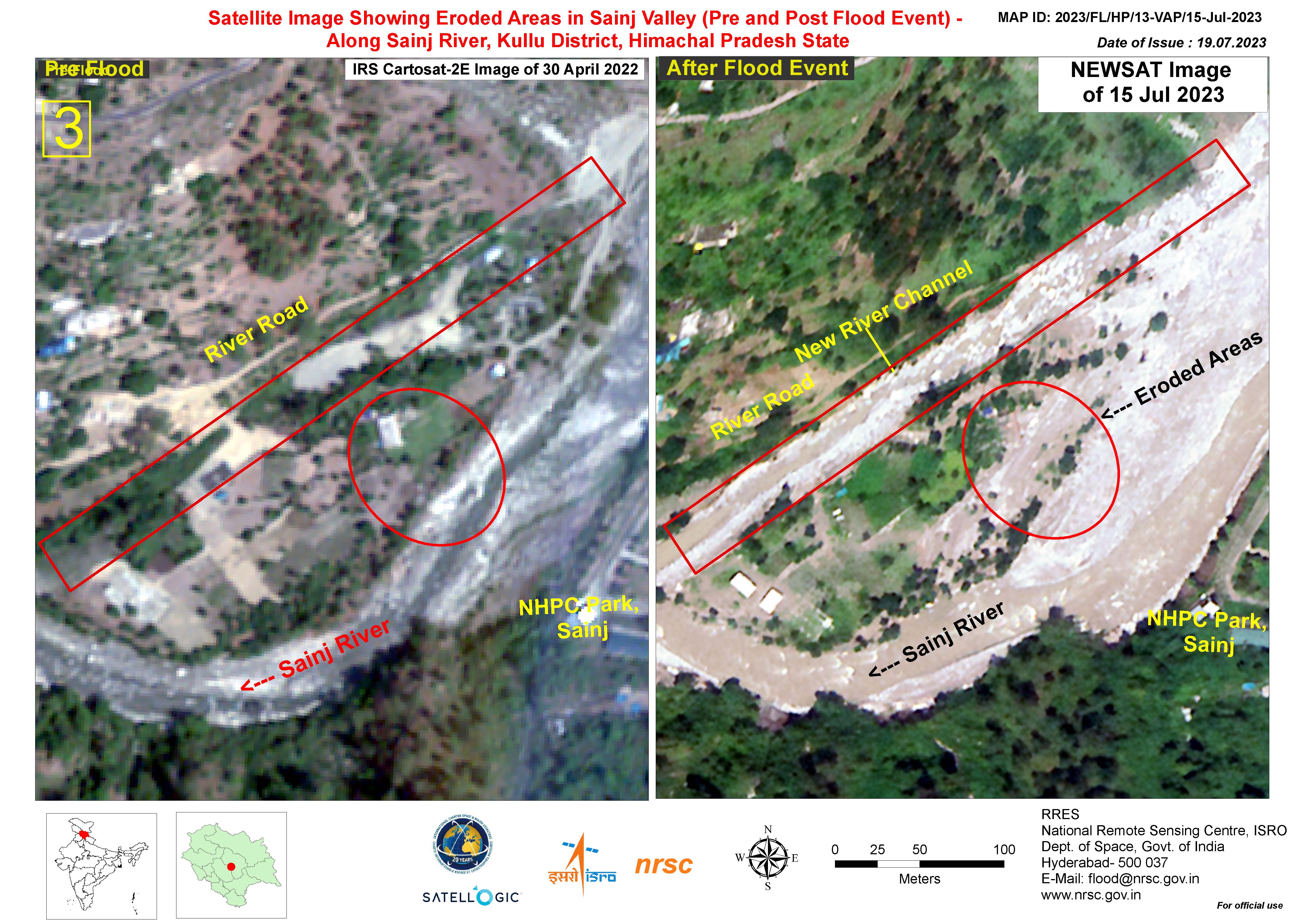
Satellite Image Showing Eroded Areas in the Sainj Valley (Pre and Post Flood Event) - Along the Sainj River, Kullu District, Himachal Pradesh State
Direitos autorais: © Satellogic (2023)
Map produced by the National Remote Sensing Centre, ISRO.
Information about the Product
Adquirida: 15/07/2023
Fonte: NewSat
Categoria: Reference Map
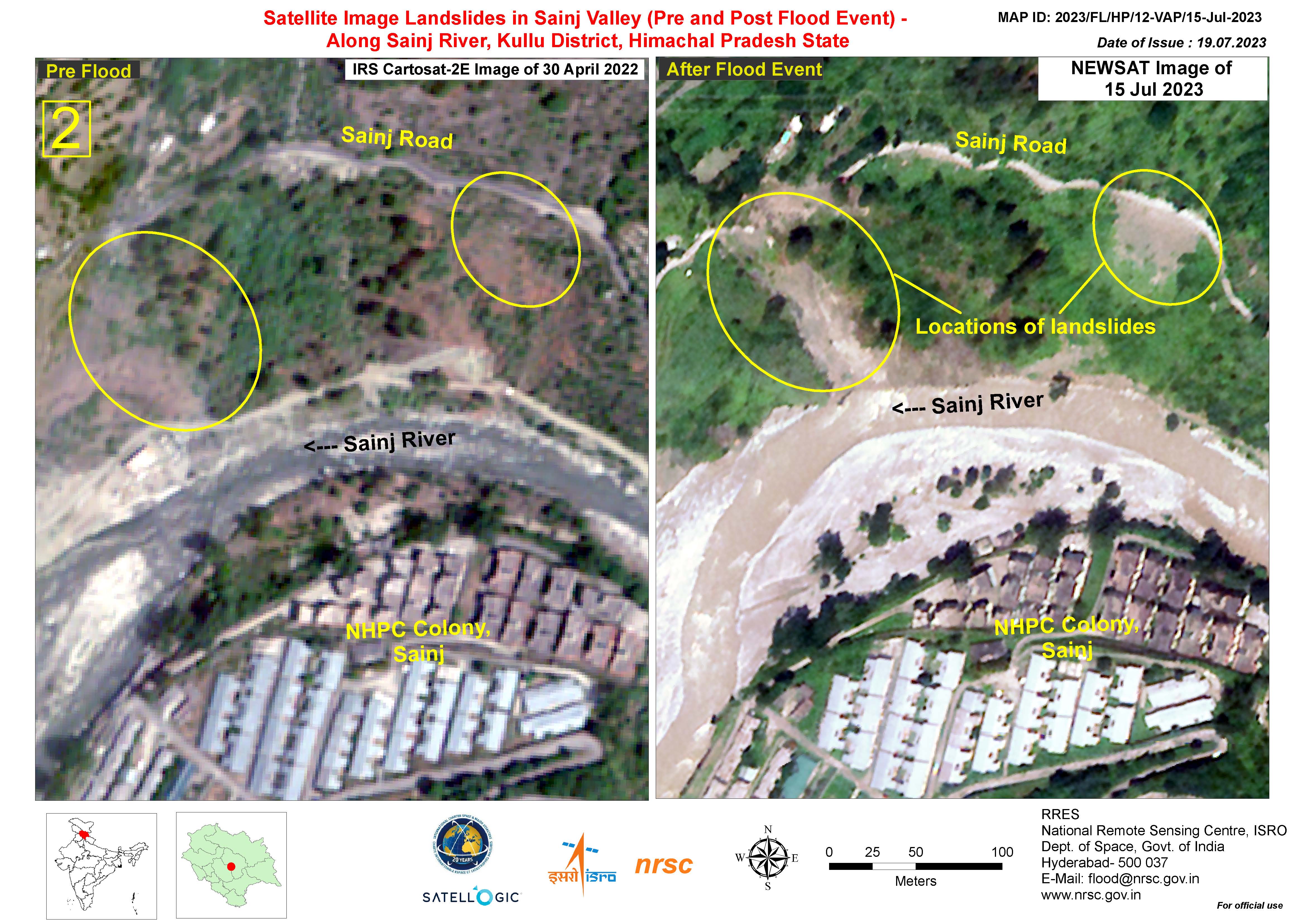
Satellite Image Landslides in Sainj Valley (Pre and Post Flood Event) - Along Sainj River, Kullu District, Himachal Pradesh State
Direitos autorais: © Satellogic (2023)
Map produced by the National Remote Sensing Centre, ISRO.
Information about the Product
Adquirida: 15/07/2023
Fonte: NewSat
Categoria: Reference Map
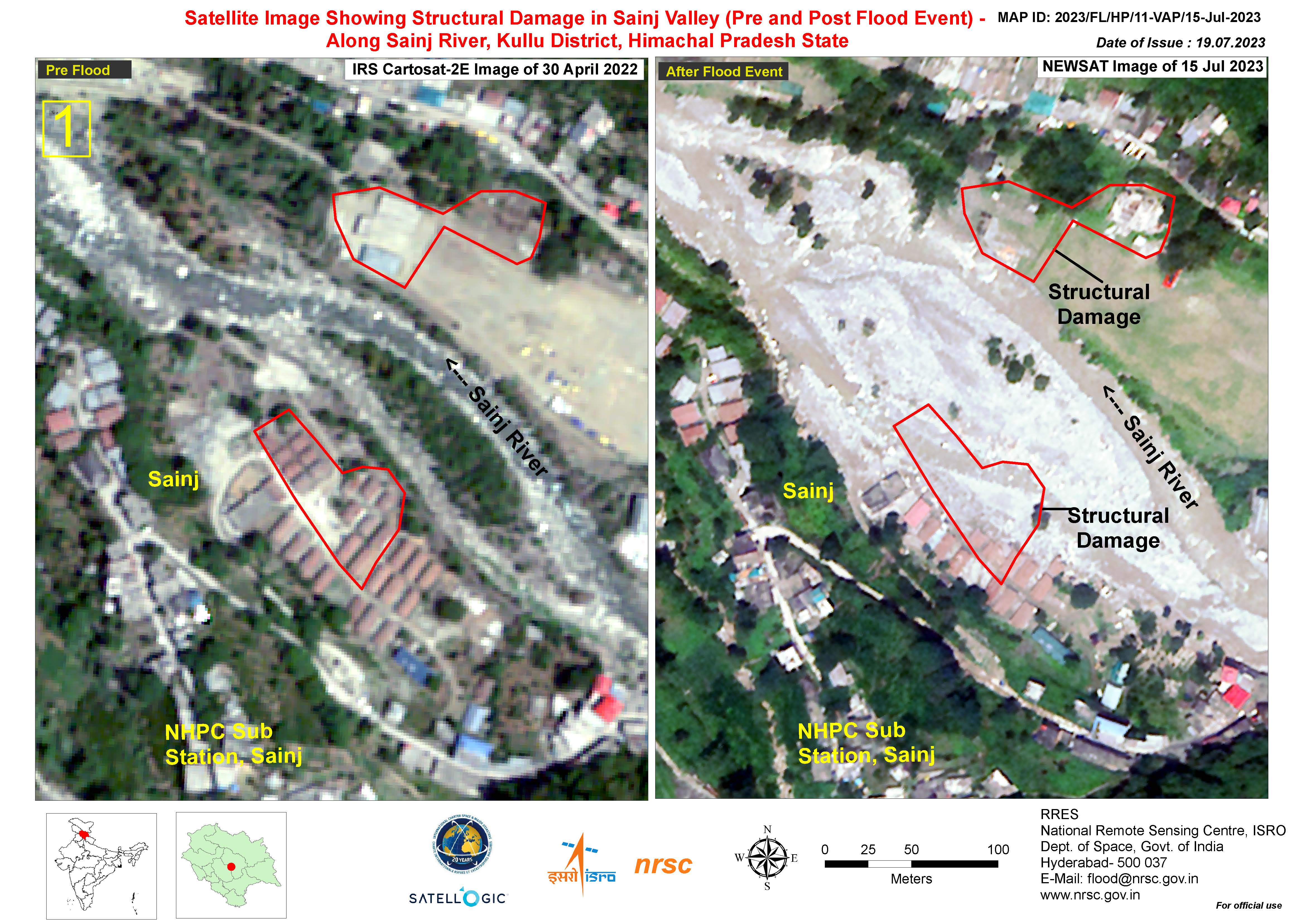
Satellite Image Showing Structural Damage in the Sainj Valley (Pre and Post Flood Event) - Along the Sainj River, Kullu District, Himachal Pradesh State
Direitos autorais: © Satellogic (2023)
Map produced by the National Remote Sensing Centre, ISRO.
Information about the Product
Adquirida: 15/07/2023
Fonte: NewSat
Categoria: Reference Map
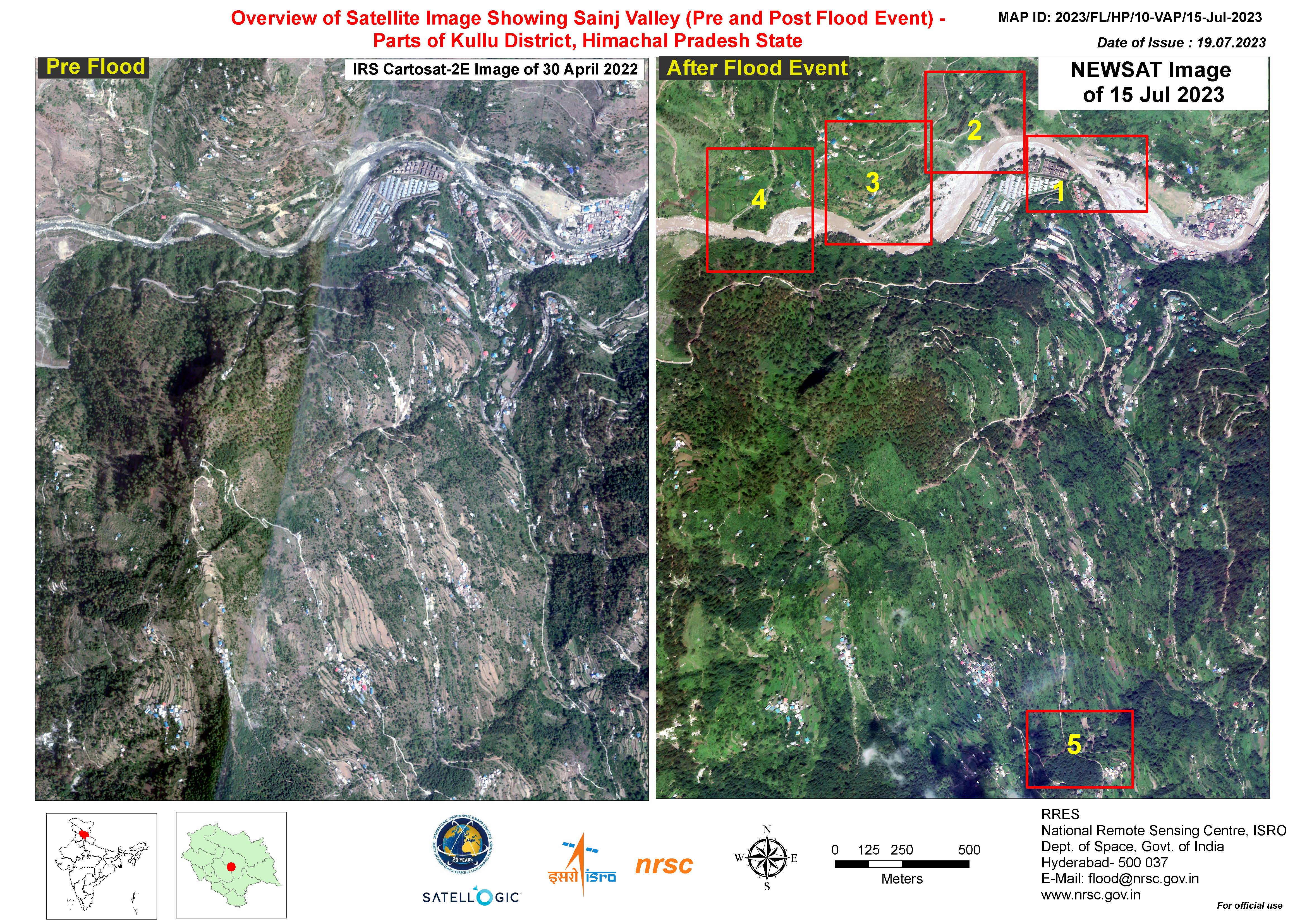
Overview of Satellite Image Showing Sainj Valley (Pre and Post Flood Event) - Parts of the Kullu District, Himachal Pradesh State
Direitos autorais: © Satellogic (2023)
Map produced by the National Remote Sensing Centre, ISRO.
Information about the Product
Adquirida: 15/07/2023
Fonte: NewSat
Categoria: Reference Map
Satellite Image Showing the Beas River Stretch (Pre and Post Flood Event) - Surroundings of Mandi Village, Mandi District, Himachal Pradesh State
Direitos autorais: © Satellogic (2023)
Map produced by the National Remote Sensing Centre, ISRO.
Information about the Product
Adquirida: 15/07/2023
Fonte: NewSat
Categoria: Reference Map
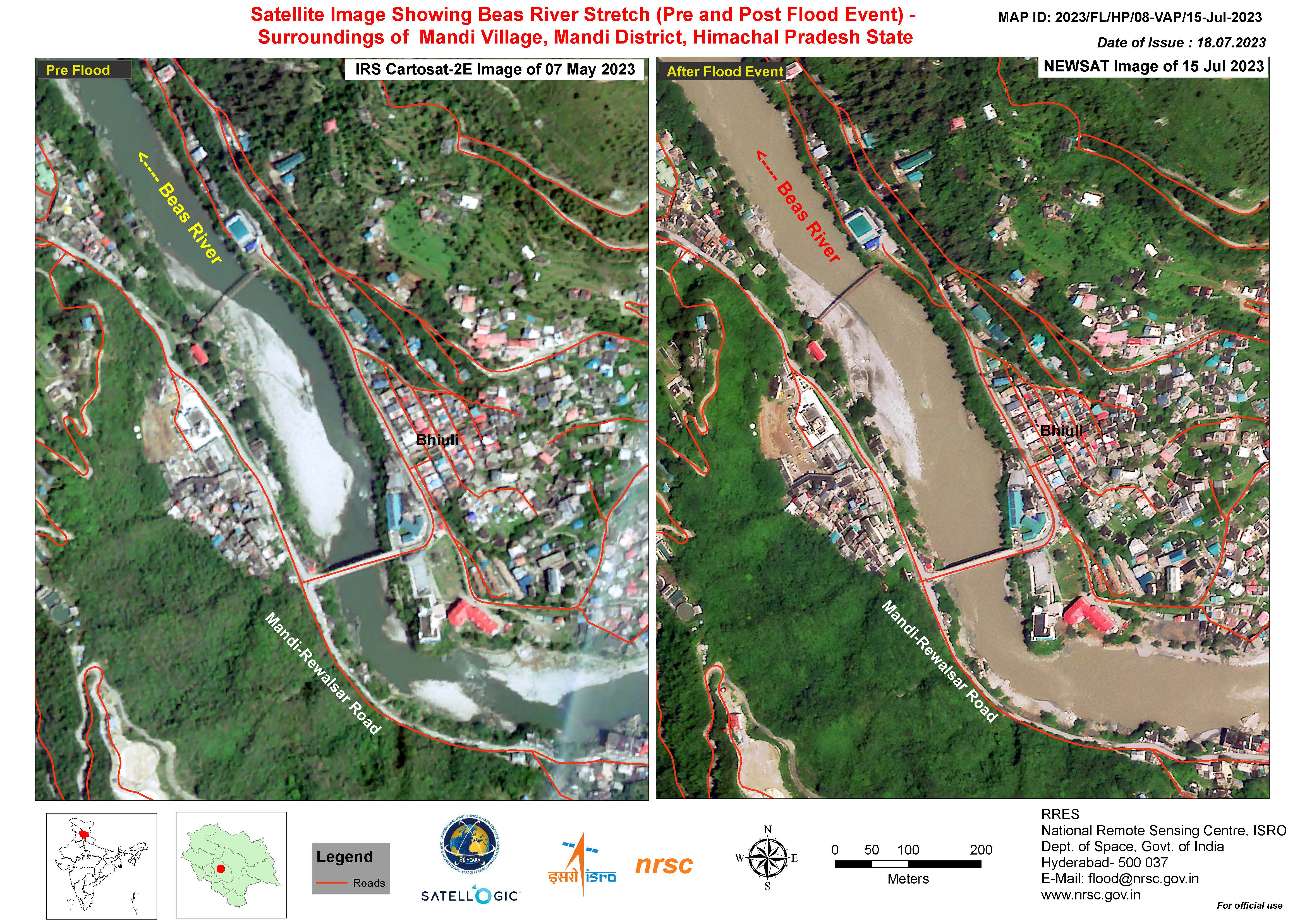
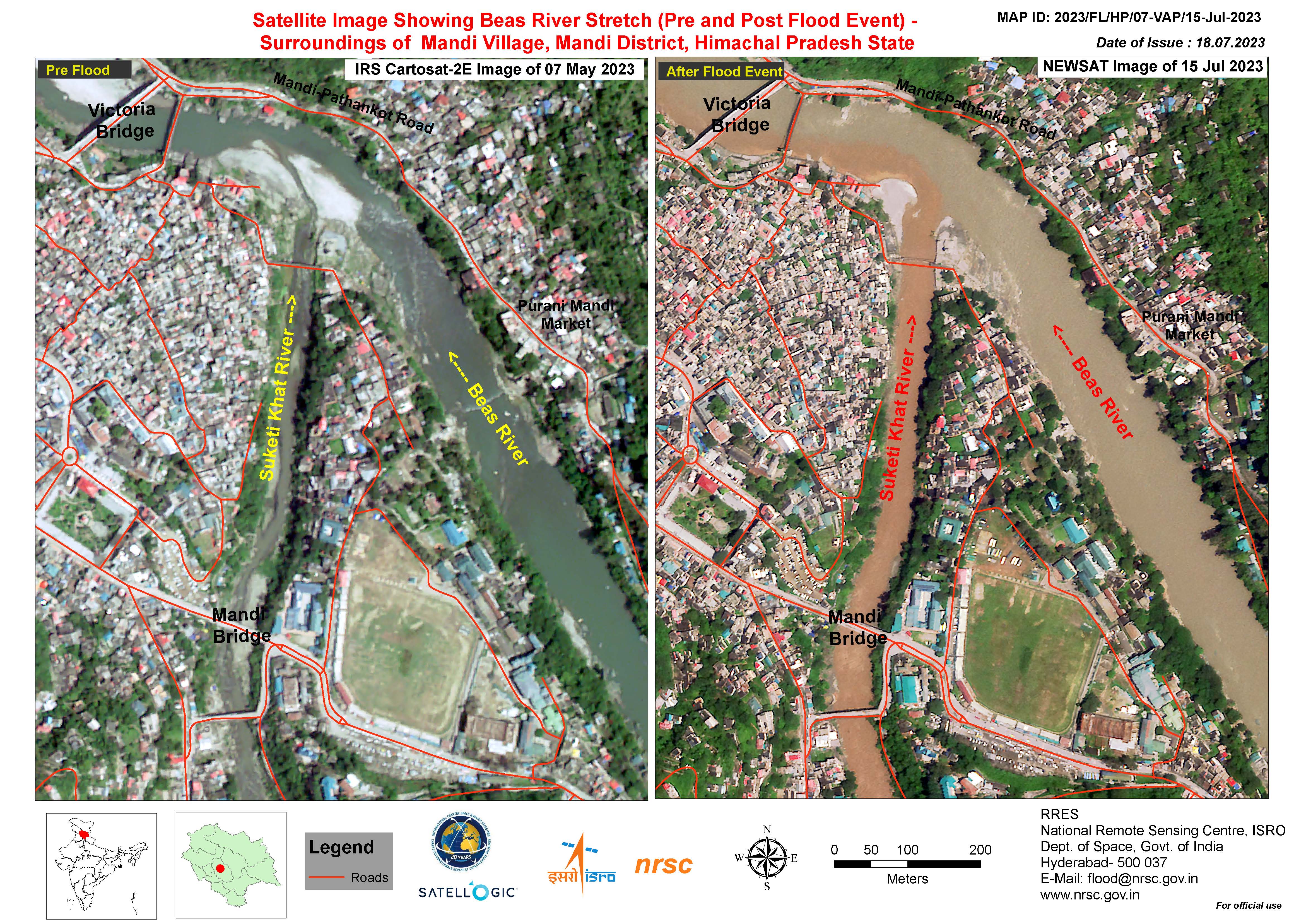
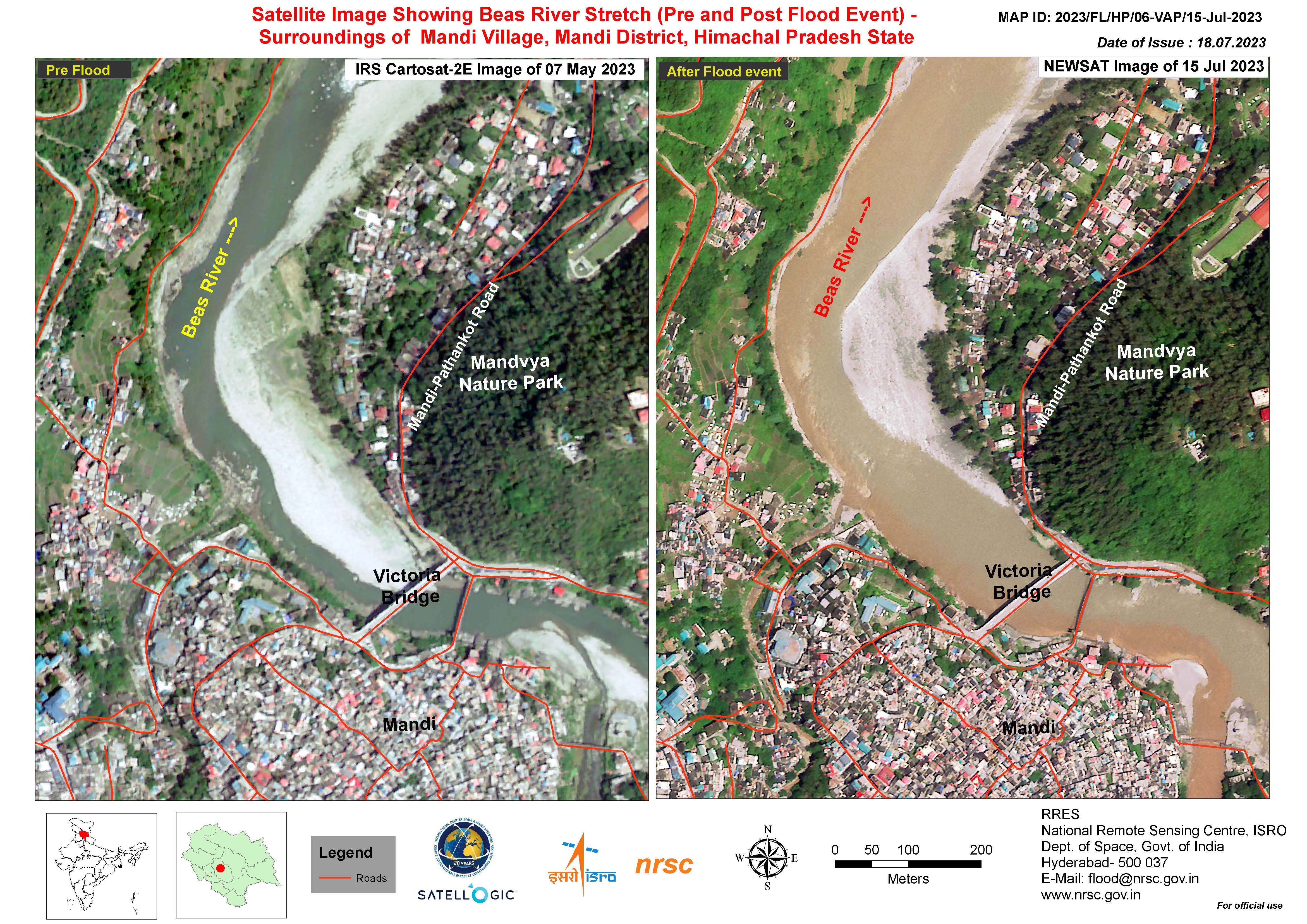
Satellite Image Showing the the Beas River Stretch (Pre and Post Flood Event) - Surroundings of Mandi Village, Mandi District, Himachal Pradesh State
Direitos autorais: © Satellogic (2023)
Map produced by the National Remote Sensing Centre, ISRO.
Information about the Product
Adquirida: 15/07/2023
Fonte: NewSat
Categoria: Reference Map
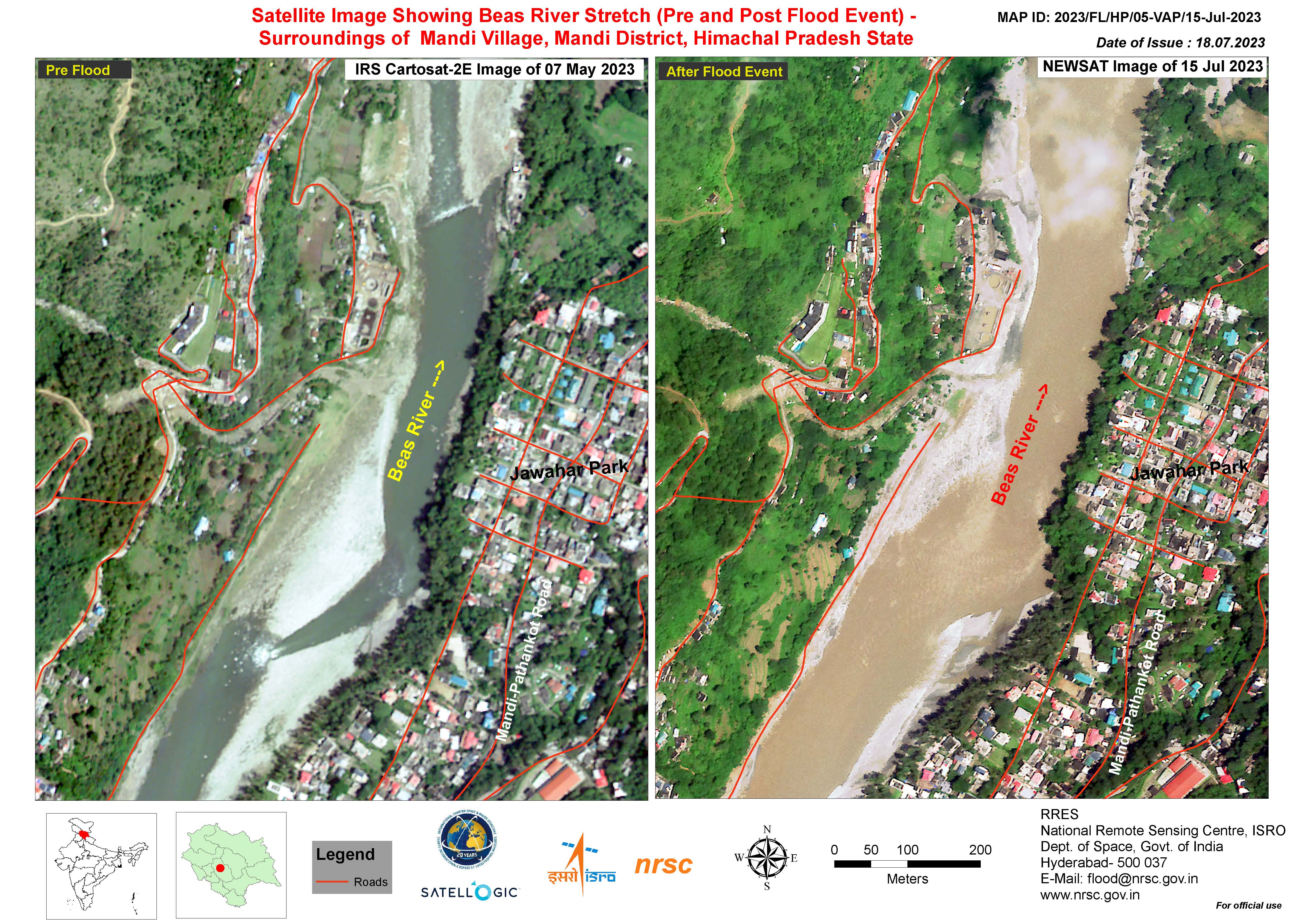
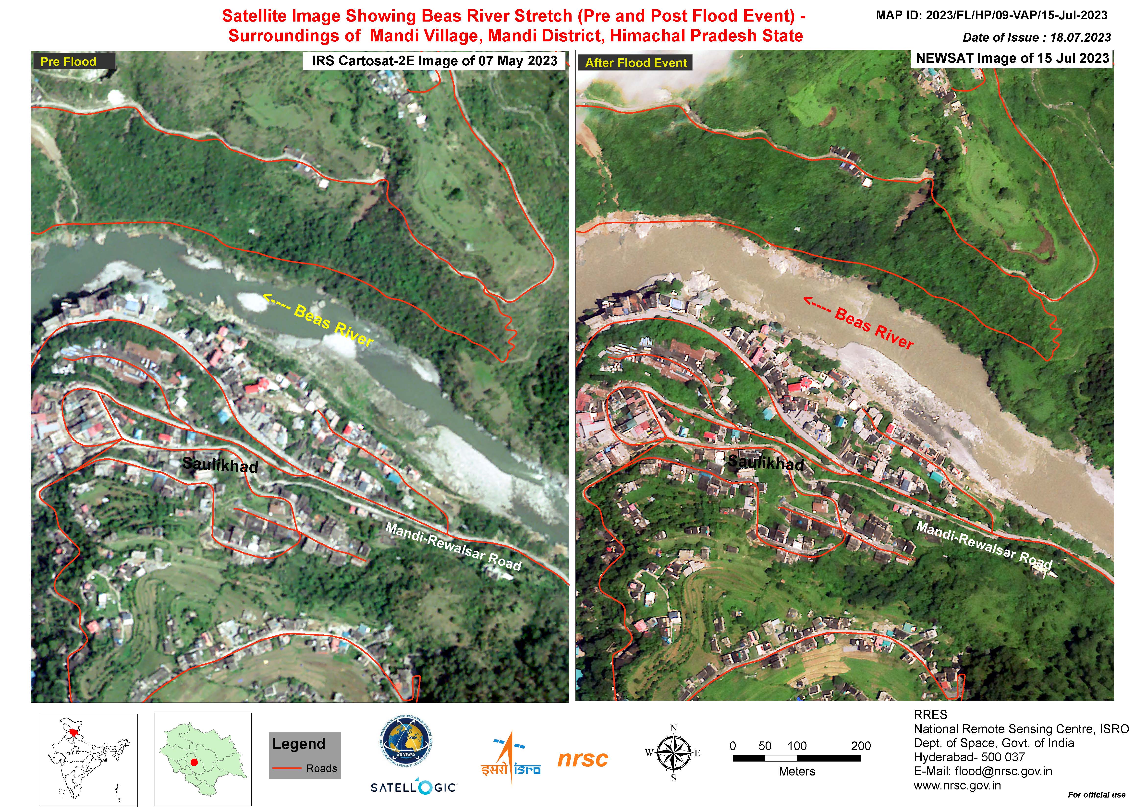
Satellite Image Showing Beas River Stretch (Pre and Post Flood Event) - Surroundings of Mandi Village, Mandi District, Himachal Pradesh State
Direitos autorais: © Satellogic (2023)
Map produced by the National Remote Sensing Centre, ISRO.
Information about the Product
Adquirida: 15/07/2023
Fonte: NewSat
Categoria: Reference Map
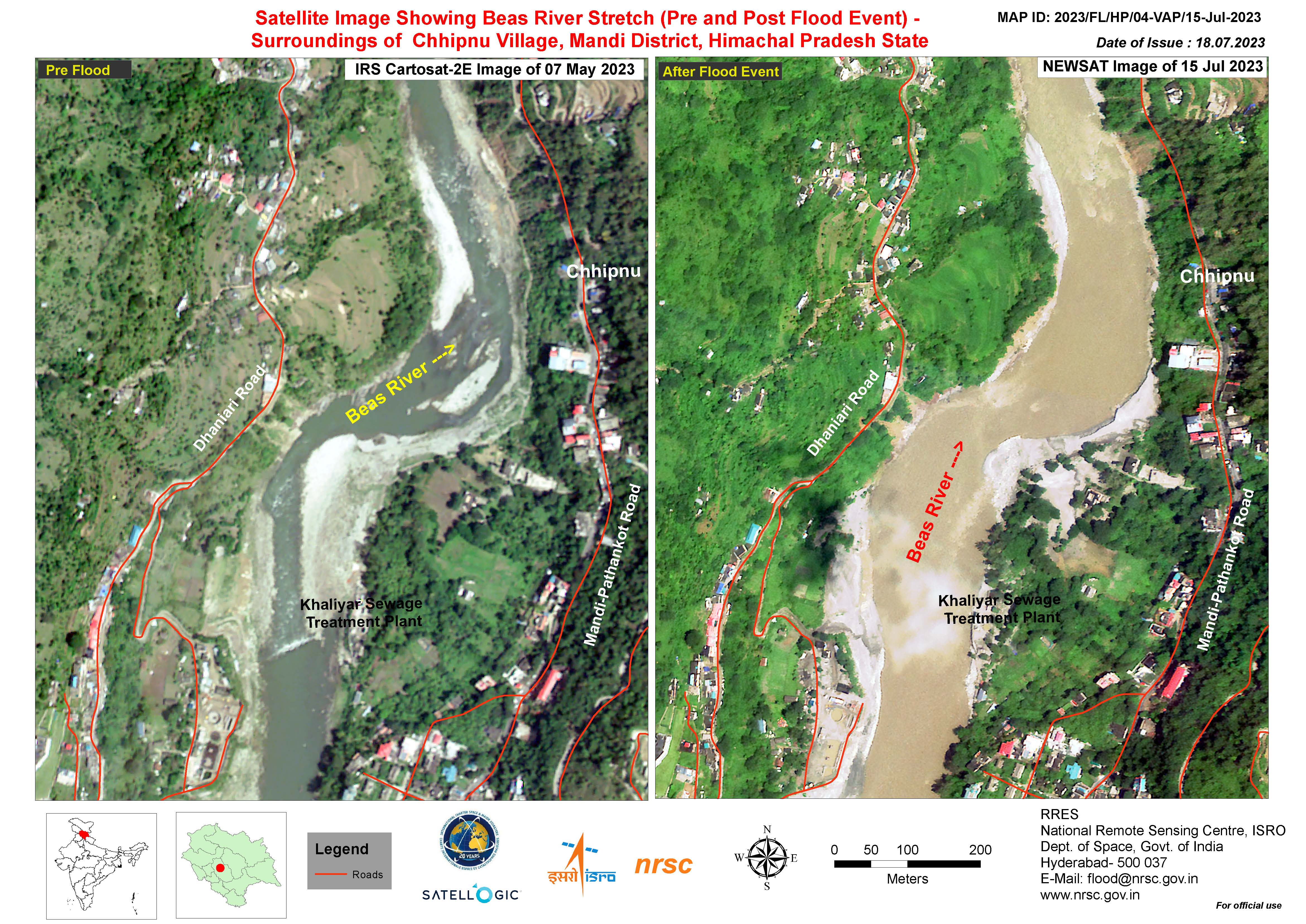
Satellite Image Showing Beas River Stretch (Pre and Post Flood Event) - Surroundings of Chhipnu Village, Mandi District, Himachal Pradesh State
Direitos autorais: © Satellogic (2023)
Map produced by the National Remote Sensing Centre, ISRO.
Information about the Product
Adquirida: 15/07/2023
Fonte: NewSat
Categoria: Reference Map
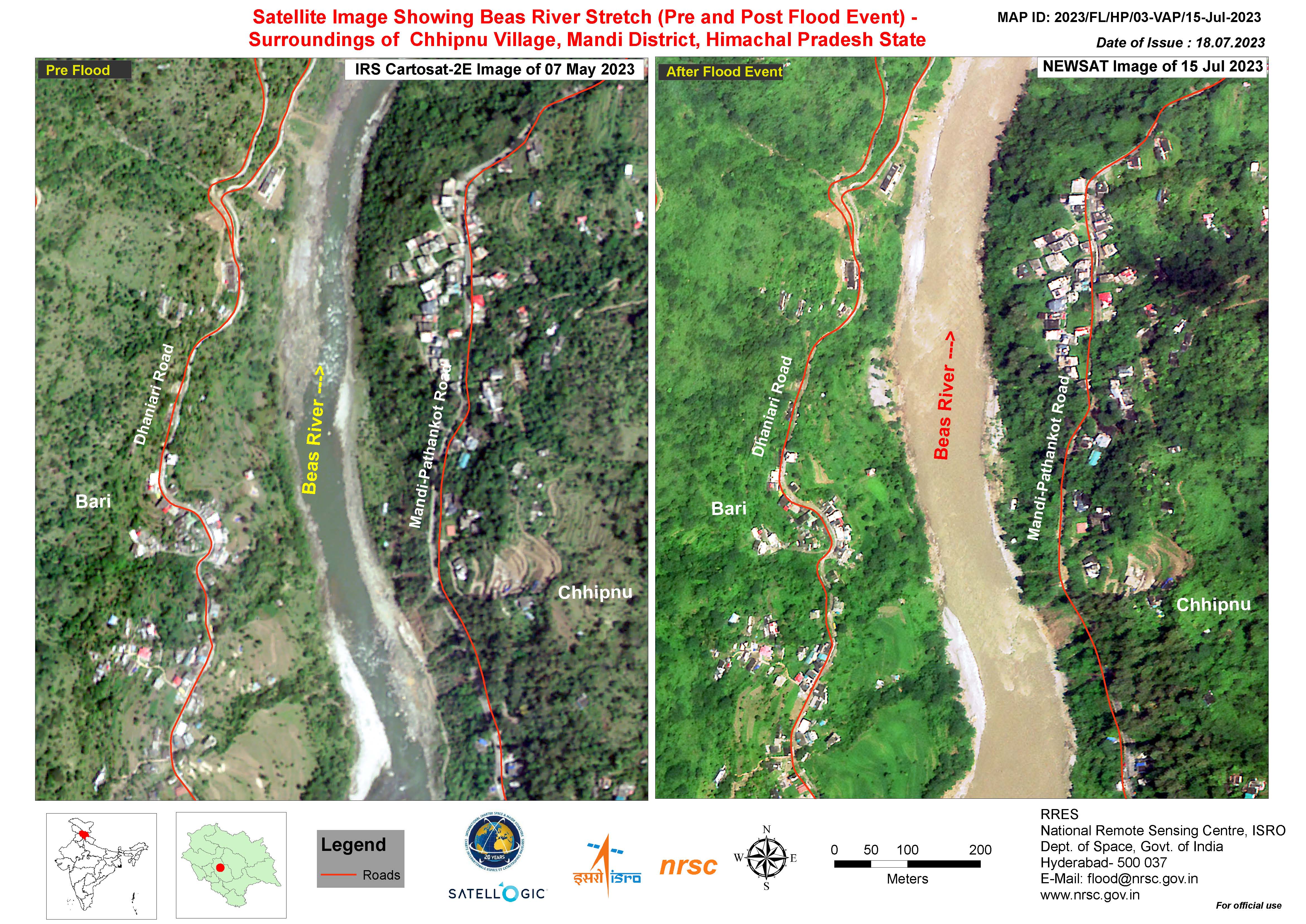
Satellite Image Showing Beas River Stretch (Pre and Post Flood Event) - Surroundings of Chhipnu Village, Mandi District, Himachal Pradesh State
Direitos autorais: © Satellogic (2023)
Map produced by the National Remote Sensing Centre, ISRO.
Information about the Product
Adquirida: 15/07/2023
Fonte: NewSat
Categoria: Reference Map
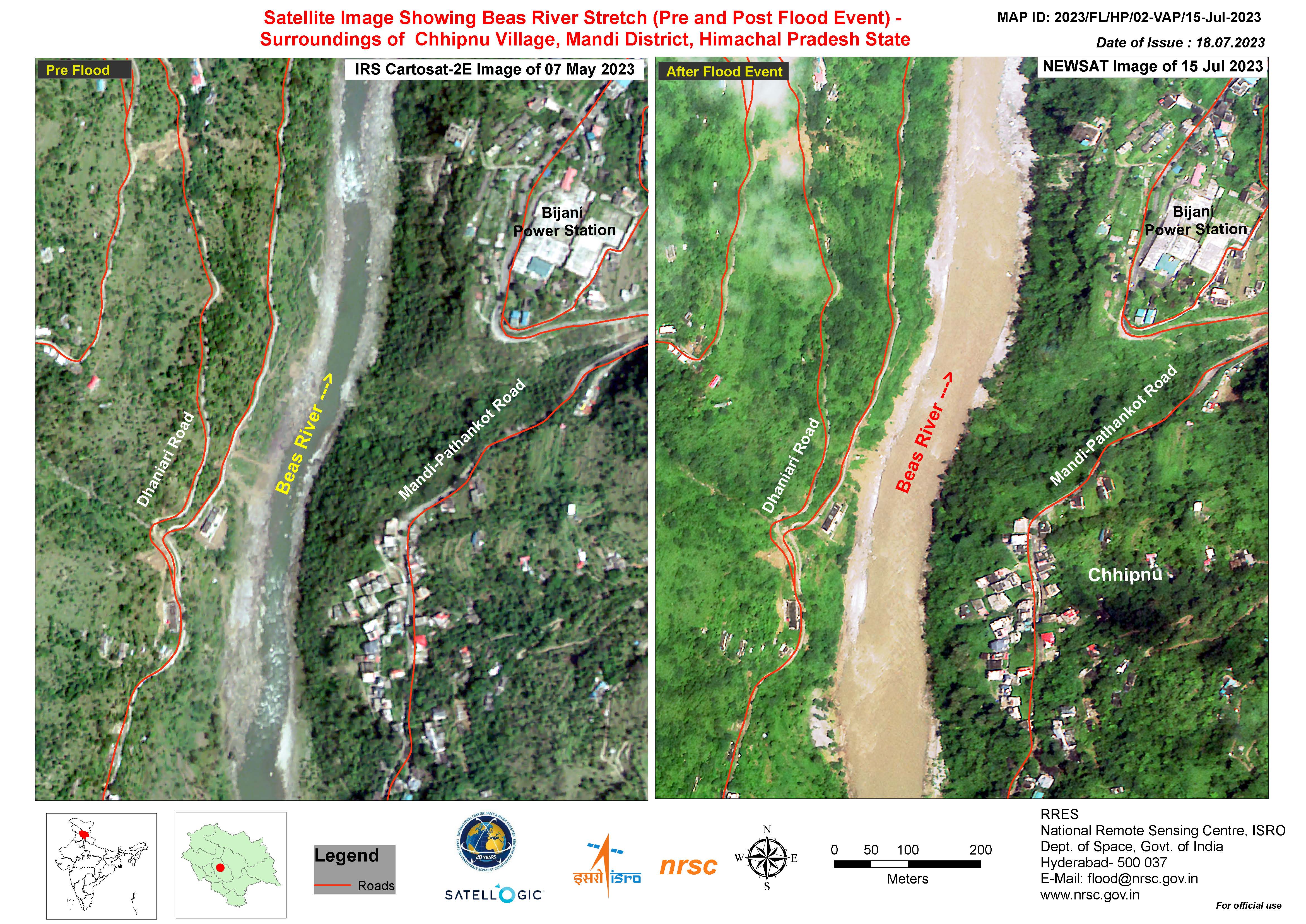
Satellite Image Showing Beas River Stretch (Pre and Post Flood Event) - Surroundings of Chhipnu Village, Mandi District, Himachal Pradesh State
Direitos autorais: © Satellogic (2023)
Map produced by the National Remote Sensing Centre, ISRO.
Information about the Product
Adquirida: 15/07/2023
Fonte: NewSat
Categoria: Reference Map
Overview of Satellite Image Showing Beas River Stretch (Pre and Post Flood Event) - Parts of Mandi District, Himachal Pradesh State
Direitos autorais: © Satellogic (2023)
Map produced by the National Remote Sensing Centre, ISRO.
Information about the Product
Adquirida: 15/07/2023
Fonte: NewSat
Categoria: Reference Map
Flood Inundation in Parts of the Punjab and Haryana States
Direitos autorais: RADARSAT Constellation Mission Imagery © Government of Canada (2023) - RADARSAT is an official mark of the Canadian Space Agency
Map produced by the National Remote Sensing Centre, ISRO.
Information about the Product
Adquirida: 15/07/2023
Fonte: RCM
Categoria: Reference Map
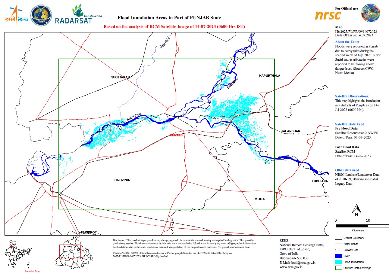
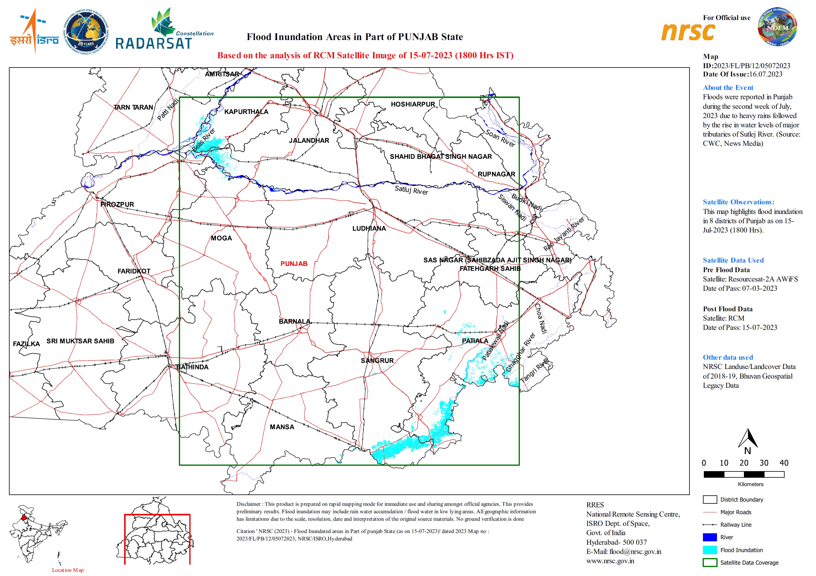
Flood Inundation Areas in Part of Punjab State
Direitos autorais: RADARSAT Constellation Mission Imagery © Government of Canada (2023) - RADARSAT is an official mark of the Canadian Space Agency
Map produced by National Remote Sensing Centre, ISRO
Information about the Product
Adquirida: 14/07/2023
Fonte: RCM
Categoria: Reference Map
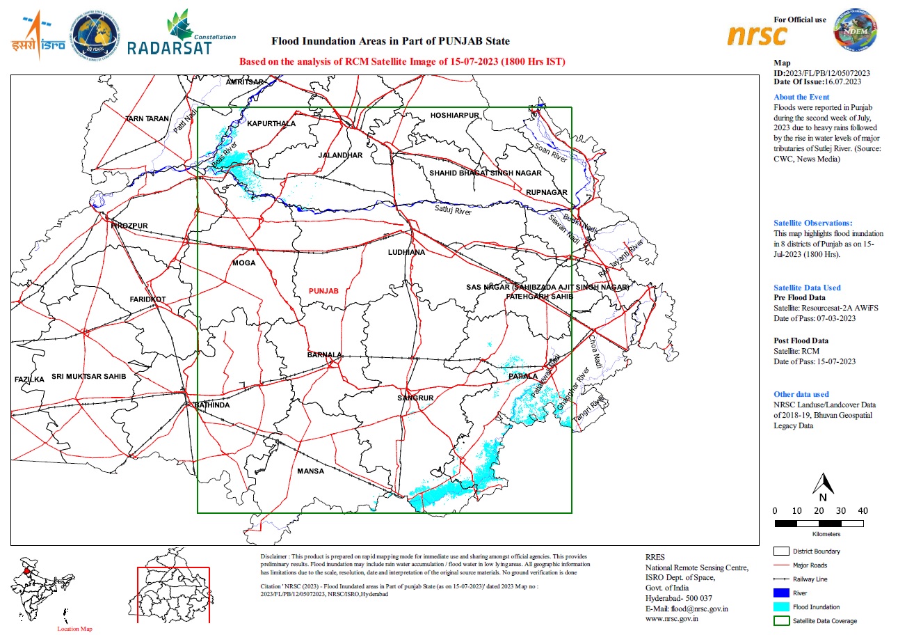
Flood Inundation Areas in Part of Punjab State
Direitos autorais: RADARSAT Constellation Mission Imagery © Government of Canada (2023) - RADARSAT is an official mark of the Canadian Space Agency
Map produced by National Remote Sensing Centre, ISRO
Information about the Product
Adquirida: 15/07/2023
Fonte: RCM
Categoria: Reference Map
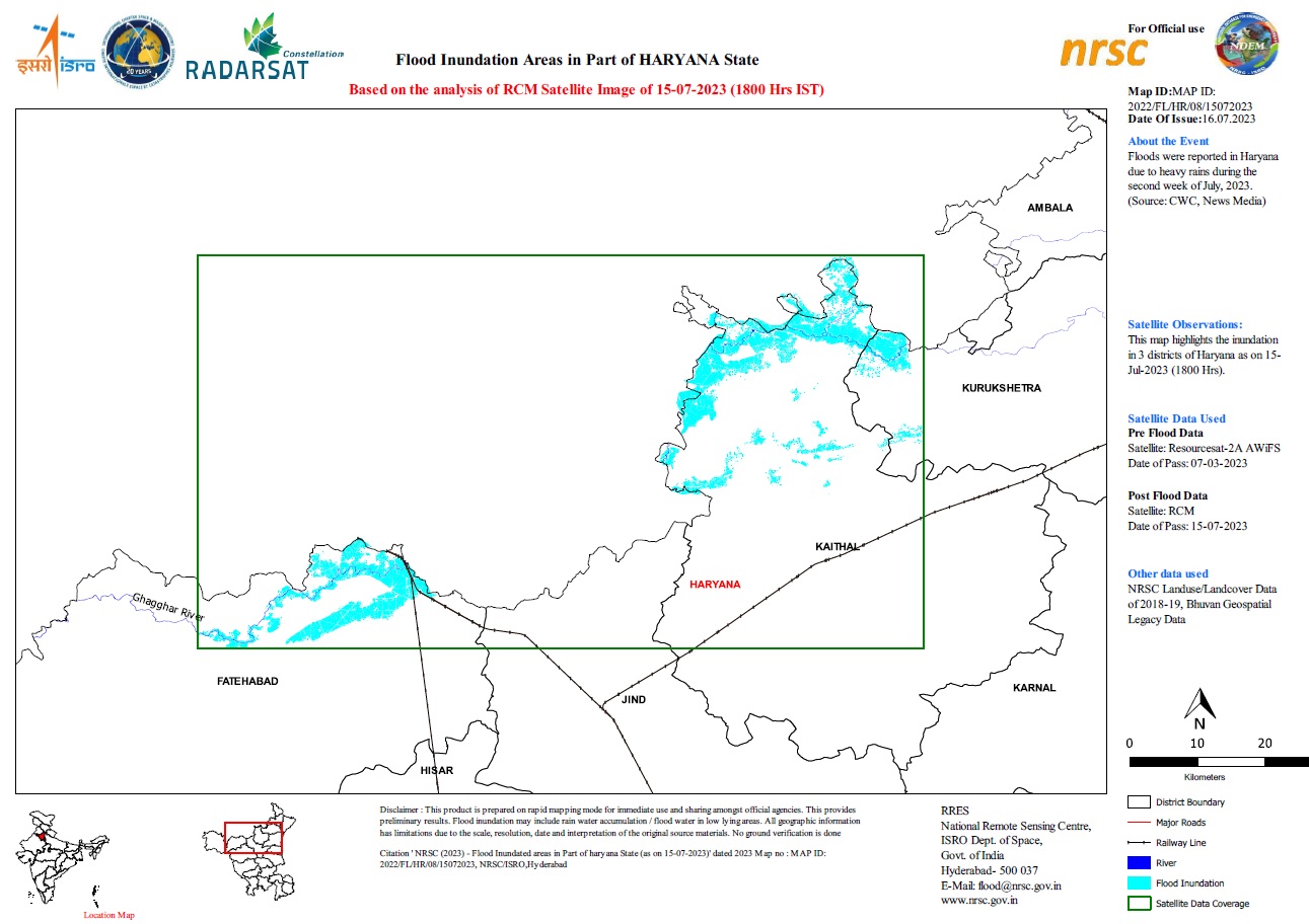
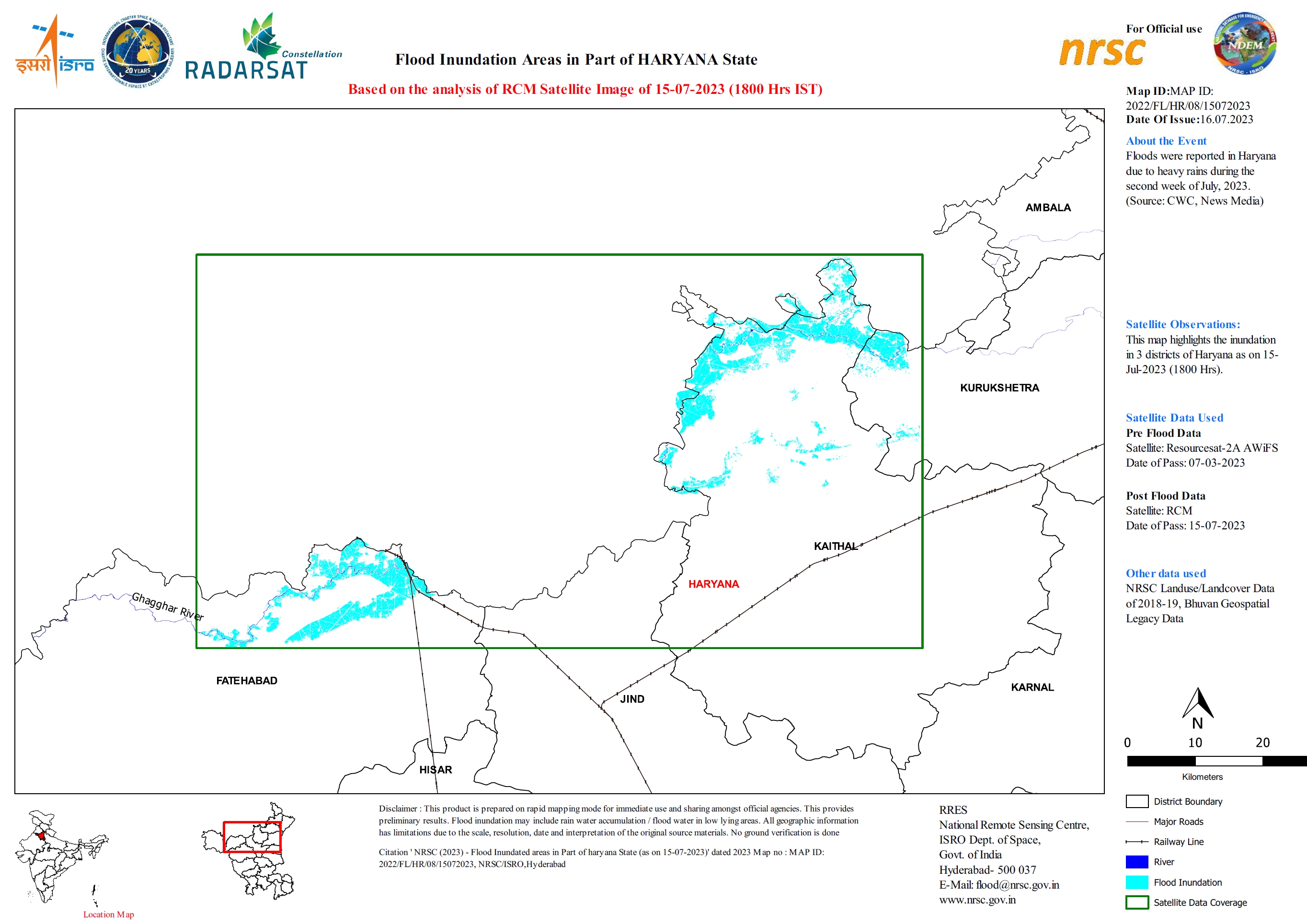
Flood Inundation Areas in Part of Haryana State
Direitos autorais: RADARSAT Constellation Mission Imagery © Government of Canada (2023) - RADARSAT is an official mark of the Canadian Space Agency
Map produced by National Remote Sensing Centre, ISRO
Information about the Product
Adquirida: 15/07/2023
Fonte: RCM
Categoria: Reference Map

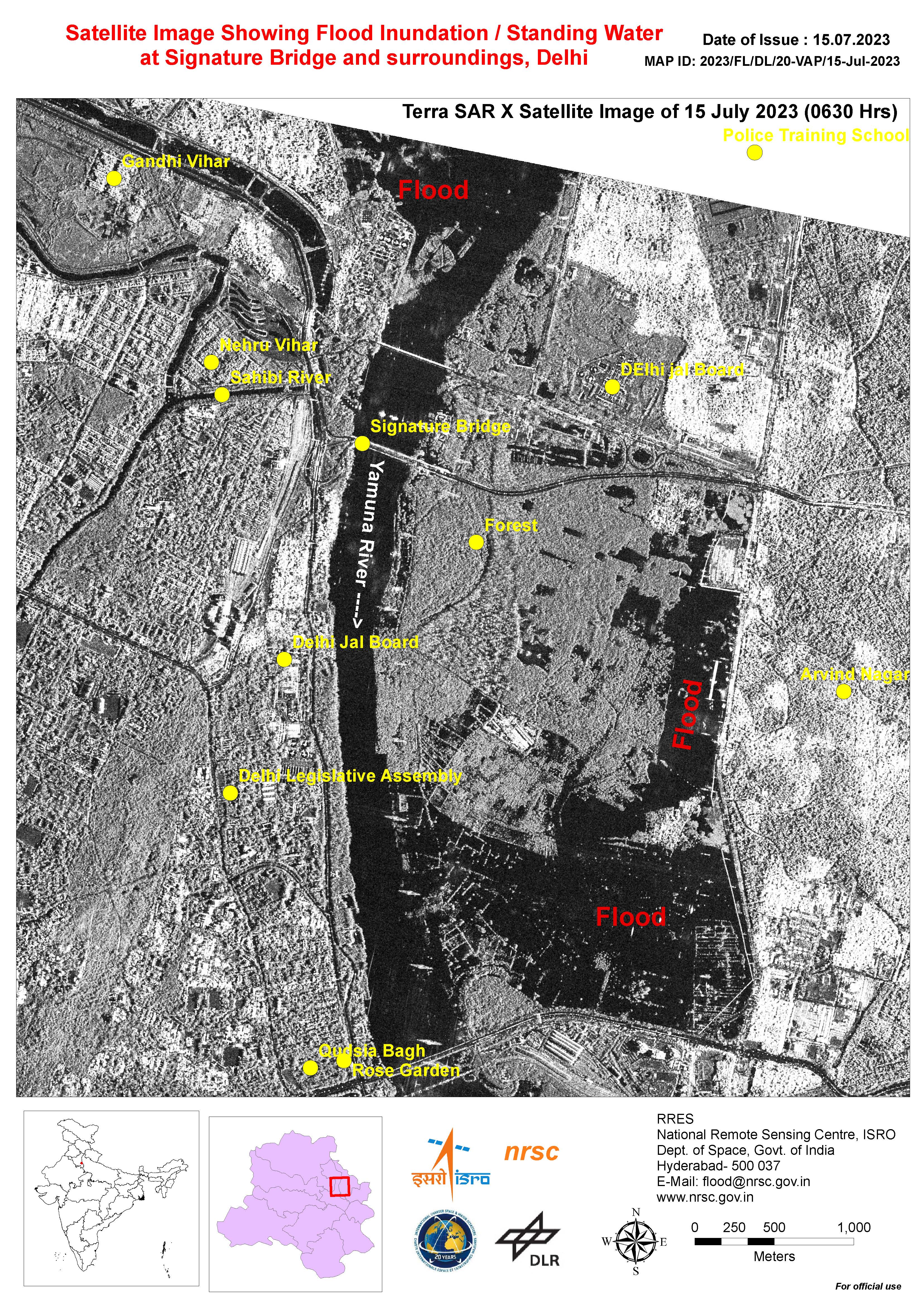
Satellite Image Showing Flood Inundation and Standing Water at the Signature Bridge and surroundings, Delhi
Direitos autorais: © DLR e.V. (2023), Distribution Airbus DS Geo GmbH
Map produced by National Remote Sensing Centre, ISRO.
Information about the Product
Adquirida: 15/07/2023
Fonte: TerraSAR-X
Categoria: Reference Map
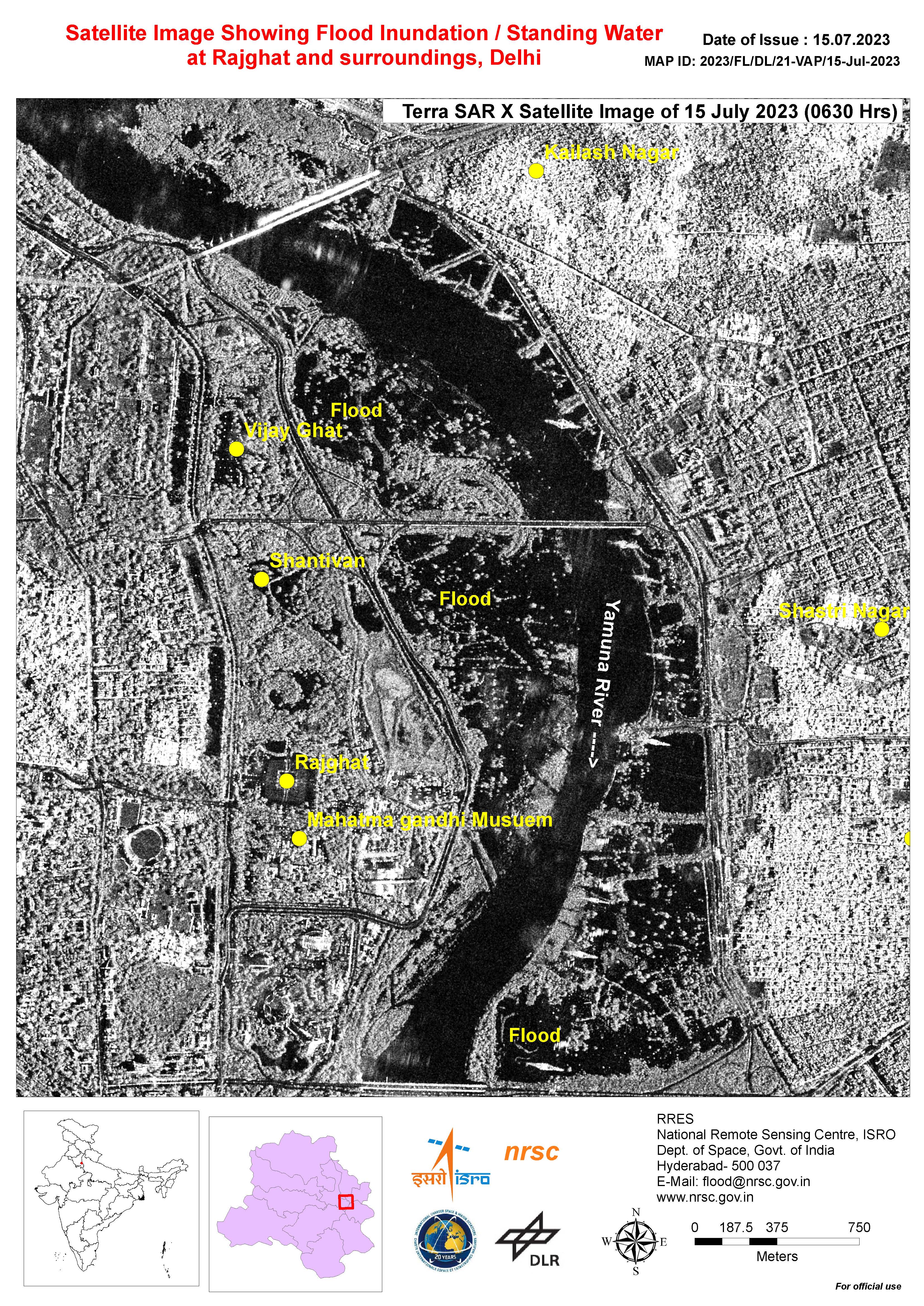
Satellite Image Showing Flood Inundation and Standing Water in Rajghat and surroundings, Delhi
Direitos autorais: © DLR e.V. (2023), Distribution Airbus DS Geo GmbH
Map produced by National Remote Sensing Centre, ISRO.
Information about the Product
Adquirida: 15/07/2023
Fonte: TerraSAR-X
Categoria: Reference Map
 Voltar ao arquivo completo da Ativação

