 English
 Spanish
 French
 Chinese
 Russian
 Portuguese
 Latest Activation
Charter activations
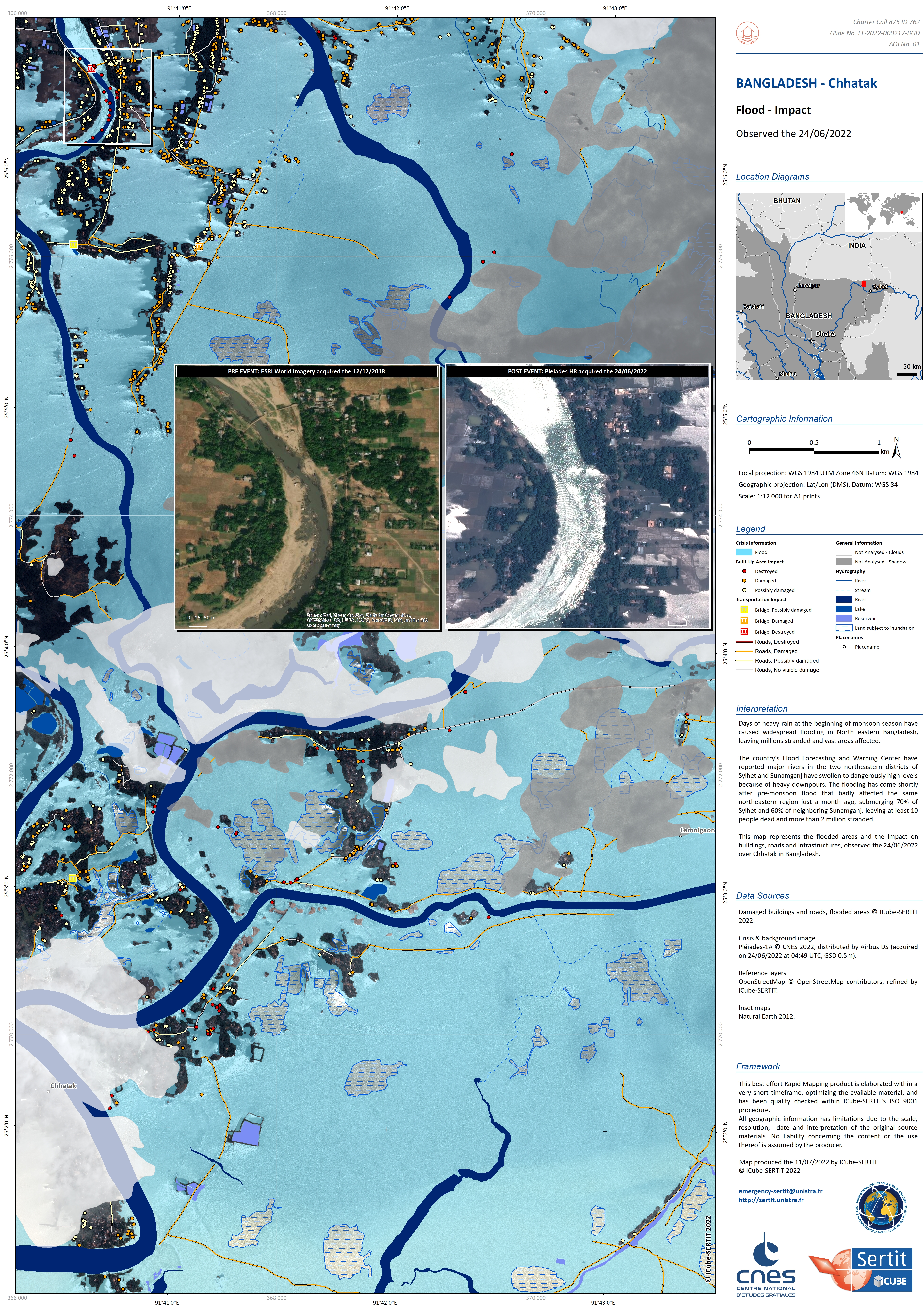
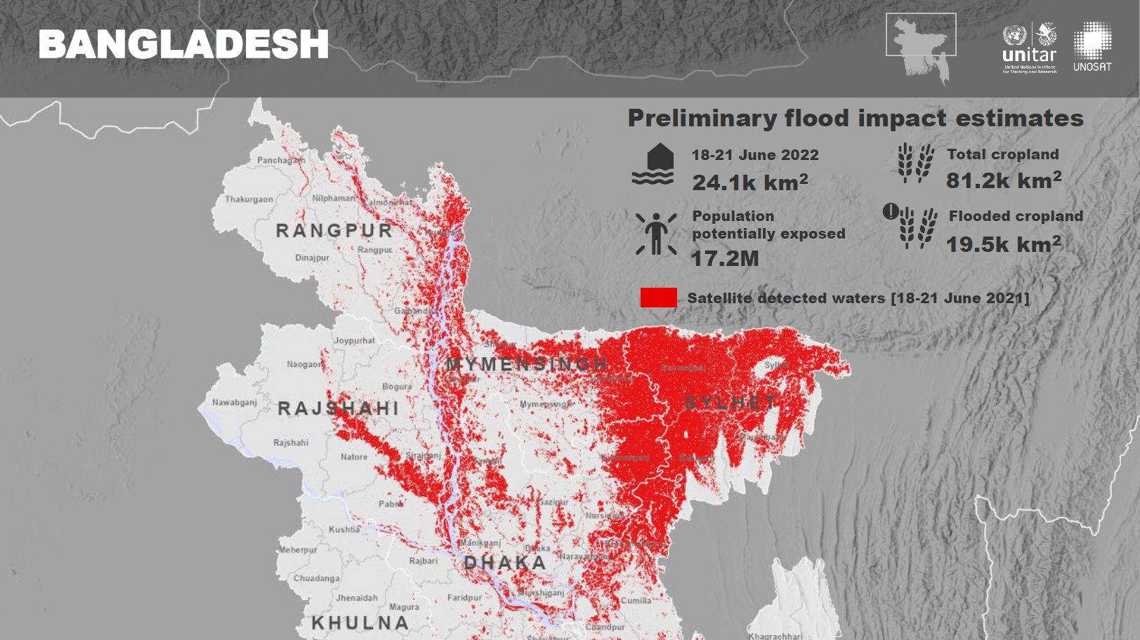
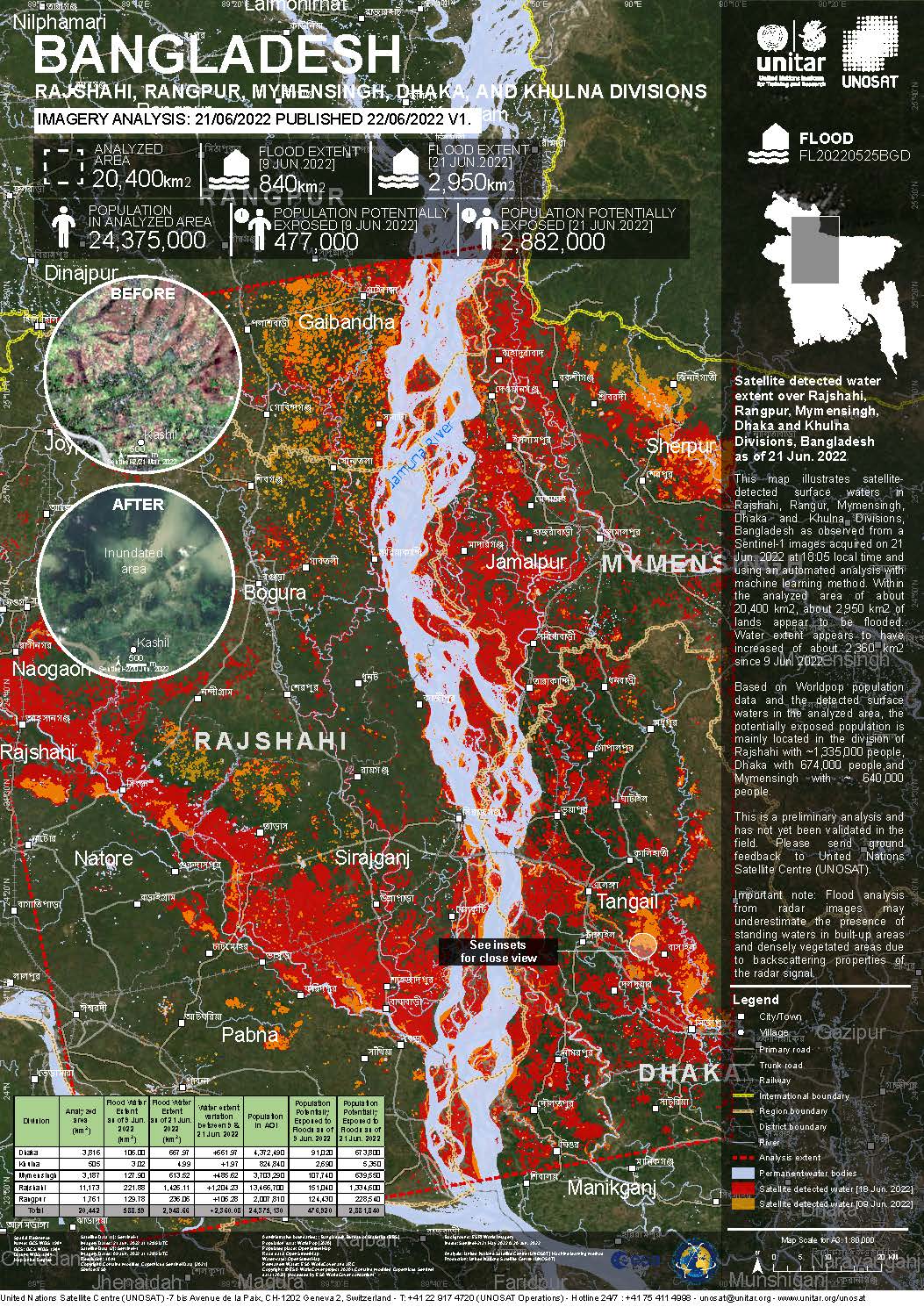
Flooding in Bangladesh
Days of heavy rain at the beginning of monsoon season caused widespread flooding in North Eastern Bangladesh, leaving millions stranded and vast areas affected.
The country's Flood Forecasting and Warning Center reported major rivers in the two northeastern districts of Sylhet and Sunamganj to be swollen to dangerously high levels because of heavy downpours.
The government deployed members of the armed forces across the region to speed up flood rescue and relief efforts. The flooding came shortly after a pre-monsoon flood that badly affected the same northeastern region just a month previously, submerging 70% of Sylhet and 60% of neighboring Sunamganj, leaving at least 10 people dead and more than 2 million stranded.
| Local do evento: | Bangladesh |
| Data da Ativação da Carta: | 2022-06-17 |
| Tempo de Ativação da Carta: | 21:49 |
| Zona de Tempo da Ativação da Carta: | UTC+02:00 |
| Requisitante da Carta: | UNITAR on behalf of United Nations Office for the Coordination of Humanitarian Affairs (OCHA) | Regional Office for Asia and the Pacific |
| ID da Ativação: | 762 |
| Gerenciamento de projeto: | UNITAR |
Products

Preliminary satellite-derived flood assessment as of 15-22 July 2022 in Bangladesh
Download Full Report
Direitos autorais: Contains modified Copernicus Sentinel data (2022)
Maps produced by United Nations Satellite Centre (UNOSAT)
Information about the Product
Adquirida: 20/07/2022, 15/07/2022 and 22/08/2022
Fonte: Sentinel-1
Categoria: Dossier
Preliminary satellite derived flood assessment in Bangladesh
Download full report
Direitos autorais: Contains modified Copernicus Sentinel data (2022)
Map prepared by UNITAR / UNOSAT
Information about the Product
Adquirida: 18/06/2022 and 21/06/2022
Fonte: Sentinel-1
Categoria: Dossier
Satellite detected water extent and impact over Sylhet and Sunamganj Districts, Sylhet Division of Bangladesh
Direitos autorais: RADARSAT Constellation Mission Imagery © Government of Canada (2022) - RADARSAT is an official mark of the Canadian Space Agency
Map produced by UNITAR / UNOSAT
Information about the Product
Adquirida: 18/06/2022
Fonte: RCM
Categoria: Reference Map
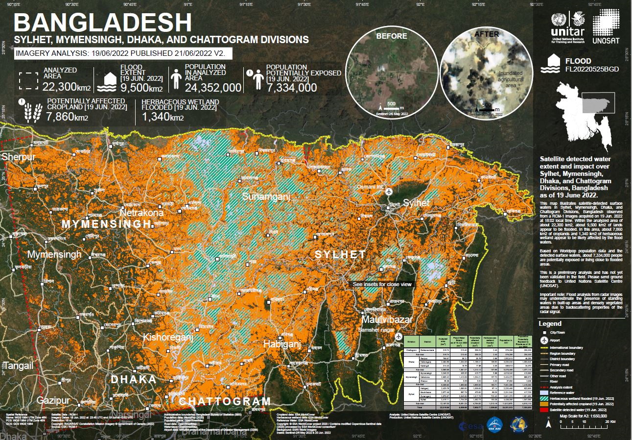
Satellite detected water extent and impact over Sylhet, Mymensingh, Dhaka, and Chattogram Divisions of Bangladesh
Direitos autorais: RADARSAT Constellation Mission Imagery © Government of Canada (2022) - RADARSAT is an official mark of the Canadian Space Agency
Map produced by UNITAR / UNOSAT
Information about the Product
Adquirida: 18/06/2022 and 19/06/2022
Fonte: RCM
Categoria: Grading Map
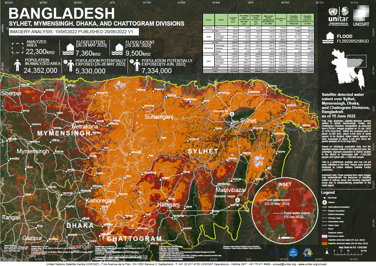
Satellite detected water extent over Sylhet, Mymensingh, Dhaka, and Chattogram Divisions, Bangladesh
Direitos autorais: RADARSAT Constellation Mission Imagery © Government of Canada (2022) - RADARSAT is an official mark of the Canadian Space Agency
Map produced by UNITAR / UNOSAT
Information about the Product
Adquirida: 18/06/2022 and 19/06/2022
Fonte: RCM
Categoria: Delineation Map
 Voltar ao arquivo completo da Ativação

