 English
 Spanish
 French
 Chinese
 Russian
 Portuguese
 Latest Activation
Charter activations
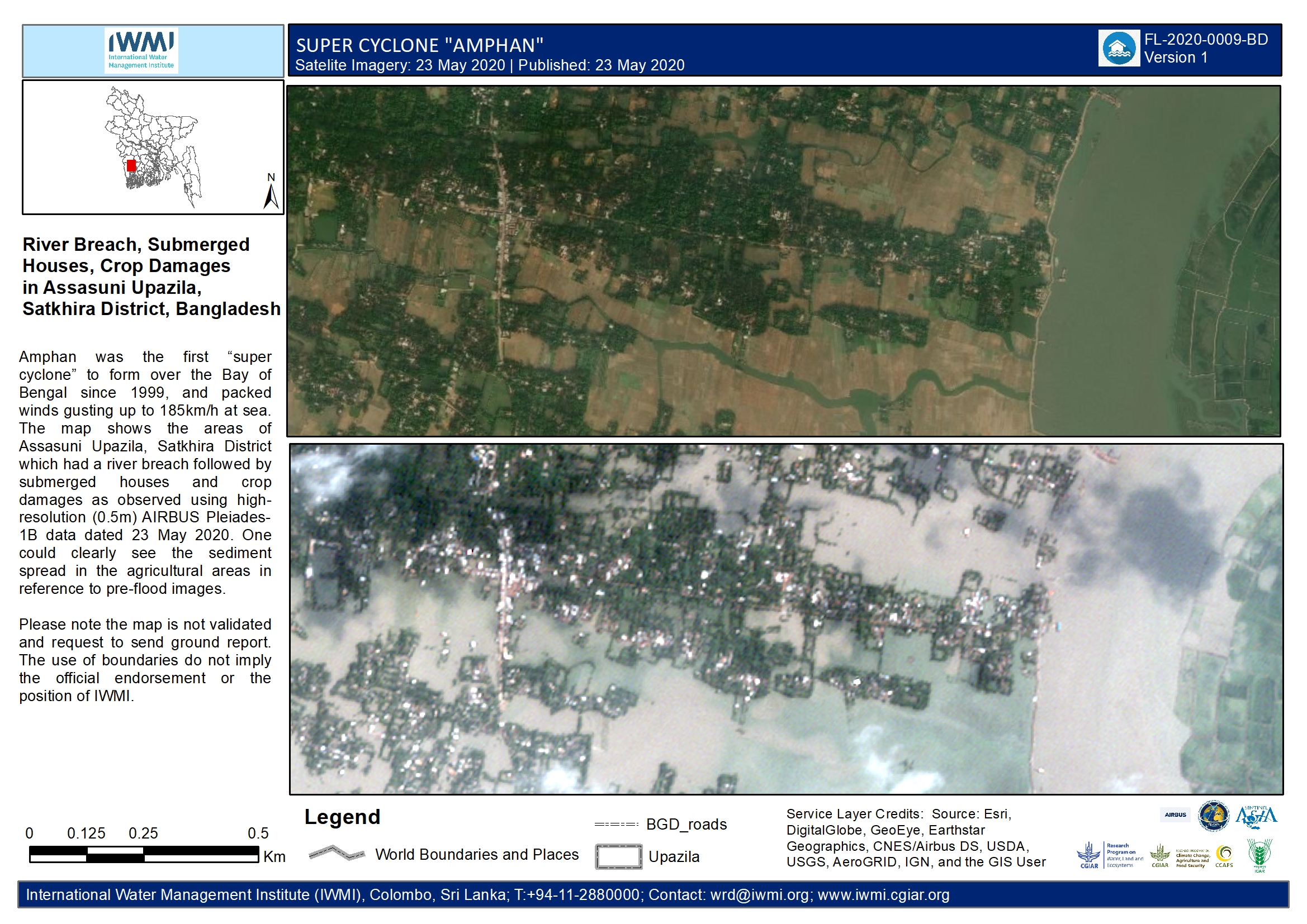
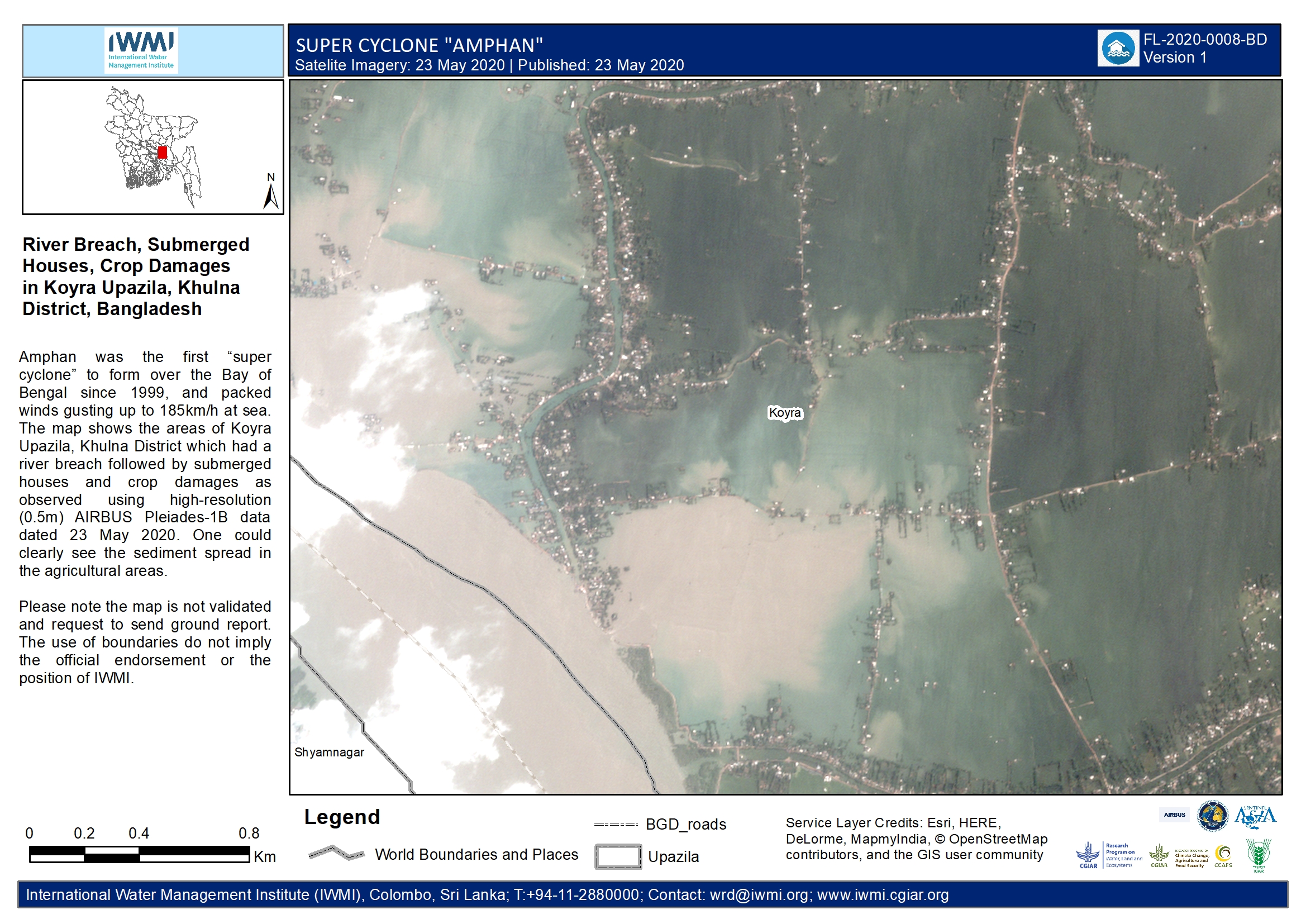
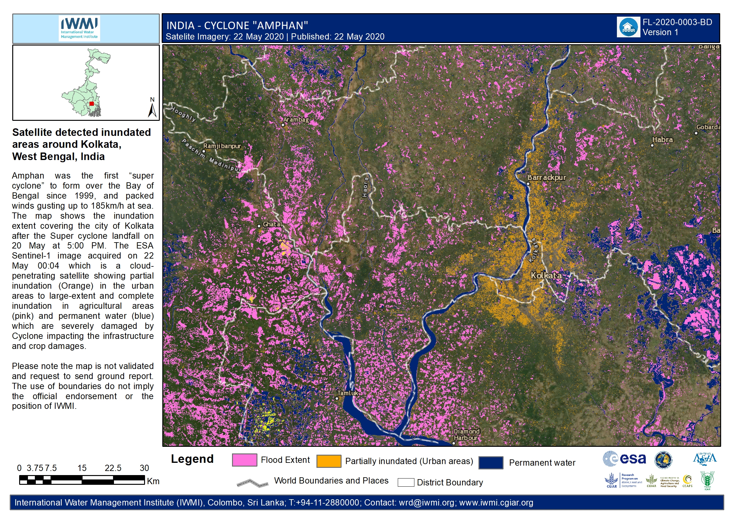
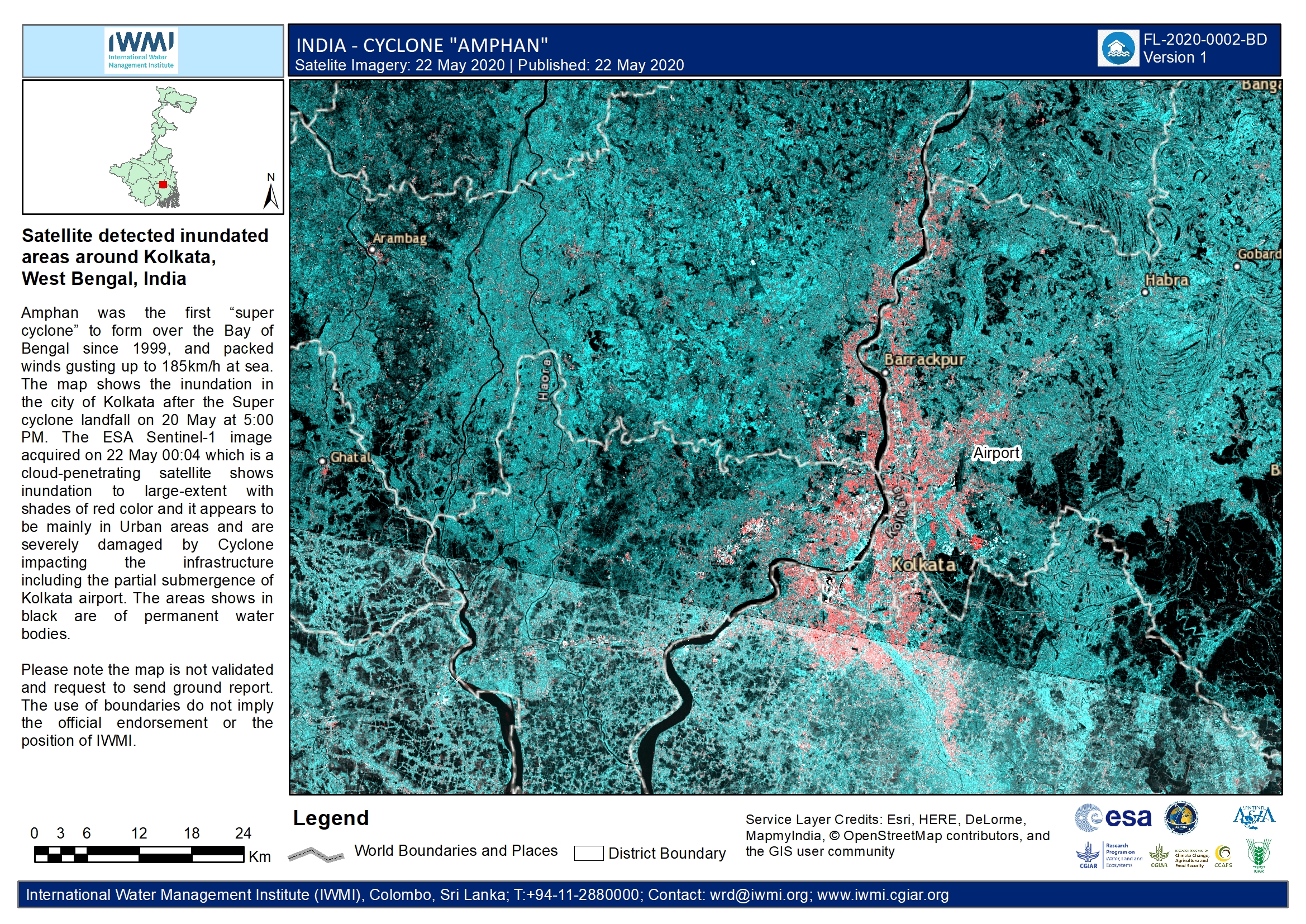
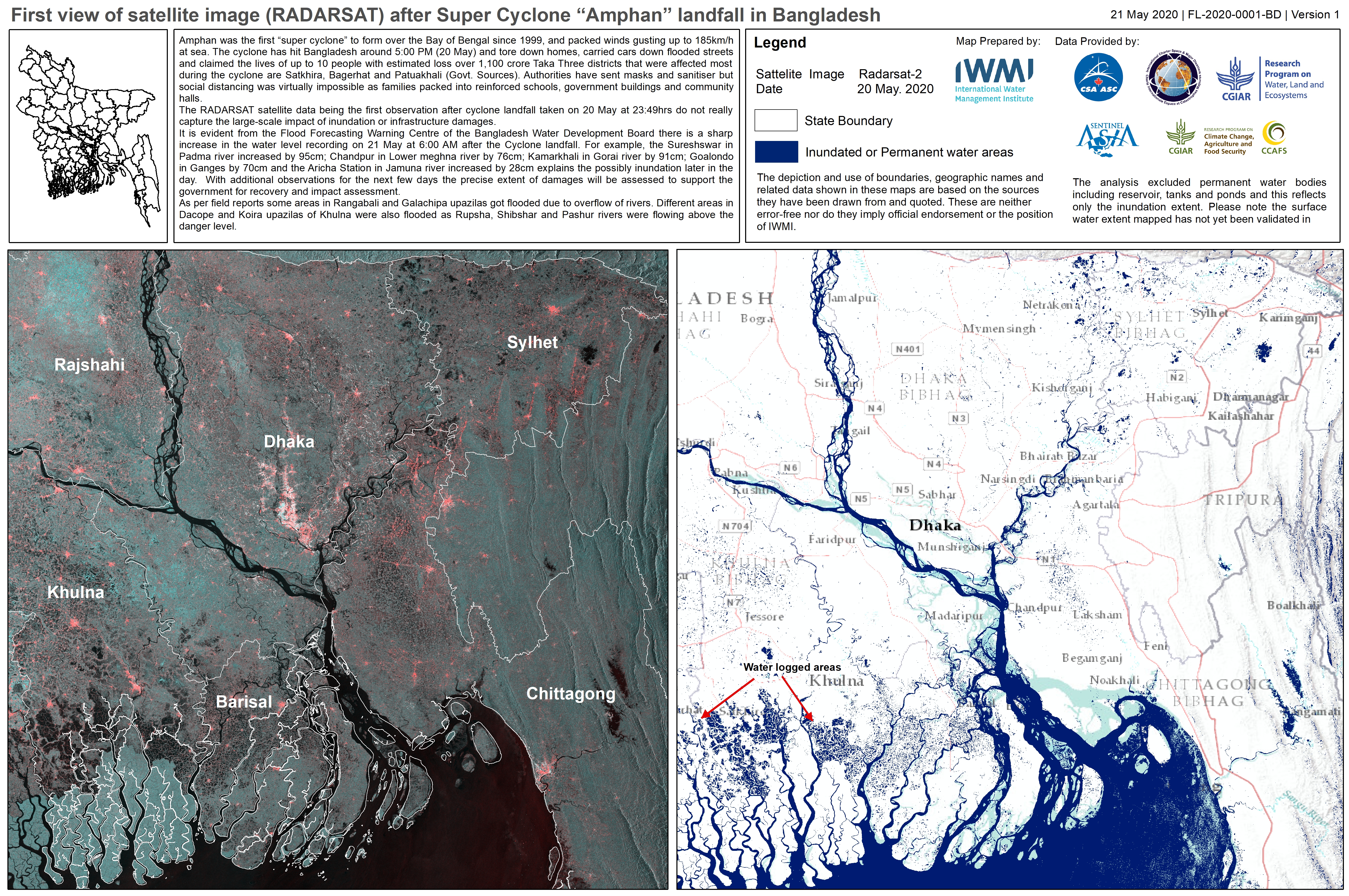
Cyclone Amphan in Bangladesh
Cyclone Amphan is expected to make landfall in Bangladesh on 20 May, on the coasts of India and Bangladesh between the Sagar Islands in West Bengal and the Hatiya Islands in Bangladesh.
The storm is currently Category Four on the Saffir-Simpson scale, but when it entered the Bay of Bengal on 18 May it was the strongest storm on record in the area and classified as a Super Cyclone. The storm had wind speeds of 270 kilometres per hour, but has since weakened to 200 kilometres per hour. The strong winds are expected to cause damage and the storm is forecast to bring heavy rain causing flooding.
Two million people have been evacuated in the area and are being placed in emergency shelters. The Coronavirus is complicating evacuations and emergency care, however, and the evacuees are expected to wear masks and gloves. To try to maintain distance between the evacuees, more than 12,000 shelters have been set up.
Related News and Resources
| Tipo de evento: | Ocean Storm - Cyclone |
| Local do evento: | Bangladesh |
| Data da Ativação da Carta: | 2020-05-18 |
| Tempo de Ativação da Carta: | 18:59 |
| Zona de Tempo da Ativação da Carta: | UTC+09:00 |
| Requisitante da Carta: | ADRC UNITAR on behalf of United Nations Office for the Coordination of Humanitarian Affairs (OCHA) |
| ID da Ativação: | 652 |
| Gerenciamento de projeto: | International Water Management Institute |
Products
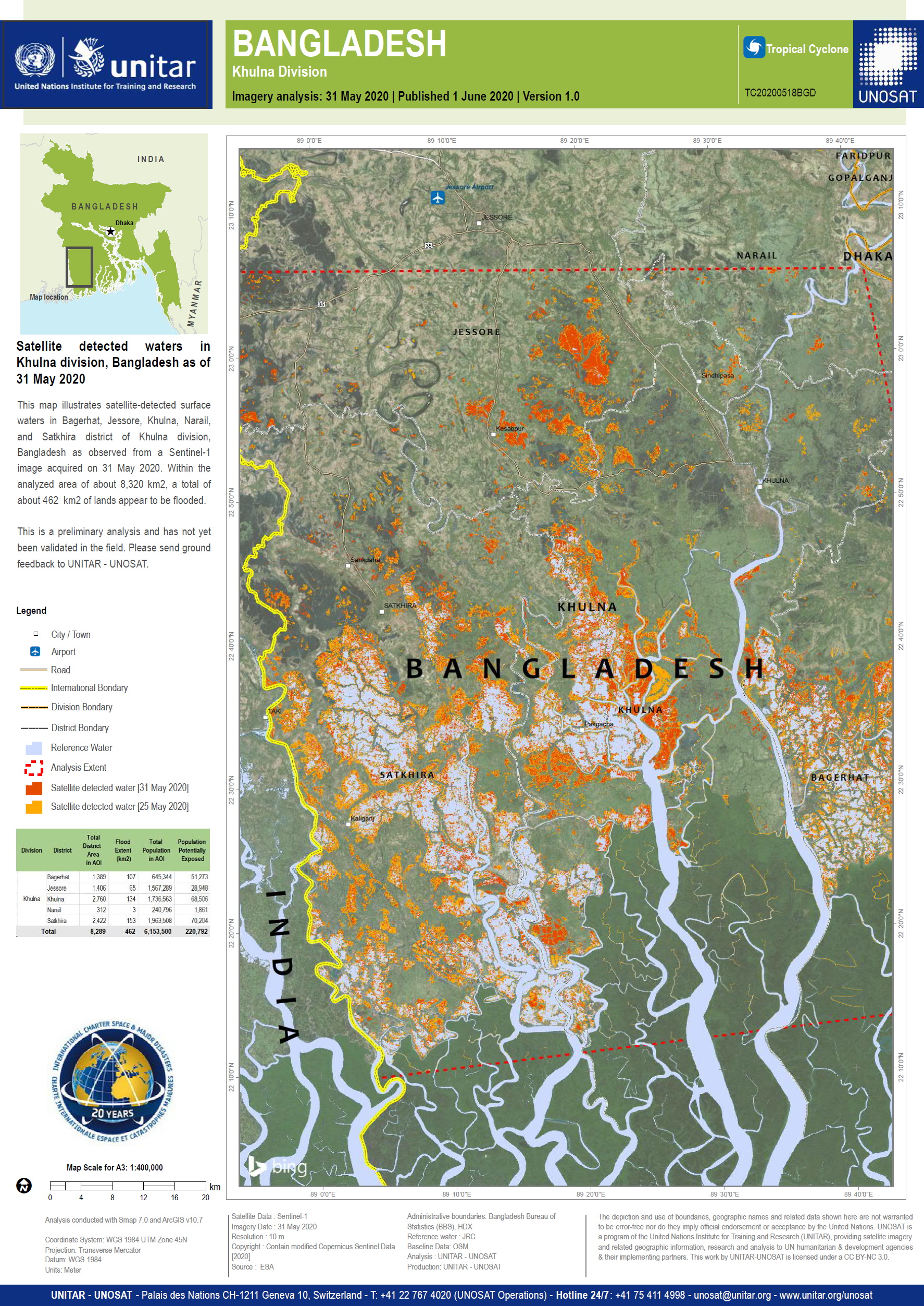
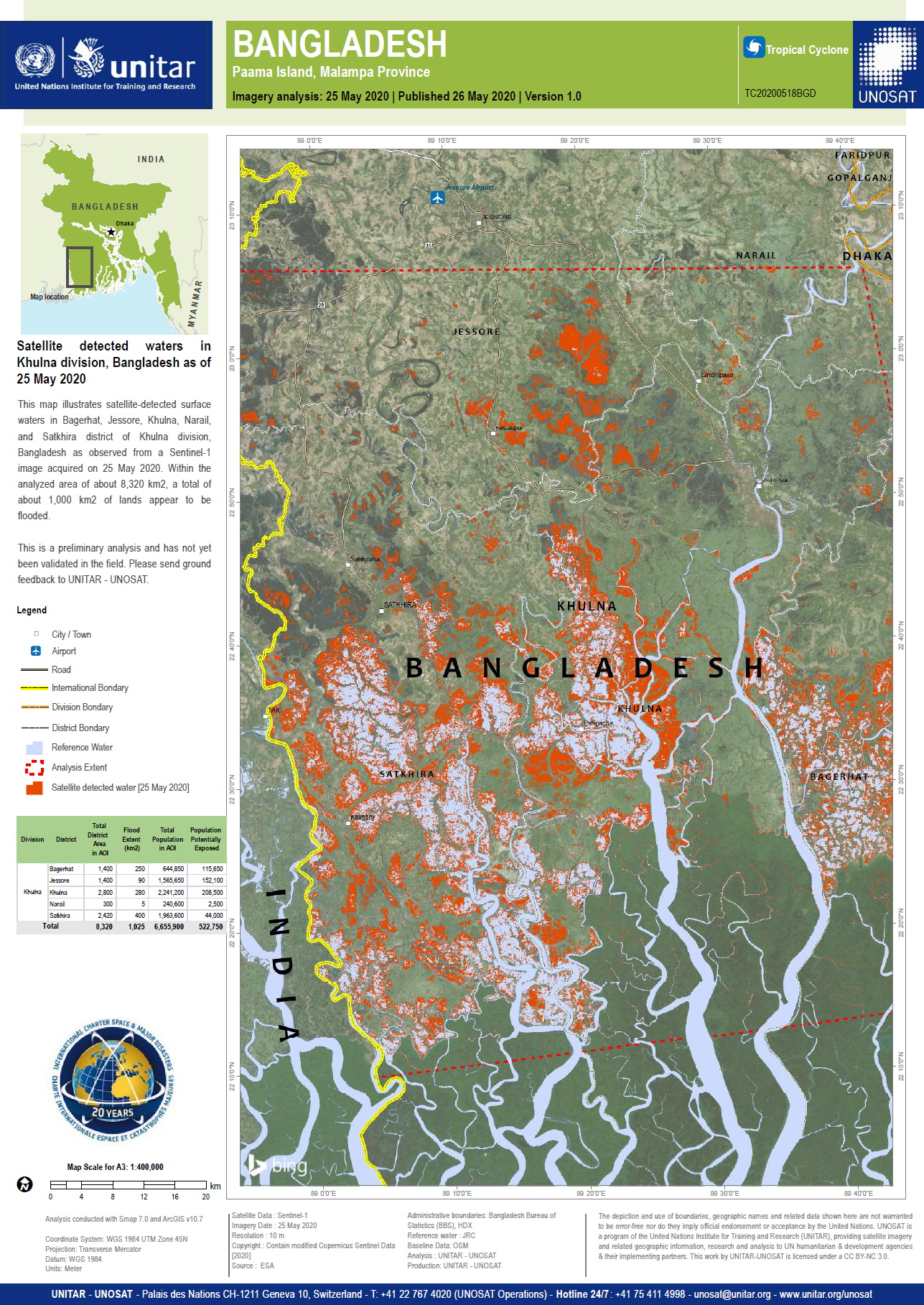
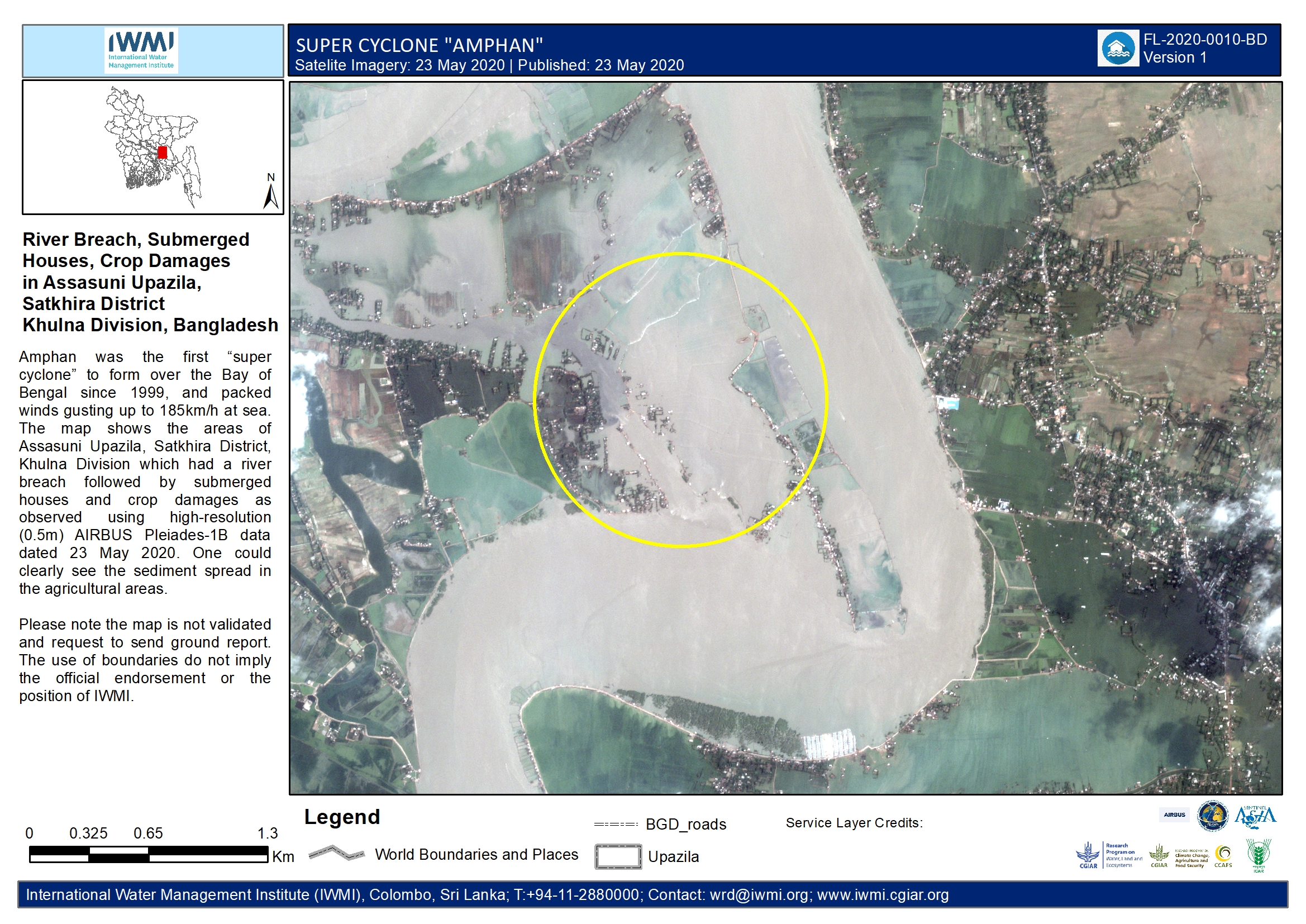
Preliminary satellite-derived flood assessment report in Jessore, Satkhira and Khulna District, Bangladesh
Download the full report
Direitos autorais: Includes Pleiades material © CNES (2020), Distribution Airbus DS
Google Earth
Report produced by UNITAR / UNOSAT
Information about the Product
Adquirida: 24/05/2020 and 25/05/2020
Fonte: Pleiades / Google Earth
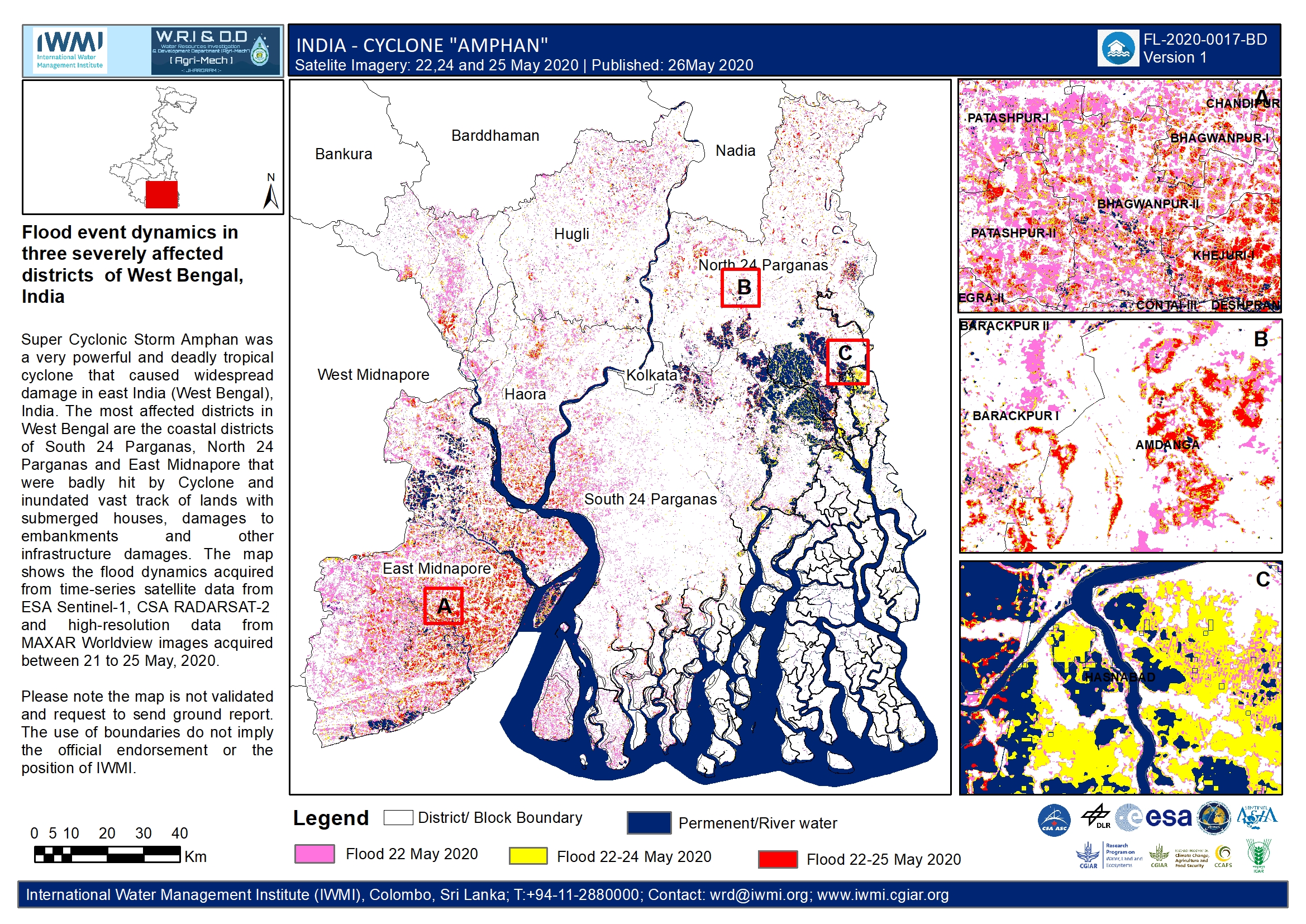
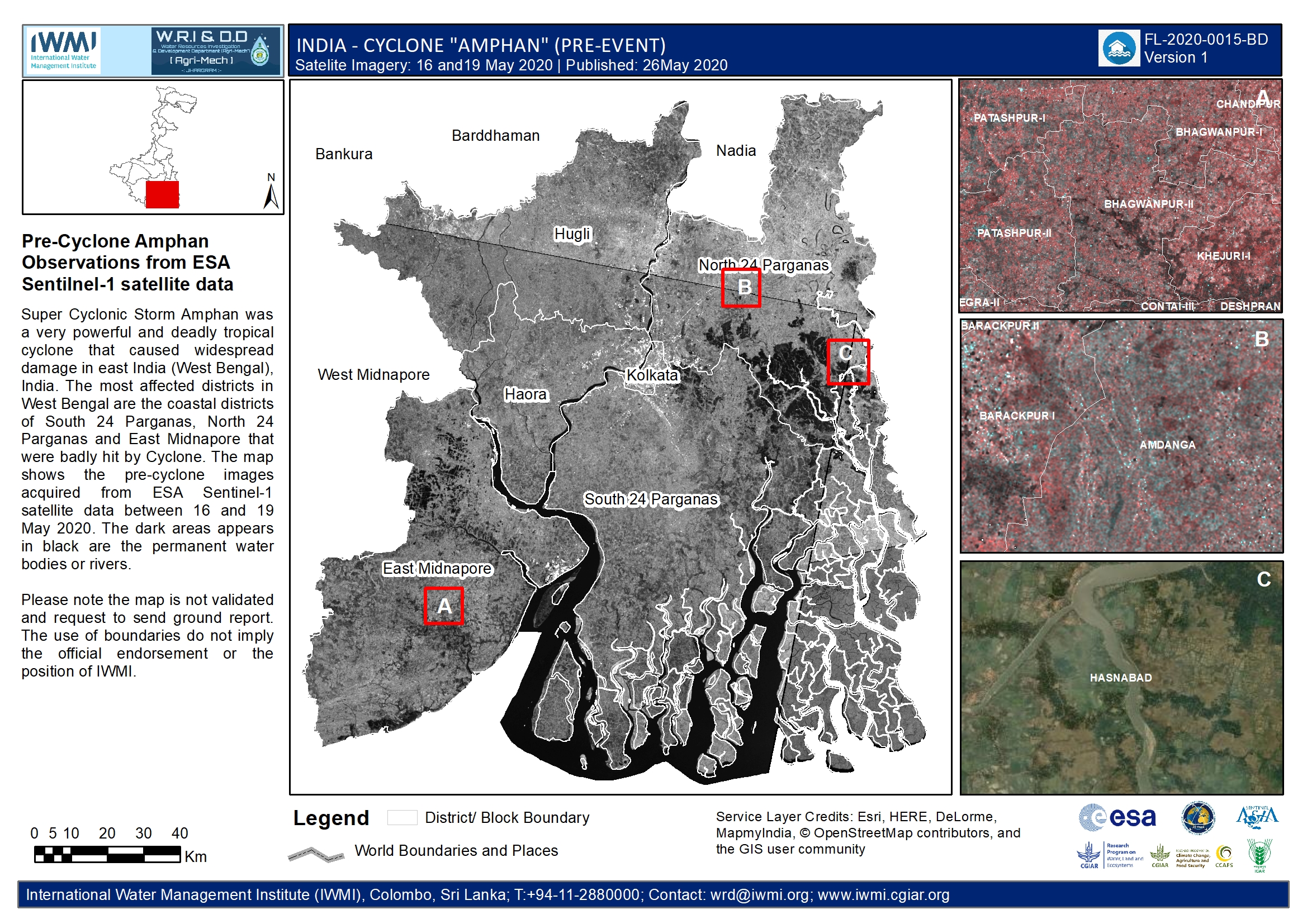
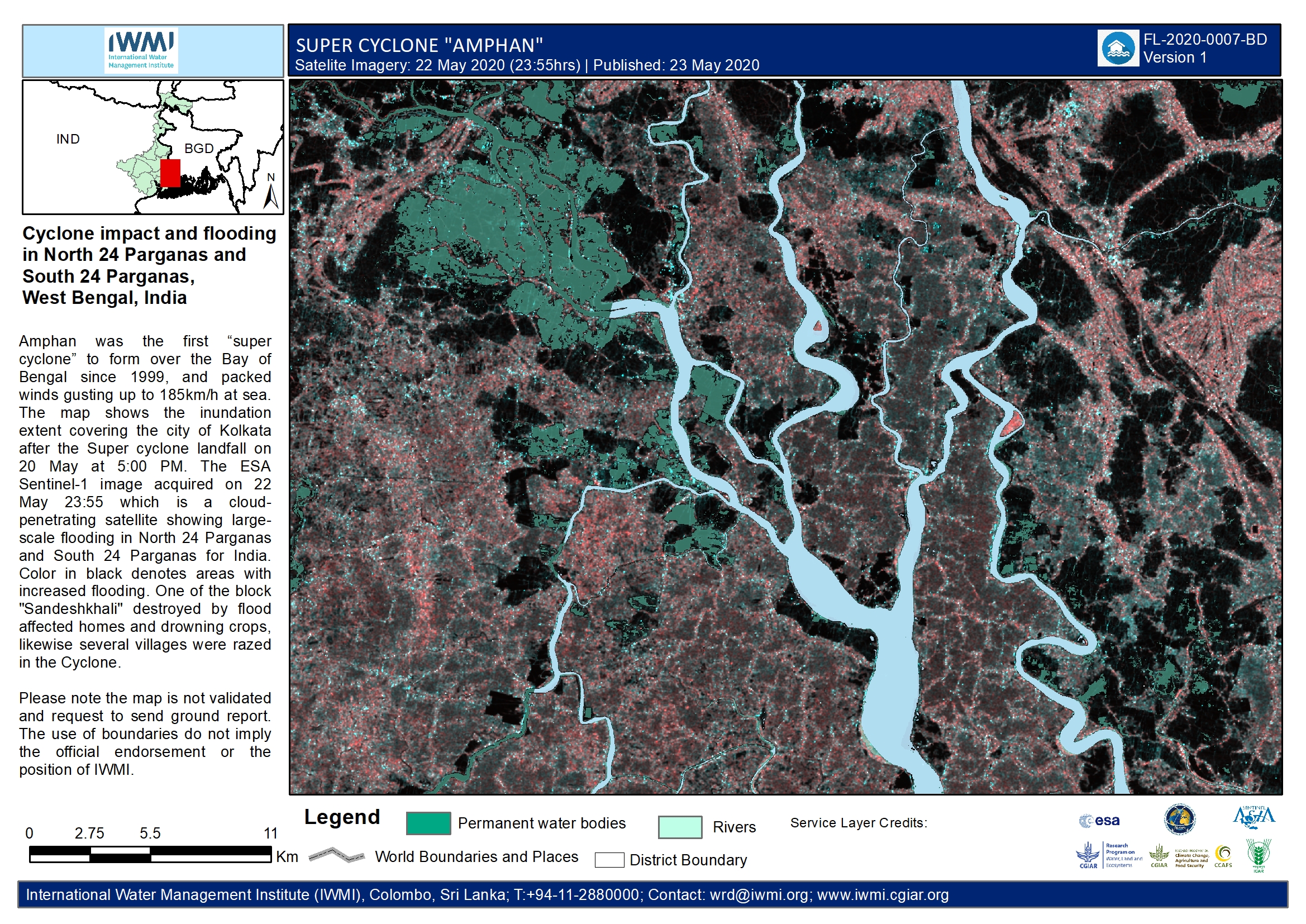
Flood event dynamics in three severely affected districts in West Bengal, India
Direitos autorais: RADARSAT-2 Data and Products © Maxar Technologies Ltd. (2020) - All Rights Reserved. RADARSAT is an official trademark of the Canadian Space Agency.
TerraSAR-X © DLR e.V. (2020), Distribution Airbus DS Geo GmbH
Contains modified Copernicus Sentinel data (2020)
Map produced by IWMI
Information about the Product
Adquirida: RADARSAT-2: 22/05/2020
TerraSAR-X: 24/05/2020
Sentinel-1: 22/05/2020 and 25/05/2020
Fonte: RADARSAT-2 / TerraSAR-X / Sentinel-1
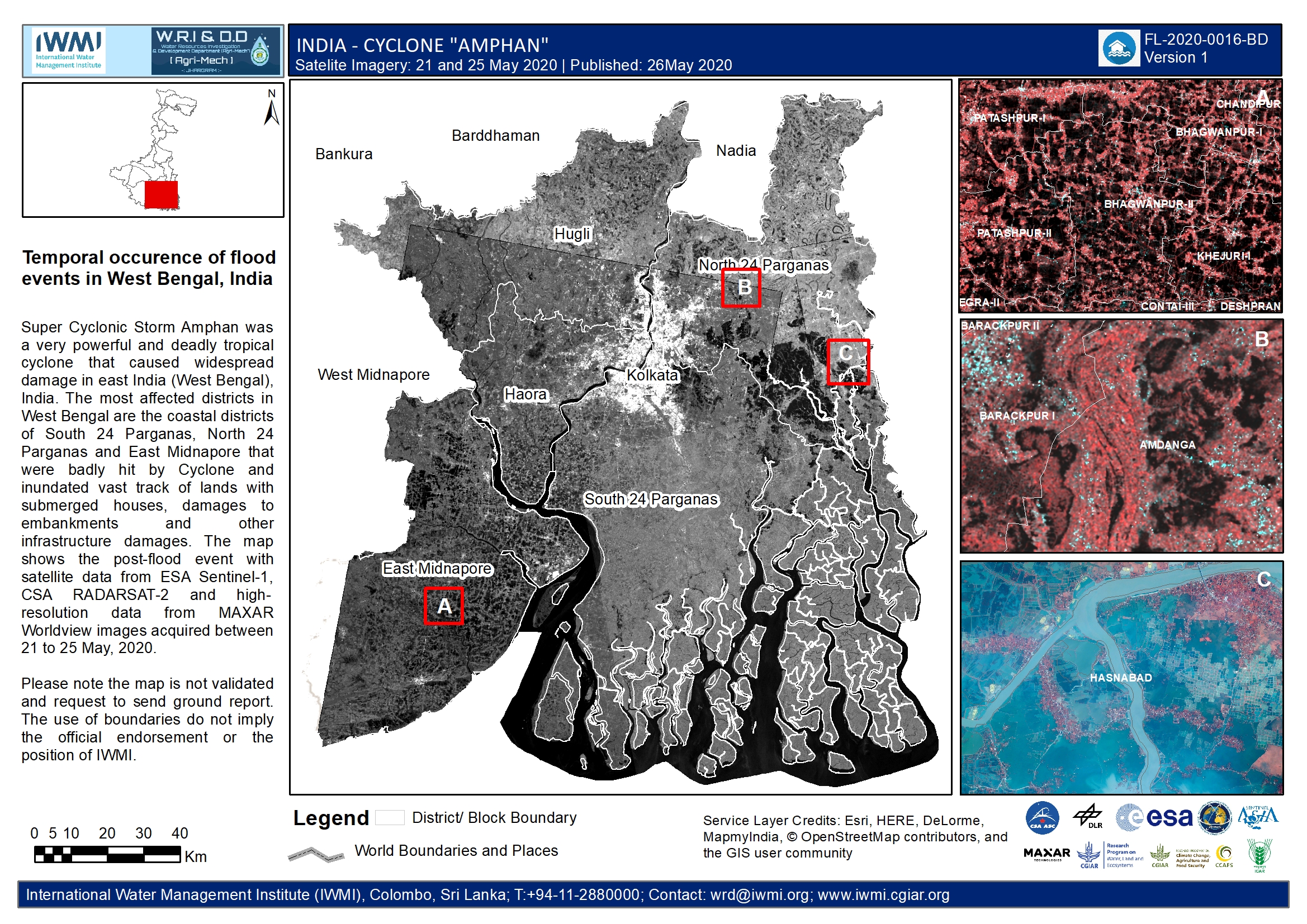
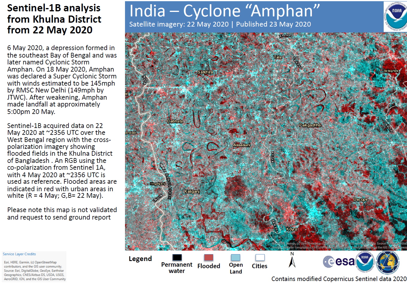
Temporal flood occurrence of critically affected districts in West Bengal, India
Direitos autorais: Contains modified Copernicus Sentinel data (2020)
WorldView-2 © (2020) DigitalGlobe, Inc., Longmont CO USA 80503. DigitalGlobe and the DigitalGlobe logos are trademarks of DigitalGlobe, Inc. The use and/or dissemination of this data and/or of any product in any way derived there from are restricted. Unauthorized use and/or dissemination is prohibited
RADARSAT-2 Data and Products © Maxar Technologies Ltd. (2020) - All Rights Reserved. RADARSAT is an official trademark of the Canadian Space Agency.
TerraSAR-X © DLR e.V. (2020), Distribution Airbus DS Geo GmbH
Map produced by IWMI
Information about the Product
Adquirida: Sentinel-1: 22/05/2020 and 25/05/2020
WorldView-2: 22/05/2020
RADARSAT-2: 22/05/2020
TerraSAR-X: 22/05/2020
Fonte: Sentinel-1 / WorldView-2 / RADARSAT-2 / TerraSAR-X
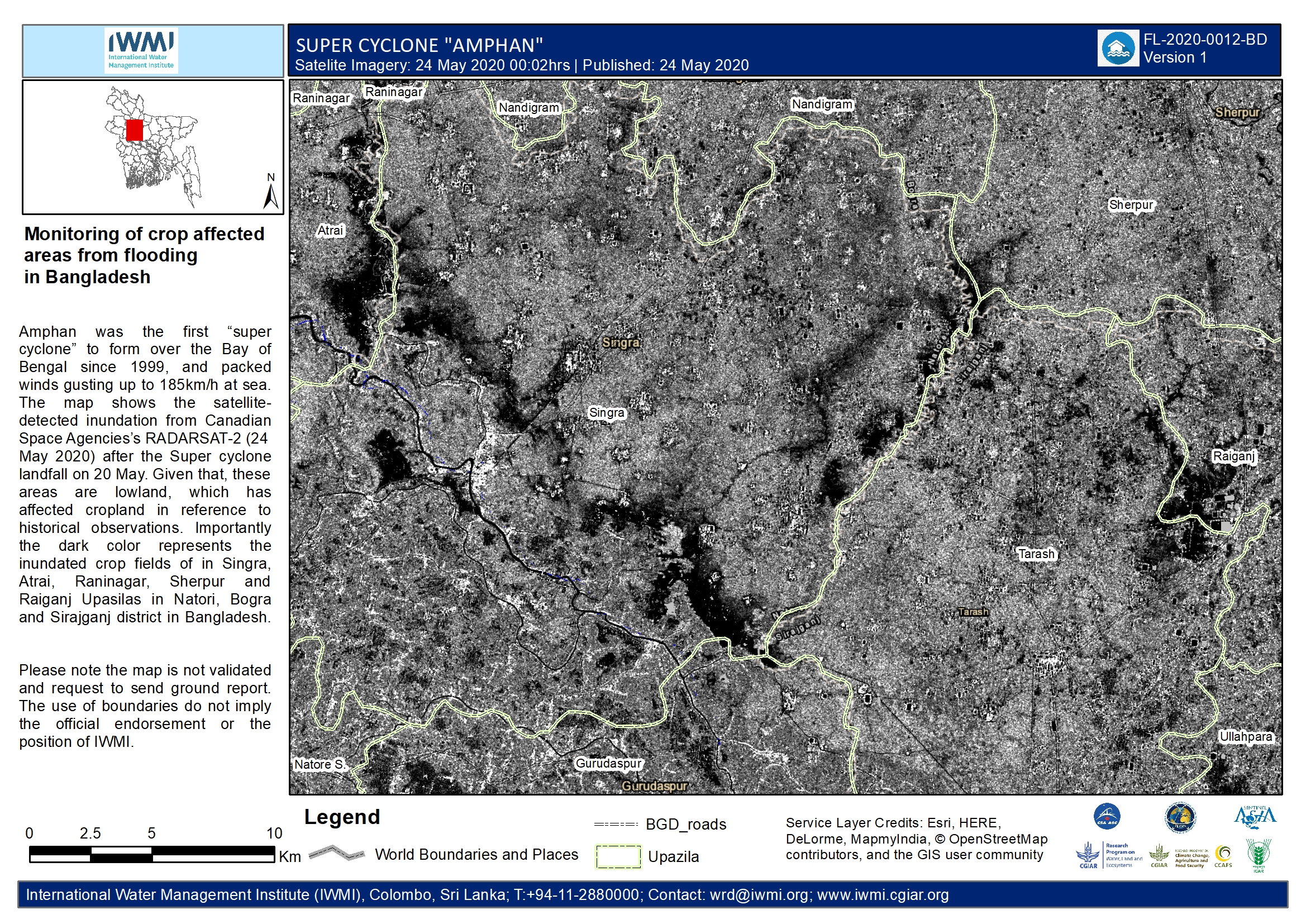
Monitoring of crop-affected areas from flooding in Bangladesh
Direitos autorais: RADARSAT-2 Data and Products © Maxar Technologies Ltd. (2020) – All Rights Reserved
RADARSAT is an official mark of the Canadian Space Agency
Map produced by IWMI
Information about the Product
Adquirida: 24/05/2020
Fonte: RADARSAT-2
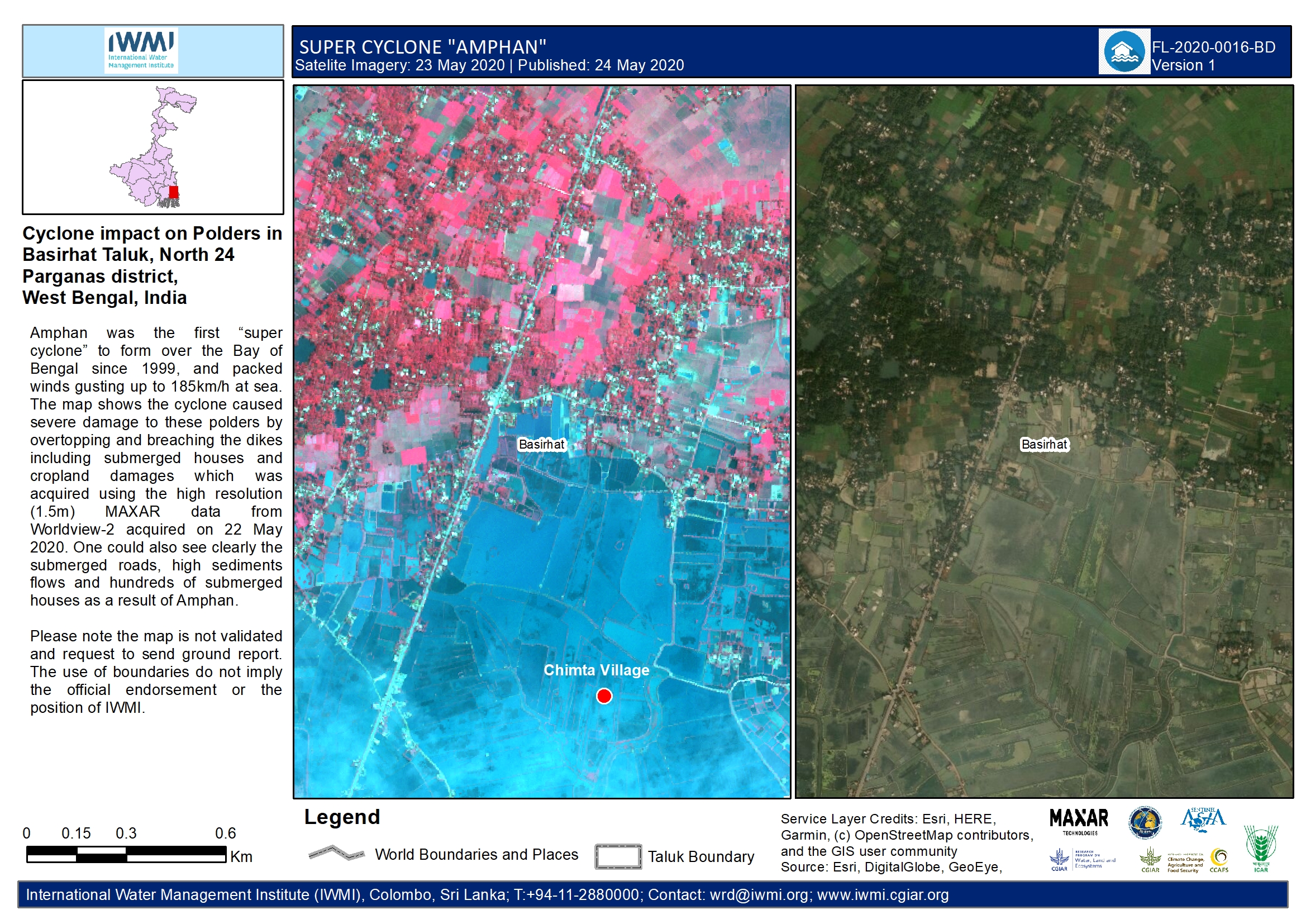
Cyclone impact of Polders in Basirhat Taluk, North 24 Parganas district, West Bengal, India
Direitos autorais: © (2020) DigitalGlobe, Inc., Longmont CO USA 80503. DigitalGlobe and the DigitalGlobe logos are trademarks of DigitalGlobe, Inc. The use and/or dissemination of this data and/or of any product in any way derived there from are restricted. Unauthorized use and/or dissemination is prohibited
Map produced by IWMI
Information about the Product
Adquirida: 22/05/2020
Fonte: WorldView-2
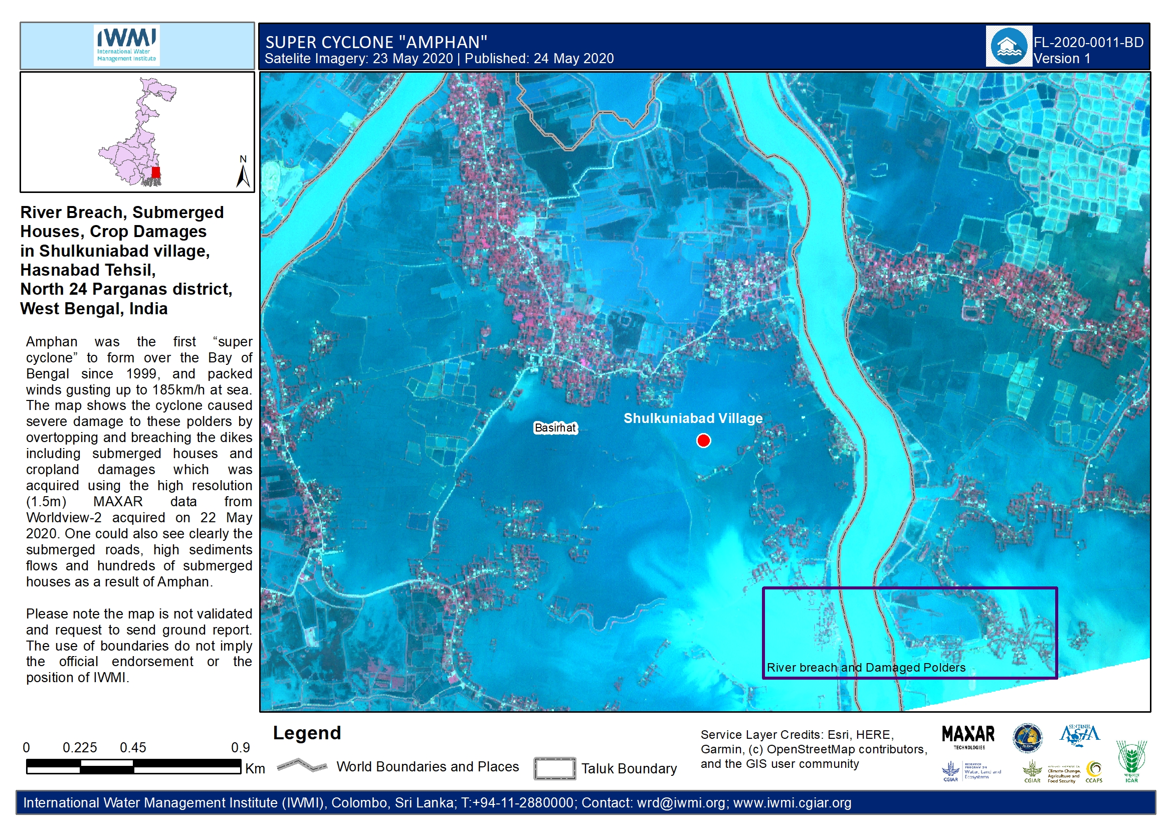
River breach, Submerged houses, crop damages in Shulkuniabad village, Hasnabad Tehsil, North 24 Parganas district, West Bengal, India
Direitos autorais: © (2020) DigitalGlobe, Inc., Longmont CO USA 80503. DigitalGlobe and the DigitalGlobe logos are trademarks of DigitalGlobe, Inc. The use and/or dissemination of this data and/or of any product in any way derived there from are restricted. Unauthorized use and/or dissemination is prohibited
Map produced by IWMI
Information about the Product
Adquirida: 22/05/2020
Fonte: WorldView-2
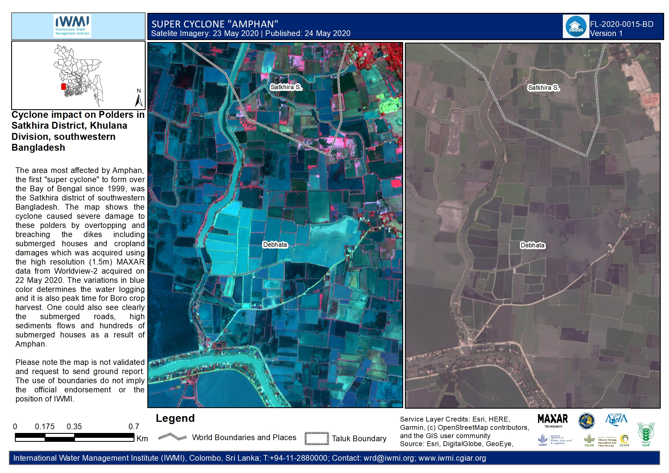
Cyclone impact on Polders in Satkhira District, Khulna Division, southwestern Bangladesh
Direitos autorais: © (2020) DigitalGlobe, Inc., Longmont CO USA 80503. DigitalGlobe and the DigitalGlobe logos are trademarks of DigitalGlobe, Inc. The use and/or dissemination of this data and/or of any product in any way derived there from are restricted. Unauthorized use and/or dissemination is prohibited
Map produced by IWMI
Information about the Product
Adquirida: 22/05/2020
Fonte: WorldView-2

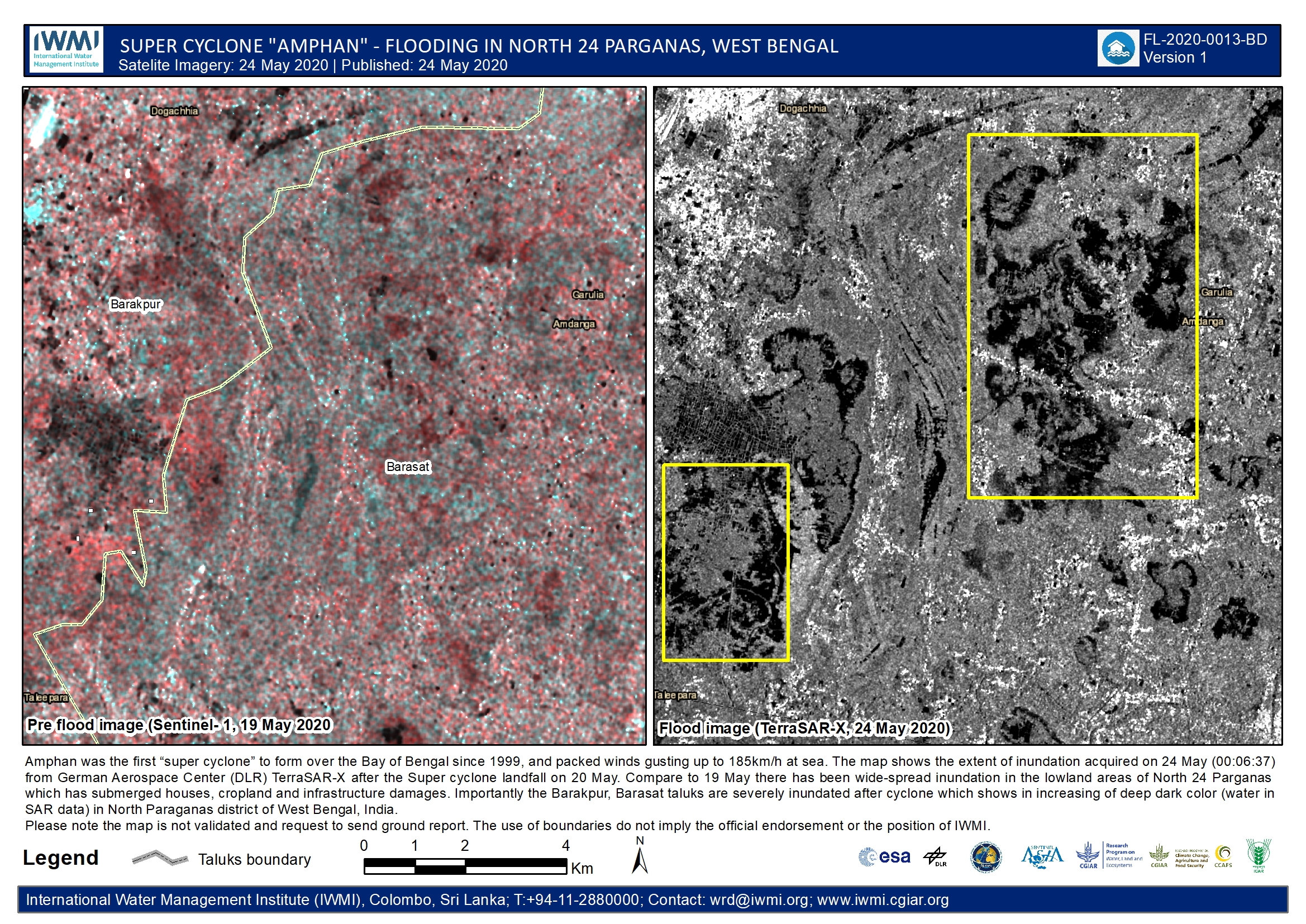
Flooding in Purba Medinipur District, West Bengal, India
Direitos autorais: TerraSAR-X © DLR e.V. (2020), Distribution Airbus DS Geo GmbH
Sentinel-1 Contains modified Copernicus Sentinel data (2020)
Map produced by IWMI
Information about the Product
Adquirida: TerraSAR-X: 24/05/2020
Sentinel-1: 19/05/2020
Fonte: TerraSAR-X / Sentinel-1
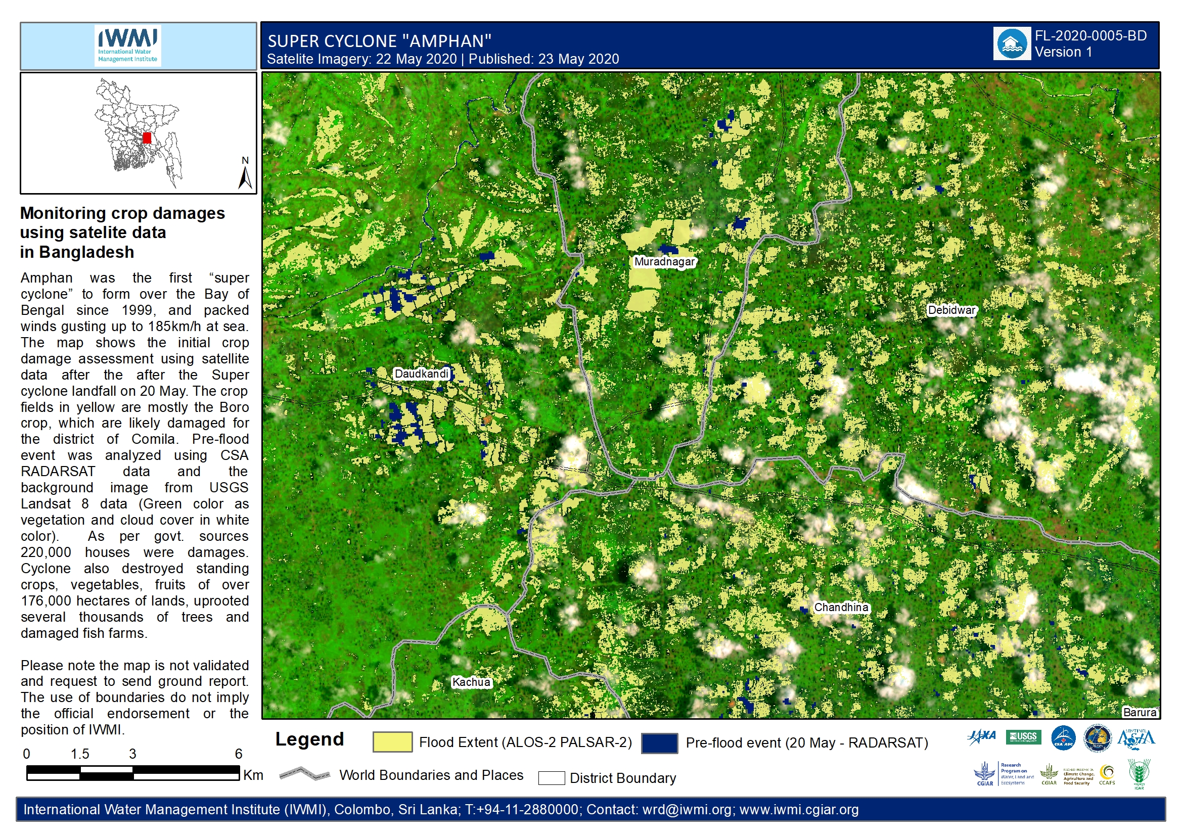
Post Cyclone Amphan Monitoring crop damages using satellite data in Bangladesh
Direitos autorais: © JAXA
© CSA
USGS / NASA Landsat Program
Map produced by IWMI
Information about the Product
Adquirida: Pre-event:
RADARSAT and Landsat 8: 20/05/2020
Post-event:
ALOS-2: 22/05/2020
Fonte: ALOS-2 / Landsat 8 / RADARSAT

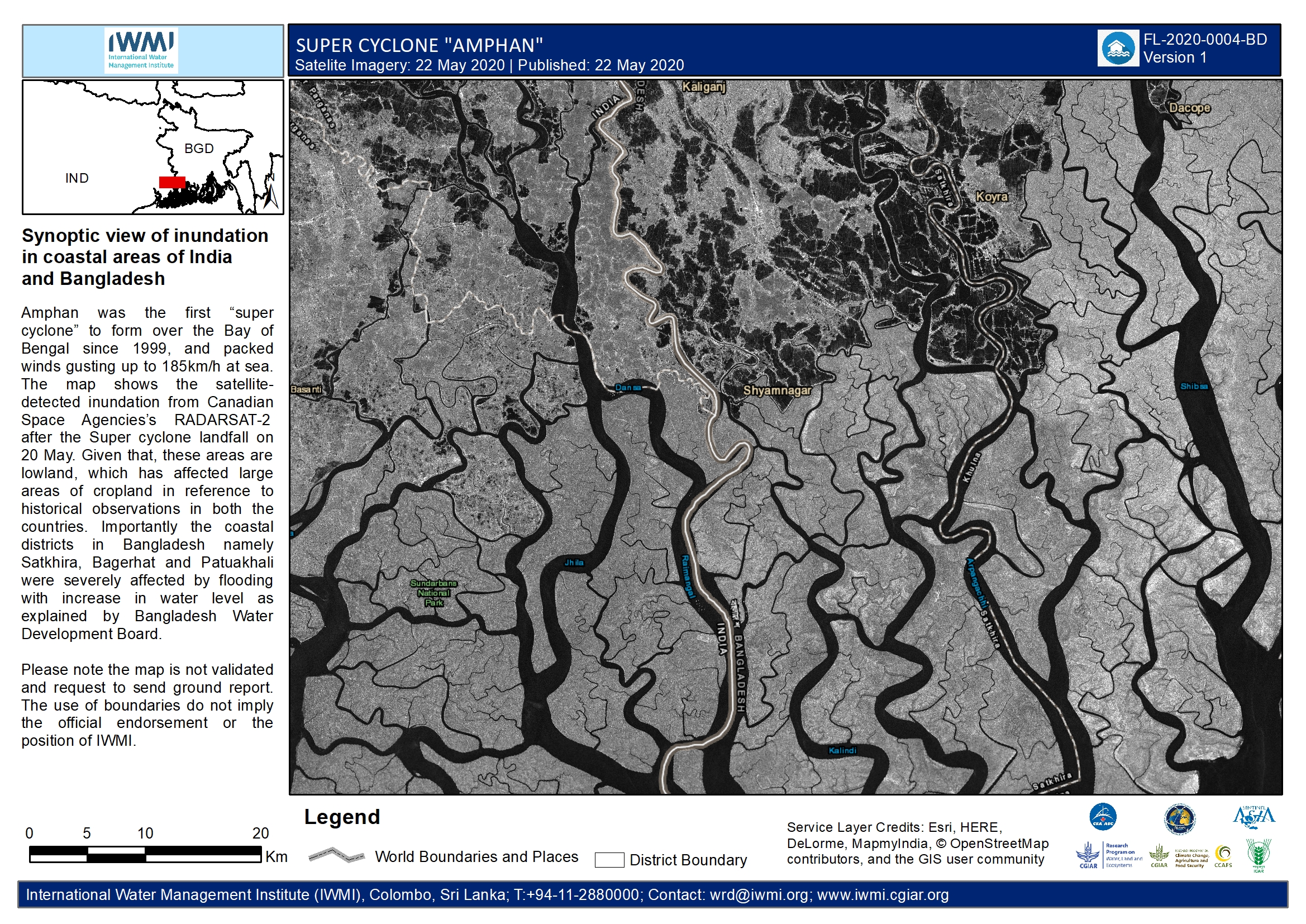
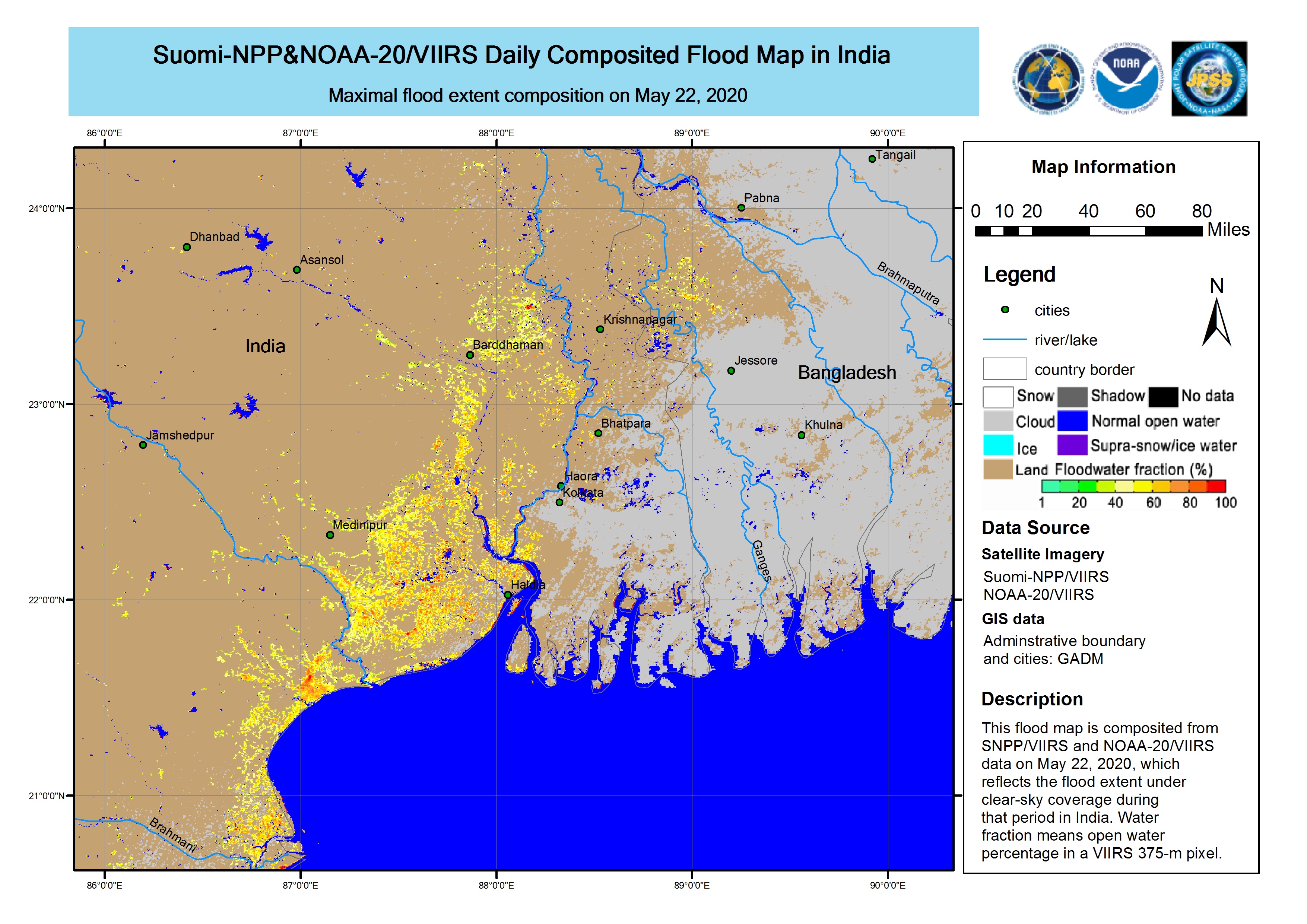
Synoptic view of inundation in coastal areas of India and Bangladesh
Direitos autorais: RADARSAT-2 Data and Products © Maxar Technologies Ltd. (2020) – All Rights Reserved
RADARSAT is an official mark of the Canadian Space Agency
Map produced by IWMI
Information about the Product
Adquirida: 22/05/2020
Fonte: RADARSAT-2
 Voltar ao arquivo completo da Ativação

