 English
 Spanish
 French
 Chinese
 Russian
 Portuguese
 Latest Activation
Charter activations
Hurricane Irma in Caribbean
Hurricane Irma, a Category 5 storm, ploughed through the Caribbean on 6 and 7 September 2017. The devastating storm left at least 44 dead and thousands of people were made homeless.
Hurricane Irma originated from a tropical storm which developed on 30 August 2017, and quickly developed into a full Category 5 storm. Category 5 is the highest grade on the Saffir-Simpson Hurricane Scale, and indicates a storm that could cause catastrophic damage.
When Irma passed over the Caribbean Isles it came with winds in excess of 250 km/h and brought heavy rain. The strong winds demolished many homes and inundated others. Estimates suggest 95% of the buildings on Barbuda and Saint Martin were destroyed or suffered damage, and 42% of the buildings on Anguilla were damaged. They were not the only islands affected by the disaster, though, and Irma also affected Saint Barthélemy, the Leeward Islands, the Virgin Islands and the Turks and Caicos Islands.
Residents of the islands have reported scenes of devastation, and it is feared it may take years for some of the nations to recover.
Rescue and recovery operations were delayed due to the hazards posed by the storm and extensive damage to transportation networks. International aid has been provided to the affected nations, but concerns for the provision of clean water, food and power remain for many residents.
| Tipo de evento: | Ocean Storm - Hurricane |
| Local do evento: | Caribbean |
| Data da Ativação da Carta: | 5 September 2017 |
| Tempo de Ativação da Carta: | 13:02:00 |
| Zona de Tempo da Ativação da Carta: | UTC+02:00 |
| Requisitante da Carta: | UNITAR-UNOSAT on behalf of UNDAC |
| ID da Ativação: | 548 |
| Gerenciamento de projeto: | UNITAR/UNOSAT |
Products
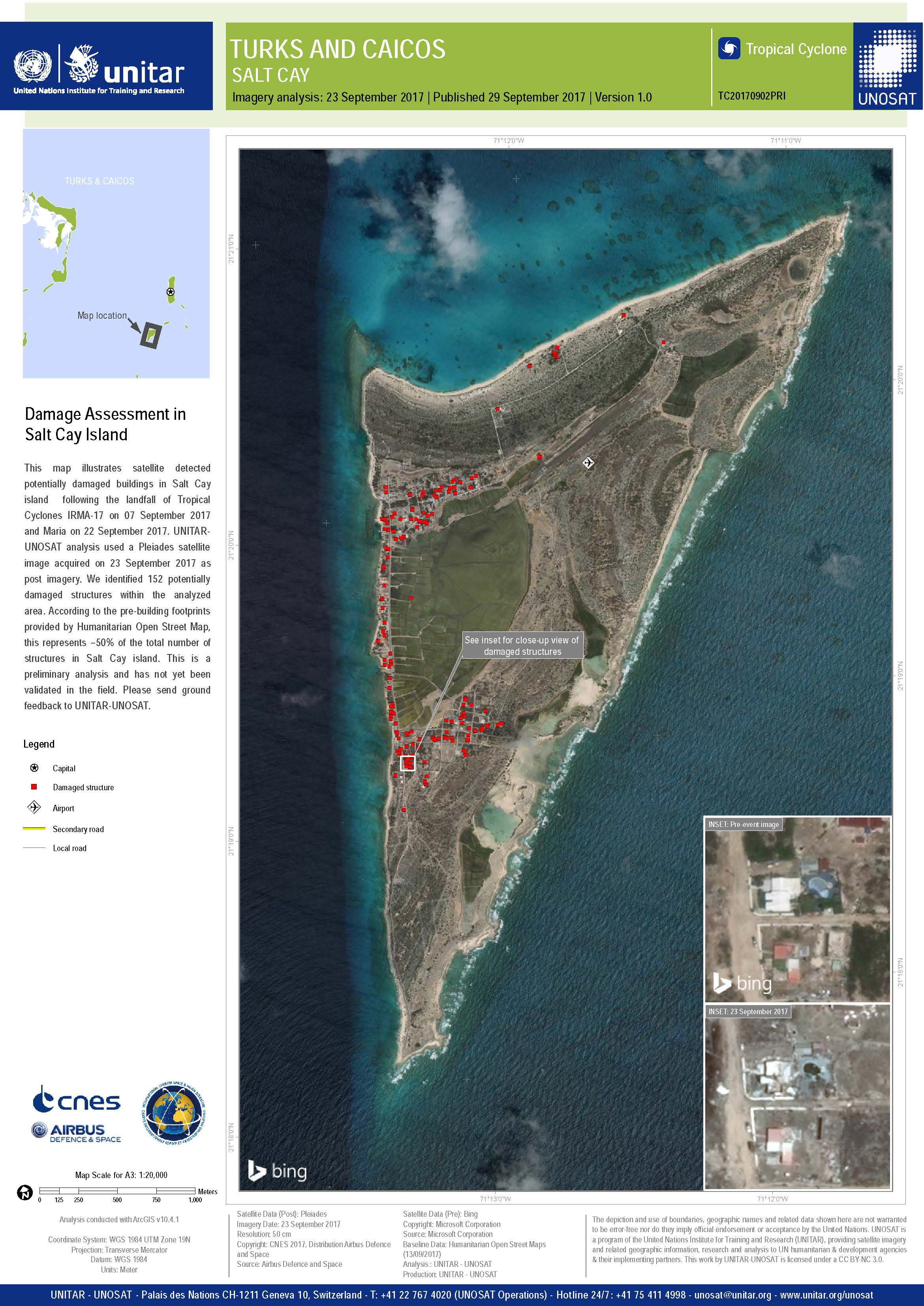
Damage Assessment in Salt Cay Island
Direitos autorais: Pleiades © CNES (2017) - Distribution: Airbus Defence and Space, all rights reserved
Map produced by UNITAR / UNOSAT
Information about the Product
Adquirida: 23/09/2017
Fonte: Pleiades
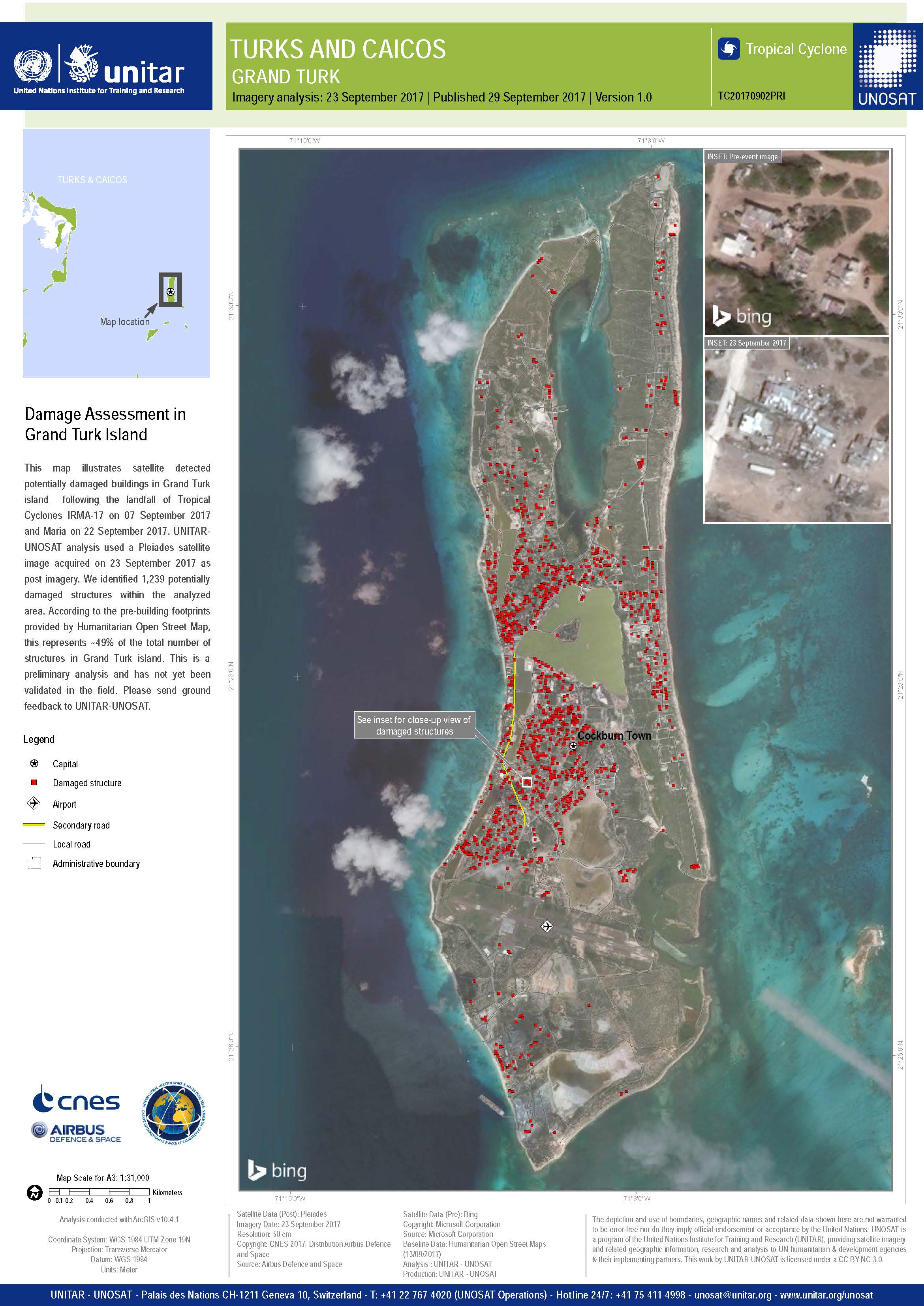
Damage Assessment in Turks and Caicos, Grand Turk Island
Direitos autorais: Pleiades © CNES (2017) - Distribution: Airbus Defence and Space, all rights reserved
Map produced by UNITAR / UNOSAT
Information about the Product
Adquirida: 23/09/2017
Fonte: Pleiades
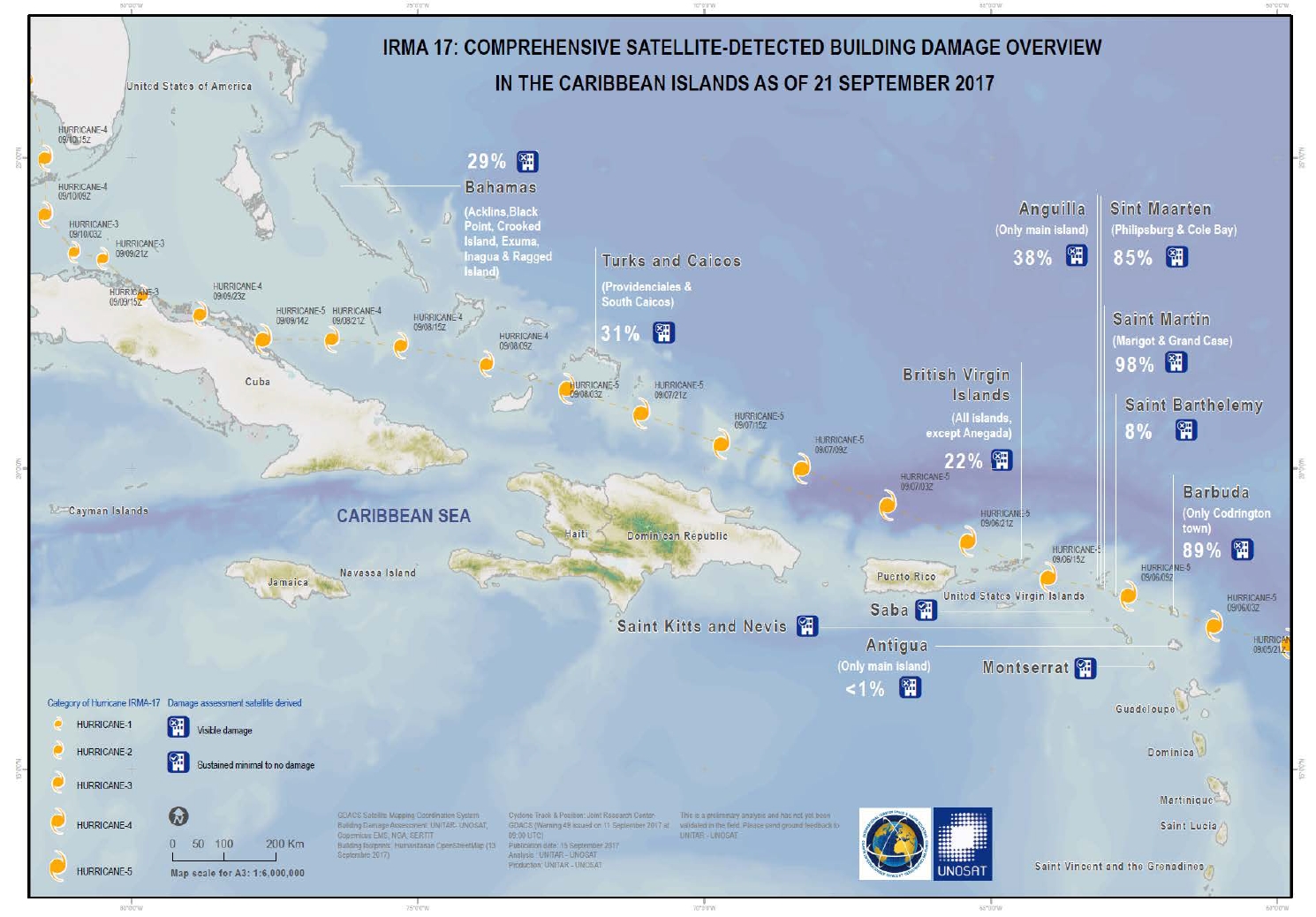
Comprehensive satellite detected building damage assessment of the Caribbean as of 21 September 2017
Download the full report
Direitos autorais: Report produced by UNITAR/UNOSAT
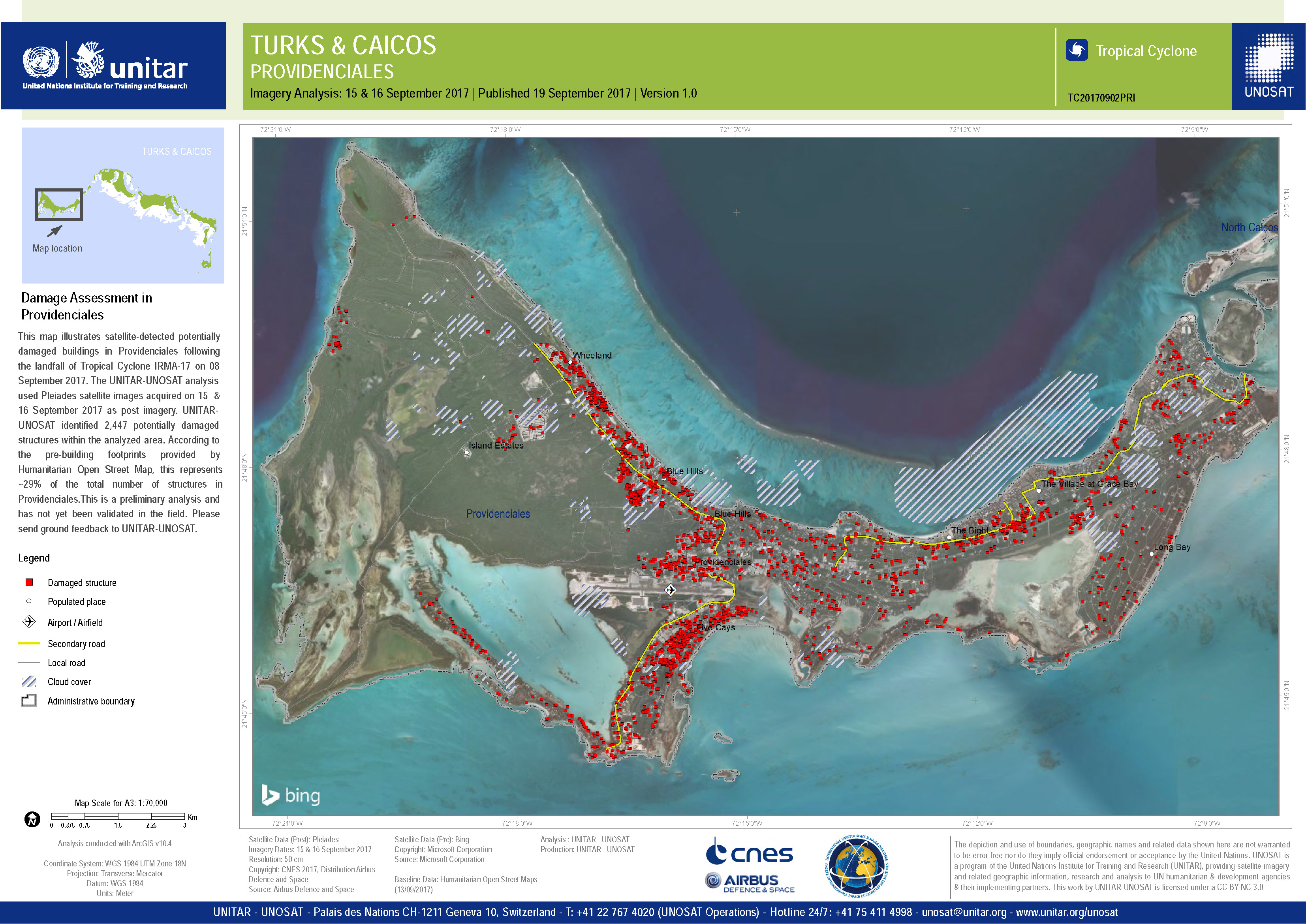
Damage assessment in Providenciales, Turks and Caicos
Direitos autorais: Pleiades © CNES (2017) - Distribution: Airbus Defence and Space, all rights reserved
Map produced by UNITAR/UNOSAT
Information about the Product
Adquirida: 15/09/2017 and 16/09/2017
Fonte: Pleiades
Damage assessment in South Caicos Island, Turks and Caicos
Direitos autorais: Pleiades © CNES (2017) - Distribution: Airbus Defence and Space, all rights reserved
Map produced by UNITAR/UNOSAT
Information about the Product
Adquirida: 15/09/2017
Fonte: Pleiades
Comprehensive satellite-detected building damage overview in the Caribbean Islands as of 15 September
Direitos autorais: Map produced by UNITAR/UNOSAT
Satellite detected waters in Barbuda
Direitos autorais: RADARSAT-2 Data and Products © MacDonald, Dettwiler and Associates Ltd. (2017) - All Rights Reserved. RADARSAT is an official trademark of the Canadian Space Agency.
Map produced by UNITAR/UNOSAT
Information about the Product
Adquirida: 11/09/2017
Fonte: RADARSAT-2
Damage Assessment Overview of Antigua
Direitos autorais: Pleiades © CNES (2017) - Distribution: Airbus Defence and Space, all rights reserved
WorldView-2 © DigitalGlobe Inc.
Report produced by UNITAR / UNOSAT
Information about the Product
Adquirida: 12/09/2017
Fonte: Pleiades/WorldView-2
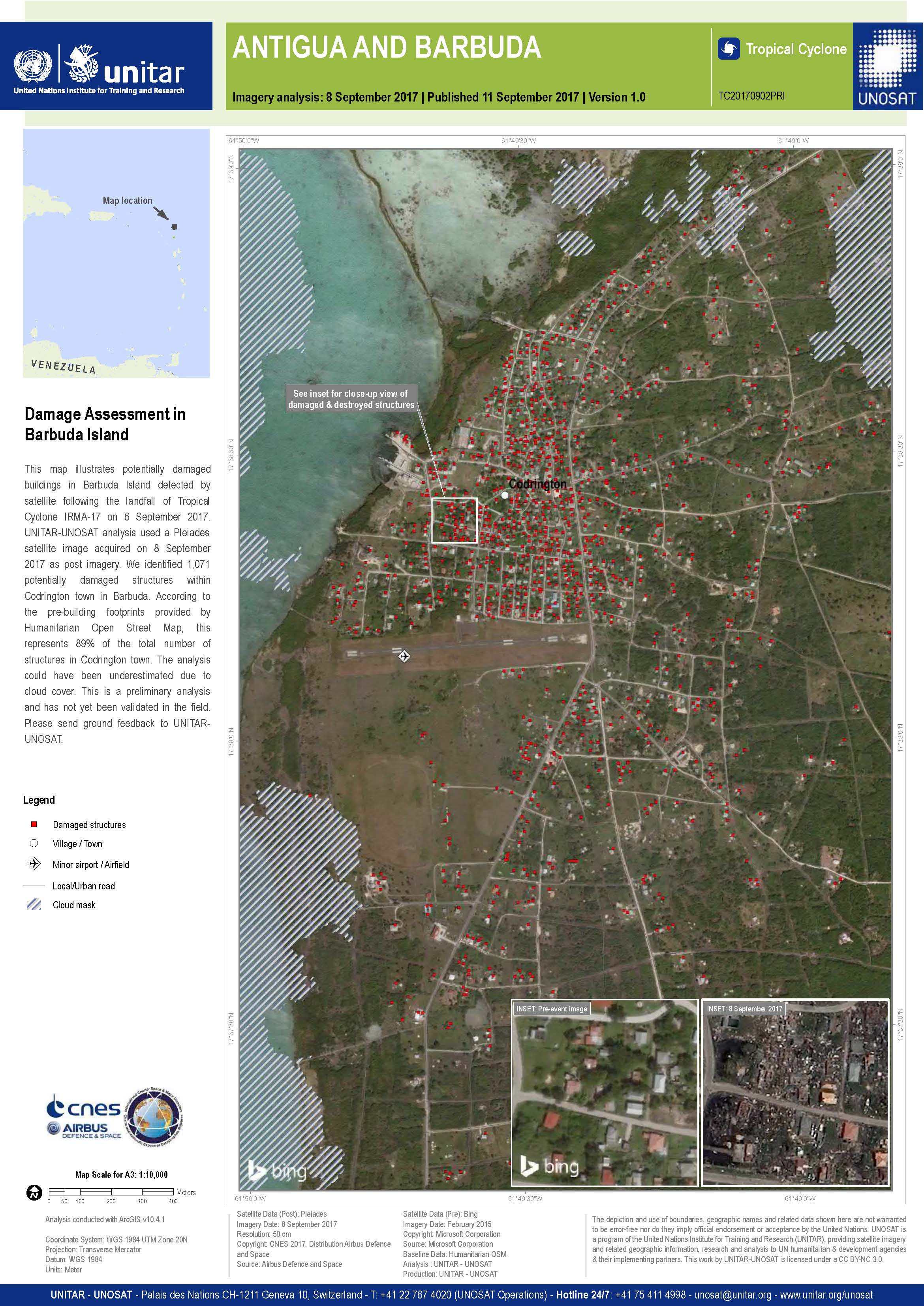
Damage assessment in Codrington town, Barbuda Island
Direitos autorais: Pleiades © CNES (2017) - Distribution: Airbus Defence and Space, all rights reserved
Map produced by UNITAR / UNOSAT
Information about the Product
Adquirida: 08/09/2017
Fonte: Pleiades
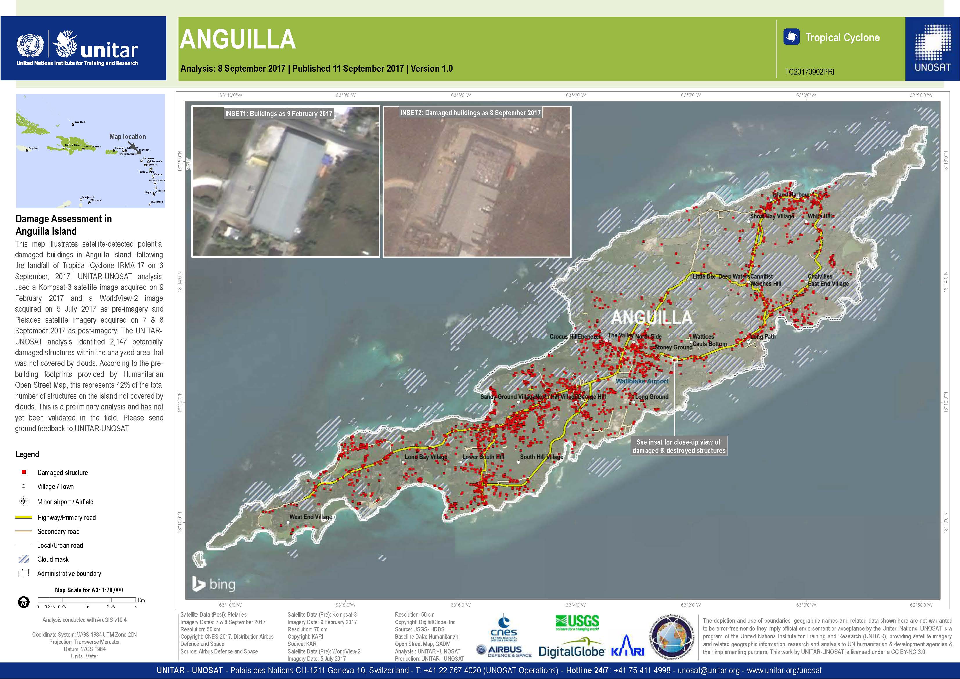
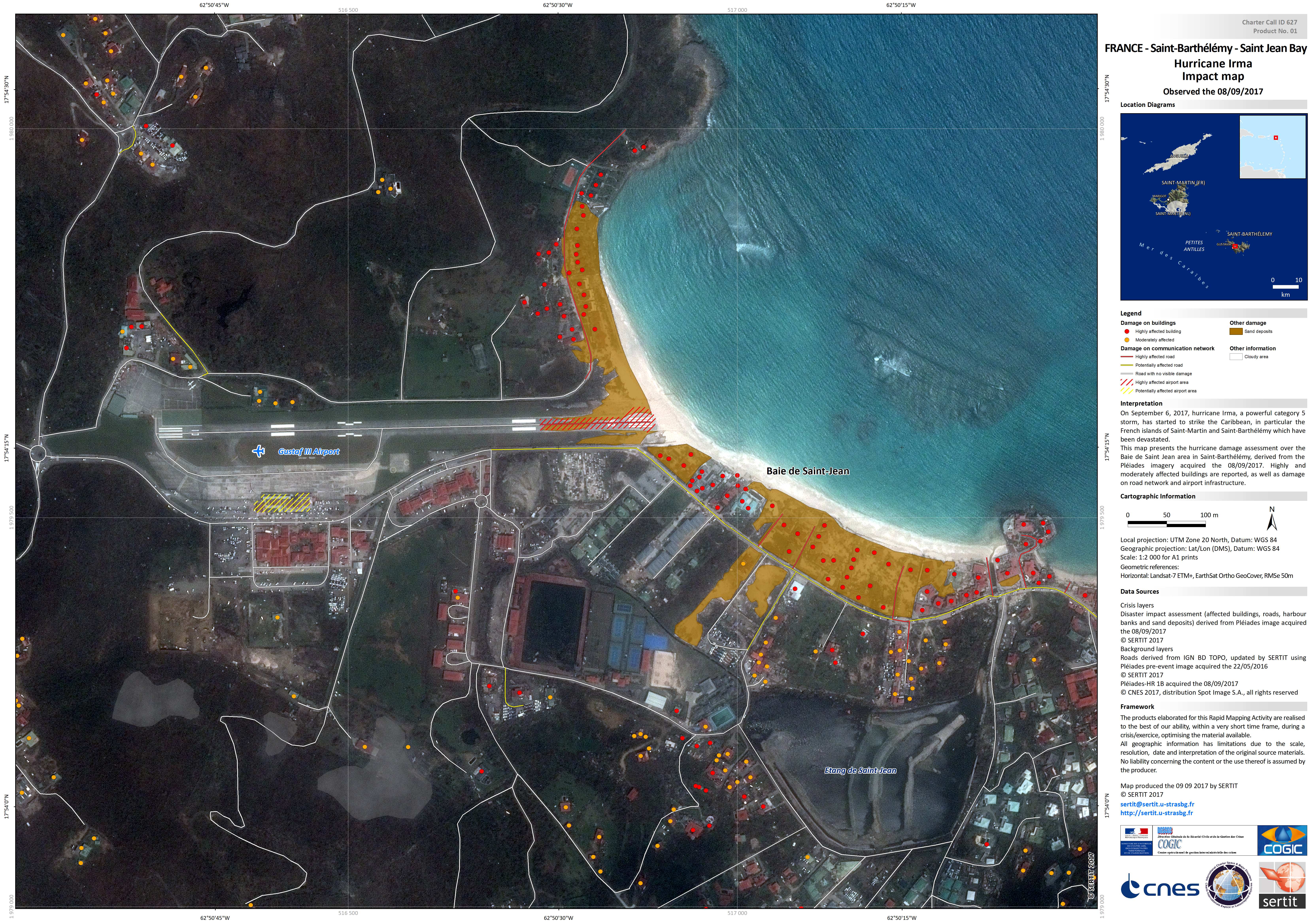
Damage assessment in Anguilla Island
Direitos autorais: Pleiades © CNES (2017) - Distribution: Airbus Defence and Space, all rights reserved
KOMPSAT-3 © KARI 2016
WorldView-2 © DigitalGlobe Inc.
Map produced by UNITAR / UNOSAT
Information about the Product
Adquirida: Pleiades: 07/09/2017 and 08/09/2017
KOMPSAT-3: 09/02/2017
WorldView-2: 05/07/2017
Fonte: Pleiades / KOMPSAT-3 / WorldView-2
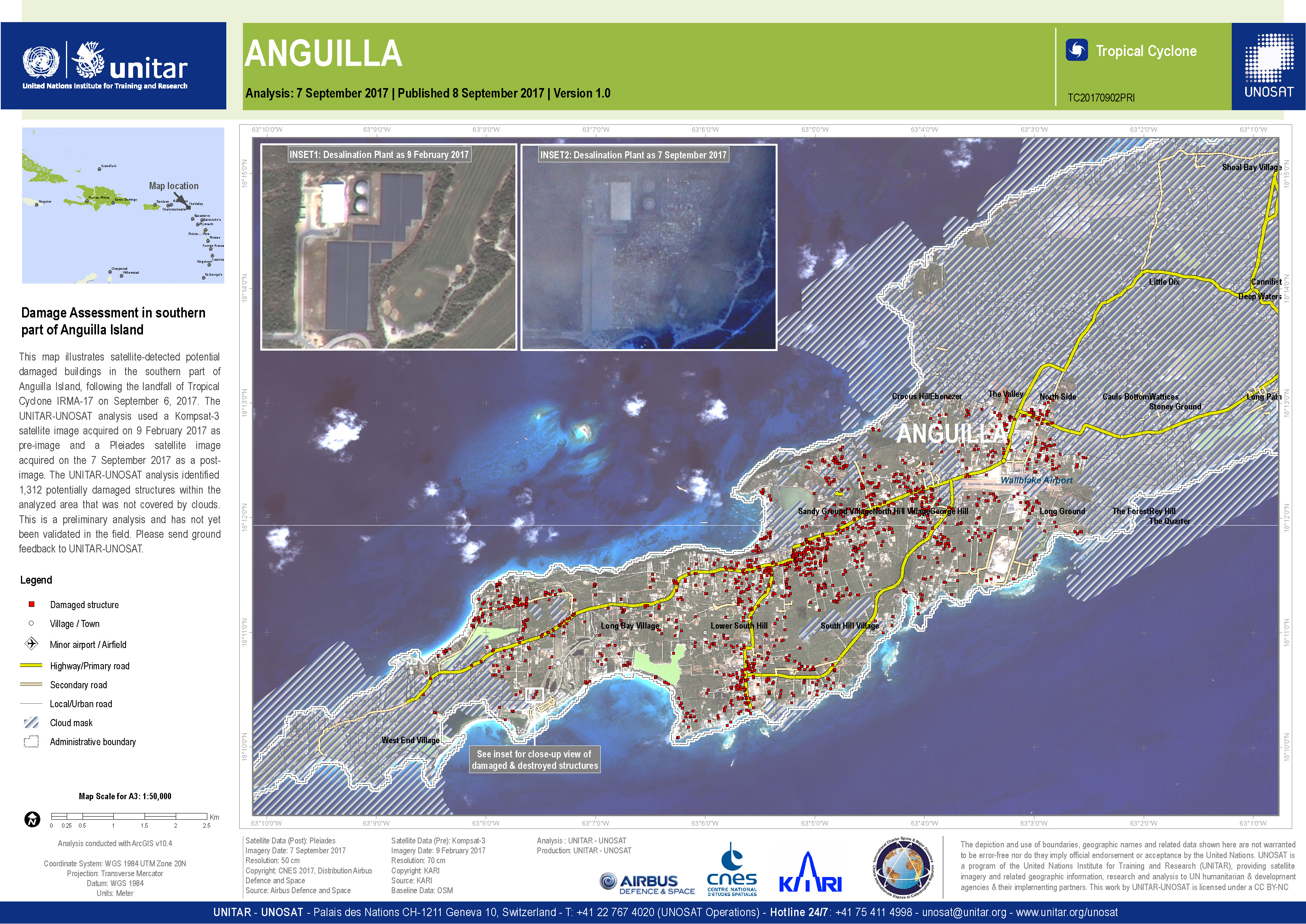
Damage assessment of the southern part of Anguilla island
Direitos autorais: Pleiades © CNES (2017) - Distribution: Airbus Defence and Space, all rights reserved
KOMPSAT-3 © KARI
Map produced by UNITAR/UNOSAT
Information about the Product
Adquirida: Pleiades: 07/09/2017
KOMPSAT-3: 09/02/2017
Fonte: Pleiades / KOMPSAT-3
 Voltar ao arquivo completo da Ativação
