 English
 Spanish
 French
 Chinese
 Russian
 Portuguese
 Latest Activation
Charter activations
Cyclone Seroja: Flash Flood and Landslide in Indonesia
Rains triggered by Tropical Cyclone Seroja on the islands in southeast Indonesia and have caused flooding and landslides that have killed more than 110 people officials have said, as they search for many others who are missing. Seroja hit the area as the storm tracked on a course for Western Australia, dumping heavy rain on the islands and triggering mudslides that buried homes and people.
| Type of Event: | Cyclone |
| Location of Event: | Indonesia |
| Date of Charter Activation: | 2021-04-06 |
| Time of Charter Activation: | 23:41 |
| Time zone of Charter Activation: | UTC+09:00 |
| Charter Requestor: | ADRC on behalf of LAPAN UNITAR on behalf of UNOCHA-Indonesia |
| Activation ID: | 702 |
| Project Management: | LAPAN |
Products
Preliminary Satellite Derived Damage Assessment in Kota Kupang District, Nusa Tenggara Timur Province, Indonesia
Download Full Report
Copyright: © Airbus Defence and Space Limited (2021)
Report produced by UNITAR and UNOSAT.
Information about the Product
Acquired: 14/04/2021
Source: Vision-1
Category: Dossier
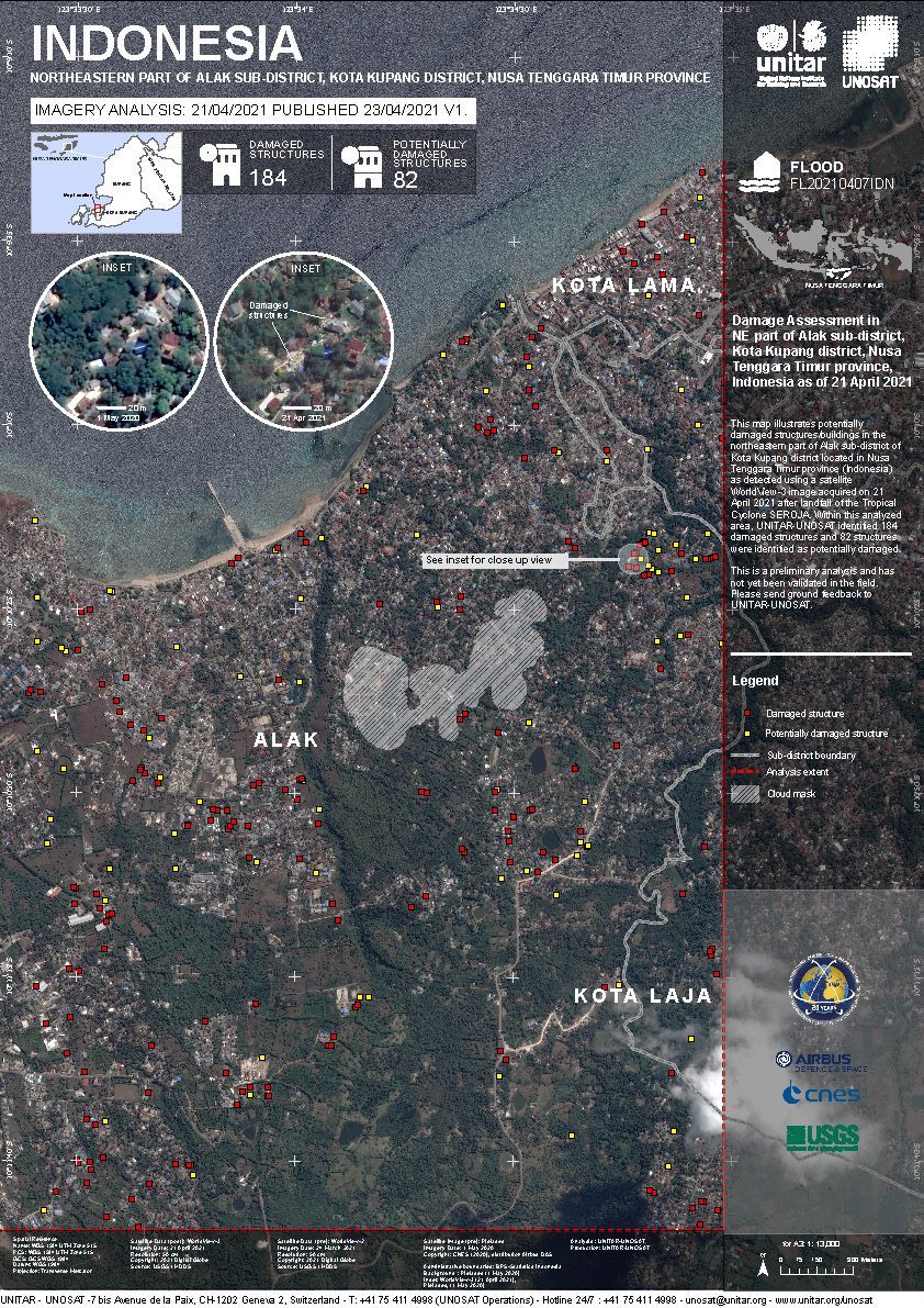
Damage assessment in Northeast part of Alak Sub-District and Kota Kupang District Indonesia
Copyright: © (2021) DigitalGlobe, Inc., Longmont CO USA 80503. DigitalGlobe and the DigitalGlobe logos are trademarks of DigitalGlobe, Inc. The use and/or dissemination of this data and/or of any product in any way derived there from are restricted. Unauthorized use and/or dissemination is prohibited
Map Produced by UNITAR / UNOSAT
Information about the Product
Acquired: 21/04/2021
Source: WorldView-3
Preliminary Satellite Derived Agricultural Damage Assessment in Kupang District and Nusa Tenggara Timur Province, Indonesia
Download Full Report
Copyright: © Airbus Defence and Space Limited (2021)
Map produced by UNOSAT and UNITAR.
Information about the Product
Acquired: 14/04/2021
Source: Vision-1
Category: Dossier
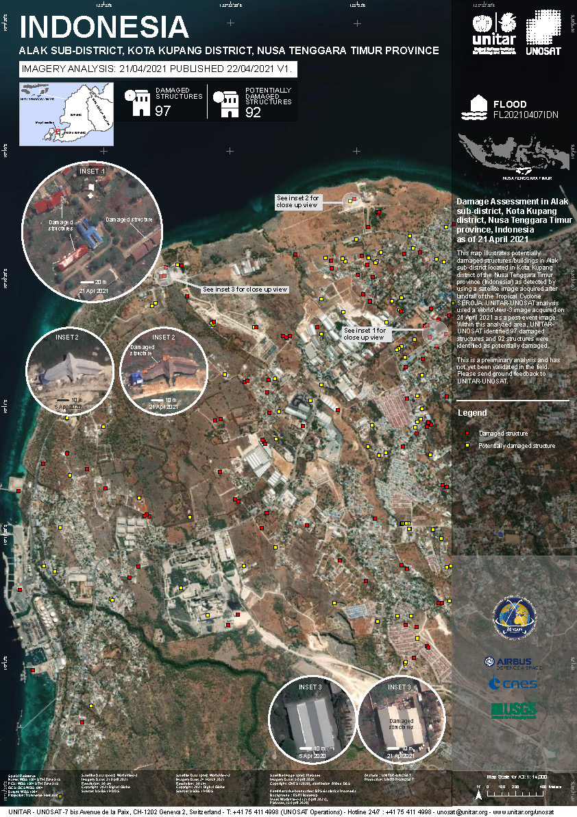
Damage assessment in Alak Sub District and Kota Kupang district Indonesia
Copyright: © (2021) DigitalGlobe, Inc., Longmont CO USA 80503. DigitalGlobe and the DigitalGlobe logos are trademarks of DigitalGlobe, Inc. The use and/or dissemination of this data and/or of any product in any way derived there from are restricted. Unauthorized use and/or dissemination is prohibited
Map produced by UNITAR / UNOSAT
Information about the Product
Acquired: WorldView-3: 21/04/2021
Source: WorldView-3
Damage assessment in Kupang and Kota Kupang districts, Nusa Tenggara Timur Province, Indonesia
Copyright: © (2021) DigitalGlobe, Inc., Longmont CO USA 80503. DigitalGlobe and the DigitalGlobe logos are trademarks of DigitalGlobe, Inc. The use and/or dissemination of this data and/or of any product in any way derived there from are restricted. Unauthorized use and/or dissemination is prohibited
Map Produced by UNITAR / UNOSAT
Information about the Product
Acquired: 21/04/2021
Source: WorldView-3
Preliminary Satellite Derived Agricultural damage assessment in Sabu Raijua and Rote Ndao District Indonesia.
Download full report
Copyright: © (2021) DigitalGlobe, Inc., Longmont CO USA 80503. DigitalGlobe and the DigitalGlobe logos are trademarks of DigitalGlobe, Inc. The use and/or dissemination of this data and/or of any product in any way derived there from are restricted. Unauthorized use and/or dissemination is prohibited
Map produced by UNITAR / UNOSAT
Information about the Product
Acquired: 22/04/2021
Source: WorldView-3
Map of buildings affected by flash floods at Nelelamadike Village, Ile Boleng Regency, Flores Timur District, Nusa Tenggara Timur Province
Copyright: Includes Pleiades material © CNES (2021), Distribution Airbus DS.
Map produced by LAPAN
Information about the Product
Acquired: 08/04/2021
Source: Pleiades
 Back to the full activation archive

