最小化 最新宪章启动

Charter activations

乌拉圭洪水

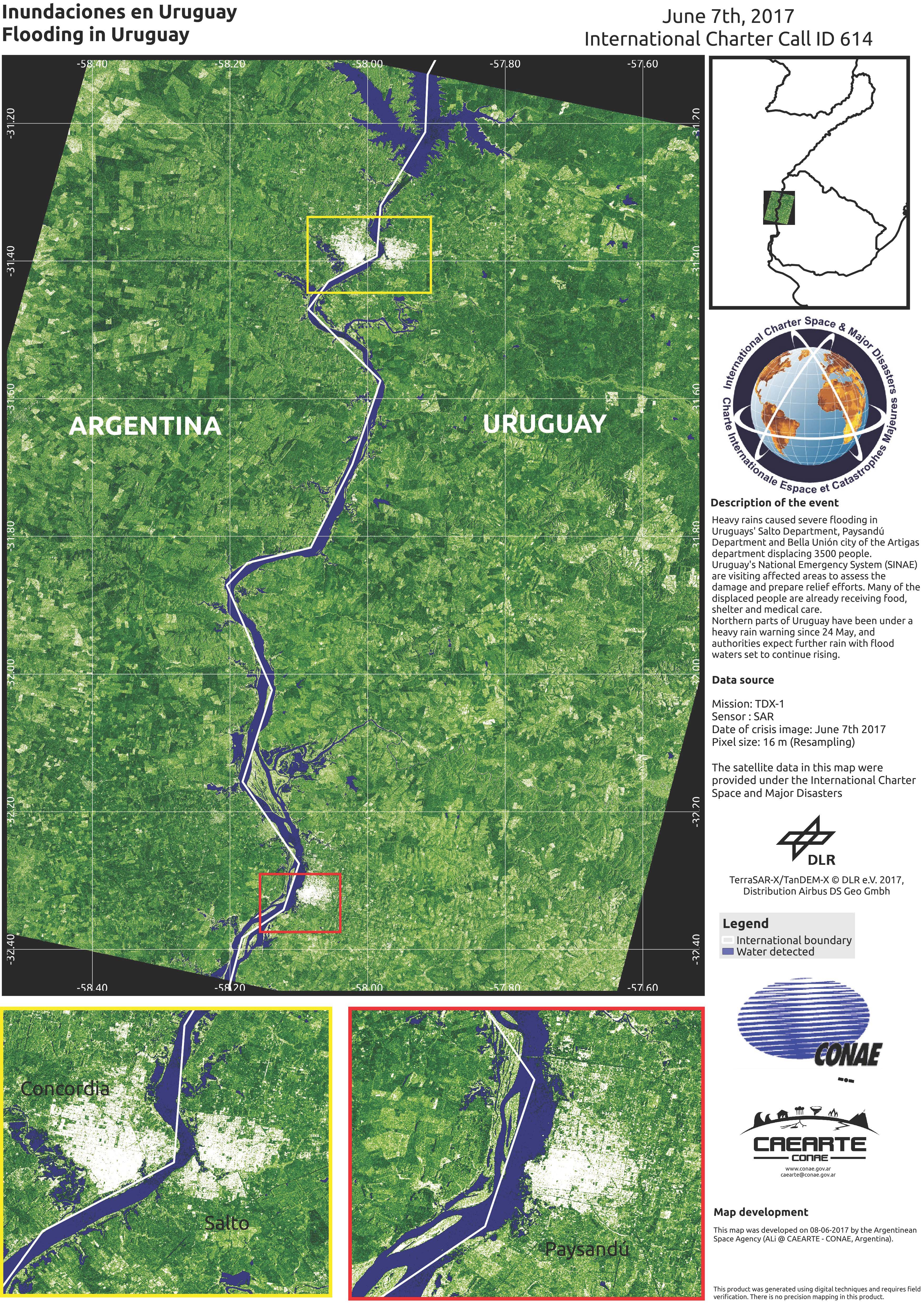
乌拉圭萨尔托省、派桑杜省和阿蒂加斯省的贝亚乌尼翁市遭受了大雨袭击,造成3500人无家可归。

乌拉圭国家应急系统(SINAE)正在巡视受灾地区,评估损毁情况并做好救援工作。许多难民已经得到食物、住所和医疗保健服务。

乌拉圭北部地区自5月24日以来一直处于暴雨警戒之下,当局预计随着洪水水位的持续上升,仍会降雨不断。

事件地点:乌拉圭
启动宪章的日期:2017年6月6日
宪章启动时间:15:17:00
宪章启动时区:UTC+03:00
宪章要求者:国家应急系统 - 共和国总统
启动ID:535
项目经理:CONAE(阿根廷航天局)

Products

Flooding in Uruguay

版权: CartoSat-2 data © ISRO (2017), all rights reserved
Map produced by CONAE

Information about the Product

已获得: 20/06/2017

源: CartoSat-2

Comparison of flooding in Uruguay

版权: RADARSAT-2 Data and Products © MacDonald, Dettwiler and Associates Ltd. (2017) - All Rights Reserved. RADARSAT is an official trademark of the Canadian Space Agency.
Map produced by CONAE

Information about the Product

已获得: Pre-disaster: 22/02/2017
Post-disaster: 08/06/2017

源: RADARSAT-2

Flood at Salto

版权: SPOT-6 © CNES 2017 - Distribution: Airbus DS, all rights reserved
Map produced by CONAE

Information about the Product

已获得: 11/06/2017

源: SPOT-6

Flooding in Uruguay

版权: SPOT-6 © CNES 2017 - Distribution: Airbus DS, all rights reserved
Map produced by CONAE

Information about the Product

已获得: 11/06/2017

源: SPOT-6

Flooding at Paysandu

版权: SPOT-6 © CNES 2017 - Distribution: Airbus DS, all rights reserved
Map produced by CONAE

Information about the Product

已获得: 11/06/2017

源: SPOT-6

Flooding in Uruguay

版权: CartoSat-2 data © ISRO (2017). All rights reserved
Map produced by CONAE

Information about the Product

已获得: 10/06/2017

源: CartoSat-2

Flooding in Uruguay

版权: CartoSat-2 data © ISRO (2017). All rights reserved
Map produced by CONAE

Information about the Product

已获得: 10/06/2017

源: CartoSat-2

Flooding in Concordia and Salto Region, Uruguay

版权: ALOS © JAXA (2016) All rights reserved
Map produced by CONAE

Information about the Product

已获得: 08/06/2017

源: ALOS-2

Flooding in Monte Caseros and Bella Unión, Uruguay

版权: ALOS © JAXA (2016) All rights reserved
Map produced by CONAE

Information about the Product

已获得: 08/06/2017

源: ALOS-2

Flooding in Salto Department, Paysandú Department and Bella Unión City, Uruguay

版权: CartoSat-2 data © ISRO (2017). All rights reserved
Map produced by CONAE

Information about the Product

已获得: 11/06/2017

源: CartoSat-2

Flooding in Salto Department, Paysandú Department and Bella Unión City, Uruguay

版权: ALOS © JAXA (2016) All rights reserved
Map produced by CONAE

Information about the Product

已获得: 08/06/2017

源: ALOS-2

Flooding in Salto Department, Paysandú Department and Bella Unión City, Uruguay

版权: ALOS © JAXA (2016) All rights reserved
Map produced by CONAE

Information about the Product

已获得: 08/06/2017

源: ALOS-2

Flooding in Uruguay

版权: SPOT-7 © CNES 2017 - Distribution: Airbus DS, all rights reserved
Map produced by CONAE

Information about the Product

已获得: 10/06/2017

源: SPOT-7

Flooding in Uruguay

版权: SPOT-7 © CNES 2017 - Distribution: Airbus DS, all rights reserved
Map produced by CONAE

Information about the Product

已获得: 10/06/2017

源: SPOT-7

Flooding in Uruguay

版权: SPOT-7 © CNES 2017 - Distribution: Airbus DS, all rights reserved
Map produced by CONAE

Information about the Product

已获得: 10/06/2017

源: SPOT-7

Flooding in Uruguay

版权: RADARSAT-2 Data and Products © MacDonald, Dettwiler and Associates Ltd. (2017) - All Rights Reserved. RADARSAT is an official trademark of the Canadian Space Agency.
Map produced by CONAE

Information about the Product

已获得: 08/06/2017

源: RADARSAT-2

Flooding in Uruguay

版权: RADARSAT-2 Data and Products © MacDonald, Dettwiler and Associates Ltd. (2017) - All Rights Reserved. RADARSAT is an official trademark of the Canadian Space Agency.
Map produced by CONAE

Information about the Product

已获得: 08/06/2017

源: RADARSAT-2

Flooding in Uruguay

版权: TanDEM-X © DLR e. V. 2017, Distribution: Airbus DS Geo GmbH
Map produced by CONAE

Information about the Product

已获得: 07/06/2017

源: TanDEM-X

返回完整的响应档案