 English
 Spanish
 French
 Chinese
 Russian
 Portuguese
 最新宪章启动
Charter activations
马达加斯加洪水
热带气旋埃纳弗已被列为多年来袭击马达加斯加的最具破坏性的风暴,风速超过231公里/小时,成为萨菲尔-辛普森飓风等级的第四类飓风。援助组织警告说,超过70万人可能受到风暴的影响,但有报道指出,随着第四类气旋临近首都塔那那利佛,已经造成人身伤亡。
此外,美国国家海洋和大气局的国家飓风中心报告说,第四类飓风能对住宅和基础设施造成严重破坏;树木将被吹倒,电力杆将倒塌,造成停电持续数周至数月。因此,大部分地区在数周或数月内无法居住在原来的地方。
| 事件类型: | 海洋风暴 - 气旋 |
| 事件地点: | 马达加斯加 |
| 启动宪章的日期: | 2017年3月6日 |
| 宪章启动时间: | 11:49:00 |
| 宪章启动时区: | UTC+01:00 |
| 宪章要求者: | UNITAR(联合国调查训练研究所)- UNOSAT(联合国卫星应用计划训练与研究营运中心)代表联合国人道事务协调厅 |
| 启动ID: | 521 |
| 项目经理: | UNITAR(联合国调查训练研究所) |
Products
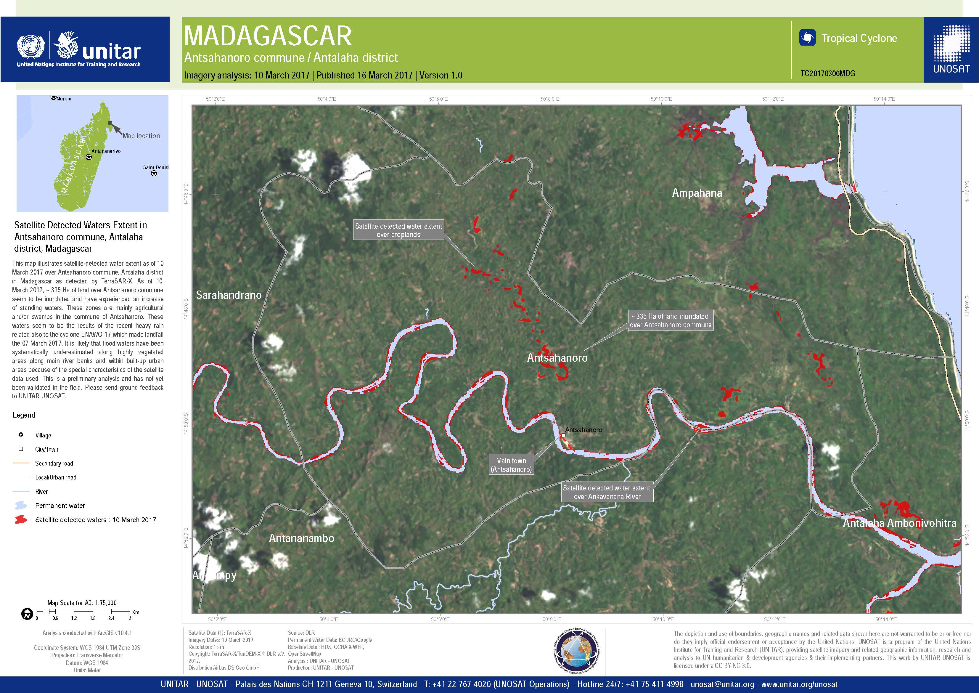

Satellite detected waters extent and evolution in Maroantsetra area, Analanjirofo region, Madagascar
版权: TerraSAR-X DLR e. V. 2017, Distribution: Airbus DS Geo GmbH
RADARSAT-2 Data and Products © MacDonald, Dettwiler and Associates Ltd. (2017) - All Rights Reserved. RADARSAT is an official trademark of the Canadian Space Agency.
Map produced by UNITAR / UNOSAT
Information about the Product
已获得: TerraSAR-X: 08/03/2017 and 10/03/2017
RADARSAT-2: 04/05/2014
源: TerraSAR-X / RADARSAT-2
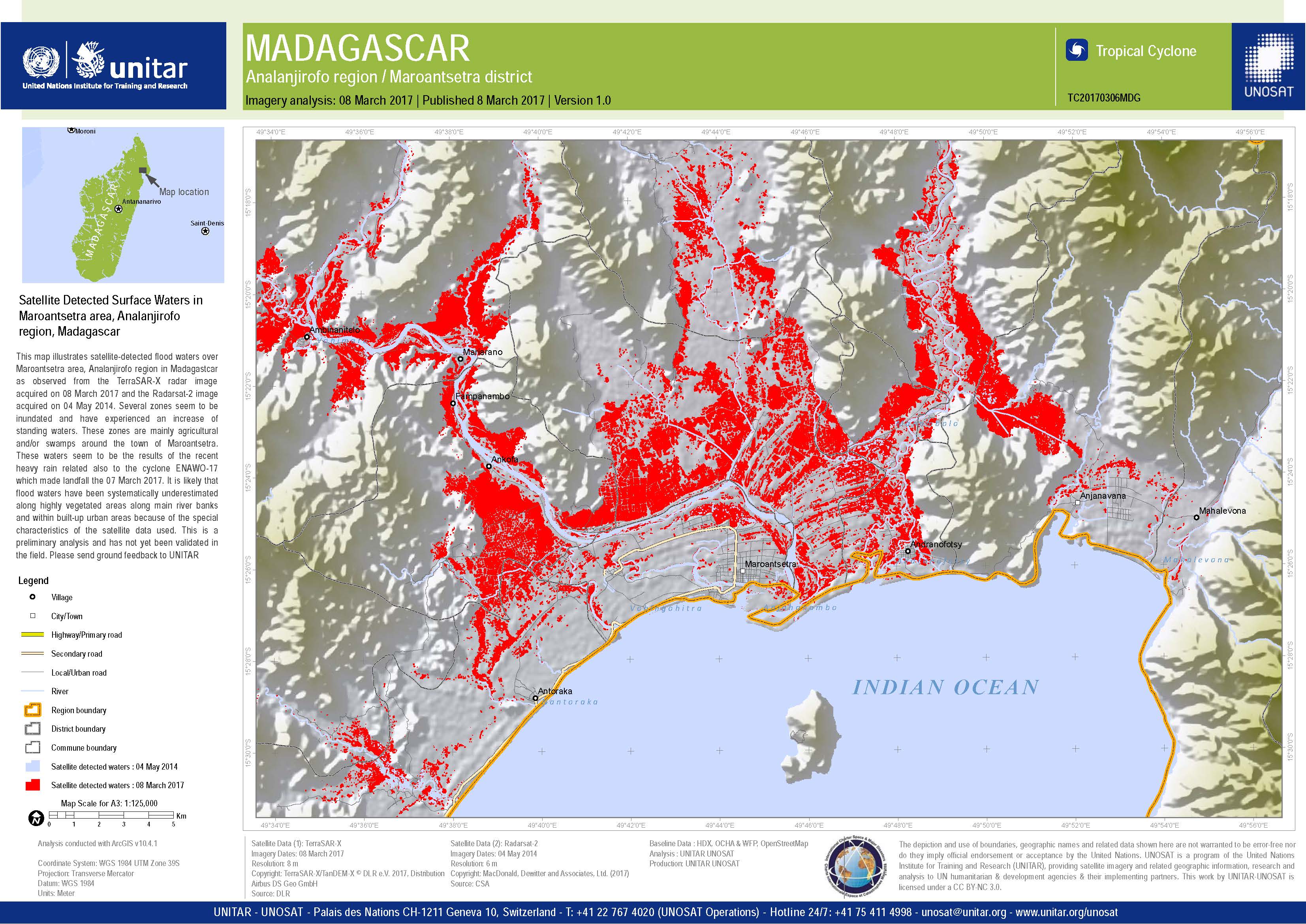
Satellite detected surface water in Maroantsetra area, Madagascar
版权: RADARSAT-2 Data and Products © MacDonald, Dettwiler and Associates Ltd. (2017) - All Rights Reserved. RADARSAT is an official trademark of the Canadian Space Agency.
TerraSAR-X DLR e. V. 2017, Distribution: Airbus DS Geo GmbH
Map produced by UNITAR / UNOSAT
Information about the Product
已获得: RADARSAT-2: 08/03/2017
TerraSAR-X: 04/05/2014
源: RADARSAT-2 / TerraSAR-X
Population exposure analysis of Madagascar following Tropical Cyclone Enawo on 07 March 2017
Download the full report
版权: Report produced by UNITAR/UNOSAT
Population exposure analysis of Madagascar following Tropical Cyclone Enawo on 06 March 2017
Download the full report
版权: Report produced by UNITAR/UNOSAT
 返回完整的响应档案

